Pesisir & Lautan Volume 4, No.2, 2002
- - -
POLICY ANALYSIS
OF COASTAL ECOTOURISM DEVELOPMENT
O N MUARA ANGKE MANGROVE ECOSYSTEM,
JAKARTA BAY, INDONESIA
MYINT T H U ZAR
Yezin Agricultural University, Myanmar
DIETRIECH G. BENGEN
Pusat Kajian Sumberdaya Pesisir dan Lautan
Institut Pertanian Bogor
e-mail:[email protected]
DANIEL R. MONINTJA
Fakultas Perikanan dan Ilmu Kelautan
Institut Pertanian Bogor
ABSTRACT
T
he mangrove ecosystem is one ofimportant ecosystems in the tropics and has great economic and ecotourism potential. The multiple roles of mangrove ecosystems in coastal ecotourism areas are now well recognized in Indonesia. Ecotourism is ecologically sustainable tourism that is related with forest environmental and cultural understanding, appreciation and conservation.Information on mangrove ecosystems of the Jakarta Bay is mostly concerned with the flora and fauna aspects. The mangrove ecosystems in the area have a very limited diversity. The importance of mangrove forest productivity in the function ofthe coastal ecosystem of Jakarta Bay cannot be ignored. A lot of development activities have negatively affected this area. The balance between economic gain and environment social loss should be weighted in favor ofthe longer - term objectives so that establish- ment ofsustainable resources development will not be ignored. Attention should also be paid to the impact ofcoastal ecotourism development on the sustainability and conservancy of mangrove ecosystem. This research was conducted from September to November 2001 at Muara Angke ofNorth Jakarta in Jakarta Bay. This research aimed to:
(1) examine the environmental suitability of mangrove ecosystem and coastal area for ecotourism development,
(2) obtain the optimum plans for the associated enterprise in relation to variables and parameters which relate the potential use ofphysical, economic and institutional restraints while considering the objectives of entrepreneur and policy planners, (3) recommend the appropriate mangrove areas for ecotourism that would have the least effect for the coastal environment and
the social activities of the local people.
Geographic Information System (GIs) method was used for evaluating the mangrove ecosystem suitability and Analytical Hierarchy Process approach was used for resolving the spatiallland use conflict to evaluate policy. The software program Expert Choice (3.1) is incorporated in the AHP methodology and enables the analyst to structure the hierarchy and resolve the problem using absolute measurement as appropriate.
The result showed that all along the Northern coast ofwhat now is DKI Jakarta was originally mangrove forest ecosystem, complete with all richness of bio-diversity attained in it. However Indonesia should utilize institutional facility presently available as soon as possible, such as forestry agency, tourism agency, and other related institutions, which can act professionally and responsibly in the effort to develop coastal ecotourism better, especially mangrove forest ecosystem, so a coastal ecotourism project can be sustainable.
Policy Analys~s of Coastal Ecotourism Development.. . . . (9 - 24)
- - --
-
ABSTRAK
Ekosistem mangrove merupakan salah satu ekosistem penting di daerah tropika dan memiliki potensi ekonomi dan ekowisata yang bcsar. Reragam peranan ekosistem mangrove dalam ekowisata pesisir di Indonesia, pada saat ini diakui secara luas. Ekowisata adalah kegiatan pariwisata yang secara lingkungan (ekologis) berkesinambungan, yang terkait dengan pcmahaman, penghargaan dan pelestarian lingkungan darl budaya.
Informasi mengenai ekosistem mangrove di Teluk Jakarta sebagian besar berkaitan dengan aspek flora dan fauna. Ekosistem mangrove di daerah ini mernpunyai keragaman yang sangat terbatas. Pentingnya produktivitas ekosistem mangrove dalam hngsi-filngsi ekosistem pesisir di Teluk Jakarta tidak dapat diabaikan begitu saja. Banyak kegiatan pembangunan yang berdampak negatif pada wilayah tersebut. Suatu keseimbangan antara keuntungan ekonomis dan kerugian-kerugian sosial dan lingkungan haruslah diberi bobot yang patut demi tujuan-tujuan jangka panjang, sehingga terbentuknya pemanfaatanlpengembangan sumberdaya yang berkelanjutan tidaklah disia-siakan. Perhatian hendaknya diberikan terhadap dampak pengembangan ekowisata pesisir terhadap kelestarian ekosistem mangrove. Penelitian ini dilaksanakan dari bulan September sarnpai dengan November
2001 di daerah Muara Angke Jakarta Utara, Teluk Jakarta. I'enelitian ini dimaksudkan untuk:
( 1 ) mengkaji kesesuaian lingkungan ekosistem mangrove dan wilayah pcsisir guna pengembangan ekowisata,
(2) mernperoleh rencana optimal ekowisata, yang berhubungan dengan variabel (peubah) dan parameter yang terkait dengan penggunaan potensi dari kerldala fisik, ekonomi dan kelembagaan, dengan mempertimbangkan sasaran yarlg ingin diraih oleh pengusaha dan perencana kebijakan,
( 3 ) merekomendasikan daerah-daerah mangrove yang sesuai untuk ekowisata yang akan memilikilmendapat dampak terkecil terhadap lingkungan pesisir dan kegiatan-kegiatan sosial penduduk setcmpat.
Sistem Informasi Geografis (SIG) dalam evaluasi kesesuaian ekosistem mangrove, dan Proses Hirarlu Analitik (PHA) diterapkan dalam mencari penyelesaian konflik pemanfaatan ruangllahan. I'iranti lunak Expert Choice versi 3.1 digunakan dalam pengerjaan PHA (Proses Hirarki Analitik) dan menlungkinkan penganalisa dalam strukturisasi hirarki dan memecahkan masalah dengan memakai penilaian mutlak bilamana diperlukan.
Scpanjang pantai utara DKI Jakarta pada mulanya merupakan ekosistem hutan mangrove dengan kekayaan keanekaraganian hayati. Bagaimanapun Indonesia sebaiknya tnemanfaatkan fasilitw: kelembagaan yang tersedia sekarang, misalnya pihak kehutanan, agen-agen pariwisata dan lembaga terkait lainnya, yang dapat bertindak secara profesional dan bertanggung jawab dalam upaya mengembangkan ekowisata pesisir yang lebih baik, kh~~susnya dalam hal ekosistem mangrove, sehingga program ekowisata pesisir tersebut dapat berkesinambungan.
Kata kunci: analisis kebijakan, ekosistem mangrove, ekowisata pesisir, SIG, PHA.
INTRODUCTION
Background
Mangroves live in community and roles in main- taining estuaries and shoreline and also become as habi- tat for various lund of animals. The tropical mangrove ecosystem is forest influenced by tides over the wide area about 180.000
km'
(Spalding et al, 1997). Man- grove is existing around mouth of the great rivers and bay area and found in tropical countries which have high annual rainfall. Mangrove forest is primary com- ponent of coastal ecosystem and promoting land ac- cretion, fixation of mud banks, dissipation of winds, tidal and wave energy.Indonesia's mangrove forests are supposed to be the world's largest and described as wood sources in coastal area (coastal woodland).
Ecologically mangroves are important in maintaining and building the soil, as a reservoir in the tertiary assimilation of waste, a n d in the global cycle of carbon dioxide, nitrogen, and sul-
phur. T h e protection against cyclones are a "free" benefit. Yet hidden benefits from mangroves, es- pecially in marginal areas, may even be more im- portant than the obvious ones. They play a sig- nificant role in coastal stabilisation, but environ- mentalists here say their area has been cut in half by decades of export-oriented aquaculture. This kind of development has been encouraged by in- ternational financial institutions. T h e World Bank and other international donors, according to studies being undertaken by environmental groups here, for example, have often financed shrimp cultivation.
Pesisir & Lautan
-- - -- Volume 4, N O . ~ , 2002
The policy is fundamental requirement for the development and use of mangrove ecosystem marine resources and for special management of enclosed, such a policy establishes objectives and priorities and lays down basic principles and criteria which provide guidance for the formula- tion of plans and programmes and a coastal ecotourism development strategy. T h e policy should outline a framework that identifies the
fi-
nancial, human, technical and institutional re- sources needed. The government has already en- acted Environment Law No.2311997
to protect the mangrove ecosystem.As mentioned above, the mangrove natural resources and environment are being deteriorated in the Jakarta area. A lot of development activities have negatively affected this area. If the situation continues, the environmental problems in Jakarta will become more severe. Such harmful activities require the sufficient planning and management to avoid conflicts and maintain the environmen- tal quality scenery and scientific value. However, this is not possible without ecological knowledge and adequate techniques that are available for man- grove management. Therefore, using Geographic Information System
(GIs)
techniques are useful tools to support a multi-sector resource planning and sustainable management for the Jakarta Bay.Statement of the Problem
The main problem for mangrove forests in Indonesia is their degradation by conversion to fish or shrimp farms, known locally as tambak. Man- grove forests are also over-exploited for firewood, house construction, and making fishery tools.
As
we all know, the mangrove forest is a unique eco- system that is very sensitive to disturbance; yet it is also a potential natural resource.The government of Indonesia, through re- gional forestry officials, has attempted some con- servation and rehabilitation efforts, but with suc- cess as low as
15
to40%.
The reasons for such low success rates include such factors as:( 1 ) inadequate control after replanting,
(2)
poor quality of seed,(3)
site unsuitable for species planted,(4)
lack of community involvement.The first three factors are not very serious; technical problems can be easily solved. However,
the last factor is outside the control of the rehabili- tation program implementers.
Mangrove considered as primary resources where huge communities depend on mangrove for- est. In Indonesia threatening factors which influ- enced the mangrove are urban development, man- grove conversion, overexploitation, and oil spill. Combination between the ecologically protection and economically protection are the most impor- tant factor for these resources management. Highly damaged mangrove ecosystems need accurate con- trol. An inventory for the resources accurately is much needed for more intensive management. Par- ticipation from local community to management and conserve the mangrove ecosystem will be helpfd.
Objective of the Study
The objectives are:
1.
To examine the environmental suitability of man- grove ecosystem and coastal area for ecotourism development,2.
To obtain the optimum plans for the associated enterprise in relation to variables and parameters which relate the potential use of physical, eco- nomic and institutional restraints while consid- ering the objectives of entrepreneur and policy ~lanners,3.
To recommend the appropriate mangrove areas for ecotourism that would have the least effect for the coastal environment and the social activi- ties of the local people.RESEARCH METHODS
Approach
Policy Analysis -- of Coastal - Ecotourism Development.. . - . . . (9
-
-- 24)---
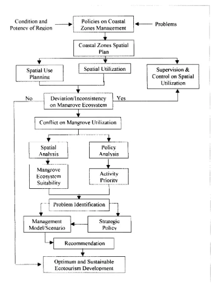
Coastal Zones Spatial
I'lanl
Condition and
Policies on Coastal
Potencv o f Region
-*I
Zones Management
Spatial Utilization
Problems
Control on Spatial
Utilization
I
I
Conflict on Mangrove Utilization
I
N o
Analvsis
Analvsis
Ecosystem
Activity
Suitability
Prioritv
Problem Identification
h
4
r I
Deviat ion/Inconsistency
on Mangrove Ecosvstem
Management
Strategic
ModeliScenario
*
Policv
Yes
1
[image:4.541.58.484.45.616.2]y
Recommendation
I
-I
Optimum and Sustainable
Ecotourism Development
Figure 1. Approach schematic diagram
Pesisir & Lautan
-- - - Volume 4, N O . ~ , 2002
(d
r
(d
Y
([I
7
C 0
.-
C
([I
0
0
Policy Analys~s of Coastal Ecotounsm Development..
.
. . . (9 - 24)-- - - -- - - - --
Data Collection
Data used in this research consisted of both primary and secondary data. T h e primary data was obtained directly from respondents through ques- tionnaires and direct interview, direct observation on research object, in order to havelobtain the real view of field condition.
Secondary data was obtained from literature study at related institutions. From the authority was obtained laws and regulations related to mangrove forest management. This data is needed to study the regulation or law or ordinance that controlled the duty, function and authority of each related in- stitutionlagency as well as policies issued by regional and central government.
1. Digital Data Processing
Data used in the preparation of the map ba- sically consisted of two categories: i.e. spatial data and alphanumeric data. T h e spatial data is the form of graphical chart whereas alphanumeric data is in table format. T h e spatial data used origi- nated from topographical map as the basic map, as well as thematic charts (e.g. land use map, in- clination map, elevation map, drainage, effective depth of soil, soil maps and water availability map, etc).
2.
Method for Respondent SelectionThe selection of respondent was carried out through purposive sampling, i.e. intentional selec- tion by considering the particular respondent as a land user (stakeholders). Respondents consisted of government, private sector and community groups, which affect the policy determination of suitability of mangrove ecosystem forest use either directly or indirectly in Jakarta Bay.
T h e selection of respondent in the A H P method is based on interviews activity using pre- pared questionnaires for 20 (twenty) respon- dents, consisted of officers working with the re- lated government officerlinstitutions or respon- dents that have specific knowledge (expert), di- rectly involved respondent or respondent that was considered as understanding the problem and has the ability to influence mangrove ecosystem of coast
i
Lone of Muara Angke.I'hese respondents were, a m o n g others Bappeda DKI Jakarta, Dinas Perikanan
DKI
Jakarta,BPN, Industrial and Trading Agency, Forestry, Civil W o r k s a n d A m e n i t i e s , T o u r i s m Agency, Enterpreneur, Fishery pond operators and commu- nity leaders.
Data Analysis
1.
Geographical Information System Method ApproachSpatial utilization of coastal zones was con- ducted based on developed principles, hence the spa- tial utilization has clear context in sustainable de- velopment terms. T h e principles are in space utili- zation that was used in conductingldetermining the zoning of an area according to the interest of vari- ous parties (stakeholders).
2.
Preparing the Hierarchy Structure (Preparing the Painvise Comparison Matrix and doing the Comparison)T h e painvise comparison matrix reflected the relative contribution or the effect of each element o n each objectivelcriteria, are level or above it. Comparison is conducted based on judgment by decision- maker by evaluating the importance level of one element against other element. T h e deter- mination of each hierarchy or opinion level is car- ried out by painvise comparison. T h e painvise com- parison technique used in A H P is based on judg- ment or opinion of decision maker
1
expert or non- expert but involved and understood the problems, selected as the respondent through direct interview and by comparing the importance of one element against the other.Evaluation is conducted through weighting for each component of the painvise comparison, start- ing from the highest level down to the lowest level. Weighting is based on the judgment or opinion of decision -makers or experts, by giving comparison score between
1
to9
(Saaty,1993).
3.
Conflict Analysis and Function and Authority AnalysisPesisir & Lautan Volume 4, No.2, 2002 with mangrove management and the function and
duties of the involved institutions.
T h e research uses the A H P approach in the planning and (;IS phases. Specific requirements and sequences are needed to analyze the situation by
AHP
approach, as follows:a. Defining the I'roblems and the Expected Solu- tion
A H P approach is intended to solve problems as well as finding the expected solution, i.e. deriv- ing an optimum scenario model, the involved aspectlproblems, executor as well as preparing a policy sequence that will be conducted.
b.
Comparison Matrix for HierarchyIn this research, a hierarchy comparison matrix was prepared for involved party or stakeholders who play dominant roles or has some priority role in the management.
GENERAL DESCRIPTION OF THE
AREA
Background
Muara Angke is the remaining mangrove for- est left in DKI Jakarta often forgotten by most people. The existence of Muara Angke mangrove forest helps community, especially citizen of Jakarta and its surrounding location to see and understand mangrove trees, complete with all wildlife living there. In addition, its location is not far from activ-
ity
centers (shopping centers and tourism, i.e. fish landing and marketing facility), close to Interna- tional Airport as well as bordering the classy hous- ing estate; all within easy reach by people.Muara Angke area, in the form of coastal man- grove forest is a forest zone at the North coastal area of DKI Jakarta. It has special characteristics as life supporting system. In this case, i t has functions as a buffer zone, presenting the intrusion of saline water in land areas; preventing sea wave abrasion with its physical protection capacity; as fishery habi- tat as well as various kind of birds and wildlife, also as education area and as open green zone for the big city which contributes precious oxygen as well as natural recreation areas.
Due to the unique condition of mangroves, the biological diversity contained in it and its stra- tegic location had made Muara Angke highly suit- able to be developed for limited ecotourism resort.
T h e availability of Muara Angke as tourism resort with emphasis an education is perceived positively and enthusiastically by the community. This can be proven by the record of community visiting the area as well as the unrecorded visitors, especially during the weeks ends.
Economics
Neither kelurahan had significant difference in the composition of occupation or livelihood. However, for the farmerlfishermen sector, the larg- est domination occurred in Kelurahan Kapuk Muara. T h e labour/worker sector at both kelurahans are significantly greater than other kind of occupa- tion.
Culture
Most of the population are Moslem. At Kelurahan Kana1 Muara and Kelurahan Kapuk Muara the moslem population is respectively 95.2 % and 82.8 %.
Spatial Use of Land
T h e land utilization at Kelurahan Kapuk Muara are 23.2 O/o (Agriculture), 50.0 O/o (Indus-
trial),
53.8
% (housing settlement),3.1
% (Of- fices),0.6
% (Trading), and 14.3 % for others. The Kelurahan Kapuk Muara is divided into 52.0 O/o(Agriculture),
43.87
% (Officer, housing and trading) and other (4.13 %).RESULTS
AND DISCUSSION
The Interest of Surrounding Community
Muara Angke belongs to one of estuary zones that is quite big and busy. T h e surrounding estua- rine areas are densely populated with all social classes, from the low economic income up to the richest community.
Policy Analysis of Coastal Ecotourism Development.. . . . (9
-
24)-- - - - -
munity leaders, it can be deduced that the commu- nity didn't have any objection to appropriate area development, such as site development for tour- ism.
Supply (Potency) and Demand Analysis
(Demand on Conservation Function of Muara Angke)
Supply (Potency) Analysis of Muara Angke
Studies on Muara Angke and the surrounding areas looked at the zone's potency in an effort to meet the demand, expected in the objective of the management. This is classified into two groups, as follows:
A.
The Internal Potency of the Muara Angke A couple of parameters showed that Muara Angke still deserve to be maintained conservation zone, such as:1. Bio-diversity
The potency of flora diversity is based around 42 species, consisting of mangrove (Rhizophora sp., Avicennia marina, Sonneratia caseolaris, Bruguiera gymnorrhiza, Nypa JFucticans, Excoecaria agallocha etc) , coastal vegetation ( Terminallid catappa, Hibis- cus tilliaceus, Casuarina equisetZfolia etc), swamp veg- etation (Eichornia crassipes, Andropogun nardus, Ip- omea sp etc), and dry land vegetation (Calamus sp., Acacia auriculiformis, Imperata cylindrica etc)
.
The fauna diversity (i.e. mammals) covered 54 individuals of long tailed monkeys (Macaca fdscicularis), otter (Aonixcinerea), and rats. Reptiles were represented by 7 species (caymam, boa, slate colored snake, cobra, badut snake, ring snake and green snake). There were 11 species of fish (gabus, sepat jawa, sepat rawa, betok, gapi, keting, kipper, pepetek, julung-julung, kepala timah and nila).
2.
The Naturalness of EcosystemWhen the Dutch Government issued the de- cree, the status of forest at Muara Angke as a sanc- tuary zone, the delta of Angke River consisted of mangrove forest dominated by paddy vegetation (Sonneratia caseolaris). Development and subse- quent effects of surrounding environment had caused environmental changes on the forest ecosys- tem of Muara Angke.
3.
Recreation Activity (Demand Analysis) in Muara Angke(a) General tower
(b) Photography hunting (c) Bird watching
(d) Hiking and walk inside the mangrove forest (board walk)
(e) Fishing
(f) Introduction to the culture of Muara Angke community
B. External Potency of Muara Angke Area 1. Dunia Fantasi (Dufan) Ancol
2. Marine Tourism (Ocean Harbor, TPI Kapuk, Bi- valve Aquaculture, Rambut Island, Untung Jawa Island, Pari Island Resort and Bidadari Island Resort)
3. Shopping Center (Mangga Dua, Glodok, Mega Mall Pluit, PIK Mall)
4. Sport Facility (PIK Golf Course)
5. Protected Forest at Muara Angke, Toursim Fo- rest, Mangrove Nursery
Government Policy
The government policy in relation to the pres- ervation of the conservation area and Muara Angke site can be studied from a couple of policies, either at National, sector or regional levels. At the Na- tional and Sectoral levels (i.e. the form of law, regu- lation (PP & Keppres)), the commitment of Go1 (Government of Indonesia) to maintain and pre- serve the conservation areas is still high. This is re- flected in law no. 2411992 (spatial use), law no. 231 1997 (Management of Environment), and law no. 4111999 (Forestry). Law no. 511990 (The Conservation of Natural Biodiversity and its eco- system), law no. 221 1999 (Regional Governance), as well as Keppres (Presidential Decree) no. 321 1990 (The Management of Protected Zones) and PP (Government Regulation) no. 281 1985 (Forest Pro- tection) PP no. 2011930 (Standard of Water Qua- lity) etc.
Pesisir & Lautan Volume - 4, No.2, 2002
-- -
ter the reclamation. The direction of spatial use pattern of protected zones stated that the manage- ment of ~ r o t e c t e d zones is for the improvement of protection function for the region as well as the protection of air quality and microclimate.
The Management of Muara Angke Wildlife Sanctuary
Technically, the management of Muara Angke is under the working area of Natural Resources Conservation Agency, of Provincial Office of Min- istry for Forest and Crop Estate of DKI Jakarta. In conducting the management, the conservation site is directly under the coordination of Natural Re- sources Conservation Agency (BKSDA), i.e. under the conservation section. Within the conservation section there is the subsection for Eastern Jakarta Area, which directly conducts the management and control on the site, helped by administration per- sonals, forest wardens, and functional officers for exclusion services. In order to conduct daily opera- tion, BKSDA assigned one field officer stationed at the conservation site with the main job to con- trol and guard the site.
Conflict on Space Utilization
Space utilization for certain development ac- tivity constitutes highly important decision mak- ing, especially if related with environment, social, economic, living environment and technology fac- tors. The reasons were that determining what is car- ried out by people on the land where people are inseparable part of it is a d e m a n d i n g task. Ecotourism pattern in a region is a containment of human activity according to the level of technol- ogy, physical condition, kind of works, magnitude and the interest of people living in that region.
Indonesia has laws and regulations concern- ing land tenure, rights and utilization. However, during the implementation deviations always oc- cur, e.g. deviating from the valid RUTR (Spatial Use Plan). Therefore, it is potentially easy to in- duce the development of spatial use conflict, such as that happened in: (1) Jakarta Bay i.e. conflict on spatial use plan between industrial and mangrove ecosystem purposes. The spatial use plan assigned the zone for mangrove fishery, while the results on land suitability analysis, both location are suitable for mangrove ecosystem. (2) Muara Angke, i.e. con- flict between industrial, mangrove ecosystem and settlement purposes, where these three purposes cannot exist together simultaneously, because each activity imposed negative impact to the other.
Conflict between Industry, Mangrove Ecosystem, Natural Conservation and Protection Area, and Research and Natural Laboratory
AHP procedure is carried out on conflict be- tween industry and mangrove ecosystem at Jakarta Bay. Based on judgment from stakeholders cover- ing the government, private sectors and commu- nity, the Consistency Ratio (CR) was obtained, ranging between 0.01 to 0.08, i.e. still under
CR
=0.10. Therefore, it was concluded that the stake- holders were consistent in providing the weighting score with small deviation level.
a). Combined Opinion in Ecotourism Development Priority
Results of analysis on combined opinion in ecotourism development priority determination for each stakeholder involved in the present conflict, are shown in Table 1, 2,
3
as follows:Table 1. Results of Analysis or GroupICombined Opinion on Priority Determination for Each Stakeholder. Stakeholders
Policy for Ecotourism
- - -
-..--
--- - - -Industrial
Policy Analysis of Coastal Ecotourism Development.. . . . (9 - 24)
- - -
T h e results of analysis presented in the Table was area availability with weighting score =
0.225,
1, 2,
and3
on priority determination activity ac- and pollution with weighting score =0.16
1. There- cording to government's perception, was the first fore, the government's perception in the first prior- priority went for mangrove ecosystem with weight- ity determination was for mangrove ecosystem pro- ing score =0.543
and if looked at from the upper tection purposes based on environment and social hierarchy (level3 ) ,
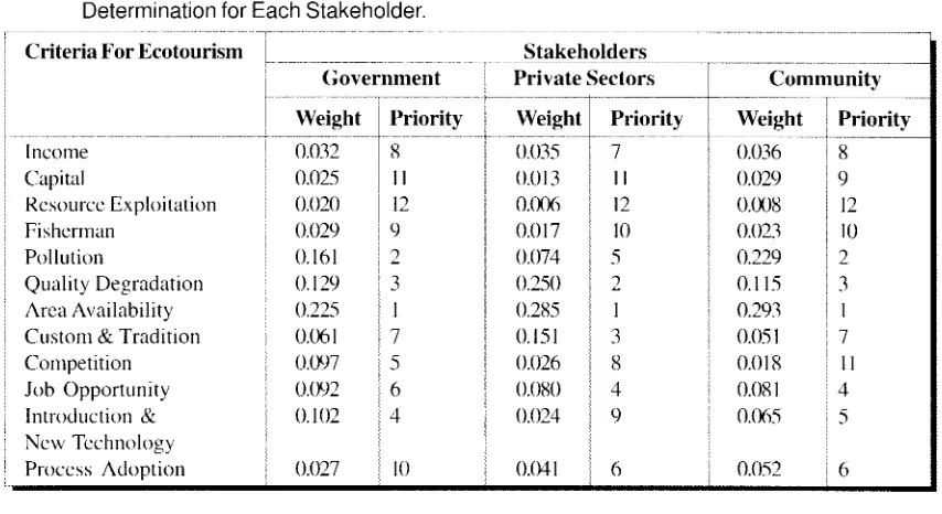
then the highest weight factor consideration.Table 2. Results of Hierarchy Level -3 Analysis on Opinion Against Influential Factors in Priority Determination for Each Stakeholder.
Criteria For Ecotourism - - --- - -- Stakeholders
Government Private Sectors
Income Capital Resource Exploitation Fisherman Pollution Quality Degradation Area Availability Custom & Tradition Cornpetition Job Opportunity Introduction &
New Technology Process Adoption
Weight
0.032 0.025 0.020 0.029 0.16 1
0.129 0.225
0.06 1
0.097 0.092 0.102 0.027 Priority 8
I I 12 9 2 3 1 7 5 6 4 10 Weight --- - 0.035 0.0 1 3 0.006 0.0 17 0.074 0.250 0.285 0.151 0.026 0.080 0.024 0.04 1 Priority -. - 7 I I 12 10 5 2 1 3 X 4 9 6 Community Weight - -- 0.036 0.029 0.008 0.023 0.229 0.1 15 0.293 0.05 1
0.018 0.08 1
0.065 Priority --- 8 9 12 10 2 3 1 7
[image:10.541.57.484.174.407.2]I I 4 5
Table 3. Results on Opinion Analysis on Aspect Consideration in Priority Determination for Each Stakeholder.
Aspect for Ecotourism
i
StakeholdersIndustry Environment Social Technology
I
GovernmentWeight - 0.106 0.5 16 0.249 0.129 Priority
Private Sectors Community
Weight 0.096 0.637 0.1 50 0.1 17 Priority - -- 3
Rased on the private sector's perception, the first priority went for mangrove ecosystem with weighting score =
0.571,
which is looked from the upper level3
then the highest weighting factor was the area availability with weighting score =0.285
and quality degradation with weighting score =0.250.
Therefore, the perception of private sector in deter- mining the first priority was also for mangrove eco- system protection purposes, based on social aspects and environmental considerations.
T h e perception of con~munity put the first priority for mangrove ecosystem with weighting score =
0.576.
Looked from one level up hierarchy (level3 ) ,
the highest weighting factor was also areaavailability practiced For generations with weight- ing score =
0.293,
and pollution with weighting score =0.229.
Hence, the community perceptionin determination of first priority was for mangrove ecosystem protection based on social-environmen- tal consideration.
b).The Structure of First and Second Hierarchy
T h e results on research o n consideration as- pect and results ofanalysis on affecting factors against the ecotourism development priority determination were presented in Tables
4,
5,
and6 .
[image:10.541.65.490.430.551.2]Peslslr & Lautan
-- - - -- - - - Volume 4, No.2, 2002 - -
-purposes then the environment aspect consideration was the most dominating with weighting score =
0.561 and factors which highly influencing these aspects in relation with land utilization for man- grove ecosystem in subsequent order was area avail- ability as first priority with weighting score =0.252. The existence of mangrove ecosystem in this re- gion can increase the original regional as well as lo- cal community's earnings. T h e second priority was pollution with weighting score = 0.164. There are
a couple of matters that need further study: At first,
it was expected that the ecotourism development expected will be able to employ the local work force. In reality, the job opportunity employment fell into the fourth priority. D u e to fact that the local workforce lacked the needed skill, many of the em- ployed are skilled labor from other regions.
From the results from the union of all respon- dents opinion analysis described in Tables
4,
5, and6
for mangrove ecosystem issues, it can be con- cluded that the environment consideration hold first priority with weighting score = 0.561. This was influenced heavily by area availability factor. There was passed from one generation to the next (weight- ing score = 0.252. This can be explained by factthat most of the land utilized for mangrove ecosys- tem is inherited property from their ancestors. T h e second priority a n d t h e t h i r d priority was community's pollution and quality degradation with weighting score
=O.
164 and weighting score =0.146. The fourth priority was job opportunity ab- sorption with weighting score =
0.087.
T h e reason was that local workforce has the skills and expertise for that purpose.c).The Third and Fourth Hierarchy Structure Based on the results of hierarchy analysis on the union of all respondents opinion in ecotourism development conflict between industry, mangrove ecosystem, natural conservation and protection area, and research and natural laboratory at Muara Angke placed more importance on mangrove ecosystem pur- pose with weighting score =0.555 than consideration on environmental aspect with weighting score = 0.56
1.
The second aspect was social aspect with weighting score = 0.226 and the third aspect, which is also influ- ential, was technology aspect. i.e.: Introduction to new technology and process adoption. This shows that mangrove ecosystem development in study area whichhas pollution potency must have waste treatment man- agement (either solid, liquid or gaseous waste) before discharging to river or sea.
T h e results o f h i e r a r c h y analysis, o n ecotourism development priority determination in spatial use of coastal zone are presented in Figure
2.
Policy Analysis
I n relation t o the results of analysis o n ecotourism development conflict in spatial use of coastal zone that occurred in Jakarta Bay, i.e. con- flict between industrial and mangrove ecosystem purposes, then based on hierarchy analysis result it can be said that the location priority was for man- grove ecosystem purposes. Whereas the land suit- ability evaluation stated that the location was actu- ally suitable for both intentions. Factors that aroused the conflict on the location were due to land utilization that not in accordance with direc- tion stated in the spatial use plan for land being suitable for mangrove ecosystem construction. Based on results of hierarchy analysis and evalua- tion as well as considering the direction stated in spatial use plan 2000 that was not suitable anymore with industry development situation, then the de- termination of ecotourism development for man- grove ecosystem purposes can be recommended as the foundation for decision making in determin- ing the policy to solve the conflict occurring in Muara Angke in Jakarta Bay.
A
Similar finding was made for conflict in ecotourism development in spatial use of coastal zone that occurred at Muara Angke i.e. conflict between industry, mangrove ecosystem, natural conservation and protection area, and research and natural labora- tory, based on results of hierarchy-2 analysis. The pri-' ority of the location w d t for first priority for man- grove ecosystem and thesecond priority for natural conservation and protection area. Because both activ- ity has the relatively same level of interest for the Gov- ernment, private sector and community. i.e. the dif- ferences in weighting score were small. The next pri- ority went for industry and then research.Table 4. The Result of the Union of All Respondents Opinion Analysis on Aspect Consideration of Coastal Ecotourism Development Priority Determination.
Social
Table 5. The Result of the Union of All Respondents for Hierarchy Level-2 Analysis on Opinion Against Influential Factors in Coastal Ecotourism Development Prioritv Determination
TOTAL 0.40 1 0.288 0.689 0.308 1.963 1.750 3.020 0.881 0.788 1.043 0.957 0.430
WEIGHT 0.033 0.024 0.0 15 0.026 0.164 0.146 0.252 0.073 0.066 0.087 0.080 0.036
PRIORITY
Income Capital
Resources Exploitation Fisherman
Pollution
Quality Degradation Area Availability Custom & Tradition Competition Job Opportunity
Introduction Technology Process Adoption
Table 6. The Result of the Union of All Respondents Opinion Analysis on Priority Consideration of Coastal Ecotourism Development Priority Determination
/
POLICY l R 1I = I
R3 TOTAL PRIORITYIndustry
Mangrove Ecosystem Conservation & Protection Research
0.126 0.577 0.181 0.116
0.123 0.543 0.206 0.129
[image:12.825.47.779.50.142.2] [image:12.825.45.789.162.379.2]PRIORITY DETERMINATION &
ACTIVITY (SPATIAL USE)
Income Capital Resources Fisherman (0.033) (0.024) Exploitation (0.026)
(0.0 15)
I ECONOMIC
(0.098)
.
Competition
Tradition (0.066) Opportunity
I I I
Pollution Quality Area Introduction & Process
Degradation Availability New Technology Adoption
CONSERVATION &
I
1
1
1
ENVIRONMENT (0.561)
2. Result of Analytical Hierarchy Process
PROTECTION ZONES LABORATORY
(0.1 94) (0.122)
...
SOCIAL (0.226)
Policy Analysis of Coastal Ecotourism Development.. . . - -- - - land utilization for industry, which was not follow- ing the direction mentioned in the spatial use plan. Land was therefore allocated for fishponds and hous- ing/ settlement in anticipation of the regional de- velopment direction.
Based on the result of research, subsequent dis- cussion and field study conducted, it can be con- cluded that the optimal maintained forest area was
327.70
Ha. The assignment and function ofJakarta Bay Forest zone is as follows:* Protected Forest =
44.76
H a * Tourism Forest =99.82
I1a* Muara Angke Natural Sanctuary =
25.02
Ha * Forest for Special Intention (LTDI)Forestry Nursery =
10.51
HaP1,N's Transmission Path =
23.07
HaCengkareng Drain =
28.73
H a * Toll Road and Green Belt =75.50
HaCONCLUSION AND RECOMMENDATION
Conclusion
? 7
I he ecosystem of mangrove forest at Muara Angke is an integral part of Jakarta Bay and the surrounding environment. Almost all activity, de- velopment, social, economic, cultural and especially physical development activity is related closely with the bay's environment. Therefore, the mangrove forest resources of the bay function as a vital com- ponent of the natural environmental balance and needs to be guarded and maintained from degrada- tion and destruction.
All
along the northern coast of what now is DKI Jakarta was originally mangrove forest ecosys- tem, complete with all richness of bio diversity con- tained in it. However, nowadays, the remaining forested areas can only can be found at the Muara Angke forest zone(327.70
Ha). Forests where the condition is reasonably good and the management status still provide quite high protection values are the protected forest(50.8
Ha) and the Muara Angke Sanctuary (25.02 Ha).Each zone of Muara Angke has its own po- tency for ecotourism, such as:
* The unique and beautihl of scenery at Jakarta Bay * The diversity ofvegetation wildlife and mangrove
waters biota
. . . (9 - 24)
* The specific features of local community's cul- ture.
In addition, the position of DKI Jakarta as the capital of Indonesia and the gateway for all state guests, then the existence of Muara h g k e forest zones, which also represent the original mangrove ecosystem in DKI Jakarta, the forested areas are of Muara Angke is highly important to be maintained and preserved for future generation to come and for National pride.
Based on the above potency, then the oppor- tunity to develop ecotourism in this mangrove for- est is very high. Ecotourism is one form of recre- ation, which relies heavily on the beauty and rich- ness of nature. Based o n spatial allocation, ecotourism activities which can be adopted or ac- commodated are divided into two parts, i.e.:
1 . Scientific tour activity, this is one kind of ecotourism activities which was intended to pro- vided or to improve knowledge on the whole aspect of mangrove in the Muara Angke, con- sisting o f :
a) Introduction to the mangrove vegetation, one kind of ecotourism which will provided scientific information to the visitor on: * Habitat of mangrove vegetation
* Observation on the structure of mangrove vegetation
* Species identification of mangrove vegetation
b) Introduction to wild life (learning to know the wild life) is a challenging activity and requires patience, because wild life is mobile or moving around.
C) Research is a useful and beneficial activity for
education as well as the development of science. The activity consisted of works such as research related with mangrove ecosystem and watershed ecosystem management; the re search work can be suspected on perfected zones and mangrove waters.
2.
Recreational activity, with the purpose to obtain enjoyment and providing first hand experience to the visitor; this consist o f :* General tourlsight seeing
* Photography hunting
Pesisir & Lautan
-- - - Volume 4, No.2, 2002
* Board walk experience
* Fishing sports
* Cultural introduction to the local community All the above works can be implemented o n both mangrove forest ecotourism zones and man- grove waters ecotourism zones. If these ideas are implemented, they will need an ecotourism devel- opment plan which is based o n the principal of en- vironmental conservation. T h e physical develop- ment concept is environmentally friendly planning and construction, with basic facility construction that will ensure the safety and comfort of visitors, e.g. protection against weather, good air circulation, clean etc.
Another opportunity that will be able to ac- commodate special scientific activity, e.g. research and development studies, is the protected mangrove zones and protected water zones. More common scientific research (i.e. introduction or identifica- tion of vegetation and wild life) and recreational activities can be conducted in the mangrove ecotourism zones and mangrove waters ecotourism zones.
The less productive fishery pond can be re- claimed and converted into community settlement; whereas the productive fish ponds and located close to mangrove zones can be maintained and devel- oped as a tourism attraction of silvo-fishery con- cept.
The perception of government and private sec- tors on coastal zone spatial use at
DKI
Jakarta, was focused more or mangrove ecosystem based on en- vironment consideration. Whereas the perception of the community was dominant on fishery activ- ity by sociological aspect consideration, i.e. the fish ponds business had been traditionally carried out for generations.Considering the results from ecotourism de- velopment, the results from Analytical Hierarchy Process and the available Spatial Use Plan, as well as present condition of regional development then in order to solve the conflict at the Jakarta Ray. It was recommended as mangrove forest zones, be-
cause the surrounding industry was not productive. Therefore, the land can be converted to forest.
Recommendation
In order to recover the lost environmental function due to reduction of conservation zones area, mangroves replanting activity should be car- ried out. Although the surface area of the replace- ment was not as vast as the original zones, at least this effort can improve the environmental quality of the surroundings.
Based o n results of hierarchy analysis and evalu- ation as well as considering the direction stated in the spatial use plan
2000,
then the decision to uti- lize the land for mangrove and fishery ponds can be recommended as the foundation for decision mak- ing in determining the policy for solving the con- flict occurred at Muara Angke, this also matches results of the land suitability analysis.This research can be extended further, by in depth research on economic values which can be contributed by mangrove forest ecosystem, either direct economic values (from revenue from entry payment to the recreational forest) or the indirect value (the contributed ecological values).
Government of Indonesia should ascertain the laws, especially spatial use law(s) which is clear, bounding and has powerful impact, hence any land that already has clear assignment canlnot be replaced or its function change.
A revision should be conducted o n the spatial use plan because the present spatial use plan was irrelevant or incompetent in terms of the present condition and regional development. Communi- ties that suffered impact from the development oc- curred on the area should be relocated to a much better location.
Pol~cy Analysis of Coastal Ecotourism Development..
. .
- -- p-pppp -
REFERENCES
Aksornkoe, S., 1995. Ecology and Biodiversity ofMangroves. Proceeding of Ecology and Management ofMangrove Re- forestation and Regeneration in East and Southeast Asia. Thailand, 18 - 22 January: 20-36.
Quarto A, 2001. About the Mangrove Action Project. PO. Box 1854 Port Angeles, WA 98362-0279 USA. Website:
http:llwww.earthisIand.org/map/index.htm
Anonym, 1997. Mangrove Forest. http://www.magrove-Eorgl
mangrove. htm
Anwar and Subiandono, 1997. Technical Guidelines ofMan- grove Planting. Cooperation between Research and De- velopment Center of Forest and Natural Conservation in Bogor and Surakarta, Indonesia.
Bengen, D.G., 1998. Metodologi Riset Sumberdaya Pesisir dan Lautan. Program Stiidi Pengelolaan Sumberdaya Pesisir dan Lautan, Pasca Sarjana, Institut Perranian Bogor. Bengen, D.G, 2001. Pedoman Teknis Pengenalan dan
Pengelolaan Ekosistem Mangrove. Pusat Kajian Sumberdaya Pesisir dan Lautan, IPB Bogor.
BPP Teknologi, 1998. Remote Sensing and Geographic Infor- mation System, YearBook 97/98. Jakarta.
Butter, R. W., 1991. Toursim, Environment, and Sustainable Development Environmental Conservation, 18(3), 20 1 -
207.
Chrisman, N., 1997. Exploring Geographic Information Sys- tem. John Wiley & Sons, University ofwashington. Clark, J., 1996. Coastal Zone Management Hand Book. CRC
Lewis, New York.
Dahuri, R., 199 1. An Approach to Coastal Resources Utiliza- tion: The Nature and Role of Sustainable Development in East Kalimantan Coastal Zone, Indonesia. Ph.D. Disserta- tion, Dalhousie University, Halifax, Canada.
Dahuri, R., J. Rais, S.P Ginting, and M.J. Sitepu., 1996. Inte- grated Coastal and Marine Resource Management. Pradnya Paramita, Jakarta.
Management and Utilisation ofMangrove in Asia and the Pasific. F A 0 Environment Paper 3, Rome, Italy.
FAO, 1993. Integrated Management of Coastal Zones. F A 0 FisheriesTechnical Paper NR. 327, Rome, Italy.
FAO, 1994. Mangrove Forest Management Guidelines. F A 0 Forestry Paper No. 117, Rome, Italy.
Field, B. C., 1994. Environmental Economics: An Introduc- tion. Mc Graw-Hill, USA.
Haryadi T., dan W. Wishnu, (1995). Konservasi Air tanah di Wilayah DKI Jakarta - Tangerang. Direktorat Geologi Tata Lingkungan, Bandung - Indonesia (unpublished). Hehanussa, P E., S. Hadiwisastra and S. Djoehanah 1975.
Sedimentasi delta baru Cimanuk. Geol. Indon. 3 (1):21 -
35.
Hunt, L.J., 1999. Integrated Coastal Zone Planning and Man- agement Manual. Vaughan International. Canora Asia Incoporated Group of Companies. Canada.
Kjerfe, B., 1990. Manual for Investigation of Hydrological Processes in Mangrove Ecosystem. UNESCO/UNDP Regional Project.
Martosubroto,
I?
and N. Naamin, 1978. Relationship between Tidal Forests (mangrove) and Commercial Shrimp Pro- duction in Indonesia. Marine Fisheries Research Institute,18: 81-86.
Ministry for Environment, 1999. Agenda 21 Indonesia: Na- tional Strategy for Sustainable Development. Ministry for Environment/UNDP, Jakarta.
National Research Council, 1995. Science, Policy and the Coast: Improving Decision-Making, National Academy Press, Washington DC.
Saaty, T.L., 1993. Pengambilan Keputusan Bagi Para Pemimpin (Proses Hirarki Analitik untuk Pengambilan Keputusan dalam Situasi Kompleks). Terjemahan. PT. Pustaka Binawan Pressindo, Jakarta.
Spalding, M.D., F. Blasco and C.D. Field, 1997. World Man- grove Atlas. The International Society for Mangrove Eco- system, Okinawa, Japan.