A COMPARATIVE STUDY ON THE PERCEPTION OF
FOREST LANDSCAPE USING
LIST
METHOD BETWEEN
UNIVERSITY STUDENTS OF JAPAN AND INDONESIA
PRITA INDAH PRATIWI
GRADUATE SCHOOL
BOGOR AGRICULTURAL UNIVERSITY BOGOR
STATEMENT OF THESIS AND SOURCES OF
INFORMATION AND COPYRIGHT DELEGATION*
I hereby declare that the thesis entitled Comparative Study on the Perception of Forest Landscape Using LIST Method between University Students of Japan and Indonesia is my original work with the guidance of the supervisor commission and has not been submitted in any form to any university. The source derived or cited from published and unpublished works from the other writers has been mentioned in the text and listed in the references at the end of this thesis.
I hereby assign the copyright of my paper to Bogor Agricultural University.
Bogor, June 2014
Prita Indah Pratiwi
NIM A451110171
______________________________________________________________
SUMMARY
PRITA INDAH PRATIWI. Comparative Study on the Perception of Forest Landscape Using LIST Method between University Students of Japan and Indonesia. Supervised by BAMBANG SULISTYANTARA and ANDI GUNAWAN.
Forest is not only assessed for timber production, but also for public interests. It is not easy to measure the multiple functions and existence values which forests represent to local residents. People’s environmental perception, experience and attitudes could influence their affinity and preference to the local landscapes (Hanley et al. 2009; Kaltenborn & Bjerke 2002). Recently, some studies have focused on the influence of specific nature images on landscape preferences (Ribe 2002; Van den Berg & Koole 2006). The methodology using visual stimuli on landscapes photographs is still based on normative ways of seeing the landscape in western countries, while landscape visual evaluation in non-western countries is rarely investigated. Based on previous research regarding landscape preference (Pratiwi 2013), both students of Japan and Indonesia distinguished their landscape preference into 25 photos of lake, river, wetland, and forest landscape, meanwhile, their landscape exoticism was put into 48 photos of various landscape types. By externalizing landscape image directly as visual information, the variation of students’ perception could be understood that it might encourage the preference differences in the way of seeing the landscape. Because there were differences in perception of seeing landscapes, it was necessary to classify landscape image aspects of Japanese and Indonesian students using LIST, to study internal factors that influence the perception, and to formulate the differences of forest landscape characters.
The study was conducted in three stages, namely, 1) landscape image survey, 2) landscape image analysis, and 3) forest landscape interpretation. LIST method was applied to classify landscape image aspects. Chi-square test was applied to examine the significant differences between students of Japan and Indonesia in perceiveing forest landscape, while cluster analysis was applied to characterize forest landscape. The results showed that 10 prominent components were detected in both countries. In landscape image of Japan, prominent components were identified by trails, people, needle leaf forest, surrounding place, and recreational space. In landscape image of Indonesia, prominent components were identified by understory plant, broadleaf forest, sideways view, forest structure, and scenic view. Factors influencing perception consisted of gender, age, past landscape type, present landscape type, past urbanization level, present urbanization level, and experience of journey. The only attribute influencing perception for Indonesian students was gender. Japanese students distinguished forest type into needle leaf, broadleaf and unknown forest type, while Indonesian students distinguished forest type into broadleaf and unknown forest type. The result of this study might be useful as guidance for forest landscape design in Japan and Indonesia.
RINGKASAN
PRITA INDAH PRATIWI. Studi Perbandingan Persepsi pada Lanskap Hutan Menggunakan Metode LIST antara Pelajar Jepang dan Indonesia. Dibimbing oleh BAMBANG SULISTYANTARA dan ANDI GUNAWAN.
Hutan tidak hanya dinilai untuk produksi kayu saja, tetapi juga untuk kepentingan umum. Ini tidak mudah untuk mengukur beragam fungsi dan nilai-nilai eksistensi yang hutan berikan bagi penduduk lokal. Persepsi lingkungan, pengalaman, dan sikap manusia dapat mempengaruhi afinitas dan preferensi mereka terhadap lanskap lokal (Hanley et al. 2009; Kaltenborn & Bjerke 2002). Akhir-akhir ini, beberapa penelitian telah berpusat pada pengaruh gambar alam tertentu terhadap preferensi lanskap (Ribe 2002; Van den Berg & Koole 2006). Metodologi menggunakan rangsangan visual pada lanskap foto masih didasarkan pada cara-cara normatif dalam melihat lanskap di negara-negara barat, sedangkan evaluasi lanskap visual di negara-negara non-barat jarang diselidiki. Berdasarkan penelitian sebelumnya mengenai preferensi lanskap (Pratiwi 2013), pelajar Jepang dan Indonesia membedakan preferensi lanskap ke dalam 25 foto lanskap danau, sungai, lahan basah, dan hutan, sementara itu, eksotisme lanskap dimasukkan ke dalam 48 foto berbagai jenis lanskap. Dengan mewujudkan gambar lanskap secara langsung sebagai informasi visual, variasi persepsi pelajar dapat dipahami bahwa hal ini dapat mendorong perbedaan preferensi dalam cara melihat pemandangan. Karena terdapat perbedaan persepsi melihat lanskap, hal ini dianggap perlu untuk mengklasifikasikan aspek gambar lanskap dari pelajar Jepang dan Indonesia menggunakan LIST, untuk mempelajari faktor-faktor internal yang mempengaruhi persepsi, dan merumuskan perbedaan-perbedaan karakter lanskap hutan.
Penelitian dilakukan dalam tiga tahap, yaitu 1) survei gambar lanskap, 2) analisis gambar lanskap, dan 3) interpretasi lanskap hutan. Metode LIST diterapkan untuk mengklasifikasikan aspek gambar lanskap. Uji Khi-kuadrat digunakan untuk menguji perbedaan yang signifikan antara pelajar Jepang dan Indonesia dalam mempersepsikan lanskap hutan, sedangkan analisis gerombol digunakan untuk mengkarakterisasi lanskap hutan. Hasil penelitian menunjukkan bahwa 10 komponen penting terdeteksi di kedua negara. Pada gambar lanskap Jepang, komponen penting diidentifikasi oleh jalan setapak, orang, hutan berdaun jarum, surrounding place, dan ruang rekreasi. Pada gambar lanskap Indonesia, komponen penting diidentifikasi oleh tanaman understory, hutan berdaun lebar,
sideway view, struktur hutan, dan scenic view. Faktor-faktor yang mempengaruhi persepsi terdiri atas jenis kelamin, usia, tipe lanskap masa lalu, tipe lanskap sekarang, tingkat urbanisasi masa lalu, tingkat urbanisasi sekarang, dan pengalaman perjalanan. Satu-satunya atribut yang mempengaruhi persepsi bagi pelajar Indonesia adalah jenis kelamin. Pelajar Jepang membedakan jenis hutan ke dalam daun jarum, berdaun lebar, dan unknown forest, sedangkan pelajar Indonesia membedakan jenis hutan menjadi berdaun lebar dan unknown forest. Hasil penelitian ini dapat berguna sebagai pedoman untuk desain lanskap hutan di Jepang dan Indonesia.
© Copyright belongs to IPB, 2014
All Rights Reserved
Prohibited to cite a part or all of this paper without including or citing sources. Citation is only for educational purpose, research, scientific writing, preparation of reports, criticism writing, or review of matter; and citation does not harm to the interests of IPB
A COMPARATIVE STUDY ON THE PERCEPTION OF
FOREST LANDSCAPE USING
LIST
METHOD BETWEEN
UNIVERSITY STUDENTS OF JAPAN AND INDONESIA
GRADUATE SCHOOL
BOGOR AGRICULTURAL UNIVERSITY BOGOR
2014
PRITA INDAH PRATIWI
Thesis
as a requirement to obtain degree Master of Science
in
Title of Thesis : A Comparative Study on the Perception of Forest Landscape Using LIST Method between
University Students of Japan and Indonesia
Name : Prita Indah Pratiwi
Index Number : A451110171
Approved by Supervisor Commission
Dr Ir Bambang Sulistyantara, MAgr Chairman
Dr Ir Andi Gunawan, MAgrSc Member
Known by
Head of Landscape Architecture Program
Dr Ir Nizar Nasrullah, MAgr
Dean of Graduate School
Dr Ir Dahrul Syah, MScAgr
Date of Defense:
FOREWORD
First, the author gives the praise and gratitude to Allah for all his gifts, thus the thesis entitled A Comparative Study on the Perception of Forest Landscape Using LIST Method between University Students of Japan and Indonesia could be completed. Landscape image sketches revealed different way of seeing landscape between respondents in Japan and Indonesia through individual perception. This methodology could be useful in understanding different assumptions regarding environmental issues, not only for a global environmental discussion, but also for local environmental planning and design through public participation.
The author thanks to:
1. Dr Ir Bambang Sulistyantara, MAgr and Dr Ir Andi Gunawan, MAgrSc as supervisor at Bogor Agricultural University for the great advice and guidance in completion of this thesis.
2. Katsunori Furuya PhD as supervisor at Chiba University for the kind support in this intercultural research of landscape preference and perception.
3. Dr Ir Aris Munandar, MS as the examiner of external commission for the suggestion and additional input of this thesis
4. Dr Ir Nizar Nasrullah, MAgr as the head of Landscape Architecture Program for the motivation and advice in completion of this thesis
5. Dr Bagus Sartono, SSi, MSi for the help and guidance in statistical data interpretation
6. Parents, Ir Eddy Soliyadi and Ir Keni Kenranikanti, and little brother, Miladio Rizky Prabowo for the prayer, support, and big motivation.
7. Undergraduate and graduate students of Landscape Architecture Program at Bogor Agricultural University and Division of Environmental Science and Landscape Architecture at Chiba University as respondents and good friends for the help, support, and kindness.
Bogor, June 2014
CONTENTS
LIST OF TABLE vi
LIST OF FIGURE vi
LIST OF APPENDIX vii
1 PREFACE 1
Background 1
Formulation of Problem 2
Objectives of Research 3
Benefits of Research 3
Scope of Research 3
2 LITERATURE REVIEW 3
Perception and Preference 3
Fukei Theory 4
Landsape Image 5
Landscape Image Sketching Technique (LIST) 6
3 METHODS 7
Object and Time of Research 7
Data Collection and Sampling 8
Data Analysis Procedure 9
4 RESULTS AND DISCUSSION 14
Classification of Landscape Image Aspects 14
Factors Influencing Perception 25
Forest Landscape Characters 39
Guidance for Forest Landscape Design 42
5 CONCLUSION AND SUGGESTION 45
Conclusion 45
Suggestion 45
REFERENCES 46
APPENDIX 49
LIST OF TABLE
1 Students’ characteristics 7
2 3
Variables of landscape image Landscape element per country (%)
12 15
4 Forest types per country (%) 17
5 Spatial view per country (%) 18
6 Self-orientation per country (%) 20
7 Social meaning per country (%) 23
8 Prominent component of landscape image aspects 24
9 Japanese students’ attribute and linguistic knowledge 26 10 Indonesian students’ attributes and linguistic knowledge 28 11 Indonesian students’ attributes and spatial view 31
12 Japanese students’ attributes and spatial view 31
13 Japanese students’ attributes and self-orientation 32 14 Indonesian students’ attributes and self-orientation 34 15 Indonesian students’ attributes and social meaning 35 16 Japanese students’ attributes and social meaning 35
17 Prominent factors influencing perception 38
18 Forest landscape interpretation in Japan 43
19 Forest landscape interpretation in Indonesia 43
LIST OF FIGURE
Diagram of landscape image, its aspects and variables Diagram of framework
Classification of landscape element Landscape element per country Classification of forest type
11
Forest types per country Classification of spatial view Spatial view per country
Classification of self-orientation Self-orientation per country Classification of social meaning
17
Social meaning per country Students’ attributes per country
The percentage of students related to past landscape type in perceiving understory plant
23 25
26 20 The percentage of students related to past urbanization level in
21 The percentage of students related to gender in perceiving mixed
forest 28
22 The percentage of students related to present landscape type in
perceiving mixed forest 28
23 The percentage of students related to past urbanization level in
perceiving mixed forest 29
24 The percentage of students related to age in perceiving fallen trees 29 25 The percentage of students related to past landscape type in
perceiving understory plant 29
26 The percentage of students related to gender in perceiving terrain 30 27 The percentage of students related to present landscape type in
perceiving creature 30
28 The percentage of students related to present urbanization level in
perceiving creature and sky 30
29
30
The percentage of students related to past landscape type in perceiving sideway view
The percentage of students related to experience of journey in perceiving single object
32
33 31 The percentage of students related to age in perceiving scenic
place 33
32 The percentage of students related to past urbanization level in
perceiving scenic place 33
33 The percentage of students related to experience of journey in
perceiving objective scene 34
34
35
The percentage of students related to present landscape type in perceiving forest structure
The percentage of students related to past urbanization level in perceiving scenic view
The percentage of students related to present urbanization level in perceiving scenic view
The percentage of students related to age in perceiving scenic view The percentage of students related to past urbanization level in perceiving symbolic place
36 37
37
39 Dendogram of Japanese and Indonesian cluster 41
40 Forest landscape sketch of Indonesian cluster 41
41 Forest landscape sketch of Japanese cluster 42
LIST OF APPENDIX
1 Data attributes of respondents 49
2 Free association survey of landscape image sketches of forest in
Japan and Indonesia 51
3 The result of Chi-square test using SPSS 16.0 56
1 PREFACE
Background
In the recent years, the world’s forests have been affected by over -harvesting, over-grazing, pests and diseases, high global temperatures, floods, droughts, storms, air pollution and forest fires, as well as economic crisis in Asia and other regions leading to an overall decrease in the world’s forest cover. The forests in Asia in particular have been strongly affected (Inoue 2003). A number of initiatives have suggested forest policy reforms and the need for the sustainable forest management has been widely recognized and encouraged. As Schmithüsen (1995) described, the lack of consensus on a balance among global, national and local demands becomes a major obstacle for the advancement of international cooperation in forest policy. Local socio-cultural background is often ignored by global discussion (Rannikko 1999; Marsden 2003; Finger-stich 2005). Whereas in the interest of sustainable forest management, forest is no longer assessed only for timber production, but also for public interests (Kleim and Wolf, 2007), such as amenity, tourism, conservation, even nature’s health service (Knight 2000; Li et al.
2006)
It is crucial that peope effectively participate in forest planning and management to measure the multiple functions and existing values that forests represent to local residents. Public participation methods reflect the local conditions, carry a lower cost than that other approaches, and they are the key to unlock this situation even in developed countries (Fujiwara 2003). Although Indonesia has high biodiversity (Whitten and Whitten 1992 in Cochrane 2006) and a substantial network of national parks and other protected areas (FAO 1982
in Cochrane 2006), most developing countries can’t solve the problem of limited management resources and high cost derived from scattered sites complicated by the diverse interests of multiple parties in forest management (Fujiwara 2003). Sutton (2008) explained that most famous natural sights in Japan such as Matsushima or the Fuji area have been exploited either by economic progress or poor local management. Japan has struggled to define and redefine the boundaries between preservation and exploitation of forest in recent decades, therefore all countries, regardless of the level of economic development, could adopt public participation methods to keep nature.
Based on previous research regarding landscape preference (Pratiwi 2013), both students of Japan and Indonesia distinguish their landscape preference into 25 photos including forest landscape as one of them, meanwhile their landscape exoticism was put into 48 photos of various landscape types. In order to assess various values within forest globally, it is necessary to understand the meaning of the forest, especially in Japan and Indonesia as Asian country. In Japan and Indonesia, people may prefer different parts or different types of forests. The same type of forest may have different meanings and interpretations within each cultural framework. The general hypothesis is that there is a significant difference between students of Japan and Indonesia towards forest landscape, and there is a relationship between students’ attributes and forest landscape.
Formulation of Problem
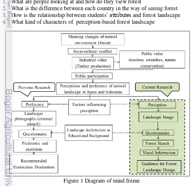
With the increase of global discussion regarding the natural environment, an understanding of different meanings of natural environment is important for local participatory environmental management and cross-national cooperation. The difference of various perceptions and interpretations of forests through understanding two countries’ perception and preference of environment might become a precondition of discussion for future cooperative environmental management (Figure 1):
1. What are people looking at and how do they view forest
2. What is the difference between each country in the way of seeing forest 3. How is the relationship between students’ attributes and forest landscape 4. What kind of characters of perception-based forest landscape
Objectives of Research
Because of the differences in perception of seeing landscapes, it is necessary to classify landscape image aspects of both students using LIST, to
know student’s attributes that may influence perception, and to formulate the
differences of forest landscape characters.
Benefit of Research
The result of this study might be useful as a guidance for forest landscape design in both countries-Japan and Indonesia. Good design guidance could protect and sustain one of the most precious natural resources of both countries from becoming exploited and exhausted.
Scope of Research
The scope limits of the research included the scope of research and research object. The scope of research was limited to the study of visual data (landscape image sketch of forest), verbal data (key words and text of forest), factors influencing perception, and the characters of perception-based forest landscape. The scope of research object was students’ memory of forest landscape.
2 LITERATURE REVIEW
Perception and Preference
Perception is an image, understanding, and interpretation of a person to an object, especially how people connect obtained information from the environment. The perception form is different from one to another because of the influence of intellectual background, emotional experience, relationship, and attitude. Meanwhile the depth of perception will be proportional to the increasing number of intellectual depth and emotional experience experienced by a person (Eckbo 1964). Furthermore, Porteous (1977) adds that the perception will determine
someone’s actions on the environment. One of the observed objects is landscape in which someone will perceive the landscape that has been observed (Nasar 1988). Someone's perception of landscape quality is determined by strong interaction between landscape variables and knowledge of a person towards the landscape. The result of the assessment is good or not good. The level of the assessment depends on the satisfaction of someone's feelings towards the landscape.
People’s attitude in evaluating landscape was driven by their perception
initiated by stimulus (Blake and Sekuler 2006). Referring to Ueda (2009), landscape perception was defined as landscape image, which is a medium
landscape and landscape representation. By externalizing landscape image directly as visual information, the variation of students’s perception could be understood that it might encourage the preference differences in the way of seeing the landscape. Preference is determined by many factors as part of the
decision-making process. Factors affecting people’s preference towards an object or
landscape visual quality are determined by object or quality of the landscape and the observed psychological state of society. According to Laurie (1990), the personal attributes affecting human perception and preference of the environment are age, social level, cultural background, past experiences, and one's routine activities. In their application of human perception and preference, making of landscape science can be found in many activities such as decision-making in visual landscape assessment.
Fukei Theory
The basic idea of this research derives from Lynch's ‘The Image of the City’ (Lynch 1960). The image of the environment claims that in cities, “every citizen has had long associations with some part of the city, and his image is blended in his memories and meanings”. There are important elements in the built structure of city for perception of the city. Lynch (1960) defines those three components of an environmental image: identity, structure, and meaning. Identity refers to one’s identity, not equality with something else. Structure is the spatial pattern and relationship of the object to the observer and to other surrounding objects. According to the observer, meaning is a complex practical and emotional relationship, which is not as easily influenced by physical manipulation as the other two components. Thus, observer with different cultures social, nature experience, background may vary the way of seeing the landscape significantly.
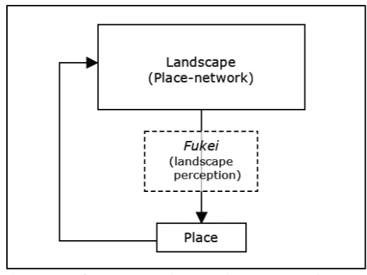
In contrast, Nakamura (1982) in Ueda (2012) suggests that landscape image concept that can be regarded as a section of Lynch's environmental image is perceived from a particular viewpoint that points self-orientation in the environment. He explains landscape of fukei in a Japanese sense as a phenomenon with five characteristics: views, knowledge, orientation, place-network and generation. View is a limited spatial landscape in the sight of a person standing on the ground. Knowledge is a representation of linguistic elements. Orientation is the position of a person-environment relationship in the environment which locates personal values of landscape. Place-network is a setting of experiences and an accumulation of the consequences. Generation is the agent of change in fukei
phenomenon. In this regard, the main focus of fukei is a way of seeing the landscape to recognize a place. Fukei phenomenon is a basic process in which the latent structure of place is broken down with the help of spatial view, linguistic
knowledge and subject’s self-orientation through time creating a new value (Nakamura 2001 in Ueda 2012). Referring to this definition, fukei can be positioned as a transformation from landscape to place (Figure 2), in which spatial
Figure 2 Fukei as a meaning-making process of a place
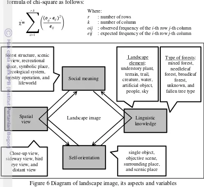
Landscape Image
Lynch's environmental image and Nakamura's idea of landscape image have common points. Emphasizing on it, they try to describe the idea of landscape image as a core concept of an empirical methodology. Landscape image consists of the spatial and semiotic aspects of the landscape. Ueda et al. (2012) stated that the combination of Nakamura's view and knowledge is in line with Lynch's identity in terms of the process to create the landscape. The two aspects of the landscape image are called spatial view and linguistic knowledge. The main role of landscape image is to relate the subject to the environment and to test people’s attitude and intention. The representative standpoint in the structure of the relationship between people and environment is called self-orientation. Furthermore, experience and communication in social group creating the relationship of place and network are in line with public image. We can see that both interaction of spatial view and linguistic knowledge and the integrating process of individual self-orientation and social meaning are proceeded through
observer’s experience and communication as a temporal change, namely, generation. The communication is mediated by a landscape through spatial view and linguistic knowledge. At the same time, landscape image is formulated within a certain cultural framework and it normalizes individual perception and social construction (Figure 3).
Figure 3 Diagram of landscape image
Landscape Image Sketching Technique (LIST)
Landscape Image Sketching Technique (LIST) consists of a combination of a brief sketch of various landscape, keywords reffering to landscape, and short verbal description of landscape done by respondents (Ueda 2009). This method could represent one’s view towards spatial environment and linguistic value orientation. Nakamura (1982) in Ueda (2012) explained the most distinctive character of LIST is the analysis of visual data of a scenic sketch. The drawing sketch is a kind of representation of one’s landscape image which can be interpreted with some main elements like mental mapping based on the classic idea of gestalt psychology. Ueda also emphasized that the three phases have four
Fukei conditions: 1) identification of landscape elements (through spatial view and linguistic knowledge), 2) structure of person-environment relationship (as self-orientation), and 3) the meaning (intersubjective values) of place according to
3 METHODS
Object and Time of Research
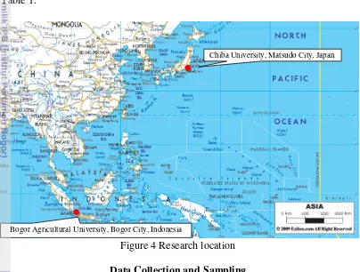
The object of the research was student’s memory of forest landscape. In
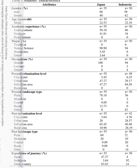
order to take the perception of forest landscape among different people, university students of Chiba University and Bogor Agricultural University were selected as respondents. Chiba University is located in Matsudo, Chiba Prefecture, next to Tokyo Metropolitan Area, while Bogor Agricultural University is located in Bogor, West Java Province (Figure 4). The survey was taken place during February until April 2013. The analysis and interpretation started from December 2013 until February 2014. The students’ attributes in each coutry are described in Table 1.
Figure 4 Research location
Data Collection and Sampling
Nowadays, the context of the multiple values of forests, especially for conducting LIST, involves not only merely experts, but also students (Ueda 2006; Pratiwi et al. 2013) and general society or local residents (Ross and Wall 1999; Ueda 2009). The sampling method applied in this research was non-random sampling technique (purposive sampling) in which the sample selection used the criteria below. The first criterion of respondents selected was independent respondents who were not influenced by the experience of visit to Japan or Indonesia. The second criterion of students was as the nature observer who had studied basic of Environmental Science and experienced within forest. Their educational history has a major influence on environmental attitudes (Takayama 2013).
Chiba University, Matsudo City, Japan
Table 1 Students’ characteristics
Attributes Japan Indonesia
Gender (%)
Present urbanization level
City center
Past urbanization level
City center
Experience of journey (%)
the sample size approximately 30 to 500 subjects, 2) the sample size at least 30 subjects for each parts. This research examined the significant difference between Japan and Indonesian students to perceive forest landscape, the relationship
among students’ attributes and forest landscape, and forest landscape characters in both countries. The determination of sample size in this research was 105 students (55 students from Chiba University and 50 students from Bogor Agricultural University). The students consisted of undergraduate and graduate students of Landscape Architecture and Environmental Science. In the terms of sample size, the number of students was sufficient, because the research sample or research object for each country was more than 30 respondents as expressed by Gay and Diehl (1992), Roscoe (1975), and Fraenkel & Wallen (1993) in Wiyadi (2009).
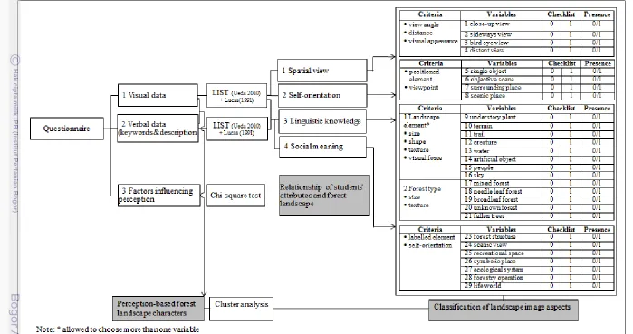
Data Analysis Procedure
The data was obtained through survey using questionnaire and tested to 105 university students (55 students from Chiba University and 50 students from Bogor Agricultural University) using Landscape Image Sketching Technique (LIST). The questionnaire was arranged using their native language for equal understanding of questionnaire as research instrument and filled out by students using pen to avoid systematic error. LIST is one of the effective methods to analyze the meaning of environment. Based on Lucas (1991) and Ueda (2010), research procedure for developing design concept consists of landscape image survey, landscape image analysis, and forest landscape interpretation (Figure 7). Landscape Image Survey
1. Key words and text of forest
The students were asked to imagine forest to recall and recollect the imagery from their memory. Then, the students gave some keywords relating to forest and explained the situation within forest based on the words they made with short verbal description of their forest image. This part was the first step in conducting LIST method described in Ueda (2006, 2009, 2010), Ueda et al.
(2012), and Mizuuchi et al. (2013). 2. Landscape image sketch of forest
The same students drew a brief sketch of their forest image (Figure 5). Generally, the meaning of the environment might be only interpreted through verbal description. Using landscape image sketch, it is expected as a method to fulfill the inconsistent verbal data.
3.Students’ attributes
Related to the LIST, some students’ attributes were necessary to be asked, namely, gender, age, past landscape type, present landscape type, past urbanization level, present urbanization level, and experience of journey. As Takayama (2013) suggested, these possible factors may lead to differences in environmental attitudes between research sites in Japan and Indonesia. It was expected that landscape types of home base with some physical changes of forest expressed the relationship with their perception.
Landscape Image Analysis
1. Analysis of visual and verbal data
Visual and verbal data were analyzed in three phases of LIST. The analysis was implemented onto four fukei conditions (landscape image aspects), namely, identification of landscape elements (through spatial view and linguistic knowledge), structure of person-environment relationship (through self-orientation), and the meaning of place (through social meaning). This method provides new insights into the understanding of public image through landscape perception (Ueda 2010).
Linguistic knowledge. Landscape elements were labelled verbally and identified visually: understory plant, terrain, trail, creature, water, artificial object, people, and sky. At the first step, landscape element was identified relating to the words and shapes selectively. Furthermore, according to landscape element, the types of forest in Japan and Indonesia could be classified into mixed forest, needle leaf forest, broadleaf forest, unknown forest, and fallen tree type.
Spatial view. View angle and distance were classified visually according to the visual appearance of each landscape element. The represented visual appearance of each landscape element could be understood in terms of view angle and distance indicating which part of landscape was captured from certain viewpoint. For landscape image sketch of forest, the size of tree symbols and texture were classified into four groups: close-up, sideway, bird eye, and distant view.
Self-orientation. The relationship between various elements and viewpoint showed visually the way of perceiving self-orientation in represented landscape image sketch belonging to the students. This relationship reinforced the representation of a person–environment relationship. The results were classified into four groups: single object, objective scene, surrounding place, and scenic place.
Social meaning. The meaning of the forest was interpreted visually and verbally in relation to landscape element and self-orientation. This personal meaning showed the meaning of landscape as a place with various interests. The pattern of landscape image of certain social group was categorized into eight groups: forest structure, scenic view, recreational space, symbolic place, ecological system, forestry operation, and lifeworld.
After having collected, each landscape image sketch was classified into landscape image aspects using checklist method. The presence of the variables in
the landscape image sketches was defined as ‘1’, while ‘0’ indicated the absence
Japan and Indonesia in perceiving forest landscape. The only significant variable at p<0.05 was discussed to characterize the landscape images in Japan and Indonesia. Statistical calculation which was applied to test the significant difference between students of Japan and Indonesia towards forest landscape used formula of chi-square as follows:
Figure 6 Diagram of landscape image, its aspects and variables
2. Analysis of factors influencing perception
The purpose of this analysis was to examine the relationship among students’ attributes and forest landscape. The questionnaire consisted of 7 variables, namely, gender, age, past landscape type present, landscape type, past urbanization level, present urbanization level, and experience of journey. Chi-square test was applied to examine their relationship.
3. Cluster analysis of perception
Having been classified into landscape image aspects, then the data consisting of 28 variables of landscape image aspects was analysed using cluster analysis (Table 2). Cluster analysis using Wards method and Jaccard similarity index was applied to characterize forest landscape. Jaccard’s coefficient is measurement of asymmetric information on binary variables based on the presence and absence of data and is calculated as the mean of the clusters (He and Barclay 2000). The negative value and non-existence are not counted in this case,
Landscape image Social meaning
Spatial
view knowledge Linguistic
Self-orientation
oij : observed frequency of the i-th row j-th column eij : expected frequency of the i-th row j-th column χ²= (oij- eij )
2
eij r.k
so Jaccard similarity index will not represent double absence. The cluster analysis step was conducted as follows (Supranto 2010): 1) defining problem, 2) choosing measure of distance, 3) selecting clustering procedure, 4) considering the number of cluster, and 5) interpreting profile of cluster.
Table 2 Variables of landscape image Linguistic Knowledge
Spatial View Self Orientation Social Meaning Landscape
Element
Forest Type
Understory plant Mixed forest type
Close-up view Single object Forest structure Terrain Needle leaf
forest
Sideway view Objective scene Scenic view Trail Broadleaf forest Bird eye view Surrounding
place
Recreational space
Creature Unknown forest Distant view Scenic place Symbolic place
Water Fallen trees Ecological
system
Artificial object Forestry
operation
People Lifeworld
Sky
Forest Landscape Interpretation
There were four types of basic elements or building blocks within forest: volume (three-dimensional), plane (two-dimensional), line (one-dimensional), and point which has significant position, but almost no dimension. These elements can vary in a number of ways (variable) including size, shape, number, position, direction, interval, texture, color, visual force, time, and lighting. Because the variety of possible combinations and its overall effect are complex, the ways of organizing elements and variable (organizational factors) are needed. Organizational factors can be used to group elements, for example nearness, while others such as rhtym, balance, scale, and tension are used to give overall structure to a design.
4 RESULTS AND DISCUSSION
Classification of Landscape Image Aspects
Linguistic knowledge
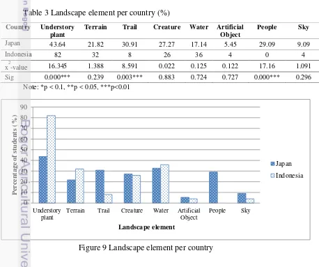
Figure 8 Classification of landscape element. From left to right and top to bottom: understory plant, terrain, trail, creature, water, artificial object, people, sky
As a result of statistical analysis, the probability value of understory plant (0.000), trail (0.003), and people (0.000) was less than α=0.05. Therefore, it could be concluded that there is significant difference between students of Japan and Indonesia in perceiving forest landscape, especially in understory plant, trail, and people variables (Figure 9). It reflected their culturally different ways of representing understory plant. In Indonesian sketches, there were so many types of understory plant such as flowers, fallen leaves, spices plants, medicine plants, and underbush, while in Japanese sketches, there were only underbush and fallen leaves. In Japanese sketches, the trail and people’s position were depicted inside forest.
Table 3 Landscape element per country (%)
Note: *p < 0.1, **p < 0.05, ***p<0.01
Country Understory plant
Terrain Trail Creature Water Artificial Object
Terrain Trail Creature Water Artificial Object
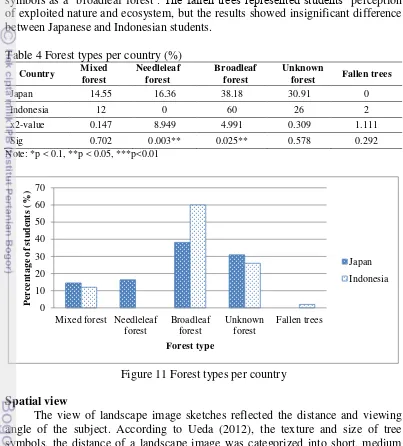
Forest type in image sketches was labelled and calculated (Table 4). Forest type was classified into mixed forest, needle leaf forest, broadleaf forest, unknown forest, and fallen trees type according to the shape of tree symbols (Figure 10). A mixed forest type consisted of various tree symbols representing conifers and broad leaf trees. Some students drew multiple tree symbols with various height to represent a mixed forest. A needleleaf forest type consisted of single type of tree symbol in christmas tree or conifer shape, while broadleaf forest type was represented by rounded tree shape. In contrast, some image sketches were shown as only silhouette of mountains, the trunks or branch of trees, and the forest type in distant view. It was difficult to judge them, therefore, they were classified into unknown forest type. Furthermore, some image sketches included cuts off and stumps on the forest floor were called as fallen tree type.
Through this research, students were specifically asked to draw their forest image which the represented tree types often reflected the local dominant landscape. For example, in Indonesia, some image sketches of high trees with the biodiversity reflected the tropical broadleaf forest type, while Japanese coniferous plantations reflected the actual landscape of man-made needle leaf forest type (Figure 11). The image sketches do not always reflect the actual landscape and local native vegetation, but imply the subject's cultural perspective of the forest (Ueda 2012).
As a result of statistical analysis, the probability value of needle leaf (0.003) and broadleaf forest type (0.025) was less than α=0.05. Therefore, it could be concluded that there is significant difference between students of Japan and Indonesia in perceiving forest landscape, especially in needle leaf and broadleaf forest type variables. Nine Japanese students (16.36%) drew needleleaf forest type, while 30 Indonesian students (60%) tended to place a single type of tree symbols as a ‘broadleaf forest’. The fallen trees represented students’ perception of exploited nature and ecosystem, but the results showed insignificant difference between Japanese and Indonesian students.
Table 4 Forest types per country (%)
Country Mixed
forest Fallen trees
Japan 14.55 16.36 38.18 30.91 0
Indonesia 12 0 60 26 2
x2-value 0.147 8.949 4.991 0.309 1.111
Sig 0.702 0.003** 0.025** 0.578 0.292
Note: *p < 0.1, **p < 0.05, ***p<0.01
Figure 11 Forest types per country
Spatial view
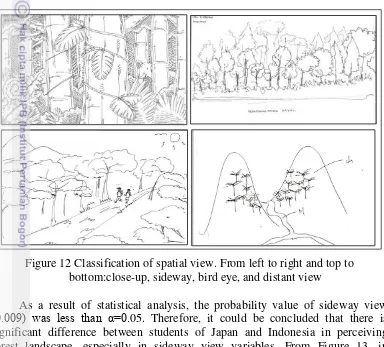
The view of landscape image sketches reflected the distance and viewing angle of the subject. According to Ueda (2012), the texture and size of tree symbols, the distance of a landscape image was categorized into short, medium and long distance. Short distance consists of close-up view which the texture and color are clearly recognized. Medium distance consists of sideway and bird's-eye view which visualizes the landscape form generally. Long distance consists of distant view which is dominated by horizon. Consequently, the view of landscape image was classified into close-up, sideway, bird eye, and distant view (Figure 12).
The close-up view is represented by the trunks or branch of the trees showing in the near distance. Through this distance, the texture of leaves, bushes, small animals can also be seen, however, outside scenery can not be seen sclearly.
The sideway view is represented by whole tree shapes which usually imply the forest structure, the section of forest, forest fringe, or vegetation composition of forest. Bird eye view is represented by the trees positioned above and wide expanse of the forest including landscape element and people on the ground that can be seen from the top. The distant view is represented by shape of mountains without any tree symbols, hence, we can not recognize the shape, size, color, even type of trees. The view of landscape image sketches was labelled and calculated (Table 5).
Figure 12 Classification of spatial view. From left to right and top to bottom:close-up, sideway, bird eye, and distant view
As a result of statistical analysis, the probability value of sideway view
(0.009) was less than α=0.05. Therefore, it could be concluded that there is significant difference between students of Japan and Indonesia in perceiving forest landscape, especially in sideway view variables. From Figure 13, in Indonesia, sideway view was the major variable followed by bird eye, close-up, and distant view. Indonesian students viewed forest as a section, forest fringe, or vegetation composition. In contrast, Japanese students viewed forest with human attributes in close-up view which slightly characterized Japanese image sketches.
Table 5 Spatial view per country (%)
Country Closeup view Sideway view Bird eye view Distant view
Japan 27.27 30.91 27.27 14.55
Indonesia 12 56 24 8
x2-value 3.818 6.733 0.147 1.109
Sig 0.051* 0.009*** 0.702 0.292
Figure 13 Spatial view per country
Self-orientation
The orientation of people-environment relationship was analyzed from the combination of the landscape elements and the viewpoint in the sketches.
Subject’s activities and their accessibility to the forest could be recognized by
spatial continuity from the viewpoint or setting of the standpoint, such as trail, vehicle, and house. Whereas forest description as objects in a scene implied the separation between forest and subject's viewpoint. The landscape element, subjects, even creature, are sometimes drawn in the scene. Moreover, Ueda (2012) explained that the fundamental person–environment relationship does not necessarily relate to the verbal descriptions of forest, because the linguistic description explains the forest objectively, but the visual landscape image sketches reveal how the people relate the other elements in the forest image. Then, the objects in the forest landscape and the descriptions of activities were classified into four groups, namely, single object, objective scene, surrounding place, and scenic place (Figure 14).
Single object is an extracted figure from the landscape. The single element or cluster of the elements is being focused on and objectified. Objective scene is based on the placement of depicted various elements that constructing a place as scenery. It represents a relationship among landscape elements without spatial continuity from the viewpoint. In contrast, surrounding place is an expression of the students’ own standpoint in the forest. Trail, vehicle, and house are drawn in the centre of the frame in which they describe the people's activities in natural surroundings. Scenic place is a prospect from a short, medium or long distance viewpoint outside forest, typically an expression of natural surroundings from the subject's standpoint that can be seen as a combination of objective scene and viewpoint on the sketch (Ueda 2009).
0
Closeup view Sideways view Bird's eye view Distant view
Figure 14 Classification of self-orientation. From left to right and top to bottom: single object, objective scene, surrounding place, scenic place
As a result of statistical analysis, the probability value of surrounding place (0.002)was less than α=0.05 (Table 6). Therefore, it could be concluded that there is significant difference between students of Japan and Indonesia in perceiving forest landscape, especially in surrounding place variable. Surrounding place characterizing Japanese image sketches reflected the number of people for recreational or religious activities. Meanwhile scenic place slightly characterized Indonesian image sketches including objective scene with certain viewpoint (Figure 15).
Table 6 Self-orientation per country (%)
Country Single object Objective scene Surrounding
place Scenic place
Japan 40 16.36 32.73 10.91
Indonesia 48 20 8 24
x 2
-value 0.681 0.234 9.669 3.16
Sig 0.409 0.629 0.002*** 0.075*
Figure 15 Self-orientation per country
Social meaning
The three aspects of landscape image above were reconstructed to outline the social meaning of a forest using the verbal data as complementary information. The description and keywords of forest referred to multiple topics and they were represented visually in the same framework of a sketch. The multiple motives were labelled as verbal data. Consequently, the results showed similar feature with linguistic knowledge, but these results provided more information than linguistic knowledge those found. Based on Ueda (2009), the social meaning was classified into seven groups, namely, forest structure, scenic view, recreational space, symbolic place, ecological system, forestry operation, and lifeworld (Figure 16).
Forest structure is a static explanation of vegetation structure which is usually objectified as forest types or mountain with the fewest landscape elements in the sideway view. This variable is described without forest usage, but it is only described with tree or mountain as a single landscape element. Scenic view is an idyll prospect of objective scene or scenic place category. It consists of various scenery in viewing angle: close-up and sideway view as foreground; and distant view as background. This variable is also described with emotional and aesthetic verbal description of the scenery. Recreational space is depicted with trail for people activities in the forest, and it mainly described as a surrounding place. Symbolic place is composed of single object such as a particular tree or part of a symbolic scene. It is depicted as a close-up view and described with strong impressions. This variable is rarely found in the sketches, except in Japanese sketches. There is a forest imagination consisting of unusual element. Ecological system is represented by description of dynamic system with fauna and flora (creature) or as an objective scene. Forestry operation represents distinctive methods of the forestry industry. In forestry operation variable, there was only Japanese students depicteding coniferous forests of Japanese cedar which was one of the three most beautiful man-made forests in Japan. They usually emphasized the regular tree stand and traditional method of forestry operation, notably the
Single object Objective scene Surrounding place Scenic place
surrounding woods and connected with settlements (artificial objects) which shows the daily life activities with the multiple variations of landscape elements in surrounding place.
Figure 16 Classification of social meaning. From left to right and top to bottom: forest structure, scenic view, recreational space, symbolic place, ecological system, forestry operation, lifeworld
representation of environmental attitudes was not included when they perceived the forest. Indonesian students preferred diverse sceneries to monotonous scenery in a frame. However, in Japanese sketches, the scenery composed with the artificial elements of trail, temples or shrines became significant difference in characterizing forest as recreational space (Figure 17). This variable represented
forest as the people’s accessible natural environment.
Table 7 Social meaning per country (%) Country Forest
Figure 17 Social meaning per country
Prominent component of forest landscape using LIST (Ueda 2010) was classified and interpreted into landscape appraisal as basis for developing design concept (Lucas 1991). A total of ten prominent components was detected in Japan and Indonesia (Table 8). Prominent component in Japan was landscape element, while in Indonesia it was social meaning. In further details for developing forest landscape design (Lucas 1991), Japan had forest usage characterized by trail, people, surrounding place, and recreational space, while Indonesia had natural components and views characterized by understory plant, broadleaf forest, and sideway view to perceive forest landscape.
settlement. Japanese people used forest as religious activities and recreational space. Meanwhile Indonesian people did their religious activities in mosque, church, shrine, or temple located in the center of settlement. Based on Pratiwi (2013), Ukiyo-e, genre of woodblock prints or woodcuts and paintings in Japan, especially one of Katsushika Hokusai’s pictures mostly depicted landscape and nature, like views of Mount Fuji which is combined by sea, lake, forest, agriculture farm, cherry blossom trees, and cultural building such as temple in close-up and distant view. This historical painting formed and influenced Japanese’s recognition and perception of landscape. Therefore, they distinguished the landscape based on the viewpoint.
In Indonesia, social meaning that was expressed by forest structure and scenic view indicated important factors in influencing forest design, namely, forest stands and aesthetic factors. Syaukani (2005) reinforced that the higher vegetation diversity index, the higher diversity in forest structure among the other areas. It showed that forest structure implied the variation in age, species, and management regimes (Lucas 1991). Moreover, nature landscape painting in Indonesia, especially in Abdullah Soerjo Soebroto’s painting consists of various complementary attributes such as dramatic cloud, yellowish ricefield, layered mountainuous as middle ground and huge mountain as background (Ueda 2012; Hilary and Hujatnika 2013). This diversity of sceneries and the unity of local attributes are identified as the aesthetic factors in the forest (Lucas 1991). In this regard, prominent components based on LIST were explained further and they were in line with landscape appraisal.
Table 8 Prominent component of landscape image aspects
Landscape image (Ueda 2009) Linguistic knowledge
Note: Significant components in Japan
Factors Influencing Perception
Students’ attributes consisted of gender, age, past and present landscape type, past and present urbanization level, and experience of journey. Figure 18 shows that the number of male students (31.43% in Japan, 27.62% in Indonesia) were higher than female students (20.95% in Japan, 20% in Indonesia). At age attribute, Indonesian students have more various ages than Japanese students. At landscape type attribute, plain landscape was selected as the most liveable home stay in both countries. Moreover, at urbanization level attribute, rural area became scarcely populated region. Japanese students have the higher experience of journey than Indonesian students. About 48 Japanese students had ever travelled to foreign countries (45.71%).
Figure 18 Students’ attributes per country
Students’ attributes and linguistic knowledge
Among the Japanese students, two attributes had significant relationship with variables of linguistic knowledge, namely, past landscape type and past urbanization level (Table 9). As a result of statistical analysis, probability value of past landscape type and understory plant (0.026), and past urbanization level and water (0.030) was less than α=0.05. Therefore, it could be concluded that there is
landscape type (5.45%) perceived understory plant as landscape element. Mountain area and its surrounding have various types of understory plants because they were formed by fertile soil from the volcano erruption. Whereas two Japanese students living in city center (3.64%), 2 students in urban area (3.64%), 10 students in suburban area (18.18%), and 4 students in past rural area (7.27%) perceived water as landscape element (Figure 20). The water element such as lake, river, and stream could be found almost in suburban area and rural area which consist of more natural landscape than city center and urban area.
Table 9 Japanese students’ attribute and linguistic knowledge
Note: *p < 0.1, **p < 0.05, ***p<0.01, Mf: mixed forest, Nf: needle leaf forest, Bf: broadleaf forest, Uf: unknown forest, Up: understory plant, Te: terrain, Tr: trail, Cr: creature, Wa: water, Ao: artificial object, Pe: people, Sk: sky
Figure 20 The percentage of students related to past urbanization level in perceiving water
Among Indonesian students, six attributes had significant relationship with variables of linguistic knowledge, namely, past landscape type, present landscape type, past urbanization level, present urbanization level, gender, age (Table 10). As a result of statistical analysis, probability value of past landscape type and understory plant (0.021), present landscape type and mixed forest (0,006), present landscape type and creature (0.012), past urbanization level and mixed forest (0.027), present urbanization level and creature (0.020), and present landscape urbanization and sky (0.000), gender and mixed forest (0.029), gender and terrain (0.022), age and fallen trees (0.000) was less than α=0.05. Therefore, it could be
concluded that there is relationship between students’ attributes and forest
landscape. Figure 21 until 28 show the percentage of students’ attribute in perceiving forest. A male students (2%) and 5 Indonesian female students (10%) perceived mixed forest as forest type. Each an Indonesian student (2%) living in plain and mountain, and 4 students in present basin landscape type (8%) perceived mixed forest as forest type. A student (2%) living in urban area, 2 students (4%) in suburban area, and 3 students in past rural area (6%) perceived mixed forest as forest type. An Indonesian student of 37-45 years old (2%) sketched fallen trees as forest type. Twenty five Indonesian students (50%) living in plain, 6 students in mountain (12%), and 5 students in coastal and past basin landscape type (10%) perceived understory plants as forest elements. The understory plants element was depicted by students living in all landscape types. Thirteen Indonesian male students (26%) and 3 female students perceived terrain as forest elements (6%). Male students have more experiences in outdoor recreation such as hiking or mountain biking than female students, thus they depicted terrain as one of landscape elements in their forest sketch. Three Indonesian students (6%) living in plain and 10 students in present basin landscape type (20%) perceived creature as landscape element. Thirteen Indonesian students living in present suburban area (26%) perceived creature as landscape element. Whereas a student living in present suburban area perceived sky as forest element (2%).
0
City center Urban area Suburban area Rural area
Table 10 Indonesian students’ attributes and linguistic knowledge
Note: *p < 0.1, **p < 0.05, ***p<0.01, Mf: mixed forest, Bf: broadleaf forest, Un: unknown forest, Ft: fallen trees, Up: understory plant, Te: terrain, Tr: trail, Cr: Creature, Wa: water, Ao: artificial object, Sk: sky
Figure 21 The percentage of students related to gender in perceiving mixed forest
Figure 23 The percentage of students related to past urbanization level in perceiving mixed forest
Figure 24 The percentage of students related to age in perceiving fallen trees
Figure 25 The percentage of students related to past landscape type in perceiving understory plant
Urban area Suburban area Rural area
Figure 26 The percentage of students related to gender in perceiving terrain
Figure 27 The percentage of students related to present landscape type in perceiving creature
Figure 28 The percentage of students related to present urbanization level in perceiving creature and sky
Students’ attributes and spatial view
Statistically significant relationship among Indonesian students was not detected (Table 11), while among the Japanese students, an attribute had significant relationship with variable of spatial view, namely, past landscape type and sideway view (Table 12). As a result of statistical analysis, probability value of past landscape type and sideway view (0.038) was less than α=0.05. Therefore, it could be concluded that there is relationship between students’ attributes and forest landscape. Figure 29 shows the percentage of students’ attributes in perceiving spatial view. Eleven Japanese students living in plain (20%) and 3 students in coastal and past basin landscape type (5.45%) perceived sideway view as their spatial view of forest. People living in past plain landscape type sketched their forest from sideway view. They could view the forest clearly in particular distance describing the section of forest and composition of forest structure.
Table 11 Indonesian students’ attributes and spatial view Variable
Attribute
Close-up Sideway view Bird eye view Distant view
Gender 0.180 0.474 0.520 0.473
Age 0.776 0.491 0.199 0.820
Past landscape type 0.357 0.214 0.186 0.678
Present landscape type 0.868 0.474 0.632 0.717
Past urbanization level 0.446 0.157 0.481 0.450
Present urban level 0.740 0.623 0.226 0.213
Experience of journey 0.166 0.563 0.609 0.159
Table 12 Japanese students’ attributes and spatial view Variable
Attribute
Close-up Sideway view Bird eye view Distant view
Gender 0.912 0.873 0.619 0.780
Age 0.099* 0.500 0.537 0.677
Past landscape type 0.086* 0.038** 0.954 0.439
Present landscape type 0.650 0.308 0.840 0.505
Past urbanization level 0.059* 0.220 0.820 0.224
Present urban level 0.275 0.328 0.525 0.590
Experience of journey 0.808 0.972 0.275 0.264
Figure 29 The percentage of students related to past landscape type in perceiving sideway view
Students’ attributes and self-orientation
Among the Japanese students, three attributes had significant relationship with variables of self-orientation, namely, past urbanization level and scenic place, experience of journey and single object, and age and scenic place (Table 13). As a result of statistical analysis, probability value of past urbanization level and scenic place (0.002) experience of journey and single object (0.029), age and scenic place (0.004) was less than α=0.05. Therefore, it could be concluded that there is
relationship between students’ attributes and forest landscape. Figure 30 shows that 12 students (21.82%) travelling abroad and 10 Japanese students (18.18%) travelling around Japan perceived single object as self-orientation in the forest. Whereas five students of 27-35 years old (9.09%), 1 student of 19-26 years old (1.82%), 1 students living in city center (1.82%), 2 students in suburban area (3.64%), and 3 Japanese students in past rural area (5.45%) perceived scenic place as self-orientation in the forest (Figure 31 and 32). The middle age students and students living in rural area had more scenic feeling than students living in suburban area, even city center.
Table 13 Japanese students’ attributes and self-orientation
Note: *p < 0.1, **p < 0.05, ***p<0.01 Variable
Attribute
Single object Objective scene Surrounding place Scenic place
Gender 0.580 0.425 0.637 0.269
Age 0.410 0655 0.481 0.004***
Past landscape type 0.631 0.495 0.782 0.555
Present landscape type 0.252 0.060* 0.889 0.843
Past urbanization level 0.263 0.416 0.411 0.002***
Figure 30 The percentage of students related to experience of journey in perceiving single object
Figure 31 The percentage of students related to age in perceiving scenic place
Figure 32 The percentage of students related to past urbanization level in perceiving scenic place
City center Suburban area Rural area
Among Indonesian students, an attribute had significant relationship with variable of self-orientation, namely, experience of journey and objective scene (Table 14). As a result of statistical analysis, probability value of experience of journey and objective scene (0.03) was less than α=0.05. Therefore, it could be
concluded that there is relationship between students’ attributes and forest landscape. Figure 33 shows that 5 Indonesian students (10%) travelling around Indonesia and abroad perceived objective scene as self-orientation in the forest. Experience of journey encourages people to find, observe, and perceive forest landscape. Having experience by visiting various place of their country or other countries with different landscape characteristics, students have different ways in seeing landscape.
Table 14 Indonesian students’ attributes and self-orientation
Note: *p < 0.1, **p < 0.05, ***p<0.01
Figure 33 The percentage of students related to experience of journey in perceiving objective scene
Students’ attributes and social meaning
Statistically significant relationship among Indonesian students was not detected (Table 15), while among the Japanese students, four students’ attributes had significant relationship with variables of social meaning, namely, present landscape type and forest structure, past urbanization level and scenic view, past urbanization level and symbolic place, present urbanization level and scenic view, and age and scenic view (Table 16). As a result of statistical analysis, probability value of present landscape type and forest structure (0.035), past urbanization
Variable
Attribute
Single object Objective scene Surrounding place Scenic place
Gender 0.598 0.115 0.735 0.520
Age 0.535 0.083* 0.820 0.801
Past landscape type 0.267 0.875 0.056* 0.470
Present landscape type 0.573 0.862 0.375 0.632
Past urbanization level 0.304 0.774 0.384 0.481
level and scenic view (0.011), present urbanization level and scenic view (0.029), past urbanization level and symbolic place (0.04), and age and scenic view (0.032), was less than α=0.05. Therefore, it could be concluded that there is
relationship between students’ attributes and forest landscape. Figure 34 until 38
show students’ attributes in perceiving forest landscape. Nine students living in plain (16.36%) and 3 students (5.45%) in present coastal landscape type perceived forest structure. Two students living in city center (3.64%), 1 student (1.82%) in urban area, 5 students in sub urban area (9.09%), and 2 students in past rural area (3.64%) perceived scenic view. Two students living in city center and urban area (3.64%), and 6 students in present suburban area (10.91%) still perceived scenic view. Nine students of 19-27 years old (16.36%), 1 student of 28-36 years old (1.82%) %) perceived scenic view. Whereas a student living in past rural area (1.82%) perceived symbolic place as social meaning of forest. Kodama sketched by Japanese students describes a spirit living in a tree. In animated film, kodama appears like white humanoids with large, rattling heads, and has mask-like features, moreover, it is similar to bobbleheads like what Japanese students sketched in their image sketch.
Table 15 Indonesian students’ attributes and social meaning Variable
Figure 34 The percentage of students related to present landscape type in perceiving forest structure
Figure 35 The percentage of students related to past urbanization level in perceiving scenic view
Figure 36 The percentage of students related to present urbanization level in perceiving scenic view
City center Urban area Suburban area
City center Urban area Suburban area