Enabling Mobile Location Based Services for Emergency Cases
Noraziahtulhidayu Kamarudin
Faculty of Information and Communication Technology Universiti Teknikal Malaysia Melaka
Melaka, Malaysia
Email:hidayu.kamarudin@gmail.com
Sazilah Salam
Faculty of Information and Communication Technology Universiti Teknikal Malaysia Melaka
Melaka, Malaysia Email:sazilah@utem.edu.my
Abstract— Late attention by officers in charge to high volumes of crimes and emergency cases can lead to an increase of unsolved cases nationwide. In this paper, we propose the use of Pull & Push Location Based Service model in experiments of the implementation of Location Based Service environment to lessen the problems faced by Police and Fire Fighters in retrieving accurate information while patrolling high risk area. The time taken and the accuracy of information are problems normally faced by Police and Fire Fighters in Emergency Case department. It is crucial for them to get the right information at the right time to their walkie talkie or mobile phones. We first proposed the usage of RSS as the web services to provide feeds for the smart phone application. Updates on crimes or emergency cases within the users’ locations are sent upon users’ retrieval or push based on the users’ locations. The application is developed by using Eclipse IDE platform and tested using HTC Magic with Android OS. The application flow starts by retrieving the location position and information on emergency cases will then be displayed according to date listed. The conceptual design and architecture are designed for Pull and Push Location Based Services.
Keywords-Location Based Service, emergency finder, pull LBS model, mobile LBS
I. INTRODUCTION
A number of studies been done on location-based services (LBS) due to its wide range of potential applications. LBS can be used to provide useful information such as tourism guide and roadside assistance to users according to the current locations of them. It is consisted of mobile devices, communication networks, service provider and data provider.[1]
The enormous trend of crimes happening in Malaysia shows the need for polices and fireman officers to get reports of emergency cases as fast as it could to enable to act effectively. In Malaysia, the emergency call number in Malaysia or the 999 hotline number is currently served by Telekom Malaysia, the biggest telecommunication provider here. The findings of a review found that international practice indicates that many jurisdictions use similar KPIs (Key Performance Indicator) of an 8-minute (or 7 minutes and 59 seconds) response time for first responders to attend
to a life-threatening incident [5]. Actual response times may vary due to local road characteristics, traffic lights, congestion, road networks, weather conditions, and visibility [9].
The hotline number is entertained by several operators that pick up emergency calls and record reports from the callers. Once all the details required are recorded, they channel the report to the correct agencies based on the problem faced by the caller. The caller’s identity and details like location and emergency details will be verified and if the call is a prank call, the operator will stop from the channeling process to the agencies.
This is a normal work flow at the emergency call centre every day. Time is the critical factor for the rescue of occupants and the application of extinguishing agents to minimize loss [10]. Crimes are solved based on the information channeled to the agencies and how fast the information can be delivered to the agencies targeted. A police officer which is on patrol should be alert to the information provided by the call centre and has to move right on getting the target.
II. PROBLEMSTATEMENT
At peak time, the emergency call constrained by the number of staff that wa the calls. It was due to the manual system be the agencies taking the emergency action much time wasting while on the op emergency cases involve life, one of the req by EMSS (Emergency Medical System Ser 95 percent of all ambulance response time twenty minutes in rural areas and within urban areas [8].
Callers that are urgently in much nee have to wait on the line if the line is bu reports cannot be channeled to the right many rescue cases cannot be served in tim get escaped and as a consequence more cri be solved or need longer time to get solved.
As the calls is recorded manually a system, sometimes the information being c the recipients is not clear and th misunderstandings among the recipients a centre and also the call centre.
Figure 1.1: Flow call for the emergency ca handled by TM in Malaysia [2 Figure 1.0: Call flow for the em
call management in Malaysi
at the call centre communicated to the existing flow of calls which Malaysia. Any calls for police ca centre agent will be diverted to the and this information will then be tra duty.
In this research, we are t workflow by reducing the pr improving the way alert is delivered
III. PURPOSEOFT
i. To investigate design con location based services fo cases.
ii. To design and develop a service to optimize the emergency cases.
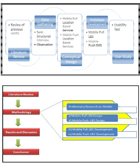
IV. METHODO
The methodology used for condu shown in Figur
Figure 1.2 Research m
We start with literature review by other researchers. Then, we con session using semi structured interv mergency
a [2].
10), Figure 1.1 showing is handled by Telekom ses received by the call police call centre agents ansmitted to the police on
trying to optimize the rocesses involved and d to the target recipients.
THESTUDY
siderations in providing r crime and emergency
a mobile location based workflow for handling
OLOGY
ucting this research is e 1.2.
methodology.
police call centre in Melaka. After compiling the data collected, we developed the conceptual design of the mobile pull & push location based services. Once we have developed the prototypes, then we conducted a user study to get feedbacks from users.
V. HOW LOCATION BASED SERVICE WORKS
Two broad categories of LBS can be defined as triggered and user-requested. In order to get the location of the device, the Location-Based Service should use the real time positioning method.
The spatial location is widely using the coordinate system or being understood as latitude-longitude-altitude. Latitude is a measurement of the angle at the Earth’s centre, north or south of the equator while for Longitude is a measurement of the angle at the Earth’s centre, east or west of the prime meridian which runs pole to pole through Greenwich[3]. The different LBS can be classified under multiple categories of person or device-oriented, push vs. pull, direct vs. indirect profile, among others [7].
A. Pull Location Based Service
The pull Location Based Architecture need or desire
triggers for the request of Location Based Advertising and considered as favorable attitudes toward the marketer.
B. Push Location Based Service
Push location based service is understood if the user in certain location is pushed the information related to their location currently. As example, if the users is around a cinema, he or she been pushed the information of a hot movie that showing in the cinema and they are attracted but to find that the tickets for the movies have been sent out in this cinema. So the user needs to request for query the result.
Push technology is playing a more and more important role in the mobile scenario as it allows new appealing services which foresee useful information to mobile users such like weather forecasts, traffic news, and sports news. It allows to establish a connection to a user terminal without a direct action and to deliver content as soon as possible.[1]
VI. LOCATION BASED SERVICE ARCHITECTURE
There are three ways for the user to get the positioning methods on their application as reported by which has been explained by [4].
A. The CellID System:
The CellID system positions the user equipment (UE) within the coverage of the serving cell. This information is of very limited value for a large cell, but viable information may be provided for a picocell with a range of about 100m.
B. Observed Time Difference of Arrival(OTDOA)
The OTDOA system uses triangulation from at least three base-stations to determine geographic position. The distance from each station is again calculated from Round Trip Time via the User Equipment.
C. Global Positioning System
The American military global positioning system uses satellite signals to determine a user’s location. It is the most accurate technology available, typically providing resolutions of less than 10 m.
VII. PROPOSED LOCATION BASED SERVICE ARCHITECTURE
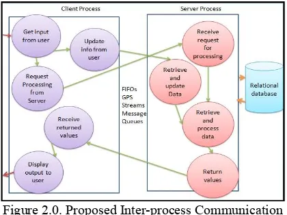
Figure 2.0. Proposed Inter-process Communication for Pull Location Based Service
The Inter-process Communication (IPC) in Figure 2.0 shows the flow of the design for current application developed. It involves in getting input from user and updating it. It also process the request from server and follows with received request for processing and retrieving information and ensure that the information displayed is matched with the current postcode that user currently in.
Figure 2.2:The work process of Telekom Call Centre[2]
Figure 2.1. Proposed N-Tier Architecture for Web Services, XML, HTTP server, PHP, feeder and
Database for Pull Location Based Service
process is performing separate functions. The data is passes between processes using the IPC functions.
Therefore, if the use of location based service is utilized, the call centre operator for 999 which is handled by Telekom Malaysia can automatically inserts the details of the emergencies from the client server computer and automatically stored into database. The information later is retrieved by using RSS feed and pull location based service technology by the targeted users like police and fire fighters.
The N-Tier architecture for the above Figure 2.0 shows
important element that is involved which is Internet and may access HTTP server contain PHP and Feeder. For the feeder that is provided by Web service is a standardized way of integrating web based applications using XML, SOAP (Simple Object Access Protocol) and WSDL (Web Service Definition Language). Web services not provide user with a GUI but instead sharing logic data through programmatic interface across a network. Different application may use other sources to communicate as it is not tied to any operating system or programming language. The connection for Web service is interlinking with SAXParser through feed atom and database.
On the Figure 2.2, the viewer may see the current flow chart of call handling that able to explained on the Emergency call flow. The researcher had already stated too that in the emergency call flow; it happen to have no automatic routing system, high in drop call, long queue, abandon call and no access during call congestion. And this will lead to have the very low public confidence as stated by [2].
VIII. RESULTSANDDISCUSSION
Figure 3.0 The Mobile Conceptual Design for Mobile Pull LBS in Police Emergency Case Management
Figure 3.5: Proposed call flow for Fire Fighters by using Pull Location Based Service Information
Retrieval.
Figure 3.2: The current workflow for emergency call handling by Fire Fighters
Figure 3.1 The Mobile Conceptual Design for Mobile Pull LBS in Fire Fighters Emergency Case Management
Figure 3.2 and 3.3 show the current workflow for an emergency call handled by the Fire Fighters and Police call centre. The estimated time taken is based on best time basis which is approximately within 5-8 minutes.
Figure 3.3: The current workflow for emergency call handling by Police
If the use of RSS is implemented for Pull Location Based Service in both of the agencies, the results of the emergency cases information can retrieved in 3 to 4 minutes as referred in Figure 3.4 and Figure 3.5. Therefore the information will be more organized as it is stored into the system database and also this will remove one step that lessen the processed involved and time taken. The work of a patrol officer for police and the fire fighters will bitterly be more organized.
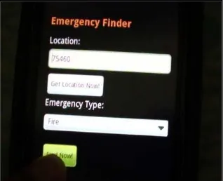
Figure 3.6: The Emergency Type option that be selected by the user in order to get the information of emergency
cases within their area.
Figure 3.4:Proposed call flow for Police Officer by using Pull Location Based Service Information
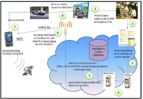
The number of flows in Figure 3.7 describes the flow of data being retrieved using SMS, interaction between application server and database, Internet and the way information is returned to the user. The call centre agents will record the call and stored the information into emergency database. The application which is hosted in an application server will generate short message service and send them based on the user’s location. User’s location is tracked using GPS and should matched with the message location to ensure the correctness of the recipient. After the user received the message, he will proceed with rescuing the victim based on his location.
CONCLUSION
The existence of web services is considered as a part of important element for rendering the information for this mobile application prototype; Emergency Finder. The information will always be updated based on the information feeds from the web based system at the call centre site and are retrievable according to the user location based. In this paper, we have proposed the usage of Pull and Push Location Based Service as a basis for the architecture of providing emergency Location Based Service.
ACKNOWLEDGMENT
This research was supported by UTeM (Universiti Teknikal Malaysia Melaka). The authors also wish to express their gratitude towards Royal Malaysia Police, Malaysia Fire and Rescue Department for their continuous support on this research. We would like to thank the reviewers for their suggestions to improve this paper.
REFERENCES
[1]Tongyu Zhu; Yuan Zhang; Fei Wang; Weifeng Lv(2010).”A Location-Based Push Service Architecture with Clustering
Method.”Networked Computing and Advanced Information
Management (NCM), 2010 Sixth International Conference on
[2]Dr Rosidah Ibrahim(2010).”Communication System In Emergency Medical And Trauma Services Ministry of Health.”
[3]T D’ Roza and G Bilchev (2004).” An Overview of Location Based Services, Location and Personalisation:Delivering Online and Mobility Services.”British Telecommunication Plc.p20-27
[4]Adams, P. M., G. W. B. Ashwell, R. Baxter. (2004).” Location-Based Services — An Overview of the Standards.” p34-43
[5]Health Information and Quality Authority(2011), Pre-hospital Emergency Care Key Performance Indicators for Emergency Response Times.
[6]Jeong Young Sik;Joo Su Chong; Jeong Chang Won(2010).”Mobile Collaboration Environment Based on Distributed Object Group Framework for u-Hospital.” Ubiquitous Information Technologies and Applications (CUTE), 2010 Proceedings of the 5th International Conference on, pg.1-5
[7]Subhankar Dhar; Upkar Varshney(2011),”Challenges and Business Models for Mobile Location-based Services and Advertising.” Communications of the ACM
[8]Jonathan D.Mayer(1980),"Response Time and Its Significance in Medical Emergencies",Geographical Review,American Geographical Society
[9]Appendix D: Emergency Response Time and Coverage Models
[10]GIS for Fire Station Locations and Response Protocol, An ESRI® White Paper