BORANG PENGESAHAN STATUS TESIS
JUDUL: SATELLITE IMAGE CLASSIFICATION USING FUZZY LOGIC TECHNIQUE.
SESI PENGAJIAN: SESI 2012/2013
Saya LEOW THING FUNG mengaku membenarkan tesis (PSM/Sarjana/Doktor Falsafah) ini disimpan di Perpustakaan Fakulti Teknologi Maklumat dan Komunikasi dengan syarat-syarat kegunaan seperti berikut:
1. Tesis dan projek adalah hakmilik Universiti Teknikal Malaysia Melaka.
2. Perpustakaan Fakulti Teknologi Maklumat dan Komunikasi dibenarkan membuat salinan untuk tujuan pengajian sahaja.
3. Perpustakaan Fakulti Teknologi Maklumat dan Komunikasi dibenarkan membuat salinan tesis ini sebagai bahan pertukaran antara institusi pengajian tinggi.
4. ** Sila tandakan (/)
_____________ SULIT (Mengandungi maklumat yang berdarjah keselamatan atau kepentingan Malaysia seperti yang termaktub di dalam AKTA RAHSIA RASMI
1972)
_____________ TERHAD (Mengandungi maklumat TERHAD yang telah ditentukan oleh organisasi/badan di mana penyelidikan dijalankan)
_____/_______ TIDAK TERHAD
__________________________ ___________________________ (TANDATANGAN PENULIS) (TANDATANGAN P ENYELIA)
Alamat tetap :302-1-8 Taman Green Field En.Othman bin Mohd ___ 11500, Air Itam, Pulau Pinang, Nama Penyelia
Malaysia
SATELLITE IMAGE CLASSIFICATION USING FUZZY LOGIC TECHNIQUE
LEOW THING FUNG
This report is submitted in partial fulfillment of the requirement for the Bachelor of Computer Science (Computer Networking)
FACULTY OF INFORMATION AND COMMUNICATION TECHNOLOGY UNIVERSITI TEKNIKAL MALAYSIA MELAKA
i
DECLARATION
I hereby declare that this project entitled
SATELLITE IMAGE CLASSIFICATION USING FUZZY LOGIC TECHNIQUE
is written by me and is my own effort and that no part has been plagiarized without citations
STUDENT: ___________________________ DATE: _________________ (LEOW THING FUNG)
DEDICATION
I would like to say thank you for those who involves for helping me to complete this project. First of all, I would like to say thanks you to my supervisor, En. Othman bin Mohd who helps me a lot to accomplish this project. Without his helps, I will not able to complete this project.
Next, I would like to thanks to my family for encourage me to complete this project when I faced difficulty to complete this project. They understand the stress and the busy that I faced while doing this project and always encourage me to complete this project.
iii
ACKNOWLEDGEMENTS
ABSTRACT
v ABSTRAK
TABLE OF CONTENTS
CHAPTER SUBJECT PAGE
DECLARATION i
DEDICATION ii
ACKNOWLEDGMENT iii
ABSTRACT iv
ABSTRAK v
TABLE OF CONTENTS vi
LIST OF TABLES ix
LIST OF FIGURES x
LIST OF ABBREVIATIONS xiii
CHAPTER 1 INTRODUCTION
1.1 Project Background 2
1.2 Problem Statements 3
1.3 Research Questions 4
1.4 Objectives 4
1.5 Scopes 5
1.6 Project Significance 5
1.7 Expected Output 6
1.8 Report Organization 6
1.9 Summary 7
vii
2.1 Introduction 9
2.2 Related Work 10
2.3 Analysis of Current Problem 13
2.3.1 Justification 14
2.4 Proposed Solution 15
2.4.1 Further Project 16
2.5 Summary 17
CHAPTER 3 METHODOLOGY
3.1 Introduction 18
3.2 Project Methodology 18
3.2.1 Overall Methodology 19
3.2.2 Methodology 20
3.2.3 Classify Binary Decision Tree 21
3.2.4 Flowchart Process 22
3.3 Project Schedule 24
3.3.1 Gantt Chart 24
3.3.2 PSM 1 Milestone 29
3.3.3 PSM 2 Milestone 30
3.3.4 Activities Milestone in PSM 1 31 3.3.5 Activities Milestone in PSM 2 33
3.4 Summary 34
CHAPTER 4 PROJECT IMPLEMENTATION
4.1 Introduction 35
4.2 Hardware and Software Requirement 36
4.2.1 Software Requirement 36
4.2.2 Hardware Requirement 37
4.3 Design 37
4.3.1 Unsupervised Classification Process 39 4.3.2 Fuzzy Inference System (FIS) 39 4.3.3 Range Value for Inputs 41
4.3.4 Mamdani’s Output 41
4.3.6 Rules for Classification 43
4.4 Implementation 44
4.4.1 Mamdani-type System 45
4.4.2 Sugeno-type System 50
4.5 Summary 55
CHAPTER 5 TESTING
5.1 Introduction 56
5.2 Testing 57
5.2.1 Mamdani-type System 57
5.2.1.1 Mamdani Output Result 61 5.2.2 Sugeno-type System 64 5.2.2.1 Sugeno Output Result 69 5.2.3 Comparison between outputs of Mamdani method 72
and Sugeno method
5.2.4 Count Number of Classified Pixel 74
5.3 Summary 75
CHAPTER 6 PROJECT CONCLUSION
6.1 Introduction 77
6.2 Summarization of Objectives
6.3 Observation on Weaknesses and Strengths 78
6.3.1 Strength 79
6.3.2 Weakness 79
6.4 Future Work 80
6.5 Summary 80
REFERENCES 81
APPEDICES A 85
APPEDICES B 89
APPEDICES C 92
ix
LIST OF TABLES
TABLE TITLE PAGE
Table 1.1 Research Problems 3
Table 1.2 Research Questions 4
Table 1.3 Research Objectives 4
Table 3.1 PSM 1 Milestone 29
Table 3.2 PSM 2 Milestone 30
Table 3.3 PSM 1 Activities 31
Table 3.4 PSM 2 Activities 33
Table 4.1 Software Requirement 36
Table 4.2 Hardware Requirement 37
LIST OF FIGURES
FIGURE TITLE PAGE Figure 3.1 Overall Methodology 19 Figure 3.2 Methodology of Image Classification 21 Figure 3.3 Binary Decision Tree Classifier 22
Figure 3.4 Flowchart Process 23
Figure 3.5 Gantt chart for PSM 1 26 Figure 3.6 Gantt chart for PSM 2 28 Figure 4.1 Flowchart of Unsupervised Classification 38 Figure 4.2 Basic flow of Fuzzy Inference System 40 Figure 4.3 Graph of Pixel Value for Band 1, 2 and 3 44
Figure 4.4 FIS Editor 45
xi
Figure 4.17 Rule Viewer for Sugeno-type system 54
Figure 5.1 Value of Output 58
Figure 5.2 Output in array form 59 Figure 5.3 Value of cell array C 59 Figure 5.4 Pseudocode for displaying classified pixels by color 60 Figure 5.5 Image of classification-Mamdani (6 classes) 61 Figure 5.6 Classification of road (Mamdani) 61 Figure 5.7 Classification of land (Mamdani) 62 Figure 5.8 Classification of tree (Mamdani) 62 Figure 5.9 Classification of shadow (Mamdani) 63 Figure 5.10 Classification of building (Mamdani) 63 Figure 5.11 Classification of river (Mamdani) 64
Figure 5.12 Value of Output1 66
LIST OF ABBREVIATIONS
ALPHABET WORD EXPLANATION
A ANFIS Adaptive Neuro Fuzzy Inference System C CPG Classification by Progressive Generalization F FIS Fuzzy Inference System
F FKM Fuzzy K-Means
M MISO Multiple Input Single Output M MIMO Multiple Input Multiple Output
I ISODATA Iterative Self-Organizing Data Analysis Technique
P PID Process ID
R RO Research Objective
R RP Research Problem
R RQ Research Questions
T T-S Tagaki-Sugeno
CHAPTER I
INTRODUCTION
1.1 Project Background
In general, classification refers to learning classification models or classifiers from data presented by labeled examples (Valentina Zharkova, 2007). Image classification is processing techniques which apply quantitative methods to the values in a digital yield or remotely sensed scene to group pixels with similar digital number values into feature classes or categories (Purdue University , 2012). Image classification can also called a process which grouped the items (objects/patterns/image/regions/pixels) based on the similarity between the item and the description of groups.
Common classification procedures can be broken down into two broad subdivisions based on the method used: supervised classification and unsupervised classification.
Supervised classification is the process of automatically grouping data into a set of classes by setting up prototypes using a priori knowledge obtained through training. It often involves selection of training data that can represent homogeneous examples of each class (Chen, 2010).
Unsupervised classification is one of the two basic approaches to digital image classification with the goal of producing land cover maps from remotely sensed data. Unsupervised algorithms evaluate the spectral properties of image pixels and segregate them into naturally occurring statistical groups with little or no guidance from the analyst (Rundquist, 2010).
The advanced methods that can be used in supervised classification include Parallelepiped Classification Maximum Likelihood Classification, Minimum Distance Classification and Endmember Spectra. As for unsupervised classification, the advanced methods that can be used in unsupervised classification method are K-Means Classification and ISODATA classification.
3
Technique will be done. In this project, the chosen method is Fuzzy Mamdani and Fuzzy Sugeno for unsupervised image classification.
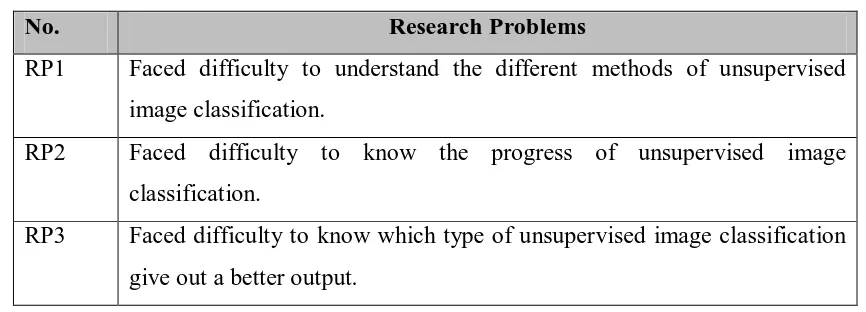
1.2 Problem Statements
Nowadays we use satellite to do many things. One of the usages is to capture image on the earth. However, it is difficult to differentiate the objects captured by satellite on the ground. Although different types of techniques are used to classify the image, we do not know which type of method to be implemented is better. The problem statements are listed and can be summarised as Table 1.1.
Table 1.1 Research Problems
No. Research Problems
RP1 Faced difficulty to understand the different methods of unsupervised image classification.
RP2 Faced difficulty to know the progress of unsupervised image classification.
RP3 Faced difficulty to know which type of unsupervised image classification give out a better output.
1.3 Research Questions
In this study, the research question was identified based on the problem that has been classify in paragraph 1.2. The research question are listed as follow:
Table 1.2 Research Questions
RP RQ Research Questions
RP1 RQ1 What is the difference between different types of unsupervised image classification method?
RP2 RQ2 How did the method of unsupervised image classification works? RP3 RQ3 Which type of unsupervised image classification method gives
out a better output?
Based on the research problem that had been list out in paragraph 1.2, three questions were written out to analysis and solve the problems. For RQ1, this research question was to get the better understanding on different types of unsupervised image classification. For RQ2, this research question was to know the progress and the function of selected methods. Finally for RQ3, this research question was to select the best method for unsupervised image classification.
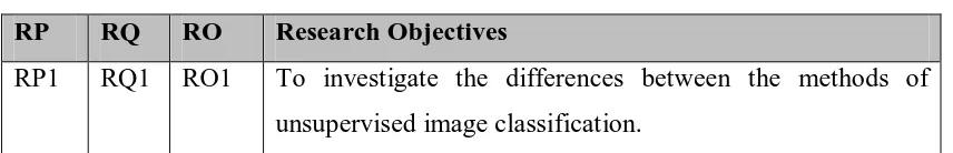
1.4 Objectives
The objectives were listed out based on the research problems and questions as stated in Table 1.1 and Table 1.2. The objectives were listed as shown in Table 1.3 below.
Table 1.3 Research Objectives RP RQ RO Research Objectives
5
RP2 RQ2 RO2 To classify how the unsupervised image classification works out.
RP3 RQ3 RO3 To compare which type of unsupervised image classification gives a better output.
Based on the research problem and research question that summarised in Table 1.1 and 1.2, a summarised of research question which is Table 1.3 was listed. There are three main objectives that were listed. For RO1, this objective was important to do the comparison between the methods for understand the differences between the methods. As for RO2, this objective was important to know the flow and progress of the method chosen when doing the unsupervised image classification. And as for RO3, this is important to choose the best method which can produce better image for image classification.
1.5 Scopes
The scope of this project was the comparison of unsupervised image classification between Mamdani-type and Sugeno-type classification. In this study, the main area had been identify, and the image used for this study was captured by the satelite. The image was from Malaysia Remote Sensing Agency which using size of 225 x 277 pixels on 256 bits or unsinged integer 8 from QuickBird Satellite Image for June 2010 of Kuala Linggi Mangroves Forest, Alor Gajah Melaka. The software used was Matlab R2009a to do the image compression. Fuzzy logic was used in order to do the comparison between Mamdani-type and Sugeno-type classification.
1.6 Project Significance
structures, within multi-spectral data by the algorithms programmed into the software. In order to do unsupervised classification, spectral classes are grouped first, based solely on the numerical information in the data, and are then matched by the analyst to information classes. This study would be beneficial on geography field. By implement this image classification, this could help the geographer to classify out the object captured and apllied on the map for more accurately.
1.7 Expected Output
In this project, the two of method of unsupervised image classification which is Mamdani-type and Sugeno-type classification was being compared to obtain the best result. The Mamdani-type image classification would be getting a better result as compare to Sugeno-type image classification. The Mamdani method should be classified out the better result on the pixels as compared with Sugeno method.
1.8 Report Organization
In report organization, the overall project was divided into six main chapters. In Chapter I, the discussed topics included project background, problem statements, research questions, objectives, scopes, expected output and report organization.
As for Chapter II, the topics covered included literature review, related works, analysis of current problem and justification, and proposed solution. The analysis of the problem was used to do as the project objectives and ways of solution was proposed to solve the problems.
7
For Chapter IV, the topics covered included implementation. The required hardware and software requirement was listed into table and the flowchart for the process of method was drawn. The FIS system for both Mamdani method and Sugeno method was built.
For Chapter V, the topics covered included the testing on the system. The linking between FIS system and image was tested. The classified pixel that belongs to different classes was displayed in different color. The output for both methods was compared. Besides that, the total number of classified pixels was also been counted.
For Chapter VI, the topics covered included conclusion, observation on weakness and strengths, future works and summarization of project objectives was included. The overall summarization for this project was included in this chapter.
1.9 Summary
In conclusion, there are two types of image classification which is supervised and unsupervised classification. Unsupervised image classification was selected to do this project. There are various types of method for unsupervised image classification such as L-Means and ISODATA classification. In this project, the methods used for unsupervised image classification were Mamdani-type and Sugeno-type classification.
In order to do this project, the research problem were listed out such as facing difficulty to understand the different methods of unsupervised image classification, difficult to know the progress of unsupervised image classification and difficulty to know which type of unsupervised image classification give out a better output. The next chapter will cover more details of this project which included literature review and project methodology.
differences between the methods of unsupervised image classification, to classify how the unsupervised image classification works out and to compare which type of unsupervised image classification gives a better output.
By implement this image classification, this could help the relevant person or agencies such as geographer to classify out the image and draw out the map easily. In this project, two techniques of fuzzy were used to compare the best classification output of the satellite images.
CHAPTER II
LITERATURE REVIEW
2.1 Introduction
In the previous chapter, the topic included were the project background, problem statement, research questions, objectives, scopes, project significance and expected output. In order to further discover more on the topic chosen, more topics would be discovered. In this chapter, the topic of the related work or previous work, analysis of current problem or justification and proposed solution was included.
The related work or previous works was included in this chapter. This includes the research and comment that had been done before. The facts that was related was included. This was important for understanding the idea or topic that studied. It can be used for reference and can helped as a guidance when doing this project. The literature review can helped to enlarge the area of knowledge field that being studied. Besides that, the advantages of the chosen method was covered also in this chapter. This is to ensure the benefits of applying the knowledge related.
By figured out the current problem and doing the justification, the solution to overcome the problem can be done. The current problem was list out by analyze listing out the problem that had been faced. The justification was done by analyze the problem listed and give out solution to overcome that problems.
In order to understand and complete this project, research and problem analyze was important to realize the current stage of understanding on the related topic area. By having a good knowledge on the topic covered, this can helped to obtain the results that expected.
2.2 Related Work
Image classification is an important part of the remote sensing, image analysis and pattern recognition. In some instances, the classification itself may be the object of the analysis. For example, classification of land use from remotely sensed data produces a map like image as the final product of the analysis (Campbell, 2011).
The comparison between the two chosen method is doe based on a given satellite image. Satellites images consist on layers, each layer have special information regarding the satellite specialization directives. For instance, in the Landsat satellite images (specialized in weather forecasting); layer 1 may have water information, layer 2 reports soil information, etc. Each of these layers is in fact a pixel matrix, which can be easily converted into a matrix of real number values. The matrices store specific information corresponding to each color related to the terrain surface at a given location (Susana Arias, 2009).