The stratigraphy and fire history of the Kutai Peatlands,
Kalimantan, Indonesia
Geoffrey Hope
a,*, Unna Chokkalingam
b, Syaiful Anwar
ca
Archaeology and Natural History, RSPAS, Australian National University, Canberra 0200, Australia
b
Center for International Forestry Research, Bogor, Indonesia
c
Department of Soil Science, Bogor Agricultural University, Indonesia
Received 1 March 2005 Available online 30 September 2005
Abstract
The equatorial peatlands of the Kutai lowland of eastern Kalimantan are generally 4 – 10 m in thickness but some sections exceed 16 m in depth. The deposition of peat commenced about 8000 yrs ago after shallow flooding of the basin by the Mahakam River. The earliest vegetation is aPandanus swamp which grades upwards to swamp forest dominated by dipterocarps. The peatland has expanded laterally and rivers have maintained narrow levee-channel tracks through the swamp, which has grown vertically in balance with river accretion. Historical fires are associated with extreme El Nin˜o yrs of drought, but human agency is important. The fires of 1982 – 1983 and 1997 – 1998 burnt up to 85% of the vegetation on the peatland. Although charcoal analyses show that fire has occurred throughout the history of the peatland, it is rare in forests remote from rivers until the last 3000 yrs and only common within the last millennium. Fires are earlier and more frequent in sites accessible from waterways, and floodplains have been widely burnt down to water table or below, forming extensive lakes.
D2005 University of Washington. All rights reserved.
Keywords:Tropical peatland; Fire history; Charcoal analysis; Palaeolimnology
Introduction
Since the 1980s, large-scale fires in the peatlands of western Indonesia have caused serious damage in terms of biodiversity loss and there is global concern over the smoke plumes and carbon emissions arising from peatland burning (Nichol, 1997; Page et al., 2002). The peatlands of the Kutai Lowlands in East Kalimantan province, Indonesia have been subject to repeated burning in the last two decades. Up to 45% of the swamp forest was affected in 1982 – 1983 and 72 – 85% in 1997 – 1998 by fires lit during unusually dry summers. The 1997 – 1998 fire event removed almost all standing trees over thousands of hectares, leaving scrub and sedge successional communities. How do these recent fires compare with the long-term fire history of these peatlands? Are they unusual events and what are the implications for forest and peatland recovery? This paper reports preliminary observations on the stratigraphy and
fire history of the peat, supported by limited palynology and dating. No previous studies of the Kutai peatland sediments have been made although lowland tropical peatlands elsewhere in the region have been studied (e.g., Anderson, 1964; Anderson and Muller, 1975; Anshari et al., 2001, 2004; Morley, 1981a,b; Neuzil, 1997; Page et al., 1999; Rieley and Page, 1997; Staub and Esterle, 1994; Supardi et al., 1993; Taylor et al., 2001; Wu¨st and Bustin, 2004).
Setting of the Kutai Peatlands
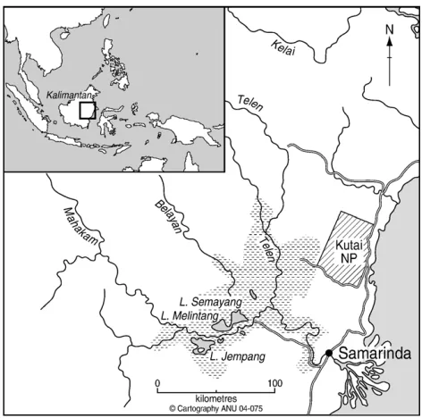
The Kutai peatlands differ from those of Central Kalimantan (Page et al., 1999; Rieley and Page, 1997), and Sumatra (Neuzil, 1997) in occupying an inland basin whose hydrology has been controlled by river accretion. The Kutai Lowland (centred on 00-12VS, 116-15VE) is 80 km inland, bounded to the east by a range of soft sandstone hills (Fig. 1). The lowland is 35 km NW – SE by 130 km SW – NE, rising northwest from its lowest point around sea level on the Mahakam River to ca. 24 m a.s.l. Silty clay channel and levee systems of the Mahakam River and narrower levees of its major tributaries
0033-5894/$ - see front matterD2005 University of Washington. All rights reserved. doi:10.1016/j.yqres.2005.08.009
* Corresponding author. Fax: +61 2 61254917.
E-mail address:[email protected] (G. Hope).
from the north cross the lowland. Behind the levees are a series of large shallow lakes and seasonally inundated peat plains which grade into forested peatlands that rise gently to meet sandy slopes to the northwest and east.
The climate of the area is tropical seasonal, with the mean temperature range between 25-– 30-C yr round and 1900 – 2000 mm of rain mostly falling from December to April (Weidemann, 2002). In the wet season the lakes and rivers expand, flooding the neighbouring peatlands to depths of up to 3 m. Rivers and lake levels fall by 5 – 6 m in the dry season, which extends roughly from July to September. Burning of sedge-grasslands is widespread at this time, and fires can spread into the peatland forests. During marked El Nin˜o yrs the December – April rains fail and the dry season can extend for up to 8 – 12 months (Brookfield et al., 1995). At such times, the peatland surface can dry and fire hazard is greatly increased.
The natural vegetation of the peatlands is a mosaic of specialised closed forests that reflect the hydrology, nutritional status and disturbance history of a given site. Key taxa in disturbed areas are Shorea balangeran (Dipterocarpaceae),
Combretocarpus rotundatus (Anisopteraceae) and Syzygium lineatum (Myrtaceae). Less disturbed forests have a higher diversity of tree species such as Dactylocladus stenostachys,
Licania splendens, Campnosperma coriacea and Shorea teijsmaniana. Peatland plants are adapted to waterlogging, low pH and poor substrate nutrition with many displaying a mass of rootlets and mycorrhizae that recycle nutrients, and maintain very acid conditions.
Unlike primary rainforests, swamp forest is rarely taller than 25 m with trunk diameters less than 80 cm. The less disturbed forests have very high stem density up to 2000 – 3000 stems/ha. Plains within 0.5 – 3 km of rivers and lakes have lost their tree cover due to annual fires and support sedgelands or grasslands. However, a large part of the landscape is now in successional vegetation types following the fires of 1997 – 1998.
Relatively low populations of Kutai and Banjar ethnic groups live in scattered villages along the clay levees or lake shores. At present, limited cultivation occurs on the alluvial floodplains and levees and the main activity is fishing. Historically, the area was controlled by the sultanate of Kutai. Carl Bock, who visited the area in 1879, described only a very sparse population but noted widespread defoliation resulting from the prominent drought of A.D 1879 – 80 (Bock, 1985). The peatland forests are very difficult to cross on foot and only the margins are visited regularly for fishing, although in the wet season boats can go some distance into the forest.
Methods
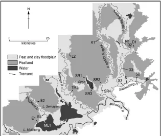
During August – September 2001, line transects covering roughly 24 km were laid out at 18 locations across the slightly domed peatlands, riverine plains and peat lakes. A Russian D section corer was used to take cores at 200-m intervals along these transects (Fig. 2). The transects sampled a range of spectral signatures in a yr 2000 LANDSAT image (Path/Row 117/060) to relate these to site types and disturbance histories. Difficulty of access meant that the marginal peatlands were over-sampled by comparison with the interior sites. Any evidence for recent fire effects such as burnt hollows, charcoal or successional vegetation was noted.
Peat was described in terms of colour, pH, content of fibrous debris and wood, degree of preservation and mineral content. Charcoal in the sections was identified in the field by sieving peat with a 1-mm sieve and examining the debris carefully, crushing possible fragments to check for carbonisation. Care was taken not to misidentify stained wood and dark bark fragments. Where doubt existed, the sample was bagged for later microscopic examination. These visual methods probably only locate fairly marked local fires and may miss some burning events, since charcoal is not preserved everywhere after fire.
Basal clays from eight cores were selected for characterisa-tion with X-ray diffraccharacterisa-tion. Surface and mid-profile samples of clays were also taken from Lake Melintang. Samples of peat were taken from selected sections in seven cores to allow radiocarbon dating of base and intermediate levels, including those at which macro-charcoal was detected. In the laboratory, radiocarbon samples were sieved and the <1-mm fraction treated with 10% HCl, and NaOH to remove humates and soluble organic debris.
To obtain a rough measure of local fire (Haberle et al., 2001), micro-charcoal was sampled from six cores that represented a range of site types from remote peatlands to near river and sub-lacustrine cores. Core samples of 0.75-ml were sieved through 120- and 10-Am nylon mesh. The >120-Am fraction was retained and examined for macro-charcoal under a low-power microscope. The intermediate sample was suspended in 5 ml of water with a few drops of bleach and 10Al pipetted out and mounted on a slide. Fifty fields were
immediately examined at 250 using a point-counting
technique for microscopic charcoal (Clark, 1982). This provides a quantitative estimate of charcoal concentration
Figure 1. Location of the Kutai study region.
G. Hope et al. / Quaternary Research 64 (2005) 407 – 417
(mm2of charcoal per ml of original sediment). An effort was made to count only clearly carbonised plant material, but some non-burnt dark matter may have been included, hence very low concentrations are not evidence for past fire.
Three sites were additionally sampled for pollen, E2P23, K1P17 and MLT1. Pollen was extracted from 1.5 ml of sediment by sieving through 120-Am mesh and the finer material given standard acid, alkali and acetolysis treatment. Hydrofluoric treatment was only used on samples from clay-rich horizons. Pollen percentages were calculated on a total pollen sum of all pollen and fern spores. The slides were fairly poor in pollen but contained abundant cuticle fragments, fungal spores, algal cells and cysts. Inaperturate sedge and some grass pollens were undoubtedly under-counted because of their similarity to extremely abundant algal or fungal cells.
Results
Stratigraphy
The peatland surfaces rise away from rivers and lakes towards the uplands to the northwest and east with large plateaux in middle sections. In general the greatest peat depths (>7 m) occur inland from the riparian zones and lakes of the three large peat masses to the west and near the village Sabintulung to the east (Fig. 2). Peat surfaces in most sections tend to follow the sub-peat contours and slopes, filling in the basins and valleys and becoming shallower up slope. Average peat depth is 8 m with the maximum encountered being >16 m. The peat usually consists of a rootmat over very watery sapric peat. Underlying this is wood meal or fibrous peat with layers of amorphous (hemic) peat. Fragments of wood and logs
are abundant in the peat, usually in a partially rotted state. Below this woody peat is a layer of clayey fibrous peat and peaty clays, with abundant monocotyledon leaf remains, possibly from Pandanus and sedges. These basal peaty clays tend to be thickest in floodplain and lacustrine sites. More remote peatlands or those formed above sea level have sapric to hemic peat which changes abruptly to bleached white or grey clays and very fine clayey quartz sands. The lakes and some floodplain sites have upper layers of clay or peaty clay.
The pH of the main peat column is 4 to 5.5 while the clay-rich peats are pH 5 – 6. Basal peaty clays are generally pH 6.0 – 6.5 but some samples are pH 7.5 – 8.0. Living fauna, possibly nematodes or amoebae, were seen moving about slides in a few samples of deep peats even after several months of storage. Thus, the peat has some biological activity through much of the profile and is not strongly reducing.
The clays in all selected sections contain a very similar mineral suite dominated by kaolin (Table 1). The presence of less weathered clay (smectite) and regolith minerals such as chlorite and mica suggests a fluvial source derived from an eroding catchment. Sabintulung is close to bedrock topograph-ic highs and may contain locally weathered sandstones as well as more widely derived riverine sediment. The EMS analysis of samples from Kupang Baru K1P17 revealed high levels of Al, Ca, K and Si in the basal clayey peats at 940 cm, but all samples above this were extremely low in these elements suggesting little further inputs from floods at this site as the peat bog grew. In the section from Lake Melintang, clay horizons at the surface and at 470 cm both show a close resemblance to the basal clays. This suggests that they came from flooding by the Mahakam River into the basin. Similarly, the basal clays from separate transects near Lake Siran, which
is controlled by the Kedang Kepala River, and from a transect west of the river levee are close matches. Thus, the clays encountered reflect flooding by clay bearing waters derived from the major river systems.
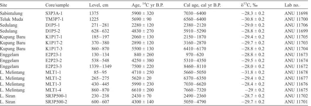
Dating
The radiocarbon dates (Table 2) from basal sediments are largely derived from permanently flooded swamps in which nutrient recycling was probably not active. However, the dates from higher levels should be regarded as minimum dates for those levels due to the possibility of some carbon exchange from the active root zone following deposition.
The oldest dates are generally from the deeper sections at the lowest altitudes close to the Mahakam River. The base of the peats in Lake Melintang, the proximate Enggelam peat-lands to its west and the section from Sabintulung is about 5 – 10 m below present mean sea level. The basal dates and the occurrence of peat below modern sea level suggest that flooding of the basin commenced when sea level was
approaching present levels about 8000 yr ago (Hesp et al., 1998). There is no sign (such as mangrove pollen) that the sea itself reached the Kutai basin at this stage, but the flow of the Mahakam was backed up, gradually encroaching on the sandy plain beyond the river as a shallow muddy lake. At its delta, the river has infilled over 100 m over the last 15,000 yr (Caratini and Tissot, 1988). Although the dating resolution is low, peat growth seems to have been more or less continuous since initiation. Inferred calibrated time scale ages used below are based on a simple model of continuous accumulation between dated levels, which may conceal considerable discrepancies.
Depositional rates and changes
The most rapid accumulation of peat, 40.8 cm/100 yr, was found in the section beneath Lake Melintang (Table 3) which built up under a flooded forest. The two lowest rates found are from sites well away from the influence of major rivers. This may reflect the relative availability of nutrition derived from river sources. The dated Enggelam P23 section (24 to 12 cm/
Table 2
Carbon dates from Kutai lowlands, Kalimantan Timur, Indonesia
Site Core/sample Level, cm Age,14C yr B.P. Cal age, cal yr B.P. y13C,° Lab no.
Sabintulung S3P3A-1 1375 5900T320 7030 – 6400 28.3T0.2 ANU 11698
Teluk Muda TM3P7-1 1225 5690T90 6560 – 6400 30.8T0.2 ANU 11700
Sedulang D1P5-1 271 – 281 2280T120 2380 – 2120 29.0T0.2 ANU 11706
Sedulang D1P5-2 628 – 632 4830T270 5910 – 5290 28.8T0.2 ANU 11699
Kupang Baru K1P17-1 185 – 197 2060T130 2150 – 1870 29.4T0.2 ANU 11705
Kupang Baru K1P17-2 370 – 380 2890T120 3160 – 2870 29.7T0.2 ANU 11703
Kupang Baru K1P17-3 860 – 870 5500T130 6410 – 6170 28.8T0.2 ANU 11704
Enggelam E2P23-1 130 – 134 840T260 970 – 620 28.8T0.2 ANU 11673
Enggelam E2P23-2 538 – 548 4250T380 5310 – 4350 29.5T0.2 ANU 11674
Enggelam E2P23-3 1339 – 1349 7500T220 8460 – 8110 28.0T0.2 ANU 11672
L. Melintang MLT1-1 85 – 95 4710T250 5660 – 5050 31.8T0.2 ANU 11678
L. Melintang MLT1-2 265 – 275 5620T20 6370 – 6350 29.4T0.2 ANU 11677
L. Melintang MLT1-3 430 – 445 5990T230 7030 – 6620 28.4T0.2 ANU 11676
L. Melintang MLT1-4 860 – 870 6610T200 7660 – 7320 29T0.2 ANU 11675
L. Siran SR3P500-1 230 – 238 2430T70 2490 – 2360 28.7T0.2 ANU 11702
L. Siran SR3P500-2 600 – 607 4300T140 5050 – 4790 29.7T0.2 ANU 11701
Dating on acid-base-acid washed residues, obvious roots removed. Calibrated calendar-age ranges based on 1-sigma intercepts derived from CALIB 4.3 (Stuiver et al., 1998).
Table 1
Mineralogy of clays from selected peat sections
Site Depth (cm) Mineralogy
Mahakam Source Area
Lake Melintang 005 Kaolin, mica, chlorite, vermiculite, vermiculite/mica (random interstratified), quartz Lake Melintang 470 Kaolin, mica, chlorite, vermiculite, vermiculite/mica (random interstratified), quartz Lake Melintang 900 Kaolin, vermiculite/mica (random interstratified), mica, quartz
Enggelam E1P7 1250 Kaolin, vermiculite/mica (random interstratified), mica, smectite, quartz Enggelam E2P9 1535 Kaolin, smectite, vermiculite/mica (random interstratified), quartz
Kedang Kepala River Source Area
Kupang Baru K1 P17 940 Kaolin, mica, chlorite, smectite, chlorite/mica (interstratified), quartz
Siran SR1P3 944 Kaolin, smectite, mica, chlorite, vermiculite, smectite/mica (random interstratified), quartz Siran SR2P3 945 Kaolin, mica, chlorite, smectite/mica (random interstratified), quartz
Siran SR3P4 995 Kaolin, smectite, mica, chlorite, vermiculite, chlorite/mica (interstratified), quartz
Kedang Rantau River Source Area
Sabintulung S2 750 Kaolin, smectite, chlorite/mica (interstratified), mica, vermiculite, quartz
G. Hope et al. / Quaternary Research 64 (2005) 407 – 417
100 yr) and Lake Melintang section (68 to 45 to 20 cm/100 yr) suggest a slowing of accumulation as the peat developed above base level. Such slowing is not discernible in the Kupang Baru P17 core, where clay levee and channel accretion by the Kedang Kepala River may have raised the base level through time. Evidence for the truncation of profiles was seen on Lakes Melintang and Siran; and on the Enggelam E4 and parts of Sabintulung D3, S1, S2, S3 transects where peat now forms level plains adjacent to the rivers (Fig. 2). The stumps of trees are visible in section, having burnt, with the peat, down to the water table. Within 0.6 km of rivers in other transects such as SR2, TM3, D2, N1 and D1, up to several metres of peat are buried beneath clay or mixed peat/clay layers of generally 0.3 to 2 m thickness. In site S3, this depositional change continues to 1.1 km from the river. The edges of lakes Melintang and Siran also have surface clay layers 0.3 and 1.6 m thick respectively above the peat profile. This major change in deposition must reflect damage to the peatlands and the peatland vegetation, which has allowed turbid stream water to flood onto the peat, when previously the flow was contained by the riparian vegetation and higher peat surfaces.
Charcoal and pollen
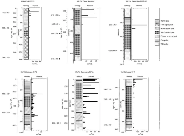
Substantial bands of macro-charcoal were found in the upper 100 cm and 200 cm of 85% and 33% of the cores respectively, suggesting that firing has become more common within the past 1500 yr or less (Table 4). Below this zone, macro-charcoal was rarely encountered in significant layers and only 7% of the cores had macro-charcoal below 500 cm depth (roughly 2500 yr ago). The concentrations of micro-charcoal from six sites broadly supported the macro-charcoal observa-tions. However, the sampling is quite coarse, and hence some micro-charcoal concentrations may have been missed.Figure 3
shows the stratigraphy and charcoal concentrations at each site.
Enggelam E2P23
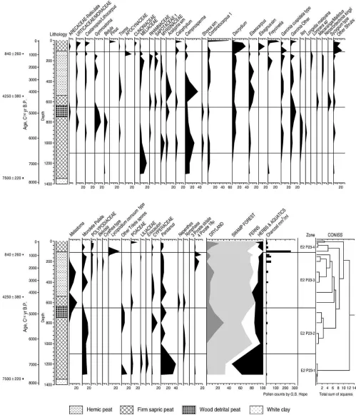
This site is well away from river floods and is a small unburnt patch of shrubs within an area of major fire damage.
The site seems to have been occupied by mature forest (including Dacrydium) until burnt in 1997 – 1998, indicating long-term stability before then. Marked bands of macro-charcoal occurred at 103 – 104, 107 – 112, 125 – 126 and 130 – 133 cm but not deeper in the 1340-cm section. Nearby cores show a similar reduction in charcoal in the top metre. The micro-charcoal record shows a prominent peak at 100 cm with generally low levels above this (Fig. 3), thus agreeing with the stratigraphy in showing that the site has been relatively fire free over perhaps the past 5 – 500 yr. A small rise in micro-charcoal occurs at 5400 cal yr B.P. and again about 3300 cal yr B.P. after which all samples contain charcoal, increasing after 1500 cal yr B.P. towards the largest peak at ca 650 cal yr B.P.
Low resolution pollen analysis suggests that swamp forest has dominated the site over the past 7500 yr (Fig. 4). The pollen diagram shows an early phase of dominance by
Pandanus, ferns, grass, Campnosperma and Meliaceae that may reflect a frequently flooded forest with relatively favour-able nutrition derived from river sediments. There is a transition to a more diverse forest around 1100-cm depth that coincides with a decline of Pandanus. The following phase is marked by the consistent presence of Ilex and Dacrydium.
Campnosperma declines above 900 cm and a range of taxa appear that may be coming from longer distance such as
Gymnostoma and Castanopsis. The long-range taxa may be dominating because of low pollen production of taxa occupy-ing the site. It is possible thatShoreabecame dominant locally at this stage since this genus has very low pollen dispersal and is effectively invisible in pollen diagrams. At 600 cm,
Campnosperma and Elaeocarpus increase and the swamp shrubMelastoma appears, indicating an opening in the forest. There is not much burning recorded in this zone, so possibly other disturbances, such as a wind storm, caused local tree falls. The marked increase in burning above 130 cm correlates with the biggest ecological shift in the record as indicated by the discriminant analysis. Apocynaceae respond immediately, and after an initial fall, Dacrydium reaches its highest levels in the diagram. Lycopodium cernuum, Timonius, Garcinia,
Combretocarpus, Calophyllum, Baccaurea and legumes all show post-fire peaks, indicating that mixed forest has regenerated over open peats in the course of a few decades. On the other hand, Meliaceae, Sapotaceae, Gymnostoma and
Garcinia become rarer or locally extinct after fires have been experienced but before the marked charcoal horizon at 110 cm.
Kepala K1P17
This 910-cm core was taken in a mature peat forest burnt in 1997 – 1998 and located 2 km west of the Kedang Kepala River. The peat surface is a metre or so above the maximum river flood level, and peat through the profile is woody with
Table 4
Macro-charcoal observed by depth in all sections
Section depth, cm
0 – 100 100 – 200 200 – 300 300 – 500 >500 – 1500 Total cores
% cores with macro-charcoal 85% 33% 15% 9% 7% 95
Table 3
Raw peat accumulation rates for dated peat sections
Site Section
L. Melintang MLT1 775 1900 40.8
Sabintulung S3P3A 1375 5900 23.3
Teluk Muda TM3P7 1225 5690 21.5
L. Siran SR3P500 370 1870 19.8
Kupang Baru K1P17 674 3440 19.5
Enggelam E2 P23 1212 6660 18.2
Figure 3. Stratigraphy and charcoal analysis from selected sections.
G.
Hope
et
al.
/
Quaternary
Resear
ch
64
(2005)
407
–
417
some sedge peat and clay at 7.4 – 8 m depth. Macro-charcoal was found on the surface and possible pieces were also seen at 340 and 480 cm.
Micro-charcoal was found in the basal peaty clays and in the earliest peat at 5600 cal yr B.P. A small peak occurs at 4400 cal yr B.P. but all samples contain some charcoal after 3200 cal yr
B.P., with higher values at 2800 cal yr B.P. and at 120, 100, 50 and 1 cm where the highest carbonised particle concentrations of the whole record occur. If the peat continued to accumulate to the surface at the same rate as that between 2900 and 2050 cal yr B.P. then ages of 1750, 1650 and 1450 cal yr B.P. can be inferred for the upper peaks and the current peat surface should
be around 1200 yr old. One possibility is that fire has truncated the peat by as much as 260 cm but the mature forest on the site before 1997 shows an absence of recent fires. The estimate of peat loss is a maximum because it is also possible that peat growth has slowed as the peat level rose above the river flood level. There may have been several fires in the upper 120 cm of the section that have each removed smaller amounts of peat, in which case the surface would not be as old but the upper section would preserve several gaps. Pollen shows that this site has supported a very mixed forest throughout its history.
Sedulang D1P5
The 960-cm core was taken 7.5 km east of the Kedang Rantau River and the site is flooded up to 1 m in the wet season. The mature forest on the site was growing on peaty clay with bands of clay down to 270 cm. Below this lies 390 cm of woody peat, becoming clayey near the base and overlying peaty clay and clay. Distinct horizons of macro-charcoal were observed at 270 and 365 cm in the core.
Micro-charcoal occurs in most levels at low concentration, with minor peaks at the top of the basal clays at 5000 cal yr B.P. and the base of the overlying clays at 2400 cal yr B.P., in agreement with the observed macro-charcoal. The results indicate that fire has been common at this site but rarely severe, at least until some time after 2400 cal yr B.P. The abrupt change from peat to clay at 270 cm may represent a peat truncation event that allowed river water to flood in.
Sabintulung S3P3A
This 1500-cm core was taken 800 m north of the Sabintulung River on a broad plain where the trees have been destroyed by repeated annual burning and only sedges and grasses have been able to recolonise. The surface sediment is peaty clay and a prominent horizon of macro-charcoal was found at its base from 27 to 35 cm, suggesting a possibly recent truncation event. Since the amount of peat removed is unknown and because only a basal date is available for this core this event may have occurred in the last several centuries or be quite recent. The peats below this contain abundant wood, suggesting the site has been swamp forest through most of the record.
Micro-charcoal occurs throughout the profile but has relatively lower concentrations in the basal section up to the base of a band of peaty clay at 600 – 687 cm where there is a prominent peak. Levels are mostly high after this to the surface. This change probably occurred around 2500 – 3000 yr ago, and the clay horizon may represent an earlier truncation event at this time analogous to that near the surface.
Lake Melintang MLT1
This large lake is fed by the Enggelam River and flows through a clay levee channel to the Mahakam River 2 km to the south. During the dry season of August 2001, the lake was about 1 m in depth. Flood marks on trees in the shoreline woodland show that the lake expands in the wet season to about 5 – 6 m depth. The 890 cm core was taken in the lake
about 300 m south from the dry season shoreline which is marked by scattered trees. A 20- to 30-cm layer of humic clay overlies deep woody and fibrous peats with a zone of clayey peat between 300 and 500 cm that contains a prominent white clay band at 470 – 480 cm. Clay increases below 820 cm to a
clay base at 880 cm. Sedge and Pandanus remains are
prominent in the peaty clays. Extrapolation past the dated levels from the base to the top of the peat suggests that the peaty sediments built up between 7500 cal yr B.P. and at 5200 cal yr B.P., demonstrating that a major truncation event formed the lake after this time. If peat had continued to accumulate as quickly up to 8 m of peat could have formed in the last 5000 yr. Macro-charcoal was found in the surface 1 – 4 cm and formed a prominent layer near the base of the surface clay at 20 – 25 cm. Less prominent bands occurred at 20 – 55, 65 – 68, 75 and 230 cm. Micro-charcoal is absent from the lower part of the section including the clay layer at 460 cm (Fig. 3). Charcoal first appears at 5700 cal yr B.P. and then has large peaks at 5400 – 5100 cal yr B.P., in good agreement with the macro-charcoal. The sub-clay charcoal may relate to the truncation event while surface charcoal is derived from possible dry season fires that have extended the basin. Local people currently practice rice cultivation when the lake shore is exposed in unusually long El Nin˜o dry seasons. Burnt stumps are common in many places along the edges, apparently in situ, suggesting such expansion with burning in historic times.
Pollen samples show that a mixed swamp forest dominated byCampnospermaandDacrydiumoccupied the site, with high levels ofPandanusand some sedges, indicating that substantial flooding was occurring, particularly in the clay zone in the middle of the core and in the peats towards the base. In the burnt horizon at 120 cm, a more mixed forest is present, with higher levels of Calophyllum, legumes, Ilex and Syzygium. Near the top of the peat at around the 20-cm level only low levels of carbonised particles occur, andPandanusand sedges once again dominate the spectrum indicating that flooding is taking place. At the same level,Ilex,Neoscortechina,Garcinia
and Campnosperma indicate mixed forest, in which Shorea
was probably a major component.
Lake Siran SR3P500
This oval lake is about 9 km long and 3.5 km in width, with an average depth of about 80 cm in the dry season and at least 7 m in the wet season. Water leaves the lake by a narrow 5 km clay channel to the Kedang Kepala River, and also fills from the river at flood times, as shown by a splay delta forming into the lake. Burnt stumps are common in many places, apparently in situ, suggesting that a forest was established in parts of the lake in historic times and then burnt subsequently. All three cores taken within the eastern (channel) side of the lake in a water depth of about 60 – 80 cm have a thick layer of clay, overlying peats. The core (SR3P500) taken in 50-cm depth, 500 m from the south-eastern shore had 160 cm of clay and clayey peat over 400 cm of mostly wood peat and a basal layer of monocot peat with sedge remains above white clay. Peat formation commences about 4700 cal yr B.P. and is truncated at 1730 cal yr B.P.
G. Hope et al. / Quaternary Research 64 (2005) 407 – 417
Macro-charcoal was common in the upper clay/ clayey peat layer at 70, 92, and 125 cm and possible charcoal was seen in the upper levels of the peat at 243 – 246, 295 – 298 and 320 – 332 cm. Only six samples were analysed for micro-charcoal. A sample from the base of the section contains no convincing carbonised particles, and the lower part of the peat layer is also fire free. Fire is apparent by about 3100 cal yr B.P. and it reaches a high level at the base of the clay layer at 2500 cal yr B.P. (Fig. 3). Micro-charcoal at low levels is apparent from one sample in the overlying clayey peat, but the value is very high at 5 cm, reflecting annual burning of grasses on the seasonally flooded zone around the lake. Another lake core, Plot SR3P250, a sample point 500 m away, had macro-charcoal from 6 to 140 cm. This sparse evidence suggests that Lake Siran resulted from fire burning into the peatland within the last 2500 yr. If peat continued to grow at the average rate for the core, up to 3.4 m may have been lost. This sequence resembles that from Lake Melintang, although peat initiation is later, more of the peat column is preserved and forest recolonised the lake before being burnt again. The Kedang Kepala River may not have had such a dominant role in filling the lake during floods as it does now, as the original channel has been cleared to maintain boat access.
Discussion
Peatland history
The Mahakam peatlands, even those that occur to well below modern sea level, are only mid-early Holocene, and their formation accords with the later stages of global sea level rise (Hesp et al., 1998). Younger basal dates are found away from the Mahakam and higher in the basin, consistent with the growth of the peatland from a flooded core area. The basal samples of deeper sections contain Pandanus pollen and sedges which formed a semi-aquatic community that initiated peat formation. At first these peats were muddy, due to the annual flooding from the rivers into a floodplain lake. As the swamp grew denser, the river flows were balanced by clear flows from the forest, and clay content was reduced. When the
Pandanus peat built up to dry season water levels it was colonised by seasonally flooded swamp forest. Silt and clay was deposited in levees along the main channels causing a gradual rise in base level. Peat growth has kept pace with the rising base level, the swamp forest spreading out landwards on to the slightly undulating sandy plain and displacing dryland forest or shrubland. The low scrub on leached sands shares several tree species with the peatland and has a 15-cm-thick fibrous litter mat with a pH of 4.5. so is suitable for invasion by swamp dipterocarps under increased flooding. The landward peat sections reflect such a process as they lack the monocot-leaf open swamp phase and instead have wood peats directly over sandy white clay.
At Palangkaraya,Morley (1981a)found a similar sequence with aPandanus phase preceding the development of swamp forest. Many peatlands near the coast in Kalimantan and Sumatra are developed on old mangrove muds, leadingAnderson and
Muller (1975)to suggest that this was a necessary precursor to lowland peat formation, and that peats are mainly initiated by Holocene sea level rise. Our Kutai records demonstrate that a marine base is not a requirement. In fact late Pleistocene peat sections have been found in central Kalimantan (Page et al., 1999), west Kalimantan (Anshari et al., 2001; Kershaw et al., 2001) and Singapore (Taylor et al., 2001). Peat growth is slow or ceases between 22 and 12,000 cal yr B.P. or later indicating that climate change as well as sea level has influenced peatland extent. The basal neutral and mildly alkaline pH values, the lack of marked doming, and the combination of topogenous and ombrogenous features differentiate Kutai from the Palangkaraya domed or watershed peatlands in Central Kalimantan (Page et al., 1999; Weiss et al., 2002). The Kutai peatland is defined as basin peatland (Wu¨st et al., 2003).
Fire history
Charcoal has been dated in rain forests in East Kalimantan in the Holocene and back to the Pleistocene (Goldammer and Siebert, 1989), some associated with burning coal seams. Macro-and micro-charcoal analyses in this study show that fire has occurred throughout the history of the Kutai peatland. However, charcoal is rare in forests remote from rivers until after 3000 yr ago and becomes more common within the last 1500 yr. Fires are earlier and more frequent in sites accessible from waterways. If the records of fossil charcoal found from 60 to 120 cm depth in many of our cores are correlated, it suggests that a widespread fire event (or series of fire events) occurred around 500 – 700 yr ago.
Peaks of charcoal increase in the near-surface soil layers in most areas, indicating more intense, widespread and frequent fires in the last few centuries. Major fires occurred in the El Nin˜o yrs of A.D1982 – 3 and 1997 – 8, with the 1997 – 8 fires burning up to 85% of the area. Peat reportedly dried to a depth of 2 m during the 1982 – 3 drought (Goldammer and Siebert, 1989) and local communities report burning of the peat at that time. Potter (2002) notes records for widespread fires and drought in Kutai in A.D 1846, 1877 – 1878 and 1914. Extreme droughts (marked by famine) are recorded in India by Grove and Chappell (2000)on 30 occasions from A.D 1527 to 1899 – 1890 and these may have correlates with potential fire events in Kutai. Fine resolution charcoal records could test whether increased fire frequency is connected to an increased El Nin˜o signal in the past two millennia.
Peat burning and creation of floodplains and lakes
The Shorea sedge-woodlands on the seasonally flooded riverine plains such as the area north of the Sabintulung river seem to have lost significant depths of peat to annual fires. It is likely that in the absence of fire, these plains would support a raised peatland. Other near-river sites such as Sedulang D1, D2 and N1 and Siran SR2 are mantled by layers of clay that overlie horizons with high carbonised particle concentrations. The likeliest scenario is that burning removed a substantial depth of peat, allowing turbid river floods to enter.
The dated peat horizon in all these cases must be older, possibly by centuries or millennia, than the destructive fire that created the hollow in the peatland. Maximum ages for the truncations range from ca. 5200 cal yr B.P. at Lake Melintang, to ca. 3000 to 1700 cal yr B.P. at Sedulang, Lake Siran and Kupang Baru, and possibly as young as 700 cal yr B.P. below the upper clay in the Sabintulung section. These estimates are based on the inferred age at the top of the peat and ignore clayey and charcoal-rich sediments above. The lakes and floodplains could also be the result of multiple fire events that each removed smaller amounts of peat or prevented further peat from forming.
Anthropogenic influences
It is likely that most of the Holocene fires in wet swamp forest are of human origin. Although little archaeology has been undertaken in Kutai, populations around 2 – 3000 cal yr B.P. probably increased with the spread of rice agriculture (Bellwood, 1997). Hence, the inferred increase in fire impact after this time could have resulted from the movement of people into the area to collect fish and fauna. The persistence of burning close to navigable waterways is consistent with humans providing the ignition source. The major peatland fires may have occurred only within the last few centuries. The creation of the shallow lakes and floodplains has increased fish habitat and provided less acid shorelines on which some crops can be grown. Thus, the changes caused by fires in the region have been to increase diversity and productivity as seen from a human viewpoint.
It is possible that repeated fires of anthropogenic origin are more damaging than single fire events, and that increasing utilisation of the peatland area has increased the probability of repeated fires. This is apparent from recent repeated burning patterns for fishing purposes within the last 20 yrs in the Kutai peatlands (Chokkalingam et al., 2005). In the colonial to post-colonial period, improved transport, technology, infrastructure and market development have brought more people into the area and increased the importance of fishing— in turn leading to increased use of fire. Repeated burning of vegetation and peat, and truncation of peat growth with conversion to floodplains is expanding inland from near-river sites.
Fires in future droughts within the next decade or two risk burning large fallen and standing fuel loads resulting from the 1997 to 1998 fires. This has the potential to initiate peat fires that would cause much more significant peat losses than those from the fires in 1982 – 1998, burning 1 – 2 m into the peat. The
bulk of the peat in the Kutai lies below the regional water table and is not at risk, however, forest and peat regrowth will be impacted by repeated fires. The limited pollen data for recovery after past fire events suggest that post-fire forest regeneration will be relatively rapid if burning can be restricted.
Acknowledgments
The work presented in this paper was partly funded by the European Union, through the project The underlying causes and impacts of fires in Indonesia, and by the Australian Centre for International Agricultural research (ACIAR) through the project Impacts of fire and its use for sustainable land and forest management in Indonesia and northern Australia. We thank Dr Graham Applegate for supporting this project as part of the larger investigation of the peatland fires. The fieldwork was facilitated by Andi Erman while our taxonomists, Afristiani and Zaenal Arifin provided invaluable insights. We are grateful for permission and support given by the heads of Kupang Baru, Loa Sakoh, Muara Enggelam, Muara Siran, Ngayan, Sabintulung, Sedulang and Teluk Muda villages and on the assistance of local community representatives to cut the swamp and retrieve cores.
Ben Keaney, Alex Johnson and Tom Taverner counted the micro-charcoal and Sander van der Kaars helped with the identification of the pollen. Abaz Amanovic undertook the dating and Iwan Kurniawan provided GIS support. We thank the GTZ-MoFEC Integrated Forest Fire Management project and the GTZ-MoFEC Sustainable Forest Management Project in Samarinda for logistical support and background information.
References
Anderson, J.A.R., 1964. The structure and development of peat swamps of Sarawak and Brunei. The Journal of Tropical Geography 18, 7 – 16. Anderson, J.A.R., Muller, J., 1975. Palynological study of a Holocene peat and
a Miocene coal deposit from NW Borneo. Review of Palaeobotany and Palynology 19, 291 – 351.
Anshari, G., Kershaw, A.P., van der Kaars, S., 2001. A late Pleistocene and Holocene pollen and charcoal record from peat swamp forest, Lake Sentarum Wildlife Reserve, West Kalimantan, Indonesia. Palaeogeography, Palaeoclimatology and Palaeoecology 171, 213 – 228.
Anshari, G., Kershaw, A.P., Kaars, S.V.D., Jacobsen, G., 2004. Environmental change and peatland forest dynamics in the Lake Sentarum area, West Kalimantan, Indonesia. Journal of Quaternary Science 19, 637 – 655. Bellwood, P., 1997. Prehistory of the Indo-Malaysian Archipelago. University
of Hawai’i Press, Honolulu.
Bock, C., 1985. The Head-Hunters of Borneo: A Narrative of Travel up the Mahakkam and down the Barito. Oxford Univ. Press, Singapore. Brookfield, H., Potter, L., Byron, Y., 1995. In Place of the Forest:
Environmental and Socio-Economical Transformation in Borneo and the Eastern Malay Peninsula. United Nations Univ. Press, Tokyo, Japan. Caratini, C., Tissot, C., 1988. Paleogeographical evolution of the Mahakam
delta in Kalimantan, Indonesia, during the Quaternary and late Pliocene. Review of Palaeobotany and Palynology 55, 217 – 228.
Chokkalingam, U., Kurniawan, I., Ruchiat, Y., 2005. Fire, livelihoods, and environmental change in the middle Mahakam peatlands, East Kalimantan. Ecology and Society 10 (1), 26.
Clark, R.L., 1982. Point count estimation of charcoal in pollen preparations and thin sections of sediments. Pollen et Spores 24, 523 – 535.
Goldammer, J., Siebert, B., 1989. Natural rain forest fires in Eastern
G. Hope et al. / Quaternary Research 64 (2005) 407 – 417
Borneo during the Pleistocene and Holocene. Natuurwissenschaften 76, 518 – 520.
Grove, R.H., Chappell, J., 2000. El Nin˜o chronology and the history of global crises during the Little Ice Age. In: Chappell, J., Grove, R.H. (Eds.), El Nin˜o- History and Crisis. White Horse Press, Cambridge, pp. 5 – 34. Haberle, S.G., Hope, G.S., van der Kaars, S., 2001. Biomass burning in Indonesia and Papua New Guinea: natural and human induced fire events in the fossil record. Palaeogeography, Palaeoclimatology, Palaeoecology 171, 259 – 268.
Hesp, P.A., Chang, C.H., Hilton, M., Chou, L.M., Turner, L., 1998. A first tentative Holocene sea level curve for Singapore. Journal of Coastal Research 14, 308 – 314.
Kershaw, A.P., Penny, D., van der Kaars, S., Anshari, G., Thamotherampili, A., 2001. Vegetation and climate in lowland southeast Asia at the Last Glacial Maximum. In: Metcalfe, I., Smith, J.M.B., Morwood, M., Davidson, I. (Eds.), Faunal and Floral Migrations and Evolution in SE Asia— Australasia. Balkema, Lisse, pp. 227 – 236.
Morley, R.J., 1981a. Development and vegetation dynamics of a lowland ombrogenous peat swamp in Kalimantan Tengah, Indonesia. Journal of Biogeography 8, 383 – 404.
Morley, R.J., 1981b. The palaeoecology of Tasek Bera, a lowland swamp in Padang, West Malaysia. Singapore Journal Tropical Geography 2, 49 – 56. Neuzil, S.G., 1997. Onset and rate of peat and carbon accumulation in four domed ombrogenous peat deposits, Indonesia. In: Rieley, J.O., Page, S.E. (Eds.), Biodiversity and Sustainability of Tropical Peatlands. Samara Publishing, Cardigan, pp. 55 – 72.
Nichol, J., 1997. Bioclimatic impacts of the 1994 smoke haze event in southeast Asia. Atmospheric Environment 31, 1209 – 1219.
Page, S.E., Rieley, J.O., Shotyk, W., Weiss, D., 1999. Interdependence of peat and vegetation in a tropical peat swamp forest. Philosophical Transactions of the Royal Society of London. Series B 354, 1885 – 1897.
Page, S.E., Siegert, F., Rieley, J.O., Boehm, H.-D.V., Jaya, A., Limin, S., 2002. The amount of carbon release from peat and forest fires in Indonesia during 1997. Nature 420, 61 – 65.
Potter, L.M., 2002. Forests and grassland, drought and fire: the island of
Borneo in the historical environmental record (post 1800). In: Kershaw, P., David, B., Tapper, N., Penny, D., Brown, J. (Eds.), Bridging Wallace’s Line, Advances in GeoEcology, vol. 34. Catena Verlag, Reiskirchen, pp. 339 – 356.
Rieley, J.O., Page, S., 1997. Biodiversity and Sustainability of Tropical Peatlands. Samara Publishing Ltd., Cardigan.
Staub, J.R., Esterle, J.S., 1994. Peat accumulating depositional systems of Sarawak, East Malaysia. Sedimentary Geology 89, 91 – 106.
Stuiver, M., Reimer, P.J., Braziunas, T.F., 1998. High-precision radiocarbon age calibration for terrestrial and marine samples. Radiocarbon 40, 1127 – 1151. Supardi, Subekty, A.D., Neuzil, S.G., 1993. General geology and peat resources of the Siak Kanan and Bengkalis Island peat deposits, Sumatra, Indonesia. In: Cobb, J.C., Cecil, C.B. (Eds.), Modern and Ancient Coal-Forming Environments, Special Paper-Geological Society of America, vol. 286, pp. 45 – 62.
Taylor, D., Yen, O.H., Sanderson, P.G., Dodson, J., 2001. Late Quaternary peat formation and vegetation dynamics in a lowland tropical swamp; Nee Soon, Singapore. Palaeogeography, Palaeoclimatology and Palaeoecology 171, 269 – 287.
Weidemann, D., 2002. Development and extension of a Fire Danger Rating System for the province of East Kalimantan, Indonesia. Final Report, GTZ-MoFEC Integrated Forest Fire Management Project, Samarinda, East Kalimantan.
Weiss, D., Shotyk, W., Rieley, J., Page, S., Gloor, M., Reese, S., Martinez-Cortizas, A., 2002. The geochemistry of major and selected trace elements in a forested peat bog, Kalimantan, SE Asia, and its implications for past atmospheric dust deposition. Geochimica et Cosmochimica Acta 66, 2307 – 2323.
Wu¨st, R.A.J., Bustin, R.M., 2004. Late Pleistocene and Holocene development of the interior peat-accumulating basin of tropical Tasek Bera, Peninsular Malaysia. Palaeogeography, Palaeoclimatology and Palaeoecology 211, 241 – 270.