REMOTE SENSING TECHNIQUES FOR OIL PALM AGE
CLASSIFICATION USING LANDSAT-5 TM SATELLITE
Shamala Vadivelu, Asmala Ahmad, Yun Huoy Choo Department of Industrial Computing
Faculty of Information and Communication Technology Universiti Teknikal Malaysia Melaka
Hang Tuah Jaya, 76100 Durian Tunggal, Melaka, Malaysia [email protected] , [email protected], [email protected]
ABSTRACT : This paper demonstrates the procedure to classify the age of oil palm trees using Landsat-5
TM (thematic mapper) remote sensing data. The study was conducted in two phases: phase I focuses on the the land cover classification, and phase II involves the oil palm age classification. Firstly,the region of interest (ROI) was identified and drawn in order to supply the training and testing pixels for the supervised classification. Maximum likelihood (ML) classifier was used for land cover classification. The land cover classification using the ML produces a good result with an overall accuracy of 85.51% and kappa coefficient of 0.8208. Meanwhile, three classifiers were used to investigate the age of oil palm classification, which are the 1) Maximum likelihood (ML), 2) Neural Network (NN) and, 3) Support Vector Machine (SVM). The accuracy of the classifications was then assessed by comparing the classifications with a reference set using a confusion matrix technique. Among the three classifiers, SVM performs the best with the highest overall accuracy of 54.18% and kappa coefficient of 0.39.
KEYWORDS: Oil palm, Age, Landsat-5 TM, Supervised Classification, Confusion Matrix
1.0
INTRODUCTIONOil palm (Elaeis guineensis) occupies about 5 million hectares of the cultivated land in Malaysia, making it the single largest plantation commodity in the country. Malaysia produces about 45% of the world’s total palm oil production, and exports almost 80% of its total production [1,2]. Palm oil products have been developed, ranging from edible to industrial uses, such as cooking oil, soap, margarine, detergent dough fats, biodiesel and many others. [3]. Fruit bunches are harvested from oil palm trees to produce palm oil. Commonly, oil palm trees have an economical lifespan up to 25 years. Age is one of the important factors to influence fruit bunches production. Generally, the production starts at about two years old and reach optimum production at the age between six to ten years after planting [4]. For this reason, oil palm age is an important parameter that needs to be considered in oil palm industry. One could predict the yield that is supposed to obtain for a particular age, and the age of the palm tree can be monitored if there is any anomaly of yield [7]. This has led to the concept of precision farming of oil palm [8]. Besides that, studies have shown that age is a parameter in allometeric equation for estimating oil palm biomass and carbon stocks, which is a vital issue in carbon studies [5, 6]. The conventional approaches to measure oil palm age that has been carried out are such as land surveys; however, this approach is labor-intensive and costly particulary for large plantation areas. Remote sensing technology offers a new alternative for determining oil palm age over the conventional approach. A number of studies have revealed that identifying the age of various vegetation can be done using spectral information from remote sensing data [9,10, 11,12, 13]. For example, neural networks and linear analysis techniques have been tested for mapping secondary tropical forest and forest age from spot HRV data [14]. The neural network results showed that 95.5% of the secondary forest pixels were correctly classified as secondary forest pixels. Another study
that deals with the issue of mapping the age composition of forest stand using artificial neural network shows a correlation (r2 = 0.83) between the spectral characteristics of spruce stands and their age composition [15]. Various studies have been carried using different remote sensing approaches or techniques as the existing techniques used different satellite sensors that consist of different resolution and measurements of data. Thus, the aim of this study was to investigate the relationship of spectral measurements from Landsat-5 TM satellite data with the age of oil palm, and subsequently, develop a procedure / algorithm to classify the oil palm age.
1548
ISSN 1013-5316; CODEN: SINTE 8 Sci.Int.(Lahore),26(4),1547-1551,2014Table 1: Spectral range of bands and spatial resolution for the Landsat-5 TM sensor
Figure 1: Band 4, 3, and 2 assigned to red, green and blue channel
2(a) Output Land cover classification
2(b). Masked Image Overall Accuracy: 85.51% Kappa Coefficient:0.82
Maximum Likelihood (ML)
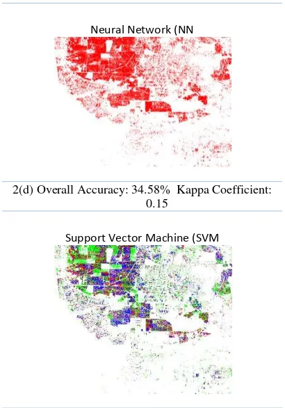
Neural Network (NN
2(d) Overall Accuracy: 34.58% Kappa Coefficient: 0.15
Support Vector Machine (SVM
2(e)Overall Accuracy: 54.18%Kappa Coefficient:0.39
PHASE I
PHASE II
of support vector machines as a promising machine learning methodology. It uses minimal training pixels, and therefore, needs less processing time. SVM is widely used in remote sensing field due to its ability to generalize well even with limited training samples. A study has carried out land cover classification by comparing the SVM with three other popular classifiers, maximum likelihood (ML) classifier, neural network (NN) classifiers and decision tree (DT) classifiers. This study also carried out several training data and proved that SVM and NN perform almost similar function[17].
NN is a non-parametric method which does not depend on the multivariate Gaussian distribution assumption. Knowledge is stored in weight form in neural network. The weights are applied to node as multiplicative values to be applied to an input. NN allows it to learn itself as it is presented with repeated examples of input and corresponding correct output. Upon presentation of new data to the net, NN applies weight, and the resulting output is consistent with the previous experience. Through various studies, NN often able to perform better than the ML. Some of the findings suggested that neural network is easy to be used for classification of study data; however, the more difficult study data might respond better in a hierarchical network.
March 1st 1984, and its main function to collect imagery of the surface of Earth. It has a maximum transmission bandwidth of 85 Mbit/s. It was used at an altitude of 438.5 mi (705.3 km). It takes 16 days to scan the entire Earth. Each remote sensing sensor has its own spectral resolution or the spectral sensitivity limitations. Landsat-5 TM consists of seven bands, where bands 1-5 and 7 record information at visible and near infrared wavelengths; therefore, it operates only in daytime. Night scenes can be captured in band 6 as it has the capability to record thermal infrared radiation. A TM scene has an Instantaneous Field of View (IFOV) that is capable of viewing image with 30m x 30m spatial resolution on the ground in bands 1-5 and 7 while 120m x 120m for band 6 (Table 1). The state of Selangor, Malaysia was chosen as the focus area of study as Selangor is a well
2.0
STUDY SITE AND EXPERIMENTAL DATA 7030/Landsat Index of peninsular Malaysia by ARSM Cartography Laboratory, the survey is at row 58 and path 27.3.0
MATERIALS AND METHODSThe Image processing tasks were performed using the ENVI software. ENVI toolbox was used to identify spectral values or a signature associated with the training pixels. This study
was divided into 2 phases: Phase I is the land cover classification, whereas phase II is the oil palm age classification. The study made use six of the Landsat TM bands (i.e. 1-5 and 7), where the bands with a combination of 4,3,2 have been used for visual analysis purposes. This band combination is useful for vegetation studies, monitoring drainage and soil patterns, and other various stages of crop growth. In phase I, the visual analysis of the Landsat data, aided by a land cover map, was carried out, where 10 main classes were identified that are the coastal swamp forest, dry land forest, oil palm, industry, cleared land, urban, non-oil palm, bare land, sediment plumes and water. Ten regions of interest (ROIs) based on the reference map were determined by choosing one or more polygons for each class based on visual analysis of the land cover map and Landsat data. Then, random samples were collected by means of stratified random sampling technique, which involves dividing the pixels into homogeneous subgroups (the ROI for individual classes), and then taking a simple random sample in each subgroup. 40% of the training pixels and 60% of the testing pixels were formed. The image was classified using a supervised ML technique that utilised the 40% training pixels, in which bands 1-5 and 7 were taken as the input. Accuracy assessment was then performed using a confusion matrix; the overall accuracy was calculated by summing the number of correctly classified pixels and dividing by the total number of ground truth pixels [16,22,24]. The classified image was then masked, subset and resized to extract only the oil palm region.
1550
ISSN 1013-5316; CODEN: SINTE 8 Sci.Int.(Lahore),26(4),1547-1551,2014insufficient number of training pixels chosen for the ML classifier. The ML depends very much on the sufficiency of the training set compared to SVM. NN produced the lowest accuracy, i.e. 34.58% overall accuracy and 0.15% kappa coefficient. The results indicate that the most important characteristic of SVM is its ability to generalize well from a limited amount and/or quality of training data [18]. The SVM offers additional benefits, in contrast to the alternative classification models, such as the neural networks. They are resilient to getting trapped in local minima because of the convexity of the cost function which enables the classifier to consistently identify the optimal solution. Besides,, the SVM also deals with quadratic problems; hence, it always gets to the global minimum. An added advantage is that it is unnecessary to repeat the classifier training using different random initializations or architectures. Furthermore, being non-parametric, the SVMs do not assume a known statistical distribution of the data to be classified. This is particularly useful because the data acquired from the remotely sensed imagery usually have unknown distributions. This allows the SVM to outperform other techniques based on maximum likelihood classification because the normality does not always give a correct assumption of the actual pixels NN allows to learn by itself as it is presented with repeated examples of input and corresponding correct output, it tends to get confused with the large number of training pixels; thus, leading to incorrect classifications of the the region. Based on a study by Hepner, he considered a training data size of a 10 by 10 pixels for each class as the minimum data size for training the NN [19]. The minimum number of samples for adequately training an algorithm may depend on the algorithm concerned, the number of input variables, the method used to select the training samples, and the size and spatial variability of the study area [20]. Overall, the SVM is the best oil palm age classifier among the compared classifiers as it records the highest accuracy with 188 out of 347 pixels correctly classified. To be more specific, the SVM records accuracy of more than 50% of correctly classified pixels for class young, old and unclassified when compared to the ML and NN. Even though the SVM classification produced the highest accuracy; there are some limitations to SVM methodologies, for example the selection of the SVM’s key parameters, such as the kernel functions. Further studies on kernel functions of the SVM should also be conducted for better performance. Table 2 shows the number of pixels and area covered using the SVM classifier.
5.0
CONCLUSIONThis study evaluates the potential of remote sensing techniques in classifying the age of oil palm tree. Three types of classification used in the study are the ML, NN and SVM. The ML can classify different land covers with the
highest accuracy, but the SVM is found to be the most reliable for classifying the age of the oil palm trees as compared to the ML and the NN. Further studies should consider different number of training pixels in order to observe better comparisons between the SVM, ML and NN.
ACKNOWLEDGEMENTS
We would like to thank Universiti Teknikal Malaysia Melaka (UTeM) for funding this project under the UTeM Short Term Grant (PJP/2013/FTMK(2B)/S01104). Our appreciation also goes to the Malaysian Remote Sensing Agency (ARSM), Klang Municipal Council, Eng Soon Plantation coordinator, Mr. Perumal and others who directly or indirectly helped in providing the information required for this study.
REFERENCES
[1] L.P. Koh and D.S. Wilcove, “Cashing in palm oil for conservation,”Nature vol. 448, pp. 993–994, 2007. [2] E.B. Fitzherbert et al.,”How will oil palm expansion
affect biodiversity ?,” Trends in Ecology & Evolution, vol. 23(10), pp.1–8, 2008.
[3] K.P. Tan, K.D. Kanniah, and A.P. Cracknell, “Use of UK-DMC 2 and ALOS PALSAR for studying the age of oil palm trees in southern peninsular Malaysia,”International Journal of Remote Sensing, vol. 34(20), pp.1–15, 2013.
[4] J. W. Van Gelder, “Greasy Palms: European buyers of Indonesia palm oil,”Friends of the Earth, 2004, Available online at:
http://www.foe.co.uk/resource/reports/greasy_palms_b
uyers.pdf.
[5] Syahrinudin, “The potential of oil palm and forest plantations for carbon sequestration on degraded land in Indonesia," Ecology and Development, 2005, Palm Research, vol. 11(1), pp.23-32, 1999.
[8] S. F. Foong, “An improved weather based model for estimating oil palm fruit yield,” International Conference on Oil Palm in Agriculture in the Eighties. Session-Prediction, Prospect and Forecast, pp. 327-349, 17-20 Jun 1981, Kuala Lumpur
[9] J. McMorrow, “Linear regression modelling for the estimation of oil palms age from Landsat TM,”International Journal of Remote Sensing, vol. 22(12), pp. 2243-2264, 2001.
[10] H. Buddenbaum, M. Schlerf and J. Hill, “Classification of coniferous tree species and age classes using hyperspectral data and geostatistical methods,” International Journal of Remote Sensing, vol. 26, pp. 5453–5465, 2005.
classification and regression trees approaches to hyperspectral data,” International Journal of Remote Sensing, vol. 29, pp. 1841-1845, 2008
[12] H. Sirén and E.S. Brondizio, “Detecting subtle land use change in tropical forests,” Applied Geography, vol. 29(2), pp. 201-211, 2009.
[13] S.E. Franklin, R.J. Hall, L. Smith, L and G.R. Gerylo, “Discrimination of conifer height, age and crown closure classes using Landsat-5 TM imagery in the Canadian Northwest Territories,” International Journal of Remote Sensing, vol. 24, pp. 1823-1834, 2003. [14] W.B. Cohen, W. B., Spies, T. A., And Fiorella, M.,
1995, Estimating the Age and Structure of Forests in a Multi-Ownership Landscape of Western Oregon, USA. International Journal of Remote Sensing, 16, pp. 721-746.
[15] W.A. Salas, and D.L. Skole, “Mapping secondary tropical forest and forest age from SPOT HRV,” International Journal of Remote Sensing”, vol. 20(18), pp.3625–3640, 1999.
[16] O. Skoupý, L. Zejdová and J. Hanuš “The use of hyperspectral remote sensing for mapping the age composition of forest stands,” Journal of Forest Science, vol. 57(6), pp.287–297, 2011.
[17] A. Ahmad, “Analysis of Maximum Likelihood Classification on Multispectral Data,” Applied Mathematical Sciences, vol. 6(129), pp. 6425-6436, 2012.
[18] L.S. Davis, “An assessment of support vector machines for land cover classification,” International Journal on Remote Sensing, vol. 23(4), pp.725–749, 2002.
[19] G. Mountrakis, J. Im and C. Ogole, “Support vector machines in remote sensing: A review,”ISPRS Journal of Photogrammetry and Remote Sensing, vol. 66(3), pp.247–259, 2002.
[20] G.F. Hepner, T. Logan, N. Ritter and N. Bryant, “Artificial neural network classication using a minimal training set: comparison to conventional supervised classication,” Photogrammetric Engineering and Remote Sensing, 56, 496–473, 1990.
[21] X. Zhuang, B.A. Engel, D.F. Lozano-Garcia, R.N. Fernandez and C.J. Johannsen, “Optimization of training data required for neuro-classification,” International Journal of Remote Sensing, 15(16), 3271–3277, 1994.
[22] A. Ahmad, “Analysis of Maximum Likelihood Classification Technique on Landsat 5 TM Satellite Data of Tropical Land Covers,” Proceedings of 2012 IEEE International Conference on Control System, Computing and Engineering (ICCSCE2012). pp. 1-6, 2012.
[23] N. I. S. Bahari, A. Ahmad and B. M. Aboobaider, “Application of support vector machine for classification of multispectral data,” 7th IGRSM International Remote Sensing & GIS Conference and Exhibition. IOP Conf. Series: Earth and Environmental Science 20, 2013.
[24] A. Ahmad and S. Quegan, “Comparative Analysis of Supervised and Unsupervised Classification on Multispectral Data,” Applied Mathematical Sciences, vol. 7(74), pp. 3681-3694, 2013