Dept. of Information System, Universitas Diponegoro, JL Imam Barjo, Semarang, Indonesia 2
Dept. of Physic, Universitas Diponegoro, JL Prof Sudharto SH, Semarang, Indonesia 3
Dept of Mechanical Engineering, Universitas Diponegoro, JL Prof Sudharto SH, Semarang, Indonesia *Corresponding author, E-mail: [email protected], [email protected], [email protected]
Abstract
Particle filter been used for localization and position estimation with various applications. Several method applied in order to reduce the complexity of particle information to lower processing resource requirement while providing a precise map. Sonar sensor provide a range precision with poor bearing. Partial observation applied to gain estimation of object location using several measurement from multiple vantage point. This paper propose grouping of detection particle from sonar sensor using clustering method in order to provide estimated object position from a single vantage point. The approach estimate objects using euclidean distance treshold to separate one object detections from the other and group all the detection particle into cluster containing a set of number. As a result of particle clustering, object location can be estimated with their respective weight of certainty as an attribution for further decision making.
Keywords: sonar, particle filter, clustering, slam
1. Introduction
Simultaneous localization and mapping (SLAM) has been widely developed and implemented using several method and approach. SLAM main purpose is to compose an environment map using a mobile robot while estimating it's location on the map simultaneously. Ref [1] state that SLAM problems is successfully solved over last decade using various available approaches and methods.
The essential of SLAM methods use estimation and probability to solve its problem [1]. Statistic calculation used to analyze large amount of data gathered by SLAM system. The SLAM data consist of object and environment detection from robotic sensors and movement data from robotic actuators feedback. Particle filter approach used to manage uncertainty in SLAM data to estimate the robot and objects location on the map. Ref [2] compare various approach of location estimation based on bayesian filters.
2. Sensor Characteristic
SLAM method result highly related with the sensors accuracy and detection modeling [3]. Different sensors produce different output according to its characteristic and measurement method. Surface roughness of material detected also interfere the data acquired [4]. Sensor measurement often uses time of flight method. Equation (1) shows that distance traveled between sensor to object and back to sensor in d is the speed of signal in c times the flight duration in t.
d = c.t (1)
Figure 1. Sonar sensor sensitivity pattern
Laser ranging had the most accurate measurement and also the fastest sensor available in market [3]. Typical laser ranging sensor does detection up to 200m with 0.10 resolutions [3]. Disadvantages of using laser ranging are that it is expensive and spent high energy consumption [3]. Laser ranging sensor also had problems with reflecting surface such as mirrors, windows etc [3].
Visual sensor like camera provides a better bearing with poor range [5]. The visual SLAM method locate feature from image captured by the camera as reference for localization and further mapping. Ref [7] describes the application of active vision approach within SLAM systems. Visual approach in SLAM require easily distinguished landmark from their environment [7]. Using available object as landmark generate more object detected and more computation complexity required.
Sensor used in this research is HC-SR04 low cost sonar sensor working on 40 kHz frequency with effective measurement up to 8inch [8]. The servo mounted on top of hxt900 micro servo that provides 1800 rotation for observation purpose. Sensor mounted on robotic chassis shown on Figure 2.
Figure 2. Sonar sensor mounted on servo
3. Object Localization Approaches
[image:2.595.189.406.478.641.2]Figure 3. Partial observation (a) range-only (b) baring only
Figure 3 display partial observations which use range only sensor and bearing only sensor [5]. As the robot move, more object detection with more vantage points acquired, resulting a more accurate estimation of object location. Partial observation method requires detection data from at least two vantage points. All the information from every detection vantage point carried along the delayed mapping progress to estimate object location. The large sets of data carried increase computing complexity and spent more resource and energy.
3.1 Particle Clustering
Clustering been introduced as mass dataset grouping method. Ref [11] describes clustering method as an examination process towards collections of data sets and groups them into several clusters with certain similarities between its members. Ref [12] applies clustering for effective and efficient data mining approach based on random search by analyzing spatial distribution.
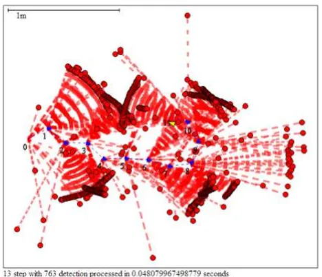
[image:3.595.182.416.521.722.2]Rotating sonar sensor generates huge sets of data that are the rotation angle over the resolution. In this research, 1800 degrees data with 10 resolutions generate up to 180 particles for each step. Some angle might return no value because there is no object detected. Ref [13] describe about building a simple SVG map to represent spatial information as a result of non destructive observation of robotic system. Figure 4 display a sample map containing spatial distribution of sonar sensor detection particle.
The number of particle in the cluster represent certainty of the location that increased along with additional measurement data especially from different vantage point. To preserve cluster complexity, particle data can be stored with their respective cluster membership relation for further analysis such as determining object shape, planning obstacle avoidance save path, etc.
Figure 5. Clustering process flow
3.2 Clustering Result
The estimated object location after particle clustering plotted into two dimensional maps with exact same scale and center point to compare with the particle distribution before clustering. As an example, particle clustering with threshold 10cm and no minimum certainty weight displayed in Figure 6.
Figure 6. Sonar detection after clustering
(a) (b)
Figure 7. Sonar experiment data using different parameter (a) 20cm threshold and no minimum weight. (b) 10cm threshold and minimum weight 10.
[image:5.595.101.498.274.444.2](a) (b)
Figure 8. Different data also shows less noisy map (a) before clustering (b) after clustering
[image:5.595.100.497.495.677.2]view of the map displaying less data and more information.
The higher value in threshold and certainty weight, the less cluster generated lowering further computation complexity but may resulting multiple object recognized as one.
Further research can be applied using several sensor like laser, imaging and inertial measurement unit.
References
[1] Durrant-Whyte H, Bailey T. Simultaneous Localization and Mapping (SLAM) Part I. IEEE Robotics & Automation Magazine. 2006; 13(2): 99-108.
[2] Fox D, Hightower J, Liao L, Schulz D, Borriello G. Bayesian Filters for Location Estimation. IEEE Pervasive Computing. 2003; 24-33.
[3] Ruckert EA. Simultaneous Localisation and Mapping for Mobile Robot with Recent Sensor Technologies. Master Thesis. Graz: Graz University of Technology; 2009.
[4] Suryono, Kusminarto, Suparta GB. Estimation of Solid Material Surface Roughness using Time-of-Flight Ultrasound Immerse Transducer. Journal of Materials Science and Engineering. 2010; 4(8): 35-39.
[5] Bailey T, Durrant-Whyte H. Simultaneous Localization and Mapping (SLAM) Part II. IEEE Robotics & Automation Magazine. 2006; 13(3): 108-117.
[6] Saleem MM. An Economic Simultaneous Localization and Mapping System for Remote Mobile Robot Using SONAR and an Innovative AI Algorithm. International Journal of Future Computer and Communication. 2013; 2(2): 147-150.
[7] Davidson AJ, Murray DW. Simultaeous Localization and Map-Building using Active Vision. IEEE Transaction on Pattern Analysis and Machine Intelligence. 2002; 24(7): 865-880.
[8] Product User's Manual - HC-SR04 Ultrasonic Sensor, Cytron Technologies, 2013.
[9] Leonard JJ, Rikoski RJ, Rus D, Singh S, Editors. Incorporation of delayed decision making into stochastic mapping, Experimental Robotics VII. New York: Springler Verlag, 2001.
[10] Tardos JD, Neira J, Newman PM, Leonard JJ. Robust Mapping and Localization in Indoor Environments Using Sonar Data. The International Journal of Robotic Research. 2002; 21(4): 311-330.
[11] Rajaraman A, Ullman JD, Leskovec J, Editors. Mining of Massive Datasets. Cambridge: Cambriddge University Press, 2011.
[12] Ng RT, Han J. Efficient and Effective Clustering Methods for Spatial Data Mining. Proceeding of the 20th VLDB Conference. 1994: 144-155.
[13] Pradhana HW, Suryono, Widodo A. Visualization of Simultaneous Localization and Mapping using SVG : Non Destructive Observations and Visualization of Robotic System. Proceeding of the 2nd International Conference on Information Systems for Business Competitiveness (ICISBC). 2013: 134-138.