Satellite Imagery and In-situ Data Overlay Approach
for Fishery Zonation
Khairul Munadi, Fardhi Adria
Department of Electrical Engineering, Faculty of Engineering, Syiah Kuala University Jl. Syech Abdurrauf No.7, Darussalam, Banda Aceh, 23111, Phone/Fax: 0651-7554336
e-mail: [email protected], [email protected]
Abstrak
Teknologi penginderaan jauh dapat digunakan untuk lebih memahami karakteristik bumi. SeaWiFS (sea-viewing wide field-of-view sensor) adalah salah satu sensor penginderaan jauh yang berfungsi khusus untuk mengamati fenomena lautan. Beberapa studi menunjukkan bahwa profil sebaran klorofil-a merupakan salah satu indikator keberadaan ikan di laut. Namun, masih sangat sedikit penelitian yang mencoba menentukan hubungan antara informasi sebaran klorofil tersebut yang diperoleh lewat interpretasi citra satelit dengan data in-situ sebaran ikan. Pada makalah ini akan disajikan hasil penelitian yang merelasikan data hasil interpretasi citra sebaran klorofil-a dengan data titik lokasi tangkapan ikan di perairan laut Provinsi Aceh, menggunakan pendekatan analisa citra overlay. Hasilnya lalu dipakai untuk mengidentifikasi zonasi daerah potensi tangkapan ikan di Aceh. Profil sebaran konsentrasi klorofil-a diperoleh dari interpretasi citra satelit SeaWIFS dan data titik lokasi tangkapan ikan diperoleh dari komunitas nelayan Lembaga Panglima Laot Lampulo, Banda Aceh mulai bulan Juni hingga November 2008. Hasil penelitian menunjukkan bahwa profil konsentrasi klorofil-a dari citra satelit memiliki hubungan yang positif dengan titik lokasi tangkapan ikan. Zona tangkapan ikan paling potensial di perairan laut Aceh terletak pada rentang 5–8o LU dan 96–99o BT.
Kata kunci: citra satelit, citra overlay, inderaja, klorofil-a, SeaWIFS
Abstract
Remote sensing technology is useful to give a better understanding about the earth’s characteristics. SeaWiFS (sea-viewing wide field-of-view sensor) is one of remote sensors used to observe global ocean phenomena. Previous studies showed that the distribution of chlorophyll-a in the ocean indicates the presence of fish. However, only a few studies tried to directly relate the chlorophyll-a distribution obtained through interpretation of satellite imagery to in-situ data of fish distribution. This paper investigates the relation between chlorophyll-a distribution and fish-capturing points in Aceh Province sea waters using overlay image analysis. The results are useful to identify the potential fishing ground in Aceh. The profile of chlorophyll-a concentration was derived from SeaWIFS satellite imagery and fish-capturing points data was obtained from the fisherman communities of Banda Aceh, starting from June to November 2008. The results show that the chlorophyll-a profile derived from satellite imagery has a positive relationship to fish-capturing point data. The most potential fish-capturing zone in Aceh sea waters is identified at 5-8º north latitude (N) and 96-99º east longitude (E).
Keywords: chlorophyll-a, image interpretation, overlay image, remote sensing, SeaWiFS
1. Introduction
Remote sensing technology has been developing very fast. It began with Landsat Satellite Multi Spectral Scanner (MSS), which was launched in 1972 and which provides earth imagery at a high resolution. The use of satellite imagery is then increasingly used to explore the characteristics and potential of the planet Earth [1].
ocean, phytoplankton becomes life support for fisheries because it is a primary producer. Chlorophyll-a concentration in the ocean signifies the presence of phytoplankton and indicates the potential presence of fish within that area [2-8].
Several studies have been done that are relevant to the utilization of satellite remote sensing imagery for profiling the distribution of chlorophyll-a in the Indonesia ocean [4-8]. However, there are very little attempts to compare the distribution of the chlorophyll-a profile with in-situ data of fish catches, except for what has been done by HR Girsang [8]. In his research, Girsang [8] utilized the MODIS (moderate resolution imaging spectroradiometer) sensor for detecting chlorophyll-a distribution in Pelabuhanratu, West Java, and correlated it with a tuna catch area. Unfortunately, approach and research stages conducted were not clearly described.
In this paper, chlorophyll-a distribution data will be compared with fish catch data points to determine the relationship of both variables using an overlay image approach and analysis. However, chlorophyll-a profile imagery was obtained from satellite image interpretation by using different sensors, namely SeaWIFS, which is specifically used for observing oceanographic parameters. In addition, potential areas of fish catches were limited to sea waters in the Aceh Province region. In the context of Indonesia, which has a very broad area of marine waters, research with the same goal, but for a different area of coverage, is important to validate the relationship between chlorophyll-a concentration and a fish-catch point distribution? The results can be used for estimating fish-catch zoning in the waters of Indonesian archipelago, therefore.
2. Research Method
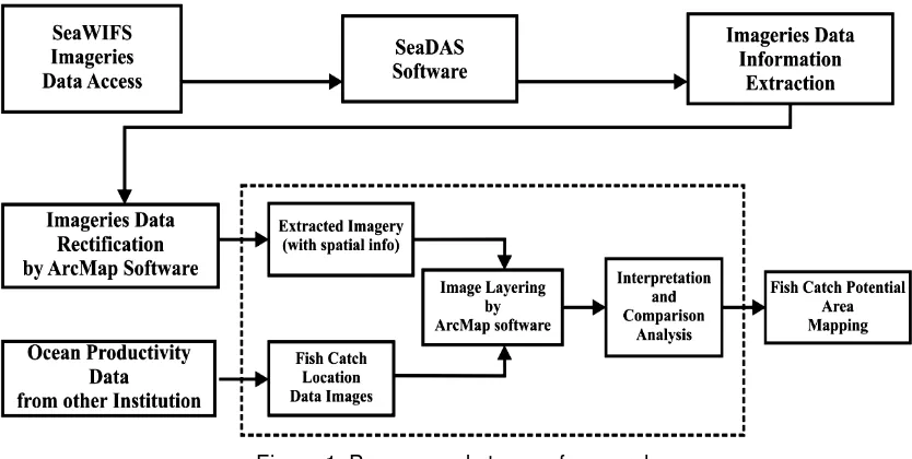
Figure 1 illustrates the overall process performed in this research, which is data from SeaWIFS satellite imagery interpretation overlayed or layered with in-situ data (field data) points of fish-catch locations. In-situ data was obtained from the fishing communities of Panglima Laot, Lampulo, Banda Aceh. The communities recorded data through a number of fish finders that were available on their fishing boats. The coverage area of this research is marine waters of the Aceh province in the range of 2-8o N and 92–99o E, which is the economic exclusive zone (EEZ) of Aceh Province. Because of limited in-situ data as comparable data, the time span of data analyzed in this research is limited to June to November 2008.
Figure 1. Process and stages of research
2.1 SeaWIFS Imagery Data Obtaining
SeaWIFS image data is downloaded from the NASA (National Aeronatics and Space Administration) at this URL: http://oceancolor.gsfc.nasa.gov, with user’s research purposes verification. Image data is distributed on several levels of data according to user needs.
Daily image data have a tendency to cloud and make it difficult to analyze chlorophyll-a distribution in ocean waters of Aceh Province. However, monthly Level-3 image data from accumulated Level-2 image data are quite possible to present the variation of chlorophyll-a concentration in marine waters of Aceh Province.
2.2 SeaWIFS Imagery Data Processing
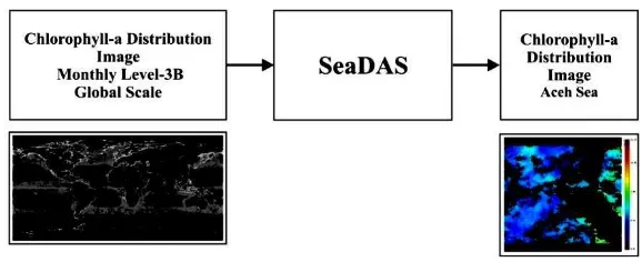
Level-3 Binned global representation monthly accumulated imagery obtained are processed by software SeaDAS (SeaWIFS Data Analysis System). The process is shown in Figure 2, and the results are :
1. Chlorophyll-a distribution image of sea waters of Aceh, which is in range of coordinates 2-8o N and 92–99o E.
2. ASCII data distribution of chlorophyll-a sea waters of Aceh, which is a tabulation of data values of chlorophyll-a concentration for each pixel and the coordinates.
Figure 2. Imagery data extraction
2.2 Chlorophyll-a Imagery Data Rectification
Extracted image data results from SeaDAS does not have spatial information, so a rectification process is needed. Rectification is the process of providing spatial information by adding coordinated information of the earth on the target image. Rectification will allow the process of layering or overwriting the layer between the chlorophyll-a distribution image and the fish-catch location image data that has spatial information. Rectifying the image of the distribution of chlorophyll-a in this study was conducted with ArcMap software, as shown by Figure 3.
Figure 3. Imagery data rectification
2.3 Data Analysis and Interpretation
the consideration that the concentration of chlorophyll-a above 0.2 mg/m3 has shown the presence of phytoplankton life sufficient to sustain the proliferation of fish [8], [9], [10].
Table 1. Chlorophyll-a related to productivity of fish
Chlorophyll-a Concentration
(mg/m3) Assessment
0,0 – 0,1 Slightly
0,1 – 0,2 Sufficient
0,2 – 0,6 Excessively
3. Results and Discussion
In this section, the results and analysis will be presented and discussed, including a chlorophyll-a distribution profile for Aceh sea waters, potential fish-catch locations, and the overlay of chlorophyll-a distribution with the fish-catch location data. Data used in this study are the distribution of chlorophyll-a obtained from SeaWIFS imagery, ranging from June to November 2008. For other months, in-situ data capture point locations are not available and cloud cover also dominates some SeaWIFS imagery, so that comparisons could not be done.
3.1 Chlorophyll-a Distribution
In Figures 4 and 5, the examples of chlorophyll-a monthly composite distribution images for June and November 2008, obtained from SeaWIFS satellite image interpretation are shown. The color code in the top-right image shows the intensity level of chlorophyll-a, beginning with lowest (black) to the highest (red).
Figure 4. Chlorophyll-a distribution imagery, June 2008.
Figure 5. Chlorophyll-a distribution imagery, November 2008.
In general, mean value of chlorophyll-a concentration in the range from June to November 2008 varied from 0.000 to 3.456 mg/m3, with the highest concentration of 17.277 mg/m3 being in October.
3.2 Data Analysis
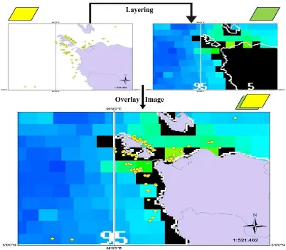
Figure 6, where the layer of fish-catch location data falls on the layer of chlorophyll-a distribution in October 2008.
Figure 6. Layering process of both data on October 2008.
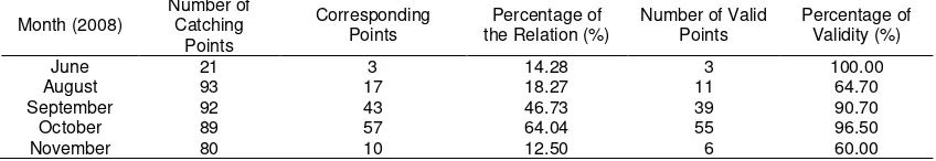
Results of overlay analysis between fish-capture points and chlorophyll-a distribution at sea waters of Aceh in June, August, September, October, and November of 2008 are summarized in Table 3. Descriptions for the naming of each column in Table 3 are:
• Month indicates the period in 2008.
• Number of catching points represents the total number of points-catchment locations on related time. This data shows the location of the fish obtained by in-situ.
• The number of corresponding points is the number of fish-catch point locations that have a value for chlorophyll-a concentration. Several catch-point locations do not have the concentration of chlorophyll-a data because the points were covered by cloud at the time the sensor SeaWIFS crossed.
• Percentage of the relation shows a comparison of the number of capture points that have a value of chlorophyll-a with a total point of capture.
• The number of valid points indicates the number of capture points that have a concentration of chlorophyll-a values above 0.2 mg/m3, which indicates a life of phytoplankton in adequate number and is assumed to be an indication of fish presence.
•
The percentage of validity is taken from the comparison between the numbers of valid points to the corresponding number of points.Layering
Table 2. Samples of SeaWIFS satellite data and in-situ fishery points, October 2008
Table 3. Relationships of chlorophyll-a distribution with the points of fish-catch
Month (2008) September and October because land conditions when data are obtained is almost free of cloud cover. Thus, imagery interpretation to determine the chlorophyll-a distribution profile in territorial sea-waters of Aceh province is not difficult to do. The data of fish-catch location points and chlorophyll-a distribution during the period from June to November 2008 showed a consistency match between the presence of fish with concentrations of chlorophyll-a that are high (above 0.2 mg/m3); the validity ranges from 60-100%. Hence, iIt can be used as initial information in determining potential fish-catch locations.
There are also some fish capture points that do not have compatibility with chlorophyll-a concentration value at that point, however. This can be caused by several factors, such as:
• Part of chlorophyll-a distribution data captured by SeaWIFS sensor is the result of sediment coming down from the mainland, which mostly happens in coastal areas and estuaries [11].
• Data obtained from satellite images contain a lot of cloud cover, so the profile of chlorophyll-a in chlorophyll-a pchlorophyll-articulchlorophyll-ar plchlorophyll-ace is not chlorophyll-avchlorophyll-ailchlorophyll-able.
• There is a shift in the location of the point of capture in the process of layering. This could be due to inadequate image resolution of SeaWIFS.
• The distribution of fish is not only influenced by the concentration of chlorophyll-a, but also likely by other factors such as ocean currents and temperatures.
3.3 Zonation of Potential Fishery Area
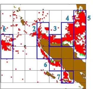
Potential fish-catch zoning will be extremely beneficial for fishing communities as initial information in determining the catchment area. Considering the results of overlay analysis above, the zonation of potential fish catchment can be made based on chlorophyll-a distribution profiles obtained from SeaWIFS sensor. Figure 7 illustrates the model of zoning for October 2008 that is based on a chlorophyll-a distribution profile for the corresponding month. Potential catchment areas were given a red color, namely:
4. Conclusion
This paper have presented results from our work utilizing overlay images of SeaWIFS satellite and in-situ data to determine the relationship between chlorophyll-a distribution and fish capturing points in sea waters of Aceh Province. We discovered a considerable consistency match between the presence of fish with high concentrations of chlorophyll-a in the region. Therefore, chlorophyll-a distribution imagery obtained from SeaWIFS remote sensing satellite can be used as one source of information in determining potential fishing zones in Aceh Province. Profile of chlorophyll-a distribution imagery during the months of September, October and November 2008 showed that the most potential fishing zone in Aceh sea waters lies within the range 5-8o N and 96-99o E.
As a future direction, the higher variability and validity of this research would take a longer duration of time and additional in-situ data locations for comparison is noted. Relevant parties are encouraged to attempt to obtain such data. Furthermore, the diversity of chlorophyll-a concentrchlorophyll-ation is one indicchlorophyll-ator to predict the presence of fish. Obtchlorophyll-aining better prediction results could take other variables, such as surface temperature and ocean currents.
References
[1] Lillesand T, Kiefer RW, Chipman J. Remote Sensing and Image Interpretation. Sixth Edition. New York: John Wiley & Sons. 2007.
[2] Hydea KJW, O’Reillya JE, Oviattb CA. Validation of SeaWiFS Chlorophyll-a in Massachusetts Bay. Continental Shelf Research. 2007; 27(12): 1677-1691.
[3] Mansor S, Tan CK, Ibrahim HM, Shariff ARM. Satellite Fish Forecasting in South China Sea. Proceeding of The 22nd Asian Conference on Remote Sensing (ACRS). Singapore. 2001: OCN-07.
[4] Siswantoro Y, Arsjad ABSM, Dewi RS. Inventarisasi SDA dan Lingkungan Hidup: Sebaran Chlorophyll–a di Perairan Indonesia Skala 1:1.000.000. Jakarta: Pusat Survei Sumberdaya Alam Laut BAKOSURTANAL. 2004.
[5] Basith A, Hendiarti A, Syohraeni. Mapping Chlorophyll-a of Southern Java Waters using SeaWIFS and MODIS Aqua. Proceeding of Map Asia. Jakarta. 2005: 101-105.
[6] Tan CK, Ishizaka J, Manda A, Siswanto E, Trypathy SC. Assessing Post-tsunami Effects on Ocean Colour at Eastern Indian Ocean using MODIS Aqua Satellite. International Journal of Remote Sensing. 2007; 28(13-14): 3055-3069.
[7] Aini MQ. Kajian Distribusi Potensi Fitoplankton Di Sebagian Laut Utara Jawa Menggunakan Citra Modis. ProsidingSemnaskan UGM. Yogyakarta. 2008: 74-81.
[8] Girsang HS. Studi Penentuan Daerah Penangkapan Ikan Tongkol Melalui Pemetaan Penyebaran Klorofil-a dan Hasil Tangkapan Di Palabuhanratu, Jawa Barat. Thesis. Bogor: Institut Pertanian Bogor; 2008.
[9] Apel JR, Gower JFR. Opportunities and Problems in Satellite Measurements of the Sea. UNESCO Technical Papers in Marine Science. 1986; 1-120.
[10] Widodo J. Aplikasi Teknologi Penginderaan Jauh untuk Perikanan di Indonesia. Jakarta: Badan Pengkajian dan Penerapan Teknologi. 1999.