Liu Hui*, Wu Jianjiang, Li Ling, Li Zhizhe
Department of Electrical and Information Engineering, Beijing University of Civil Engineering and Architecture, Beijing, 100044, China
*Corresponding author, e-mail: [email protected]
Abstract
Tomographic Synthetic Aperture Radar extends the traditional 2D SAR imaging to multi dimension imaging by reconstructing the real scene of SAR sensor on the ground. It is very important to realize the 3D mapping of urban areas, the identification of artificial targets and so on. The mathematical model of Tomographic SAR Imaging is deduced and its significance in physics are introduced herein, then the resolution ability in nsr direction is analyzed. At last, the applications of tomographic SAR imaging technology are prospected.
Keywords: Tomographic SAR; SAR three-dimensional imaging; Tomographic SAR imaging algorithm
1. Introduction
Tomographic Synthetic Aperture Radar Imaging Technology (Tomographic Synthetic Aperture Radar, referred to as TomoSAR or SAR Tomography) is remote sensing means which extends theory of imaging technology of two-dimension in tradition to height dimension, gaining ground three-dimensional information. Different from Interferometric SAR, Tomographic SAR Three-dimensional Imaging Technology adopts the idea of height dimension synthetic aperture to solve problem of several base lines interference, realizing resolution capability of height dimension [1, 2]. In the early of 90s of last century, Tomographic Technology has been brought in SAR field. But image data which can be used for research was rare. With levitation of a new generation high resolution satellite in succession after 2007, a large number of high-quality SAR tomographic image was provided Error! Reference source not found.. Density of scatterer with
high resolution data increased rapidly, and signal to noise ratio improved sharply. Compared with original medium resolution ratio data, it is more suitable to carry out SAR tomographic research. Tomographic SAR Imaging Technology provides above rubies technical support in terms of fine application of topographic surveys of high precision, accurate assessment of disasters, dynamic monitoring of topography, three-dimensional reconstruction of urban region etc. Several base lines SAR Tomographic Imaging Technology becomes research direction which is relatively hot in present SAR field.
2. Theoretical Analysis to Tomographic SAR Model
2.1. Mathematic Model and Physical Significance of Tomographic SAR
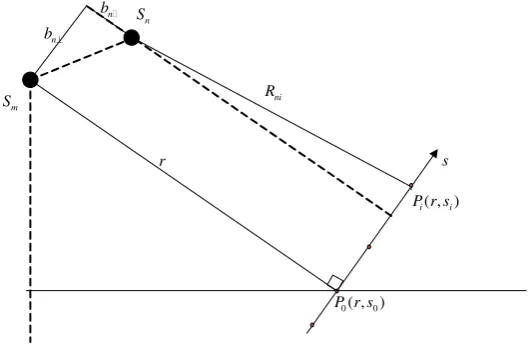
Figure 1. Geometric model of tomographic SAR Error! Reference source not found.
( , )
i i
P r s r
n b
n b
ni R n
S
m S
0( , 0)
P r s
s
Figure 2. Analysis graphics about tomographic SAR principle
As shown in Figure 2, supposing
S
m as main satellite, image gained asg
m, andg
n assynthetic aperture radar image gained by satellite
S
n, then0
4
exp(
)
K
n i ni
i
g
j
R
(1)In the formula (1),
i(i
0,1,
,
K
) is rear scattering coefficient of scattering pointP
i(
i
0,1,
,
K
)in Normal-Slant Range of S direction.R
ni(i
0,1,
,
K
) is distance of scattering pointP
i(i
0,1,
,
K
) in Normal-Slant Range of S direction to satelliteS
n.
is wave length of radar.K
is number of scattering point in Normal-Slant Range of S direction. According to geometrical relationship in Figure 2, it is2 2
(
)
(
)
ni n i n
[image:2.595.166.432.303.478.2]According to geometrical relationship in Figure 2 and taylor expansion of function, formula (2) is approximate to 2 ( ) ( ) 2( ) i n ni n n s b
R r b
r b
i
0,1,
,
K
(3)For
r
b
n , formula (3) can be written as2 ( ) 2 i n ni s b R r r
i
0,1,
,
K
(4)Supposing that formula (1) is multiplied by plural factor
exp(
4
R
n0)
, and0
4
exp(
)
n n n
G
g
R
, then it is0 0
4
exp[
(
)]
K
n i ni n
i
G
j
R
R
(5)Where,
R
n0 is slant-range of reference pointP
0 in Normal-Slant Range of S direction to satelliteS
n. Supposing that coordinate value of reference pointP
0 in Normal-Slant Range of S direction iss
0
0
, then it is2 0
2
n nb
R
r
r
(6)Further we can get
2
0
2
n i
ni n i
b s
R R s
r r
i
0,1,
,
K
(7)So, formula (5) can be changed to
2
0
2
0
4
exp[
(
)]
2
2
2
=
exp(
) exp( 2
)
K
n i
n i i
i K i n i i i
b
s
G
j
s
r
r
s
b
j
j
s
r
r
(8) Supposing 22
( )
exp(
i)
i i
s
s
j
r
, and define it as repeated backscattering0
2
( ) exp( 2 )
K
n
n i i
i
b
G s j s
r
(9)Supposing 2 n n
b f
r
, then formula (9) is
DFT[ ( )]
n
n i f f
G
s (10)In formula (10),
DFT[ ]
is discrete Fourier transform operation. So, above derivation process shows thatG
n is result of discrete Fourier transform of repeated backscatteringcoefficient of Normal-Slant Range target in frequency
f
n. We know that different position of satellite corresponds to different vertical base lines. Coming here, we can get the conclusion that satellite position which is distributed on base lines has something to do with frequency domain distribution of Normal-Slant Range target scattering point. Corresponding frequency is relevant with base lines. If it is written in the form of continuous signal, it is( ) exp( 2 )
n n
G
s j f s ds (11)n
G
represents that frequency component is image off
n. When image registration of enough images with different frequency component is finished, its sequence can be seen as Fourier transform of distribution function
( )
s
of scattering coefficient of Normal-Slant Range target. For Fourier inverse transform, information of distribution function
( )
s
of scattering coefficient of Normal-Slant Range target can be gained immediately.2.2. Resolution Capability Analysis on Tomographic SAR in Normal-Slant Range Error! Reference source not found.
When vertical base lines are sampled uniformly and sample interval is
b
, then2 b
f r
(12)
According to theorem of Nyquist, when sample interval of frequency domain is
f
,time domain range which can be reconstructed without fuzziness is
2
t
1
f
. Applied to above process, reconstructed range2
s
max (without fuzziness and with Normal-Slant Range) ismax
2
2
r s
b
(13)
max max
[
s
,
s
]
is span of Normal-Slant Range. Its equivalent synthetic aperture length in Normal-Slant Range depends on spanB
of vertical base lines. So image sequence can be specifically written asmax
max
( ) exp( 2 )
s
n n
s
G
s j
f s ds
(14)many research findings Error! Reference source not found. have been gained in elevation reconstruction of urban architecture, height of man-made target and extraction of shape change parameter, early warning in urban s
3.1. Reconstruction of Urban Building Elevation
Data set used in Tomographic SAR is all from same side of target. So Tomographic SAR can be carried out only in part elevation of building, i.e. building elevation shined by SAR. With stored quantity of SAR data becoming richer and richer, Tomographic SAR data set in different angles of the same area is richer and richer, bringing opportunity to three-dimensional reconstruction of total building elevation. Condition near urban architecture is complex, so adopting means of SAR to realize reconstruction is a challenging research. Appearance of Tomographic SAR makes effectiveness of application of microwave remote sensing means improved to a higher level. Previously, workers engaged in SAR technology research carried out many researches that adopted SAR images in aspect of urban building. One kind of method is to detect and extract building Error! Reference source not found. from single SAR image Error! Reference source not found. or by using Interferometric SAR. But these methods failed to realize
reconstruction of height dimension. They are all SAR images shined from same side of building and it is impossible to gain elevation not shined in building. Technology of research on building reconstruction by adopting several angles InSAR Error! Reference source not found. was put
forward, but complex urban scene and existence of speckle effect and layover effect which was immanent in SAR image made above researches limited to building reconstruction in a certain extent.
With acquisition of data of high resolution satellite borne SAR and appearance of Duohangguo In SAR technology, permanent scatterer InSAR technology and even TomoSAR technology, accurate three-dimensional reconstruction can be realized aimed at individual building in complicated background. Up to now, Zhu Xiaoxiang and Shahzad have carried out fruitful research [12, 13] in this aspect, and Zhu Xiaoxiang etc. have used multi-angles Tomographic SAR to gain building elevation point cloud of Hotel Bellagio in Las Vegas in America.
3.2. Running Parameter Extraction of Objects on the Ground
Using Three-dimensional Tomographic SAR Technology can gain height information of objects in ground. Using Multi-dimensional Tomographic SAR can gain shape change information of objects in ground. Through Tomography in height dimension and time dimension, height and shape change speed information can be gained. For example, in city, with time going by, slow movement of building facilities and thermal expansion range etc. parameter can be extracted through different tomography. Tomographic SAR difference imaging is the typical multi-dimensional Tomographic SAR imaging.
What’s more, global glacier change (including mountain land glacier, polar glacier, sea ice etc.) has important denotative significance on the researches in field of climatic environment and water resource. SAR Tomographic Technology can be used to extract fault construction of glacier in different seasons, so thickness of glacier can be evaluated. Movement Error! Reference source not found. of global glacier can be monitored through thickness change of ice
layer every year.
3.3. Evaluation of Biomass on Vegetation
information of forest through position of scattering central point and scattering intensity, providing effective parameter for evaluation of biomass. Because appropriate scattering mechanism of vegetation relies deeply on polarization mode, tomographic representation under different polarization modes is usually adopted to improve precision of parameter estimation. Compared with application of SAR tomography in city, its potential in aspect of biomass estimation is greater Error! Reference source not found..
4. Conclusion
SAR tomography expands traditional bidimensional SAR image to multidimensional imaging by rebuilding real scenario where SAR sensor shines ground, which provides above rubies technical support in terms of fine application of topographic surveys of high precision, accurate assessment of disasters, dynamic monitoring of topography, three-dimensional reconstruction of urban region and biomass estimation of vegetation etc. This paper deduces mathematic model of Tomographic SAR, showing its physical significance, and analyzing resolving power of Tomographic SAR Normal-Slant Range. At last it introduces major application fields of Tomographic SAR at present. I hope this paper can make more scholars know about application fields of this technology, continually expanding direction of application of the technology.
Acknowledgements
The National Natural Science Foundation Foundation of China under Grant No. 61501019. The open research fund program of Beijing key laboratory of robot bionics and function research (Grant No.07080915001).
References
[1] Pang Bo, Dai Dahai, Xing Shiqi, Wang Xuesong, Liu Qingfu. Development and Prospect of SAR Tomographic Technology. System Engineering and Electronic Technique. 2013; 35(7): 1421-1429. [2] Subchan SS. A direct multiple shooting method for missile trajectory optimization with the terminal
bunt manoeuvre. IPTEK The Journal for Technology and Science. 2011; 22(3): 147-151.
[3] Liao Mingsheng, Wei Lianhuan, BALZ Timo (Germany), Zhang Lu. Application of TomoSAR Technology in Urban Shape Change Monitoring. Shanghai Territorial Resources. 2013; 34(4): 7-16. [4] Sun Xilong, Yu Anxi, Dong Zhen, Sun Zaoyu, Liang Dianlong. SAR Tomographic Method with High
Resolution. Journal of National University of Defense Technology. 2012; 34(3): 125-130.
[5] Wei Lianhuan, Liao Mingsheng, BALZ Timo, Zhang Lu. Extraction of Building Layover Scatterer by SAR Tomographic Method with High Resolution. Forum of Information Science in Journal of Wuhan University. 2014; 39(5): 536-540.
[6] Zhang Fubo, Liu Mei. SAR Tomographic Algorithm based on Frequency Domain Least Squares APES and Inhomogeneous Multi-baselines. Journal of Electronics and Information. 2012; 34(7): 1568-1573.
[7] Ren Xiaozhen, Yang Ruliang. RELAX Improved Algorithm of SAR Tomography. Data Acquisition and Processing. 2010; 25(3): 302-306.
[8] Cui Y, Zhang S, Chen Z, Zheng W. A New Digital Image Hiding Algorithm Based on Wavelet Packet Transform and Singular Value Decomposition. TELKOMNIKA Indonesian Journal of Electrical Engineering. 2014; 12(7): 5408-5413.
[9] Dadkhah M, Obeidat MM, Jazi MD, Sutikno T, Riyadi MA. How Can We Identify Hijacked journals?
Bulletin of Electrical Engineering and Informatics. 2015; 4(2): 83-87.
[10] K Firdausy, T Sutikno, E Prasetyo. Image enhancement using contrast stretching on RGB and IHS digital image. TELKOMNIKA (Telecommunication Computing Electronics and Control). 2007; 5 (1): 45-50.
[11] Lv Z, Halawani A, Fen S. Touch-less Interactive Augmented Reality Game on Vision Based Wearable Device. Personal and Ubiquitous Computing. 2015; 19(3): 551-567.
[12] Guanqun Bao, Liang Mi, Yishuang Geng, Mingda Zhou, Kaveh Pahlavan. A video-based speed estimation technique for localizing the wireless capsule endoscope inside gastrointestinal tract. 2014 36th Annual International Conference of the IEEE Engineering in Medicine and Biology Society. IEEE. 2014: 5615-5618.
[13] Degui Zeng, Yishuang Geng. Content distribution mechanism in mobile P2P network. Journal of Networks. 2014; 9(5): 1229-1236.
[14] Gu W, Lv Z, Hao M. Change detection method for remote sensing images based on an improved Markov random field. Multimedia Tools and Applications. 2015: 1-16.