DOI: 10.12928/TELKOMNIKA.v12i4.537 942
Wireless Sensor Based Hybrid Architecture for
Vehicular Ad hoc Networks
Kashif Naseer Qureshi1, Abdul Hanan Abdullah*2, Raja Waseem Anwar3 Faculty of Computing, Universiti Teknologi Malaysia, Skudai, Johor Malaysia
*Corresponding author, e-mail: [email protected], [email protected]
Abstract
A vehicular Ad hoc network is an emerging and widely adopted technology because of their potentiality for innovative applications in transportation sector. Recently, the technology has been faced various challenges and rely on expensive architecture. The implementation of Wireless Sensor Network (WSN) in vehicular networks reduces the required investment and improves intelligent applications performance for driving safety and traffic efficiency. In this paper, we propose a wireless sensor based hybrid architecture for navigation systems for vehicular Ad hoc networks. The architecture is suitable for mountain range roads, where vehicles cannot communication properly. The propose architecture is used to exchange and perceive roadside information and helpful in navigation decision process and for alert messages.
Keywords: WSN, VANET, applications, safety, GPS
1. Introduction
The vehicular Ad hoc network aim at enhancing the traffic safety and efficiency through the use of communication and electronic technologies and one of the important part of intelligent transportation system [1],[2]. The applications of VANET provide secure efficient and well-organized communication systems to deal with traffic problems. The traditional vehicular communication systems face various challenges such as high mobility, large amount of data transmitted, exclusiveinfrastructure and navigation devices, costly-wired communication etc. The many applications only supports collection a few types of data such as global traffic information get from cameras and microwave sensors, but they cannot provide accurate information.It is difficult for centralized traffic management system (TMS) to disseminate messages to vehicles nodes and recognize the neighbor.
Wireless Sensor Networks (WSNs) is one of the boosting, cost effective, unobtrusive and unsupervised technology and widely adopted for data monitoring. The WSN based systems consist to large and medium networks of inexpensive nodes, which are capable for processing, sensing, and distributing information. A number of projects have been implemented, which are based on Wireless sensor networks (WSNs) in VANET applications. The most popular projects are: Fleetnet [3], Car TALK [4], SAFESPOT [5]. To overcome the challenges of VANET various types of solutions have been proposed such as wireless sensor package to instrument roadways system [6], WSN based roadside architecture [7], Wireless sensor for ITS (intelligent transportation system)[8]etc. These solutions are better and more flexible in efficiency and performance. But these systems are not using for navigation decision process, the navigation system usually use digital map and geographical positioning system (GPS) to navigate.
2. WSN based Applications
traffic flow, traffic lights, and power source and roadside unit (RSU) and receivers in vehicles etc. The wireless sensor based applications mainly divided into four types: traffic control, traffic safety, parking and traffic law enforcement applications. WSN based applications are interesting and best alternate because of low installation and maintenance cost. Some of the most relevant applications and their functions show in table 1 below.
Table 1. Wireless sensor based vehicular applications
S/No Application Purpose Main Function
1 iRoad[9] Overtaking assistance The iRoad application is roadside WSN based and used for warn upstream vehicle nodes about presence of other vehicle nodes.
2 Qin et al [10] detection for Animal traffic safety
In this application the vehicle are equipped to warn driver about presence of animals around the roads, the messages are in the form
of warning alerts.
3 Weingärtner et al [11] road conditions Monitoring deliver the information to incoming vehicles to slow the car or turn In this application the road condition is store in WSN nodes and etc.
4 Sung et al [12] Collision Warning data to base station and through base station warn vehicles about In this application sensor nodes measure the speed and route the collision.
5 DGS [13] Weather and speed monitoring
In this application the sensor nodes warn the driver about weather and speed through camera and report via WAN.
The traffic safety applications used for prevention from accidents [14]. In these applications sensor devices used to warn driver about any dangerous situation like adverse road condition, presence of obstacles, driving in wrong direction etc. Thestatic sensor node is use for detection of arrival of a vehicle and then activates the subsequent static nodes for attain the condition of road stretches. This method used in many applications to support animal detection [8] and overtaking assistance [7]. There is another approach where the traffic and road information is available in advance and when some data acquired, it broadcast within a certain area and vehicles gathered that data. This approach is efficient for non-ephemeral events like occurrence of dangerous road conditions. The traffic law enforcement applications offers permanent monitoring automates the process and report infractions. In traffic control applications the sensor nodes are deployed on road segments and measure the traffic flow, density and speed. The sensor nodes also deployed on intersections and making a decision to direct traffic. The smart parking applications concerns with illegal parking, space. The sensor nodes used for detecting the vacant parking slots.
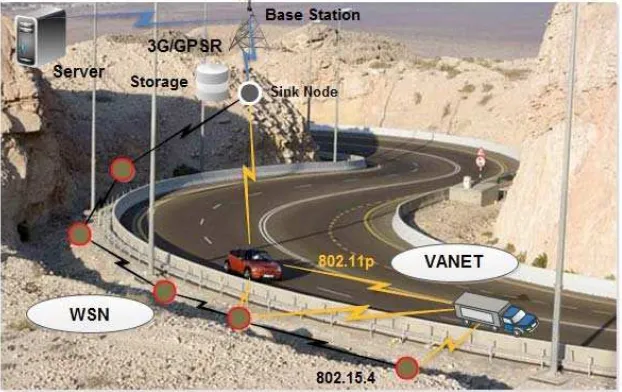
Some applications are use for traveler navigation to reducethe travel time, cost, and efficient in fuel consumption. Xia et al. [15] proposed a system for path planning and navigation, where vehicles equipped with sensors and these sensors communicate with road sensors and disseminate road condition to sink node such as speed, direction etc. Route changing andtraffic jam detection applications are mostly used navigation. The Figure 1 illustrates the architecture of WSN based VANET applications.
3. System Architecture 3.1 Usage
Our proposed architecture is best for sparse highway environment, where the base station coverage is limited because of mountains ranges and long turns. The wireless sensor nodes work efficiently there and cover the obstacles and ranges. The architecture also covers the long turn on mountains where always traffic jam because of heavy vehicles, where the vehicle nodes cannot communicate properly with base station and with other vehicles, and sensor nodes sense the density information and disseminate the information to server via base station to stop behind vehicles in time with alert messages. Another feature of proposed system is handle traffic jam and disseminates traffic information in real time mode. In proposed system vehicle can detect the traffic jam information from GPS and from other sensors in vehicles such as speed is lower than a threshold certain time period. Then vehicle send the information to near WSN sensors and then pass to sink node. Another usage of our system is preventing from accidents, because vehicles are interchange sensor data continuously over a period of time. By incorporate the information into digital map the neighbor vehicles position is appear on a digital map. Easily calculate the distance, positions, and direction of neighboring vehicles. This information is further used for preventing accidents. The Figure 2 shows the flow diagram of our proposed architecture.
Figure 2. Flow Diagram of proposed Architecture
3.2 System Components
The wireless sensor based proposed system is an intelligent navigation decision system for VANET. The system consists of four main parts: vehicle nodes, wireless sensors, Base station and Sever illustrated in Figure 3.
compare with source nodes and have more processing power and capacity. The third part is base station, where the base station is use to gather the data from sensors and from vehicles.
The server or data center is used for gather and stored all the traffic and environmental information through base station. These information and data can be used for traffic management and for forecasting. The all components of proposed system are illustrates in below Figure 3.
Figure 3. Proposed System Components
3.3 Routing
The two Ad hoc technologies WSN and VANET are implemented with their Divergentcharchterstics. The energy is not a challenge in VANET due to car batteries but WSN nodes have this problem. The VANET topology is dynamic and WSN topology is static. The architecture of proposed system based on network communication, routing techniques, middleware, and applications.
Figure 4. Protocol Architecture
3.4 System Hardware and Software
We use the HP ProLiant DL580 Gen8 Server [18] as a core of the VANET node. This is a new gen 3 technology HP server with more memory capacity and 2X faster internal storage. Other components attach with this server like LCD (touch screen), Bluetooth,camera,microphone, GPS, 802.11 wireless card as shows in Figure 5. The wireless sensor side we use TI's CC2430 chipset work as a source nodes. This tiny node contains low power 8051 micro controller, ZigBee, memory etc. The sink node is upgraded PXA270 processor SD card, GPS,LCD, USB port and touch screen etc.
Figure 5. System Hardware
In software side, the three layers are there data link, service, and presentation layer. The data link layer gather different types of data from GPS and from other sensors. The second service layer analyses the collected data and make available intelligent navigation, path planning, and messaging like text, voice and video.
4. Performance Evaluation
4.1 Simulation Scenario
The simulation is based on highway scenario and execute a straight highway model for vehicle mobility. We use NS-3 [19] for testing the highway environments with or without WSN, with the help of VANET mobility generator and NS-3 simulation. NS-3 is a discrete-event network simulator written in C++, and more accurate and efficient simulator. For highway scenario we implement Intelligent Driver Model (IDM) and MOBIL lane change model [20] in NS-3.
Table 2. Simulation Setup
Parameters Value
Length of Highway 10,000 meters
Number of lanes 1,5
Number of vehicles 20-40
Vehicle speed 50km/h-120km/h
Transmission range 200m
MAC Protocol IEEE802.11p
4.2 Data success rate
In first scenario the simulation test is based on vehicles nodes to the base station without sensors and below graph shows the average data packets received on server side. Then in second scenario, same test with implementation of wireless sensors in between vehicles nodes and base station. In our experiments, we will use real-time audio communication via VANET. In experiment the vehicles nodes are equipped with 802.11g Wi-Fi adaptor cards with omnidirectional external antenna. The below graphs shows the better average rate of proposed WSN based architecture compare to without WSN system.
Figure 6. Average delivery success rate with and without WSN
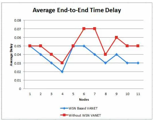
4.3 Average End-to-end time delay
Figure 7. Average end-to-end time delay
4.4 Discussion
The above section illustrated the proposed architecture results and performance in complicated roadsenvironments.The proposed architecture is better in data delivery, end-to-end time delay. In recent years any author proposed different architectures for vehicular enlivenment especially for urban or metropolitan areas. We discuss here some of them and compare with our proposed architecture.
The one of the main problem in previous systems are obstacle handling especially in hill areas where the short curves and long turns present.Through WSN based proposed architecture the exchange of information between vehicles or infrastructure will improve the driving security and efficiency as well. The much architecture have been proposed but they focused on highways plain road environments and ignored the hill areas [21],[22].
5. Conclusion
In this paper, more efficient and hybrid sensor architecture for vehicular Ad hoc network is proposed. The proposed architecture is efficient in mountain roads, where the base station not cover the long range. We discussed the system architecture its hardware and software components and implementation as well. The results proved that WSN based architecture is most efficient and better in performance compare to without WSN system. The proposed architecture can meet the requirement of data transmission and real time audio data transmission.
Acknowledgment
This research is supported by the Ministry ofEducation Malaysia (MOE) and in collaboration with Research Management Centre (RMC) Universiti Teknologi Malaysia (UTM). This paper is funded by the GUP Grant (vote Q.J130000.2528.06H00).
References
[1] Y. Zhang, L. Yang, H. Liu, L. Wu. Applications of Chaos Sequence in Intelligent Transportation
System. TELKOMNIKA Indonesian Journal of Electrical Engineering. 2013; 11: 5210-5217.
[2] KN. Qureshi, AH. Abdullah. A survey on intelligent transportation systems. Middle-East Journal of
Scientific Research. 2013; 15: 629-642.
[3] W. Franz, R. Eberhardt, T. Luckenbach. Fleetnet-internet on the road. in 8th World Congress on
[4] D. Reichardt, M. Miglietta, L. Moretti, P. Morsink, W. Schulz. CarTALK 2000: Safe and comfortable driving based upon inter-vehicle-communication. in Intelligent Vehicle Symposium. 2002: 545-550. [5] SAFESPOT Integrated Project. Available: http://www.safespot-eu.org
[6] AN. Knaian. A wireless sensor network for smart roadbeds and intelligent transportation systems.
Massachusetts Institute of Technology. 2000.
[7] JM. Bohli, A. Hessler, O. Ugus, D. Westhoff. A secure and resilient WSN roadside architecture for
intelligent transport systems. in Proceedings of the first ACM conference on Wireless network security.
2008: 161-171.
[8] D. Tacconi, D. Miorandi, I. Carreras, F. Chiti, R. Fantacci. Using wireless sensor networks to support intelligent transportation systems. Ad Hoc Networks. 2010; 8: 462-473.
[9] W. Birk, E. Osipov, J. Eliasson. iRoad—Cooperative Road Infrastructure Systems for Driver Support.
in Proceedings of the 16th ITS World Congress. 2009.
[10] H. Qin, Z. Li, Y. Wang, X. Lu, W. Zhang, G. Wang. An integrated network of roadside sensors and
vehicles for driving safety: Concept, design and experiments. in Pervasive Computing and
Communications (PerCom), 2010 IEEE International Conference on. 2010: 79-87.
[11] E. Weingärtner and F. Kargl. A Prototype Study on Hybrid Sensor-Vehicular Networks. Proceedings of
the 6th GI/ITG KuVS Fachgespräch “Wireless Sensor Networks.
[12] K. Sung, JJ. Yoo, D. Kim. Collision warning system on a curved road using wireless sensor networks.
in Vehicular Technology Conference, 2007. VTC-2007 Fall. 2007 IEEE 66th. 2007: 1942-1946.
[13] SE. Yoo, PK. Chong, T. Park, Y. Kim, D. Kim, C. Shin, et al.DGS: Driving guidance system based on
wireless sensor network. in Advanced Information Networking and Applications-Workshops, 2008. AINAW 2008. 22nd International Conference on. 2008: 628-633.
[14] W. Ying, X. Hui-bin, C. Dai-feng. A Novel Routing Protocol for VANETS. TELKOMNIKA Indonesian
Journal of Electrical Engineering. 2013; 11: 2195-2199.
[15] R. Xia, C. Ye, D. Zhang. Vehicle to vehicle and roadside sensor communication for intelligent
navigation. in Wireless Communications Networking and Mobile Computing (WiCOM), 2010 6th
International Conference on. 2010: 1-4.
[16] A. Festag, W. Zhang, L. Le, R. Baldessari. Geocast in Vehicular Networks. Vehicular Networks. 2009:
377.
[17] P. Baronti, P. Pillai, V. W. Chook, S. Chessa, A. Gotta, YF. Hu. Wireless sensor networks: A survey
on the state of the art and the 802.15. 4 and ZigBee standards. Computer Communications. 2007; 30:
1655-1695.
[18] (2014). HP ProLiant DL Server. Available:
http://www8.hp.com/us/en/products/proliant-servers/product-detail.html?oid=6636692#!tab=features
[19] TR. Henderson, S. Roy, S. Floyd, GF. Riley. ns-3 project goals. in Proceeding from the 2006
workshop on ns-2: the IP network simulator. 2006: 13.
[20] M. Treiber, A. Hennecke, D. Helbing. Congested traffic states in empirical observations and
microscopic simulations. Physical Review E. 2000; 62: 1805.
[21] JE. Naranjo, E. Talavera, JJ. Anaya, F. Jiménez, JG. Zato, N. Gómez. Highway test of V2V mesh
communications over WSN. in IEEE Conference on Intelligent Transportation Systems, Proceedings,
ITSC. 2012: 25-30.