STUDY ON RIVER MORPHOLOGY AND SAND MINING MANAGEMENT IN VOLCANIC RIVER
RESEARCH TEAM Jazaul Ikhsan Puji Harsanto
CIVIL ENGINEERING DEPARTMENT ENGINEERING FACULTY
APPROVAL
Title of Research : Study on river morphology and sand mining management in volcanic river.
Code/Name of Field of science : Engineering Chief researcher:
a. Full name : Jazaul Ikhsan, ST., MT., PhD b. NIDN : 0524057201
c. Academic rank : Lektor Kepala
d. Study program : Civil Engineering Department e. Mobile phone : +628164227363
f. e-mail : [email protected] Member of researcher (1)
a. Full name : Puji Harsanto, ST., MT., PhD b. NIDN : 0607067401
c. University : Universitas Muhammadiyah Yogyakarta International partner (1)
a. Full name : Prof. Masaharu FUJITA b. Name of institution : Kyoto University Japan
c. Address of institution : Ujigawa Open Laboratory, Disaster Prevention Research Institute TEL +81-75-611-5263 / FAX +81-75-611-5239
International partner (2)
a. Full name : Prof. Yasunori MUTO b. Name of institution : Tokushima University Japan
c. Address of institution : Department of Civil and Environmental Engineering, Tokushima University, Japan
Length of research period : 2 year Year of research : First
Total research funds : Rp 300.000.000,- (US $ 23.000 ) Research funds of current year :
- proposed to UMY Rp 300.000.000,- (US $ 23.000) - Others Rp ... (US $ ... )
- Inkind ……….
Acknowledged,
Yogyakarta, 9-July-2015
Head, Study Program Chief researcher,
No :
Tanggal :
Hal : Pengajuan Kemitraan Penelitian Internasional Lampiran :
Bersama surat ini, kami sampaikan proposal PROGRAM KEMITRAAN PENELITIAN INTERNASIONAL dengan data sebagai berikut :
Judul Program : Study on river morphology and sand mining management in volcanic river
Kategori : Kemitraan Penelitian Internasional
Fakultas : Teknik
Institusi Mitra : 1. Kyoto University Japan
Graduate School of Engineering Department of Civil and Earth Resources Engineering
: 2. Tokushima University
Department of Civil and Environmental Engineering Pengelola Program : Program Studi Teknik Sipil
Hormat kami,
4
No :
Tanggal :
Hal : Pernyataan Komitmen dan Tanggung Jawab Lampiran:
Kepada Yth.
Rektor
Universitas Muhammadiyah Yogyakarta
TEMPLAT 1
Dengan ini saya menyatakan bahwa:
1. Seluruh informasi yang kami sampaikan dalam proposal berjudul Study on
river morphology and sand mining management in volcanic river atau
lampirannya adalah absah dan sahih.
2. Menjamin terselenggaranya program ini sesuai dengan ketentuan yang berlaku di Universitas Muhammadiyah Yogyakarta.
Demikian surat pernyataan ini dibuat dengan penuh kesadaran, semoga Alloh s.w.t. meridhoi. Amiin.
Hormat kami,
Jazaul Ikhsan, ST., MT., PhD
5
SUMMARY
6
TABLE CONTENT
SUMMARY 5
CHAPTER 1. INTRODUCTION 7
CHAPTER 2. LITERATURE REVIEW 10
CHAPTER 3. RESEARCH METHODOLOGY 14
3.1 Research Planning 14
3.2. Field Study 16
3.3. Experimental Study 16
3.4 Numerical Study 18
CHAPTER 4. BUDGET AND RESEARCH PLAN 25
4.1 Budget 25
4.2 Research Plan 26
7
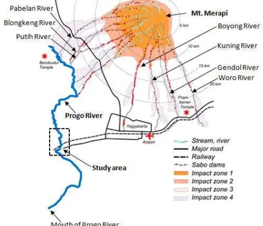
CHAPTER 1. INTRODUCTION
The river reach of Progo River system that located in Bantar is chosen in order to
examine the interaction of channel geometry, concentration of bedload and bed
deformation. The watershed area of Progo River is around 17,432 square kilometers.
Several tributaries of Progo River are located in the Mt. Merapi. The irrigation water of
Sleman and Kulon Progo Distric are taken from the river. Many structures, for example,
bridges, railway bridges, are cross the river. So, the sustainability of the river should be
monitor by Yogyakarta government. Due to the major eruption in October 2010, the
sediment supply is more than the equilibrium condition. Figure 1 shows the Progo River
system.
Figure 1 Location of study area
Mt. Merapi in Central Java, Indonesia had a major eruption on late October and
early November 2010. The eruptions produced ash plumes, lahars, and pyroclastic
8
volcanic rivers. It is approximately 130 million m3. During rainy season, the deposited
sediment flows to the downstream area and produced debris flow. The presence of
debris flow increases the possibility riverbank erosion in some river reach, causing
significant damage to various infrastructure and river structures. Hence the secondary
disaster in term of rainfall induced debris flow may occur in long term period.
The sediment deposit produced by the eruptions of Mt. Merapi has market value,
and its quality attracts sand miners. The sand mining activities have given some
advantages for rural/local people, local government and reduced sediment run off. Sand
and gravel material in Mt. Merapi offer many benefits such as employment opportunity,
and an increase in economical benefit to farmers. Total number of mining workers in
Mt. Merapi area amounts to about 21,000 man/day. The local government of Magelang
Regency obtained benefit from the sand mining activities and the regency income
increased from Rp. 236,000,000 (in fiscal 1997) into Rp. 2,218,000,000 (from fiscal
1998)4) . Klaten regency imposed a mining tax revenue of Rp 92,00,00 (in fiscal 1999)
and Sleman regency imposed a mining tax revenue of Rp 500,000,000 (in fiscal 2000).
It means that exploitation of sand and gravel material provides rural areas with
considerable opportunities for economic development. However, uncontrolled sand
mining has caused serious problems in the watershed such as unstableness of sediment
control facility, bridge and irrigation intake by digging nearby, channel and riverbank
instability due to riverbed degradation, and destruction of aquatic and riparian habitat
due to natural and artificial armoring. As long as the sand mining is controlled, it can be
one of measures for sediment control plan to give an extra empty in the sediment
9
The recent sand mining activities in Progo River tend to uncontrolled situation.
The sand miners use the pump machine to take the sand from the river. The locations of
sand mining are also near the river structures. For example, the sand mining at the
Bantar Bridge is very active. From this point, sustainable sediment management assisted
by sand mining is urgently necessary to mitigate the above issues.
Using field survey, experimental and numerical model, this research is to study (1)
the change of morphology in Progo River due to the large bedload transport from the
upstream to the downstream area and its impact on riverbed and riverbank deformation,
(2) the stability of river structure in Progo River due to the change of river morphology
and predicting in future condition (3) the amount of sand mining material that can be
dredged from the river and its impact on river structures stability. The result from this
research will be submitted in international journal, i.e. Journal of Sediment Research
and Journal of Hydro Environment Research.
The Ujigawa Open Laboratory in Kyoto University is the one of the biggest
laboratory in the world that has some experimental equipment to study the sediment
transport related disaster management. Prof. Masaharu FUJITA is the head of this
laboratory and very active for conducting the research on sediment related disaster
especially in Mt. Merapi. The research collaborations are conducted with several
universities in Indonesia. The recent joint research is namely SATREP which JICA,
Kyoto University and Gadjah Mada University are the main institutions in those
activities. And also, Prof. Yasunori MUTO (Tokushima University) conducts an
investigation the sand mining in Progo River, recently. Regarding to the activities of
both scientist, it is important to conduct research collaboration with Kyoto University
10
CHAPTER 2. LITERATURE REVIEW
The bedload transport and its impact on morphology have been studied by many
researchers. Erosion or re-suspension is one of the important processes in cohesive
sediment’s transport system (Mehta et al., 1989a and Mehta et al., 1989b). Erosion is
one of the main processes in river morphology. Many researchers have studied to clarify
the erosion behavior of cohesive sediment, involving theoretical approaches, numerical
analysis and field observations. They observed the erosion rate characteristics of
cohesive sediments considering the physicochemical parameters. Those parameters are
the salinity (Gularte et al., 1980 and Parchure and Mehta, 1985), temperature (Gularte et
al., 1980 and Nishimori and Sekine, 2009), water content (Gularte et al., 1980 and
Sekine and Izuka, 2000 ) and bulk density (Aberlea et al., and Parchure and Mehta,
1985). The results of those research show that the strength of the cohesive sediments is
controlled by many parameters and explained as follow:
the erosion resistance increases with increasing in salinity.
the erosion resistance increases with increasing in temperature.
the erosion resistance decreases with increasing in water content.
the erosion resistance decreases with increasing in bulk density.
And also, they studied the erosion characteristics of cohesive sediment bed only
using clear water as eroding media. However, the flow in natural rivers that containing
only clear water are limited by the fact that most flows in rivers have sediment transport
such as bed load, suspended or wash load. In other words, sediment transport is a
common phenomenon in natural rivers and the transport rate depends on the flow
11
flow. This phenomenon also had observed by many researchers. The research’s results
on feedback effect of sediment transport on the flow characteristics are described below.
Kamphuis (1990) observed the influence of coarse sediment transport on erosion
of cohesive bed. The test used both clear water and water containing sand as eroding
media. The experiments show the importance of the variations of hydraulic condition to
study the effect of bed-load transport in the flow. The various flow conditions are
applied to analyze the effect of bed-load transport in erosion of cohesive bed.
Song and Chin (1998) used various supplied sediment to investigate the effect of
bed-load’s movement to the flow friction factor. The experiments compared the
frictions between the flow in clear water and the flow containing both water and sand.
The results showed that the presence of bed-load increases the friction factor. In other
words, the bed load decreases the mean flow velocity. He argued that, the bed load
transport extracts momentum from the flow and causes a reduction of flow velocity.
These results give knowledge that the presence of bed-load transport can decreases the
flow velocity and also the bed shear stress.
The results between Kamphuis (1990) and Song and Chin (1998) show that the
bed load transports not only can decrease but also can increase the flow velocity. This
phenomenon was agreed by Carbonneau and Bergeron (2000). In a given hydraulic
condition, the flow that consist only clear water will produce different bed shear stress
compare to the flow which has sediment transport.
The volume of bed-load transport increases the erosion rate of cohesive sediment
when the bed-load transport rate under the small rate conditions. However, after
achieving a certain volume, the erosion rate will decrease. This tendency indicates that
12
sediment bed is a non-linear function. In fact, the volume or concentrations of the
bed-load transport effects on the magnitude of the dynamic shear stress on the bed
(Harsanto, 2012).
The bed-load transport in the real channel (in the river), which has equilibrium
and non equilibrium are not explained clearly yet. The large of sediment supply due to
the lahar material in Progo River has a potential to make the sediment transport in the
river is not in equilibrium condition. And also the season in Indonesia is dry season and
wet season, so, it is need to be investigated the volume of sediment transport both in dry
and wet season. The river structures also need to be investigated to find correlation
between sediment transport phenomenon and stability of the structures.
The Mt. Merapi's lava production data from 1890 to 1922 have been compiled by
Siswowidjoyo et al., (1995). The production volumes of individual eruption events are
varied widely from less than 1 million m3 to more than 20 million m3. The annual
average lava production rate is approximately estimated at 1.2 million m3. The sand
mining volume in the foothills (upper area) of Mt. Merapi in 2000 is estimated at 5-6 x
10 6 m3/year. The sand mining persists not only in the foothills area but also in the
dramatically. The dramatically changes of riverbed morphology will produce the non
13
which has some river structures on it. There are three bridges, i.e., highway bridge,
water supply (PDAM) bridge and railway bridge. So, it is importance to conduct an
investigation about the volume rate of sand mining and the quantities of sand that can be
pumped or dredged every day, so, the sediment transport still in equilibrium condition
and the river construction is in stable condition. And also, the predicting of
sustainability of sand mining should be investigated, because the sediment supply from
14
CHAPTER 3. RESEARCH METHODOLOGY
3.1 Research Planning
The relation among of sand mining activities, bed-load transport and river
morphology will be investigated using field survey, numerical simulation and laboratory
experiment. The research of river morphology due to the sand mining and bed-load
transport in Progo River are shown bellow.
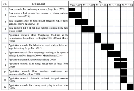
(1) Basic research: The sand mining activities in Progo River (2009)
(2) Basic research: Bank erosion characteristics on cohesive and non-cohesive
channel (2010)
(3) Basic research: Study on bank erosion processes with cohesive and non-cohesive
material (2012)
(4) Basic research: Effect of bed-load transport on erosion rate bank erosion (2012)
(5) Application research: River Morphology Modeling at the Downstream of Progo
River Post Eruption 2010 of Mount Merapi (2014)
(6) Application research: The behavior of riverbed degradation and aggradation along
Progo River (2015)
(7) Application research: River morphology modeling at the upstream of Progo River
Post Eruption 2010 of Mount Merapi (2016)
(8) Application research: River structures stability (2016)
(9) Application research: Sand mining management in Progo River (2016)
(10) Application research: River structures maintenance and management in Progo
River (2017).
(11) Application research: Automatic sediment transport recorder (2017)
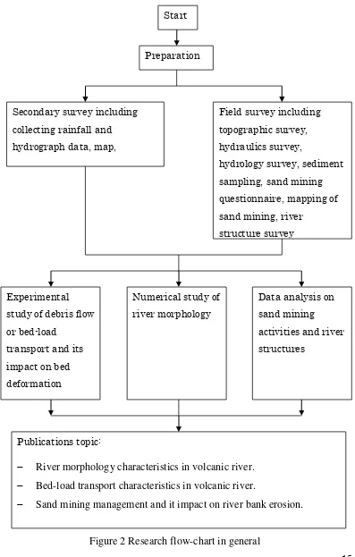
15 The flowchart of this research is shown in Figure 2.
Figure 2 Research flow-chart in general
Start
River morphology characteristics in volcanic river. Bed-load transport characteristics in volcanic river.
16
3.2. Field Study
Field data collecting are conducted in this step and will be done during dry and
wet season. The activities are shown below.
(1) Geodetic survey is conducted to get the topographic condition of the river.
The survey is located in the river reach that the changes of river morphology
will be analyzed.
(2) Hydraulics survey is conducted to get the data of flow velocity.
(3) Riverbed and riverbank material sampling.
(4) Sediment transport survey. This activity is conducted to get the volume of
bed-load transport and suspended load.
(5) The questionnaire survey consists of four parts, namely general information, rate of sand mining, socio-economic, perception on volcano hazard and sediment disaster prevention structures, and perception on impact of sediment disaster prevention structures on ecology.
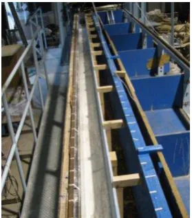
3.3. Experimental Study
Location of experiments is in Ujigawa Open Laboratory (UOL) of Disaster
Prevention Research Institute (DPRI), Kyoto University, Kyoto, Japan. The experiments
were conducted in a tilting flume channel with 8 m long. The channel has a rectangular
cross section with 0.15 m wide and 0.25 m height. Both of walls have rails on the top. A
moveable point gauge is installed on the rails. The point gauge can move in the
longitudinal and the transverse directions. Figure 1 illustrates the experimental setup
from right side. Photo 1 shows the top view of the channel.
This research is addressed for investigation of the effect of bed load transport in
17
hydraulic condition to allow comparative analysis. Several preliminary experiments are
conducted to determine the appropriate slope, discharge and size of bed load material.
The appropriate condition means that the coarse sediment particles can move as bed
load transport over the cohesive sediment bed. Also the flow condition should be set to
avoid the local erosion on the bed.
Figure 2 The experiment setup, where a) water tank, b) pump, c) rigid bed, d) cohesive sediment, e) sediment feeding location, f) horizontal view of cross sections, g) screen grid, h) downstream weir, i) downstream tank, and j) tilting machine)
Photo 1 The flume test channel and the flow direction is to bottom side
q
18
3.4 Numerical Study
Numerical simulations are performed using the horizontal two-dimensional flow
model which the equations are written in general coordinate system. The model uses the
finite difference method to solve the different equations. Relationship between
Cartesian coordinate system and General coordinate system is as follows.
.
directions in generalized coordinate system, respectively, x and y are the coordinates in
Cartesian coordinate system. Computation of surface flow is carried out using the
governing equation of the horizontal two-dimensional flow averaged with depth. The
conservation of mass, i.e., inflow and outflow of mass by seepage flow, is taken into
consideration as shown in the following equation [1].
19
Where, t is the time, z is the water surface level. Surface flow depth is represented as
h, seepage flow depth is hg. U and V represent the contravariant depth averaged flow
velocity on bed along and coordinates, respectively.
These velocities are defined as
U u v
coordinates, respectively. Ug and Vg represent the contravariant depth averaged seepage
flow velocity along and coordinates, respectively. These velocities are defined as
g g g
where, depth averaged seepage flow velocities along x and y coordinates in
Cartesian coordinate system are shown as ug, vg, respectively. is a parameter related to
the porosity in the soil, wherein = 1 as zzb, and = as z < zb, where zb is the
bed level and is the porosity in the soil. Seepage flow is assumed as horizontal
two-dimensional saturation flow. Momentum equations of surface water are as follows.
20
shear stress along and coordinates, respectively. These shear stresses are defined as
b bx by
21
obtained by depth integrated velocity field as follows [3].
2 23 2
Where, is the coefficient of kinematics eddy viscosity, is the Karman constant, kt
is the depth-averaged turbulence kinetic energy [1].
b b
Where, kgx and kgy is the coefficient of permeability along the longitudinal and the
transverse directions, respectively. When the water depth of surface flow becomes less
than the mean diameter of the bed material, the surface flow is computed only in
22
of surface flow [4].
Grain size distribution is evaluated using the sediment transport multilayer model as
follows [5]:
the depth-averaged concentration of bed-load. Ebe is the equilibrium bed-load layer
thickness; it is estimated by the following equation [6]:
*
non-dimensional shear stress of mean diameter. Esdis the sediment layer thickness on
cohesive sediment bed. Ebis the bed-load layer thickness, qbk and qbkare the bed-load
23
non-dimensional critical friction velocity of size class k is evaluated as follows [7].
Iwagaki’s formula which is formulated for uniform bed material is used for
evaluating u*cm. Kc is the correction factor due to the influence of bed inclination on
sediment motion [9].
where is the angle of deviation of near-bed flow from the x direction as follows.
arctan b
directions, respectively. These inclinations are evaluated as follows,
arctan b b
Hence, the local bed slope along direction of bed-load of sediment mean diameter
24
sinq cosmsinq x sinmsinqy (26)
where m is the deviation angle of bed-load of mean diameter to the x direction. The
deviation angle of bed-load of size class k to the x direction (k), which depends on the
flow near bed and inclination of the bed, is calculated by the following relation
2
Evolution of bed elevation is estimated by means of the following formulae.
25
CHAPTER 4. BUDGET AND RESEARCH PLAN
4.1 Budget
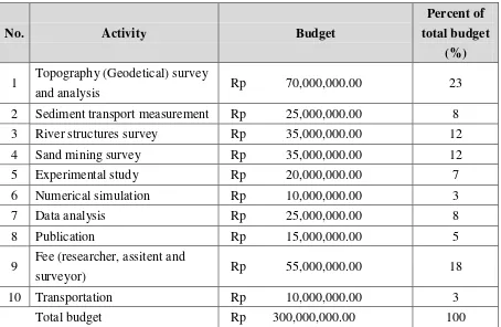
The budget of this research is shown in Table 1.
Table 1 Research budget 2016
No. Activity Budget
Percent of
total budget
(%)
1 Topography (Geodetical) survey
and analysis Rp 70,000,000.00 23
2 Sediment transport measurement Rp 25,000,000.00 8 3 River structures survey Rp 35,000,000.00 12 4 Sand mining survey Rp 35,000,000.00 12 5 Experimental study Rp 20,000,000.00 7 6 Numerical simulation Rp 10,000,000.00 3
7 Data analysis Rp 25,000,000.00 8
8 Publication Rp 15,000,000.00 5
9 Fee (researcher, assitent and
surveyor) Rp 55,000,000.00 18
10 Transportation Rp 10,000,000.00 3
26
4.2 Research Plan
The general research plan is show in Table 2.
Table 2 Research plan on river morphology of volcanic river
REFERENCES
Aberlea J, Nikorab V, and Waltersb R, Effects of bed material properties on cohesive sediment erosion, Marine Geology, Vol. 207, pp. 83-93, 2004.
Ashida, K., Egashira, S., and Kamoto, M.: Study on the erosion and variation of mountain streams, Bulletine of DPRI, Kyoto University, Vol. 25, B-2, pp. 349-360, 1982.
Ashida, K. and Michiue, M.: Study on hydraulic resistance and bed-load transport rate in alluvial streams, Proc. of JSCE, No. 206, pp.59-69, 1972.
Ashworth P.J., Mid-channel bar growth and its relationship to local flow strength and direction, Earth Surface Processes and Landform, Vol. 21, pp. 103-123, 1996.
Carbonneau, P.E., and Bergeron, N.E.: The effect of bed-load transport on mean and 2009 2010 2011 2012 2013 2014 2015 2016 2017 2018 1 Basic research: The sand mining activities in Progo River (2009)
2 Basic research: Bank erosion characteristics on cohesive and non-cohesive channel (2010)
3 Basic research: Study on bank erosion processes with cohesive and non-cohesive material (2012)
4 Basic research: Effect of bed-load transport on erosion rate bank erosion (2012)
5
Application research: River Morphology Modeling at the Downstream of Progo River Post Eruption 2010 of Mount Merapi (2014)
6 Application research: The behavior of riverbed degradation and aggradation along Progo River (2015)
7 Application research: River morphology modeling at the upstream of Progo River Post Eruption 2010 of Mount Merapi (2016) 8 Application research: River structures stability (2016)
9 Application research: Sand mining management in Progo River (2016)
10 Application research: River structures maintenance and management in Progo River (2017).
11 Application research: Automatic sediment transport recorder (2017)
12 Application research: River management policy in volcanic river (2018).
Research Plan Year
27 turbulent flow properties, Geomorphology, Vol. 35, pp. 267-278, 2000.
Dapporto, S., Rinaldi, M., Casagli, N., and Vannocci, P.: Mechanisms of riverbank failure along the Arno river, central Italy, Earth Surf. Process. Landforms, Vol. 28, pp. 1303–1323, 2003.
Egashira, S. and Ashida, K.: Unified view of the mechanics of debris flow and bed-load, Advances in Micromechanics of Granular Materials, (Edited by H.H.Shen et al.) Elsevier, pp. 391-400, 1992.
Engelund, F., Flow and Bed Topography in Channel Bends, Journal of Hydraulic Div., ASCE, Vol. 100, No. HY11, 1974.
Egashira, S., Miyamoto, K., and Itoh, T.: Constitutive equations of debris flow and their applicability, Proc. 1st Int. Conf. on Debris-Flow Hazards Mitigation,
New York: ASCE: pp.340-349, 1997.
Gabel, S.L. and Bridge, J.S.: Flow and sediment dynamics in a low sinuosity, braided river: Calamus River, Nebraska Sandhills, Sedimentology, Vol. 39, pp125-142, 1992.
Gularte, R.C., Kelly, W.E., and Nacci, V.A.: Erosion of cohesive sediments as a rate process, Ocean Engng, Vol. 7, pp. 539-551, 1980.
Hooke, J.M.: An analysis of the processes of river bank erosion, Journal of Hydrology, Vol. 42, pp. 39-62, 1979.
Hooke J.M., The significance of mid-channel bars in an active meandering river,
Sedimentology, Vol. 33, Issue 6, pp. 839–850, 1986.
Iwagaki, Y.: Hydrodynamic study on critical shear stress. Proc. of JSCE, No. 41, pp. 1-21, 1956.
Jiongxin, X.: Underlying gravel layers in a large sand bed river and their influence on downstream-dam channel adjustment, Geomorphology, Vol.17, pp. 351–
359, 1996.
Kamphuis, J.W.: Influence of sand or gravel on the erosion of cohesive sediment, J.
of Hyd. Research, Vol. 28, No. 1, pp. 43-53, 1990.
Kovacs, A. and Parker, G.: A new vectorial bedload formulation and its application to the time evolution of straight river channels. J. Fluid Mech. Vol. 267, pp. 153-183, 1994.
Liu, B.Y.: Study on Sediment Transport and Bed Evolution in Compound Channels. Thesis presented to Kyoto University, 1991
28 Mehta, A.J., McAnally, W.H.J., Hayter, E.J., Teeter, A.M., Schoellhamer, D., Heltzel, S.B., and Carey, W.P.: Cohesive sediment transport. I: Application, J.
of Hyd. Eng., ASCE, Vol. 115, No. 8, pp. 1094-1112, 1989.
Nagata, N., Numerical Analysis of the 2-Dimensional Unsteady Flow Using a Generalized Coordinate System, The Lecture Collection on the Computer Use in Hydraulic Engineering, The Japan Society of Civil Engineers, pp. 51 –
76, 1999.
Nishimori, K., and Sekine, M.: Studies on soil erosion processes and erosion kinetics sticky, Journal Japan Society of Civil Engineers, B JSCE, Vol. 65 No. 2, pp. 127-140, 2009. (in Japanese)
Parchure T.M, and Mehta A.J, Erosion of soft cohesive sediment deposit, Journal of
Hydraulic Engineering, ASCE, Vol. 111, No. 10, pp.1308-1326, 1985.
Sekine M and Iizuka N, Erosion rate of cohesive sediment, Proceeding Int. Confernce,
Hamburg, 2000.
Sekine, M., Nishimori, K., Fujio, K. and Katagiri, Y.: On erosion process of cohesive sediment and erosion rate formula, Annual Journal of Hy. Eng. JSCE, Vol. 47, pp. 541-546, 2003
Simon A., Curini A., Darby S.E., and Langendoen E.J.: Bank and near-bank processes in an incised channel, Geomorphology, Vol. 35, pp. 193-217, 2000. Shimizu,Y. and Itakura,T., Calculation of Flow and Bed Deformation with a
General Non-Orthogonal Coordinate System, Proc. of XXIV IAHR Congress,
Spain, C-2, pp.41-48, 1991.
Song, Y.M., and Chin, C.O.: Effect of bed-load movement on flow friction factor,
Journal of Hydraulic Engineering, ASCE, Vol. 124, No. 2, pp. 165-175,1998
Takebayashi, H., Egashira, S. and Okabe, T.: Braided streams formed on beds with non-uniform sediment, Proc. 3nd IAHR Symposium on River, Coastal and
Estuarine Morphodynamics, pp.787-798, 2003.
Takebayashi, H., River Configuration in Middle-Lower Reach of River Basin,
Journal of Japan Society of Fluid Mechanics, Vol. 24, pp. 27-36, 2005.
Thompson, C.E.L., and Amos, C.L.: Effect of sand movement on a cohesive substrate,
Journal of Hydraulic Engineering, ASCE, Vol. 130, No. 11, pp. 1123-1125,
29
SUMMARY OF RESEARCH COLLABORATION WITH RESEARCH
PARTNER.
Jazaul Ikhsan, ST., MT., PhD, Puji Harsanto, ST., MT., PhD and Prof. Masaharu
FUJITA
1. Harsanto, P., Takebayashi, H., and Fujita, M.: Study on bank erosion processes with
cohesive and non-cohesive material, Proceeding Annual Meeting of Japan Society of
Erosion Control Engineering, JSECE Publication, No.66, pp. 288-289, 2012.
2. Harsanto, P., Toan, N.M.M., Takebayashi, H., and Fujita, M.: Effect of bedload
transport on erosion rate of cohesive sediment, Journal of Japan Society of Civil
Engineers, Ser. B1 (Hydraulic Engineering), JSCE, Vol. 68, No. 4, pp. I_19 – I_24,
2012.
3. Harsanto, P., Takebayashi, H., and Fujita, M.: Numerical analysis on
countermeasures of bank erosion, Proceeding Int. Symposium on Sediment Disasters
under the Influence of Climate Change and Tectonic Activity (2nd), JSECE
Publication, No.63, pp. 44-45, 2011.
4. Harsanto, P., Toan, N.M.M., Takebayashi, H., and Fujita, M.: Erosion characteristics
of cohesive sediment by non-cohesive sediment, Annuals of Disas. Prev. Res. Inst.,
Kyoto Univ., No 54 B, pp. 611-618, 2011.
5. Ikhsan, J., Fujita, M., and Takebayashi, H.: Study on sediment disaster and resources
management in Mount Merapi area, Proceeding of Annual Meeting of Japan Society
of Civil Engineers, JSCE, pp. 497-498, September, 2010.
6. Ikhsan, J., Fujita, M., and Takebayashi, H.: Sediment disaster and resource
management in the Mount Merapi area, Indonesia, International Journal of Erosion
Control Engineering, Vol.3, No.1, 2010.
7. Ikhsan, J., Fujita, M., and Takebayashi, H.: Impacts of sediment management on
socio-economic and environment in Mt. Merapi area, Proceeding of Annual Meeting
of Japan Society of Erosion Control Engineering, JSECE Publication No.57, pp.
30
8. Fujita, M., Ikhsan, J., and Takebayashi, H.: Impacts of sediment management on
socio-economics and environment in Mt. Merapi area, Proceeding of International
Workshop on Multimodal Sediment Disasters Triggered by Heavy Rainfall and
Earthquake and the Countermeasures, pp. 87-96, March, 2010.
9. Ikhsan, J., Fujita, M., and Takebayashi, H.: Study on sediment management in
volcanic area by considering disasters mitigation and resources management,
Proceeding of International Workshop on Multimodal Sediment Disasters Triggered
by Heavy Rainfall and Earthquake and the Countermeasures, pp. 67-76, March,
2010..
31
Latter of Agreement
Prof. Masaharu FUJITA
32
Supporting in research:
The activity in Kyoto is an experimental investigation that study the impact of debris flow
on channel bed deformation. Flume Test in Ujigawa Open Laboratory (UOL) is under
Disaster Prevention Research Institute (DPRI), Kyoto University Kyoto Japan. The
channel flume test is a tilting flume channel with 8 m long. The channel has a
rectangular cross section with 0.15 m wide and 0.25 m height. Both of walls have rails
on the top. A moveable laser point gauge is installed on the rails. This experimental test
34
Workshop Civil Engineering Laboratory
List of equipments that will use in this research are shown below.
1. Digital Teodollite, topography survey to get channel geometry.
2. Camera, documentation survey.
3. PC, numerical simulation.
4. Sediment trapping, sampling the sediment transport in river.
5. Current meter, measure flow velocity in river.
6. Sieve equipment, riverbed material gradation (coarse material).
7. Geomatical equipment, riverbed material gradation (fine material).
35
Curriculum Vitae
Name IKHSAN JAZAUL
Citizenship Indonesia
Birth/Place May 24, 1972, Yogyakarta, Indonesia
Academics
Ph.D. Student (2007 - 2010)
Department of Civil and Earth Resources Engineering, Graduate School of Engineering, Kyoto University, Japan
M.Eng. in Hydraulic Engineering (1999-2003)
Department of Civil and Environmental Engineering,
Graduate Studies Program Gadjah Mada University, Yogyakarta, Indonesia
B.E. in Civil Engineering (1992-1998)
Department of Civil Engineering and Environmental Engineering, Faculty of Engineering, Gadjah Mada University, Yogyakarta, Indonesia
Jobs
1998 – present
Lecturer in Civil Engineering Department, Engineering Faculty, Universitas Muhammadiyah Yogyakarta
Publications
Ikhsan, J., Fujita, M., and Takebayashi, H.: Study on sediment disaster and resources management in Mount Merapi area, Proceeding of Annual Meeting of
36 Ikhsan, J., Fujita, M., and Takebayashi, H.: Sediment disaster and resource management in the Mount Merapi area, Indonesia, International Journal of
Erosion Control Engineering, Vol.3, No.1, 2010.
Ikhsan, J., Fujita, M., and Takebayashi, H.: Impacts of sediment management on socio-economic and environment in Mt. Merapi area, Proceeding of Annual Meeting
of Japan Society of Erosion Control Engineering, JSECE Publication No.57, pp.
472-473, May, 2010.
Fujita, M., Ikhsan, J., and Takebayashi, H.: Impacts of sediment management on socio-economics and environment in Mt. Merapi area, Proceeding of International Workshop on Multimodal Sediment Disasters Triggered by Heavy Rainfall and
Earthquake and the Countermeasures, pp. 87-96, March, 2010.
Ikhsan, J., Fujita, M., and Takebayashi, H.: Study on sediment management in volcanic area by considering disasters mitigation and resources management,
Proceeding of International Workshop on Multimodal Sediment Disasters Triggered
by Heavy Rainfall and Earthquake and the Countermeasures, pp. 67-76, March,
2010.
Ikhsan, J., Fujita, M., and Takebayashi, H.: Sediment disasters and sediment resources managements in Mount Merapi area, Proceeding of Asia-Pacific Symposium on New Technologies for Prediction and Mitigation of Sediment
Disasters, JSECE Publication No. 55, pp. 106-107, November, 2009.
Ikhsan, J., Fujita, M., and Takebayashi, H.: Sustainable sand mining management in Merapi area using groundsills, Annuals of the Disaster Prevention Research
Institute, Kyoto University, No.52B, pp. 647-657, June, 2009.
Ikhsan, J., Fujita, M., and Takebayashi, H.: Sand mining impacts on socio-economic inhabitant and river bed variation in Merapi area, Proceeding of Annual Meeting of
Japan Society of Erosion Control Engineering, JSECE Publication No.52, pp. 50-51,
37 Ikhsan, J., Fujita, M., Takebayashi, H. and Sulaiman, M.: Concepts on sustainable sand mining management in Merapi area, Annual Journal of Hydraulic
Engineering, JSCE, Vol.53,pp. 151-156, February, 2009.
Ikhsan, J., Sulaiman, M., and Fujita, M.: A study on sustainable sediment management in Merapi volcanic area, Proceeding of Fourth International
Conference on Scour and Erosion (ISCE-4), pp. 553-557, November 2008.
Ikhsan, J., Sulaiman, M., and Fujita, M.: Study on sustainable sand mining management in Merapi volcanic region, Proceeding of Annual Meeting of Japan
Society of Erosion Control Engineering, JSECE Publication No.50, pp. 338-339,
May, 2008.
38
Curriculum Vitae
Profile
Name Puji Harsanto
Citizenship Indonesia
Birth/Place June 7, 1974, Yogyakarta, Indonesia
Academic
1. Ph.D., Doctoral degree in Civil Engineering (2009 - 2012) Department of Civil and Earth Resources Engineering, Graduate School of Engineering, Kyoto University, Japan
2. M.T., (Master degree in Hydraulic Engineering (2002-2007) Department of Civil and Environmental Engineering,
Graduate Studies Program Gadjah Mada University, Yogyakarta, Indonesia
3. S.T., Bachelor degree in Civil Engineering (1992-1998)
Department of Civil Engineering and Environmental Engineering, Faculty of Engineering, Gadjah Mada University, Yogyakarta, Indonesia
Jobs
1. 2013 – present
Lecturer in Civil Engineering Department, Engineering Faculty, Universitas Muhammadiyah Yogyakarta
2. 1999 – 2012
Lecturer in Civil Engineering Department, Engineering Faculty, Universitas Wijayakusuma Purwokerto
Publications
- Harsanto, P., River Morphology Modeling at the Downstream of Progo River Post Eruption 2010 of Mount Merapi, Proceeding Annual Conference, 5th International Conference on Sustainable Future for Human Security, SustaiN 2014
- Harsanto, P., Evaluasi kondisi hidraulika di sungai vulkanik pasca letusan gunung merapi 2010, studi kasus Jembatan Bantar Sungai Progo, Proceeding National
39 - Harsanto, P., Takebayashi, H., and Fujita, M.: Study on bank erosion processes with cohesive and non-cohesive material, Proceeding Annual Meeting of Japan Society of Erosion Control Engineering, JSECE Publication, No.66, pp. 288-289, 2012.
- Harsanto, P., Toan, N.M.M., Takebayashi, H., and Fujita, M.: Effect of bedload transport on erosion rate of cohesive sediment, Journal of Japan Society of Civil Engineers, Ser. B1 (Hydraulic Engineering), JSCE, Vol. 68, No. 4, pp. I_19 – I_24, 2012.
- Harsanto, P., Takebayashi, H., and Fujita, M.: Numerical analysis on countermeasures of bank erosion, Proceeding Int. Symposium on Sediment Disasters under the Influence of Climate Change and Tectonic Activity (2nd), JSECE Publication, No.63, pp. 44-45, 2011.
- Harsanto, P., Toan, N.M.M., Takebayashi, H., and Fujita, M.: Erosion characteristics of cohesive sediment by non-cohesive sediment, Annuals of Disas. Prev. Res. Inst., Kyoto Univ., No 54 B, pp. 611-618, 2011.
- Takebayashi, H., Fujita, M., and Harsanto, P.: Bank Erosion Model along Banks Composed of both Cohesive and Non-cohesive Material layers, Annuals of Disas. Prev. Res. Inst., Kyoto Univ., No 53 B, pp. 527-536, 2010.
- Harsanto, P., Fujita, M., Takebayashi, H., Legono, D., and Fathani, F.: Flow characteristics of Sesayap River, East Kalimantan Province, Indonesia, Proceeding of International Workshop on Multimodal Sediment Disasters Triggered by Heavy Rainfall and Earthquake and the Countermeasures, pp. 175-186, 2010
- Takebayashi, H., Fujita, M., and Harsanto, P.: Numerical analysis of bank erosion process along banks composed of both cohesive and non-cohesive layers, Proceeding of International Workshop on Multimodal Sediment Disasters Triggered by Heavy Rainfall and Earthquake and the Countermeasures, pp. 77-86, 2010
- Harsanto, P., Takebayashi, H., and Fujita, M.: Effect of cohesive material on bank erosion process in Sesayap River, East Kalimantan Province, Indonesia, Proceeding Annual Meeting of Japan Society of Erosion Control Engineering, JSECE Publication, No.57, pp. 254-255, 2010.