JAVANESE SETTLEMENT’S SPATIAL DESIGN
TOWARDS LOCAL WISDOM-BASED DISASTER MITIGATION
Case Studies: Mount Bromo and Merapi Volcanic Settlements
1Catharina Dwi Astuti Depari2, University of Atma Jaya Yogyakarta, Indonesia
Some successful disaster management especially in East Asia have demonstrated how the local wisdom could contribute not only to maintain the place identity of the region but also to increase the resilience of its communities toward disaster impacts. A new approach integrating local wisdom with current science is continously developed and therefore, a bottom up approach in which community’s aspirations are accomodated must be well-considered in urban planning and design. In urban design context, spatial ordering system could symbolize local values in which inherited knowledge towards disaster mitigation is embedded. As the consequences of living in regions prone to volcanic hazards, communities in Bromo and Merapi have inherited methods to dealing with volcanic impacts and are expressed through their cultural traditions and spatial design. The research aims to emphasize local wisdom as an essential element that contributes to increase the community’s resilience towards volcanic impacts and to strengthen place identity towards globalization influences. The research employs interpretive-historical and ethnography approaches in which local and researcher’s perceptions-based interpretations toward the local wisdom, culture, spatial design and volcanic disaster phenomenon are established.
Key words: local wisdom, ordering system, disaster mitigation, volcanic impacts, spatial design
INTRODUCTION
The geographical position of Indonesia which is traversed by the world’s most active volcanoes causes the region to be highly vulnerable to volcanic impacts (Basyid, 2010). Inspite of this fact, because of the volcano’s enormous natural benefits, the tendency of population concentrated in areas prone to volcanic hazards still increased. Following this phenomenon, physical developments accomodating the needs for investment or living intensively emerge and then encourage land conversions from forestland to other uses. These practices would lead the region’s disaster risk to a worrying level where the safety and the well-being of its inhabitants become more endangared. Responding to this challenge, urban designers are compelled to produce a proper spatial design concept that contributes to reduce the disaster risks by considering not only the physical conditions of the area but also its local values in their design process. This design approach corresponds to what is currently emphasized by all city planners in which place identity becomes a major concern. Over the last decade, all cities around the world including those in Indonesia confront enormous consequences from the ongoing phenomenon of globalization and the tendency to disregarding traditional values whether it is in policymaking, urban design or in formulating a disaster mitigation platform (Dekens as quoted by Maarif, et al., 2012). Basically, integrating local knowledge with modern science is not an easy task because of the nature of the knowledge which is mostly emerged from spiritual beliefs. Therefore, it is important to recognize the local values which are relevant to mitigation purposes and to current context in order to ensure that the implementation of the local wisdom-based disaster mitigation model could be run effectively.
1 This paper represents the researcher’s concerns toward cultural and disaster phenomenon and is being prepared by the researcher for pursuing a Doctoral degree in urban design and city planning specifically in the University of Washington, USA.
2 Lecturer at Department of Architecture, Faculty of Engineering, University of Atma Jaya Yogyakarta, Indonesia, e-mail: [email protected], contact number/ mobile phone: +62-8132-810-2088
Many historical documents demonstrate that Indonesian ancestors usually emphasize the importance of living in harmony with nature and as return, they would receive a protection guarantee upon their lives. The ancestors gradually developed their understanding toward nature’s characteristics by learning from each eruption event. These lessons are accumulated and then converted into laws or norms, sometimes through folklore or mtyhs, and finally characterize the local’s customs and spatial design. For instance is the local knowledge evolved in the ancient settlements around Mount Merapi since Megalithic civilization. The volcano is believed as a cosmic kingdom inhabited by spiritual spirits to whom the traditional ceremony Labuhan Gunung is intended. The purpose of this ceremony is to conjure a life protection from any harm and to deliver a reverence to the spirits. In addition to this, there is social norm stressing the importance of avoiding any conducts that intrude the harmony of nature. Violation to this rule would trigger a disaster which symbolizes the God’s anger (Fatkhan, 2006). Beside the myth, there is a folklore explaining the capability of Merapi community to predict eruption event based on local’s observations toward the wild deer or primates’ behavior (Iskandar as quoted by Permana & Nasution, 2011).
Jencks (1977), Bonta (1979) and Broadbent (1980) defined architecture as a system of signs that connotes ideology, function or certain qualities and a tool to communicate particular ideas or messages to its observers. In urban design context, local values are manifested not only through cultural traditions but also through the spatial design of the environment. By studying the correlation between the local wisdom, the knowledge towards volcanic disaster mitigation, culture and spatial design of the settlements under study, the current volcanic disaster mitigation platform of each area would expectedly be much improved. The research aims to emphasize local wisdom as an essential element that contributes to increase the community’s resilience towards volcanic impacts. The case studies include all settlements around two most prominent volcanoes in Indonesia, Mount Bromo and Merapi, where mystical rites and ancestral traditions still exist until today. Two questions derived from this research background are:
• How is the local knowledge towards volcanic disaster mitigation reflected through local culture and transformed into spatial design of each settlement under study?
• How is the local knowledge towards volcanic disaster mitigation in each settlement under study adapted with recent needs and modern values?
For the local authorities, the research results would provide guidelines to formulate a proper volcanic disaster mitigation plan, policy or mechanisms based on local values while for the community, it would offer an alternate approach of guidance to dealing with volcanic impacts in which indigenous knowledge, local’s needs and aspirations are well-adopted and integrated with modern science. The research results would also contribute to enhance the academic understanding towards local wisdom and its role to increase the resilience of one community in dealing with volcanic impacts and to maintaining identity towards globalization influences.
BACKGROUND THEORY
Local Wisdom and Its Correlation with Architecture
Local wisdom is defined as a system of norms that influences the daily living of one community and provides guidance to governing men’s behavior, attitudes or manners not only in their relationship with other people but also with nature (Zulkarnain and Febriamansyah as quoted by Permana & Nasution,
2011). In terms of social-cultural relationship, capability of orienting attitudes toward local values would determine someone’s social status among other members of his or her community (Geertz as quoted by Ernawi, 2010). Beside the norms, local wisdom also contains moral messages or knowledge which are expressed through spritual rites and traditions. These activities are mainly aimed to remind all men about the importance of establishing sensitivity towards their environments with deep respect.
Being generated from local wisdom, indigenous knowledge specifically focuses on subjective knowledge of one region which includes social and economic structure, religious beliefs, needs, expectation and all types of knowledge created by the local people. Indigenous knowledge is continuously developed and adapted to gradually changing environments and inherited through generations and therefore, it is closely interwoven with people’s cultural values. Brokensha, Warren and Werner (1980) defined indigenous knowledge as an accumulated knowledge, traditional skills and technology of a people, culture, or subculture which encompasses both technical and non-technical knowledge including world view, social and religious customs, taboos, vegetation, climate, ecology, communication patterns and music. The nature of indigenous knowledge is dynamic and is continually influenced by internal creativity and experimentation as well as by contact with external systems (Flavier et al. 1995: 479).
In terms of Bromo and Merapi, the local’s indigenous knowledge is mostly embedded in folklore and myth. Folklore conveys knowledge, moral messages or common values of the community by using storytelling as its mode (Soepanto as quoted by Casuarina, 2003). Folklore is vulnerable to changes because its continuity entirely depends on those who spread the story. Similar with folklore, myth is aimed to deliever values while the difference with folklore lies on its direct impact to the believers in a way that it governs man’s attitude within his society. Beside values, myth contains spiritual beliefs toward the almighty God and thus, it means sacred to the believers (Bascom as quoted by Casuarina, 2003).
Javanese Philosophy and Its Influences to Spatial Ordering System
Philosophy is a thinking framework or a mind system that assists human beings to obtain a solution over their problems which relates to a matter of life, truth, goodness and God (Ronald, 1988). The Javanese thinking framework emphasizes harmonious relationship between man, other people, nature and God which is called manunggaling kawula lan Gusti3 in local term. This thinking is resulted from a trans-cultural process that encounters the cultural values of Java, Hindu and Islam in which the receiving culture is encouraged to find its new identity. Javanese people also believe that all men should responsible for their conducts which are manifested through symbols or particular pattern of their living spaces. Utilizing particular symbol or pattern in Javanese spatial design is not aimed for aesthetical expression, but to remind all men about their moral obligations. In other words, the use of symbols or the manner of ordering spaces in Java primarily consider the heavenly reasons rather than the wordly reasons (Hadinoto as quoted by Setyowati, 2007).
3Manunggaling kawula lan Gusti is a Javanese teaching, also termed tasawuf in Arabic and has been developed since XVII and XIX century. This teaching means the union between citizen with King as the representative of God which could be obtained by establishing a self-awareness (Maharsiwara, 2006).
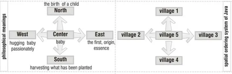
Scheme 2. Implementation of Mancapat into the Javanese spatial ordering system Source: Rejeki, 2010
The spatial ordering system in Javanese traditional cities is generally based on Hindu’s ancient concept called as mancapat, and adopt a concentric type of spatial pattern (Tjahyono as quoted by Setyowati, 2007). Mancapat or kiblat papat lima pancer in Javanese term means the manner of dividing one entity into five components by referring to each direction of the four earth’s main cardinal points and one central point. From cosmological point of view, this pattern shows the Sultan’s palace as the most significant element which symbolizes the presence of God and the transedental relationship between macro-cosmic (universe of God also called buana agung) and micro-cosmic (universe of men or the world of alit) (Karsono, 1996). Beside concentric pattern, Javanese traditional cities also adopt axial type through a corridor that connects two main natural elements of the city, mountain and sea, where the mythological spirits are believed to live and rule.
Figure 1. Implementation of Hindu’s cosmic concept that affects the spatial ordering system of Yogyakarta Source: www.kompasiana.com, 2011
The volcanic settlements around Mount Bromo and Merapi are selected to be the research’ case studies because of some reasons, which are: 1) the status of Bromo and Merapi as two most prominent volcanoes in Indonesia where knowledge towards disaster mitigation is inherited and then characterizes the culture of their settlements. 2) the status of those volcanic regions as historical sites where the trans-cultural process encountering the ideology of Java, Hindu and Islam occured and characterized the culture of their settlements; 3) the local’s cultural traditions are mostly based on mystical beliefs but are potential to improve the quality of the current disaster mitigation plan; and 4) the rich experience of each community in both regions could provide benefits for acquiring a better urban spatial design concept which regards to local values and disaster mitigation efforts.
Defining the Cultural Characteristics of Tengger and Merapi
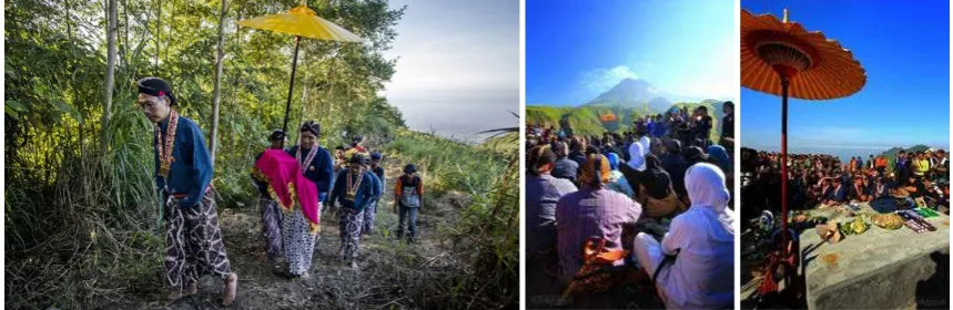
The status of Tengger belongs to ancient community living around Mount Bromo which is predicted to exist since the era of Megalithic civilization. Tengger settlements are administratively located within the territory of East Java Province and welknown for their mystical beliefs. These beliefs are resulted from the trans-cultural encounters between Megalithic and Hindus civilitation, and then influences the local’s traditions until the present time. Regarding eruption event, the local people perceive it as a symbol of God’s blessing and therefore, reverence must be delivered to the God by performing Kasodo ritual tradition. But recent observation indicates a tendency of declined number of Tengger communities which still maintain their ancestral traditions because of the impacts from globalization (Sutarto, 2006). Facing this phenomenon, one figure called Dukun Pandhita is selected by the local community to responsible for sustaining the Tengger’s values and cultural traditions (Warouw, 2012:viii).
Figure 2. Kasodo ritual tradition, aiming to commemorate the anniversary of Tengger and to express a reverence towards God
Source: www.gunung-bromo.com, 2011
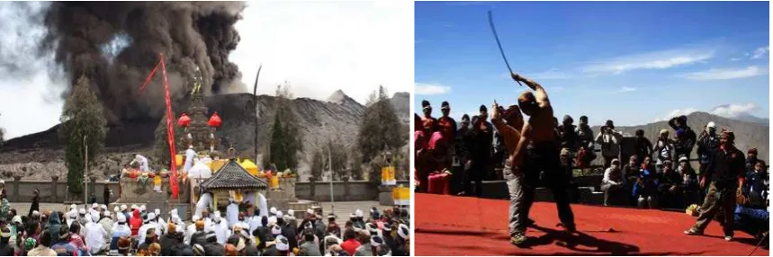
In terms of Merapi, its volcanic settlements are administratively located within two Javanese provinces’ territories which are Central Java Province and Special District of Yogyakarta. Being welknown as the most active volcano in Indonesia, Merapi’s eruption event in 1,006 A.D. was assumed to be the main factor that causing the massive mobilization of the Mataram Kingdom’s ancient community from Central Java to East Java Province. In cultural context, although the local custom is now dominantly influenced by Islam, but some ancient traditions based on Hindu’s belief and mysticsm still exist until today. For instance is what the Merapi community believes toward an eruption event. The people see this event as a symbol of God’s anger, contrary to what the Tenggers believe. The Merapi community‘s conceptions toward the volcano are basically constructed by associating it with mystical powers for which the shamanism-based practices are aimed (De Coster as quoted by Maarif, 2012:3). The volcano is believed as a cosmic temple where the spiritual spirits inhabit while the peak is perceived as the residence of two supreme mythological figures, Kanjeng Ratu Sekar Kedathon and Kiai Sapujagad, who have full-jurisdictions over the volcano land.
Figure 3. Labuhan Gunung Merapi, a ritual expressing reverence or adoration to the spiritual ruler of Merapi Source: www.tempo.co, 2014 (left) and www.travel.detik.com, 2012 (center and right)
In order to conjure life protection, Merapi community performs a traditional rite called Labuhan Gunung which is also aimed to regain harmonious relationship between men, nature and the Almighty after previously being disturbed (Fatkhan, 2006). Beside the rite, Merapi’s traditional rules are resulted from an amalgamation process between animism, Hindus and Islam and include the prohibition of providing grass for the livestock, hunting the wild animals and planting seeds in areas which are the domains of the holy spirits. Any violation against these rules causes an agony which affects not only the transgressor but also the whole society living around Merapi (Fakhtan, 2006:108). Therefore, it is important to maintain a harmonious relationship with nature under the principle nrimo ing pandum4 by preserving the ancestral traditions and avoiding any conducts that could hurt the volcano (Fakhtan, 2006:109).
Spatial Pattern as Architectural Symbol of Values
According to Rapoport (1977), there is a strong correlation between culture, behavior, activity and architecture in which a three-dimensional experience of one observer is created. Architecture could be seen as a tool to visualize symbolic values or spirit of place to which the manner of ordering spaces is oriented (Schultz, 1980). Regarding its function of being a mode of symbolic values, architecture has three main aspects needed to explore which are: (1) contend aspect that describes the meaning of architecture based on local perception; (2) container aspect that describes space, physical appearance and form, urban areas or buildings; and (3) context aspect that considers all aspects of architecture and is related to container aspect (Rapoport as quoted by Haryadi and Setiawan, 2010).
Scheme 1. Correlation between culture, behavior, activity and setting system
4Nrimo ing pandum is one of Javanese philosophical teaching which means to accept reality as a part of man’s life by being grateful for what has been given by the Almighty.
Source: Haryadi and Setiawan, 2010
Spatial pattern is physical feature characterizing architecture through which architecture expresses particular ideas, values or messages. Lynch (1960) described three types of spatial pattern among which is city of faith where a cosmic order becomes the main factor determining how the city elements are arranged. The spatial pattern usually adopted by this city type is axial pattern in which a direct relationship between men and God is emphasized through the existence of one main corridor (Shane, 2005).
Figure 4. Various types of urban spatial pattern based on Trancik’s figure ground theory Source: Trancik, 1986 redrawing by the researcher, 2014
In addition to this, Trancik (1986) also suggested various types of urban spaces based on figure ground relationship. As seen from figure 4, there are six typological patterns suggested by Trancik which are grid, random organic, curvilinear, angular, radial concentric and axial. These distinct types of urban spaces contribute not only to urban design but also to create the people’s perceptions toward their environments.
RESEARCH METHOD
Interpretive-Ethnography Approaches
The research paradigm is phenomenology which is aimed to study how local wisdom towards volcanic disaster influencing the ordering system of spaces in each volcanic settlement. The strength of this research method is its sensitivity towards meanings, process of the artifacts including people’s activities. Despite the strength, there is a weakness of the method in which the unstructured data must be coded are very enormous and the analysis would be relatively time consuming. Based on the research questions, approaches best-suited for the research work are interpretive-historical and ethnography in which the in-depth engagement with the research subject is strongly emphasized. The aspects of the research include cultural, social and setting system which is based on Sardjono, et al.’s categorization towards culture (2013).
Scheme 2. Research Fishbone Diagram
Interpretive-historical research requires deep investigations into social-physical phenomena within a complex context with a view toward explaining those phenomena in a holistic fashion. Its strength lies on its ability to explain past events in a narrative way and to provide a means of getting in to a context or event in the past. The tactic includes making use of archival, interview, archaeological, visual inspection and other kinds of material evidences. Interpretivism derives from phenomenological tradition and aimed to understand the complex world or lived experience from the point of view of those who live it. Establishing objective interpretations is not an easy task because it entirely depends upon emplotment and literary construction and beside that, the object of inquiry is not empirically available for performing observations. Multiple narrational perspectives on phenomena or objects under study could potentially occur and therefore, awareness towards this approach’s weakness should be anticipated (Groat and Wang, 2002:166-167).
Ethnography approach is not aimed to produce an explanatory theory that is applicable to all settings, and the characteristics are defined by its fully consistent to using context-rich detail in holistic exploration towards one setting, its reliance upon unstructured data, its focus on single case or small number of cases and its emphasis on meanings and functions of human action. Ethnography approach entirely depends on participant observation as the primary mode of data collection in which the role determination to lesser or higher degree in the phenomena under study
or the stance of either an insider or an outsider in subject areas are established by the researcher (Groat and Wang, 2002:182-183).
Scheme 3. Research Thinking Framework
FOCAL THEORY
Disaster Mitigation Platform based on Local Wisdom
Disaster is defined as a sudden ecological phenomenon of sufficient magnitude that requires external assistance. It is also defined as any event, typically occurring suddenly that causes damage, ecological disruption, loss of human life, deterioration of health and health services and which exceeds the capacity of the affected community on a sufficient scale to require outside assistance (Landsman as quoted by Sena & Michael, 2006:2). The impacts resulted from a disaster are consequences should be anticipated from living together with nature and therefore, an effective research-based disaster mitigation that contributes to increase the community’s safety should be
formulated especially in areas proned to massive impacts. Disaster mitigation is a vital systematic effort that provides a number of principles, strategies or techniques that could decrease the loss possibility of one suffering area (Permana and Nasution, 2011). Mitigation is also defined as permanent reduction of the disaster risk which includes effort of recognizing the disaster event that will occur in order to reduce the harmful effects of a disaster and to limit their impact on human suffering and economic assets (Sena & Michael, 2006:3).
In this time of era, new inventions derived from scientific research and technology-based approaches are continously developed to support the attempts of formulating an effective disaster mitigation. Since 1990’s, there has been a tendency in urban planning to adopt local values although the process of integrating these values with the modern ones is difficult to perform. Despite this fact, local values should be seen as a potential tool to increase one community’s resilience towards disaster impacts especially in this time era where place identity becomes a major concern in city planning. Disaster mitigation formula accomodating local knowledge, aspirations and needs would logically be more successfull in its implementation and be more effective to reducing the future disaster impacts rather than that which only employs the modern values in a way that the techniques induced into the formula are much familiar to the local people and thus, easily grasped or recognized. Some regions which have successfully implemented this approach in their disaster mitigation management are those in Philipines, Indonesia and Timor Leste including those in Bangladesh which was collaboratively iniated by the local scientists and USAID.
Based on literature study towards local wisdom in Bromo and Merapi regions, the local knowledge is mostly embedded in folklore and myth. Through folklore and myth, the knowledge is believed to be more effectively delivered, transferred and absorbed by the local community. Therefore, folklore and myth could be key sources of information describing the local values, including their meanings and purposes. The challenge would rise when attempting to differentiate values which are consciously aimed for disaster risk reduction from those which are not. The solution could be obtained by conducting a regular discussion with the local informants including those whose expertise is in the subject area.
Disaster Phenomenon in Mount Bromo and Merapi
As mentioned before, local knowledge could be an effective tool to increase the community’s resilience against the future destructive impacts of the volcano because its existence entirely depends on local’s experience and understanding towards the volcano. The local people must have gradually developed knowledge and skills to recognize the sign from nature even before the eruption event occurs and therefore, adopting this traditional knowledge could support the improvement of current disaster mitigation model.
Historical records of Merapi’s eruptions indicate that most of its eruption events caused a devastating impact although the knowledge towards the disaster has long been developed and
maintained since the prehistoric time. Two disruptive eruption events of Merapi that occured in 1672 and 1930 had been blamed to cause approximately thousands of death victims. In case of Bromo, the eruption events are recorded more frequently than those in Merapi, but the death victims is relatively low. This could be resulted from not only the fact that Merapi’s characteristics are more destructive than Bromo’s, but also the tendency of ignorance of the local community towards local wisdom which is potential to reduce the impacts from Merapi’s eruptions.
SUMMARY AND CONCLUSIONS
As suggested by Rapoport (1979) that there is a strong correlation between culture, behavior, activity and architecture. Therefore, by studying how the local wisdom in each case study correlates to disaster mitigation purposes, cultural traditions and spatial design, an ideal disaster mitigation platform coincided with a deep grasp towards its historical transformation could be obtained.
It has been explained that the correlation between local wisdom, knowledge towards volcanic disaster mitigation, culture and spatial design could be revealed through interpretive-historical and ethnography approaches in a way that these methods provide techniques to interprete the phenomena and all aspects related to them based on both the local’s and the researcher’s perceptions. There are some awareness should be anticipated when conducting this research. First, the weakness of interpretive-historical and ethnography methods in that there is vast amount of unstructured data should be analyzed which is time consuming. Second, the object of inquiry in both research approaches could not be empirically obtainable. Third, the difficulties to seperate ancient values which are directly correlated to mitigation purposes from those which are not, and forth, the possibility for multiple narrational perspectives to occur.
Regarding volcanic disaster mitigation, the local wisdom which is a product of the past must compromize with today criteria or be relevant to nowdays context in order to ensure that the local wisdom-based disaster mitigation model could be well-adapted with recent needs and be more effective in its implementation. The degree in which the local wisdom will be integrated with modern values depends on the local’s needs and reference. By analyzing the physical and non physical conditions of each case study including its tendency to adapt with modern needs and cultural transformations, it could be identified the local’s reference towards their future cultural and environmental characteristics as well as the most applicable disaster mitigation model.
Bibliography
Anon., 2011. [Online]
Available at: www.gunung-bromo.com [Accessed on 18 October 2014].
Basyid, M. A., 2010. Pengembangan Peta Rencana Kontijensi Bencana Gunung Api Studi Kasus: Gunung Api Lokon. Jurnal Rekayasa , December, XIV(4), pp. 216-226.
Bonta, J. P., 1979. Architecture and Its Interpretations, A Study of Expressive Systems in Architecture. London: Lund Humphries.
Brokensha, D., Warren, D. & Werner, O., 1980. Indigenous Knowledge Systems and Development. Washington D.C.: University Press of America.
Bromo, P. W., 2011. Upacara Kasada, Tradisi Adat Budaya Ritual Suku Tengger Bromo. [Online] Available at: www.gubung-bromo.com
[Accessed on 18 October 2014].
Detik, T., 2012. Upacara Labuhan Merapi. [Online] Available at: www.travel.detik.com
[Accessed on 18 October 2014].
Ernawi, I. S., 2010. Harmonisasi Kearifan Lokal Dalam Regulasi Penataan Ruang. s.l., s.n., pp. 1-21.
Fatkhan, M., 2006. Kearifan Lingkungan Masyarakat Lereng Gunung Merapi. Jurnal Aplikasi llmu-ilmu Agama, Desember, VII(2), pp. 107-121.
Flavier, J., 1995. The Regional Program for the Promotion of Indigenous Knowledge in Asia. s.l.:s.n.
Groat, L. & Wang, D., 2002. Architectural Research Methods. New York: John Wiley & Sons, Inc..
Group, T. M., 2011. Prosesi Labuhan Gunung Merapi. [Online] Available at: www.tempo.co
[Accessed on October 2014].
Haryadi & Setiawan, B., 2010. Arsitektur Lingkungan dan Perilaku:Pengantar ke Teori, Metodologi dan Aplikasi. Yogyakarta: Gadjah Mada University Press.
Jencks, C., 1977. The Language of Post Modern Architecture. New York: Rizzoli.
Karsono, D., 1996. Thesis: Kajian Perubahan Bentuk Tata Ruang Lingkungan Permukiman di Kauman Surakarta. Semarang: UNDIP, Program Pascasarjana Magister Teknik Arsitektur..
Lynch, K., 1960. The Image of The City. Cambridge: The M.I.T. Press.
Maarif, S., Pramono, R. & Kinseng, R. A., 2012. Kontestasi Pengetahuan dan Pemaknaan Tentang Ancaman Bencana Alam, Studi Kasus Ancaman Bencana Gunung Merapi. Jurnal Penanggulangan Bencana, III(1), pp. 1-13.
Maharsiwara, S., 2006. Moslems in the Javanese Culture Pularlism and the Palace Art Performance. Humaniora, October, 18(3), pp. 226-235.
Norberg-Schultz, C., 1980. Genius Loci: Towards a Phenomenology of Architecture. New York: Rizzoli International Publication, Inc..
Permana, R. C. E. & Nasution, I. P., 2011. Kearifan Lokal tentang Mitigasi Bencana pada Masyarakat Baduy. Makara Sosial Humaniora, Juli, XV(1), pp. 67-76.
Rapoport, A., 1977. Human Aspects of Urban Form Towards A Man-Environment Approach to Urban Forms and Design. London: Pergamon Press.
Ronald, A., 1988. Manusia dan Rumah Jawa. Yogyakarta: Penerbit JUTA Yogyakarta..
Rosiana, M., 2002. Thesis: Kajian Pola Morfologi Ruang Kawasan Pecinan Semarang, Semarang: UNDIP: Program Magister Teknik Arsitektur.
Sardjono, A., Budihardjo, E., Pangarsa, G. & Prianto, E., 2013. Arsitektur dalam Perubahan Kebudayaan. s.l.:s.n.
Sena, L. & Michael, K. W., 2006. Disaster Prevention and Preparedness. Ethiopia: USAID.
Setyowati, E., 2007. Karakteristik Ruang Kawasan Dalam Beteng Kraton Yogyakarta. Forum Teknik, pp. 197-272.
Shane, D. G., 2005. Recombinant Urbanism: Conceptual Modelling in Architecture, Urban Design and City Theory, London: John Wiley & Sons, Ltd..
Sutarto, A., 2014. Sekilas Tentang Masyarakat Tengger. [Online] Available at: http://kebudayaan.kemdikbud.go.id
[Accessed on September 2014].
Trancik, R., 1986. Finding Lost Space. New York: Van Nostrand Reinhold Company.
Warouw, J. N. et al., 2012. Inventarisasi dan Komunitas Adat Tengger Ngadisari Sukapura Probolinggo Jawa Timut. Yogyakarta(D.I.Yogyakarta): Balai Pelestarian Nilai Budaya DIY.
MAP OF THE VOLCANIC SETTLEMENTS AROUND MOUNT BROMO
MAP OF THE VOLCANIC
SETTLEMENTS AROUND MOUNT MERAPI