Evaluation of the Nutritional Environment for Rice in Cianjur, Indonesia
for Development of an Advanced Basin Model for Asia
Koki Homma
a,*, Gunardi Sigit
b, Handarto
c, Masayasu Maki
d, Chiharu Hongo
e, Koshi
Yoshida
f, Kazuo Oki
g, Hiroaki Shirakawa
h, Tatsuhiko Shiraiwa
a, Ritsuko Hara
a, Mitsuo
Kambayashi
a, Yoshihiro Hirooka
a, Hiroki Iwamoto
aa Graduate School of Agriculture, Kyoto University, Kyoto, Japan b Regional Office of Food Crops Service West Jawa Province, Indonesia
c
Human Resource Development, Universitas Padjadjaran, Indonesia d
Graduate School of Global Environmental Studies e
Center for Environmental Remote Sensing, Chiba University f Collage of Agriculture, Ibaraki University
g Institute of Industrial Science, the University of Tokyo h
Graduate School of Environmental Studies, Nagoya University
* Corresponding author: Graduate School of Agriculture, Kyoto University, Sakyo-ku, 6068502, Kyoto, Japan. Tel.: +81 75 753 6042; fax: +81 75 753 6065.
Abstract
Food production systems in tropical Asia face the following problems: 1) increased demand for production; 2) increasing environmental load; 3) water scarcity and 4) effects of climate change. To overcome these problems, strategies for better management of crop and environmental resources are recommended. Here, we describe our research in Cianjur, Indonesia under the project ―Development and Practice of Advanced Basin εodel in Asia – Toward Adaptation to Climate Change‖. The study area, Cianjur, is one of the main rice production areas in Indonesia, and has water reservoirs that supply water to Jakarta. However, excess nutrients from agricultural land cause environmental problems. In this situation, evaluation of the nutritional environment for rice growth is necessary. We have begun to evaluate the nutrient concentrations in the irrigation water, soil and plants. The relationships of these nutrient contents to rice growth were analyzed using a rice growth simulation model. The simulation model and remote-sensing technologies were used in combination to evaluate the geographic distribution of rice growth and nutritional environment. The research produced baseline information for developing the Advanced Basin Model.
Keywords: environmental problem, irrigation water, remote-sensing, simulation model, soil solution
Introduction
Food production systems in tropical Asia face the following problems: 1) increased demand for production; 2) increasing environmental load; 3) water scarcity and 4) effects of climate change. To overcome these problems, strategies for better management of crops and environmental resources are recommended.
most productive area. These examples indicate that the present management is insufficient for coping with unfavorable conditions. Management variability may thus be the key to attaining production stability.
The high fertilizer input required by modern agriculture technology often exceeds an acceptable amount in the field and increases the environmental load. To optimize the input, the available nutrients in the soil and the requirements of the plant should first be evaluated. Because water scarcity is predicted in the future, the available water supply should also be evaluated.
The project “Development and Practice of Advanced Basin Model in Asia – Toward Adaptation to Climate Change”
As mentioned above, the present situation demands not only a production increase, but also management optimization based on resource evaluation. Because the smallest water management unit is a basin and nearly all excess nutrients move with the water stream in the basin, a strategy to overcome these problems must be developed at the basin scale. Here, we established
the project ―Development and Practice of Advanced Basin εodel in Asia – Toward Adaptation to
Climate Change‖ supported by the εinistry of the Environment, Japan.The project includes the evaluation of environmental resources and crop production, proposals for better management and also the establishment of an environmental conservation community. The Citarum River in Indonesia and the Num Ngum River in Laos were selected as test sites (Oki, 2011). This evaluate the geographic distribution of rice growth and then nutritional environment.
Overview of research area and activities
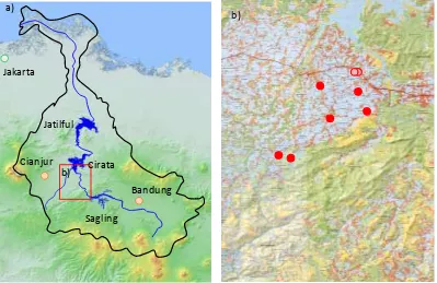
The research area is in the hydrographic basin of the Citarum River in West Java, Indonesia. The basin includes Bandung, the third largest city in Indonesia, and a total of 5 million people live in the area (Fig. 1a). Because the river is heavily polluted by human sewage and agriculture, the Asian Development Bank has called it the world‘s dirtiest river and approved a loan for clean-up in 2008. The river has 3 dams and one of 3 dams directly supplies water for Jakarta; thus clean-up of the river is of urgent concern.
Field observations have been conducted in the Bojongpicung and Ciranjang districts, Cianjur regency, West Java. The area is located between the Saguling and Cirata reservoirs and is downstream of Bandung. We selected 40 paddy fields, of which 30 were planted with rice and 10 were planted with soybeans in August 2011 (Fig. 1b). In addition to the chemical properties of the soil, the nitrogen and phosphate concentrations of soil solutions are periodically monitored. Because the nutrient concentrations in irrigation water are also measured along 3 points in the major channels, the nutritional environment for crop growth can be assessed in terms of nitrogen and phosphate levels.
b)
Bandung
Cianjur
Jatilful
Cirata
Sagling
a)
Jakarta
b)
We selected 30 rice fields from 6 locations () and 10 soybean fields from 2 locations (o). Irrigation water is periodically monitored at 6 locations for rice fields.
Figure 1. Maps of the hydrographic basin of the Citarum River (a) and the field observation site (b).
Strategies for analysis and evaluation
To develop strategies for managing crop production in the hydrographic basin, the geophysical distribution of environmental resources and crop growth must be evaluated. However, the data we obtain are point-based. Accordingly, a method that scales up from point to area is needed. Satellite-based remote-sensing can be used for this purpose, and one of the co-authors of this paper had already developed a method that has been adapted in an agricultural area of Japan (Nuarsa et al. 2011). However, obtaining satellite images for analysis is difficult because the area often obscured by clouds.
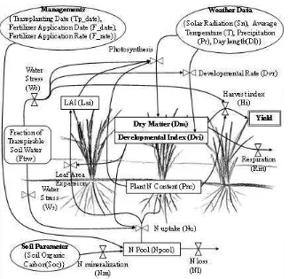
The basic concept of the model is derived from SIMRIW (SImulation Model for RIce Weather relations, Horie et al. 1995), and modified for rainfed rice production in Northeast Thailand (Homma and Horie, 2008).
Figure 2. Schematic illustration of the rice growth simulation model.
Conclusions
Here, we describe one of our activities in Cianjur, Indonesia. To develop better management practices for overcoming environmental problems and adapting to climate change, evaluation of the nutritional environment and rice growth are necessary. For this purpose, we have begun to evaluate the nutrient concentrations of irrigation water, soil solutions and plants. The relationship between these nutrient concentration and rice growth will be analyzed using a rice growth simulation model. The simulation model and remote sensing technologies will be used in combination to evaluate the geographic distribution of nutritional environment and rice growth.
Acknowledgement
The project is supported by the Environment Research and Technology Development Fund, Ministry of the Environment, Japan (E1104).
References
Homma K and T Horie. 2008. The present situation and the future improvement of fertilizer applications by farmers in rainfed rice culture in Northeast Thailand. In: LR Elsworth and Paley WO (Eds.) Fertilizers: Properties, Applications and Effects. Nova Science Publishers, N.Y. 147-180.
Horie T, H Nakagawa, HGS Centeno and M Kropff 1995. The rice crop simulation model SIMRIW and its testing. In Modelling the Impact of Climate Change on Rice in Asia (Matthews, R. B. et al. eds.), CAB International, Oxon, UK. p.51-66.
Maki M and K Homma 2011. Development of Simulation Model to Evaluate Geographical Distributions of Rice Growth and Yield in Relation to Weathers, Varieties and Fields. Proc. Annual Meeting of Society of Environmental Science, Japan in 2011.
Nuarsa IW, F Nishio and C Hongo. 2011. Spectral characteristics and mapping of rice plants using multi-temporal landsat data. J. Agric. Sci. 3: 54-67.
Oki K. 2011. Development and Practice of Advanced Basin Model in Asia. Proc. Annual Meeting of Society of Environmental Science, Japan in 2011.
Shiraiwa T, H Nakagawa, T Horie, T Matsui and K Homma. 2001. Variability in rice production and precipitation in Thailand. Chikyukankyo 6: 207-215. (in Japanese)
Tsuno Y. 1995. Clarification of actual situation and cultivation management problem in cool summer damage on rice production in Japan in 1993. Research Project Number 06304012. Research Report of Grants-in-Aid for Scientific Research, MEXT and JSPS, Japan. Pp. 233. (in Japanese)
Yoshino M, K Urushibara,-Yoshino, W Suratman. (2000) Agricultural production and climate change in Indonesia. Global Environ. Res. 3: 187-197.