77:20 (2015) 99–105 | www.jurnalteknologi.utm.my | eISSN 2180–3722 |
Jurnal
Teknologi
Full Paper
D
EVELOPMENT OF
R
APID
L
OW
-C
OST
LARS
P
LATFORM
FOR
O
IL
P
ALM
P
LANTATION
Nasruddin Abu Sari
a, A Ahmad
a, MY Abu Sari
a, S Sahib
a, AW Rasib
ba
Faculty of Information and Communication Technology Universiti
Teknikal Malaysia Melaka, Malaysia
b
Faculty of Geoinformation and Real Estate, Universiti Teknologi
Malaysia, Malaysia
Article history Received
17 May 2015
Received in revised form
30 June 2015
Accepted
23 June 2015
*Corresponding author
[email protected]
Graphical abstract
Abstract
The need to produce high temporal remote sensing imagery for supporting precision agriculture in oil palm deserves a new low-altitude remote sensing (LARS) technique. Consumer over the shelf unmanned aerial vehicles (UAV) and digital cameras have the potential to serve as Personal Remote Sensing Toolkits which are low-cost, efficient, rapid and safe. The objectives of this study were to develop and test a new technique to rapidly capturing nadir images of large area oil palm plantation (1 km2 ~ 4 km2). Using 5 different multi-rotor UAV models
several imagery missions were carried out. Multi-rotors were chosen as a platform due to its vertical take-off and landing (VTOL) feature. Multi-rotor’s VTOL was crucial for imagery mission success. Post processing results showed that for an area of 1 km2, it needs 2 to 6 sorties of quad-rotor UAV with 4000x3000 pixel digital
cameras flying at altitude of 120m above ground level and an average of 50m cross-path distance. The results provide a suitability assessment of low-cost digital aerial imagery acquisition system. The study has successfully developed a decent workhorse quad-rotor UAV for Rapid Aerial Photogrammetry Imagery and Delivery (RAPID) in oil palm terrain. Finally we proposed the workhorse UAV as Low-Altitude Personal Remote Sensing (LAPERS) basic founding element.
Keywords: Oil Palm, LARS, UAV, RAPID, LAPERS, precision agriculture
© 2015 Penerbit UTM Press. All rights reserved
1.0
INTRODUCTION
The art of fine farming has been all but lost in today oil palm mass-production. Instead of individual crops being given exact needed amounts of fertilizers, nutrients and pesticides, entire fields are treated uniformly. Equal distribution of fertilizers and nutrients
that damages certain crops and unwantedly polluting watersheds. Therefore it is not uncommon oil palm plantation exhibits within-estate spatial variation (see Figure 1). To alleviate these problems a sustainable oil palm plantation management e.g. Precision Agriculture (PA) has to be in the production ecosystem. Oil palm plantation spatial variation also partly results from relevant bio-physical and environmental factors
that influence the palm tree’s phenology. The palm tree
integrates the effects of soil, water, nutrition, pests &
disease, climate and planters’ practices, thus revealing
the results in the oil palm plantation vigour. Remote sensing techniques allow the plantation to be monitored and the palm trees status to be assessed.
1.1 Oil Palm Precision Agriculture
Accurate, reliable and high temporal spatial information is needed for a sustainable oil palm plantation management, especially data on plant quality and health [1], [2]. Monitoring characteristics of oil palm plantation is beneficial and important for oil palm planters as reported by [3], [4], [5]. Currently, data collection for oil palm plantation planning and management depend mainly on conventional methods of manually scouting sample surveys in the field. Identifying the basic important characteristics of oil palm plantation using this conventional method is quite time consuming and costly [1]. There are quite a few efforts to address this issue by employing Earth Observation Satellites based remote sensing [6], [7], [8], [9], however they are quite costly and the data are available in less timely manner. Therefore the need to produce high temporal remote sensing imagery for supporting precision agriculture in oil palm deserves a new low-altitude remote sensing (LARS) technique [10]. LARS will offer not only low in flying altitude but more importantly low operational cost in long run and yet able to produce desired outputs. Most of time LARS will produce better quality output (i.e. higher spatial resolution) compared to conventional remote sensing [6]. These outputs are necessary as they will be finally transformed into actionable input to oil palm farmers, growers, planters and agronomist alike. Hence oil palm precision agriculture (OPPA) [2], [11], [12] actual
operational spatial data will largely come from LARS platform.
1.2 Unmanned Aerial Vehicle for LARS
In the last few years, various types of unmanned aerial vehicles (UAV) have been developed to acquire high-resolution aerial imagery. Throughout the years, UAV systems have evolved rapidly due to the exponential progress of accessible technology which includes microcontrollers, micro electro-mechanical sensors (MEMS) and brushless motor. Recent advancements in battery technology, miniature autopilot systems and digital cameras have allowed the development of robust and compact unmanned systems suitable to acquire commercial-quality aerial imagery for a number of diverse purposes, from promotional aerial videos to crop condition monitoring. UAVs come in two main types: fixed-wing and multi-rotor. Fixed-wing UAVs are ideal for mapping areas up to 20 km2 (2,000
hectares). They typically have flight duration of up to 1-2 hour, which could allow an area of 50-300 hectares to be photographed per flight, and are typically less than 2m in wingspan 4kg in weight. Multi-rotor UAVs (example see Figure 2) have a shorter flight duration, but have the advantage of vertical take-off and landing, the ability to hover to acquire oblique or panoramic imagery and are, typically, less than 1m in length and 3kg in weight.
The new proposed LARS technique has to be safe, efficient, rapid and low-cost. Consumer over the shelf (COTS) unmanned aerial vehicle (UAV) and digital cameras have the potential to serve as Personal Remote Sensing toolkits [13] which are low-cost, efficient, rapid and safe. Until recently, common fixed-wing micro-UAVs have been quite popular in acquiring oil palm digital aerial imagery (DAI). These DAI photos later shall be stitched together and produced into large monolithic orthophoto such as depicted in Figure 5.
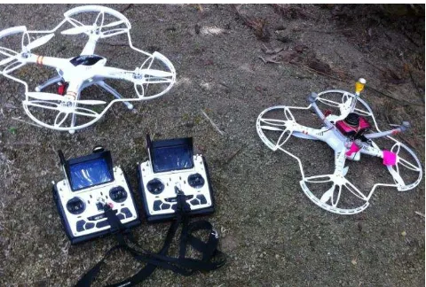
Figure-2 Walkera X350Pro quad-copters UAV with digital
camera
1.2 Objectives of Study
The objectives of this study were to develop and test a new technique to rapidly capturing high resolution nadir images of large area oil palm plantation (1 km2 ~
4 km2) using micro low-cost UAV. Using several
multi-rotor UAVs models imagery missions were carried out. These imagery trial missions were executed as a procedure to assess the potential and performance of each UAV model to become an oil palm mapping workhorse.
2.0
MATERIALS AND METHODS
Initially multirotor were preferred over fixed-wing as an aerial surveying platform due to fixed-wing limited ability to perform take-off and landing in oil palm plantation terrains. Vertical take-off and landing (VTOL) feature of multi-rotor was crucial factor for most of our missions’ success. However lightweight multi-rotor poses a different limitation compared to fixed wing, its total way-points maximum distance is generally limited to 5km - 9km per sortie only. Presently the deciding factor for this limitation is LiPo battery power density. We are simply using the commonly available LiPo battery in the market.
Fixed-wing UAVs have both advantages and disadvantages in comparison to multi-rotors counterparts. Generally fixed-wing UAVs tend to be more forgiving in the air in the face of both piloting and technical errors, as they have natural gliding capabilities with no power. Fixed-wing UAVs also are able to carry greater payloads for longer distances on less power.
2.1 Materials and Equipment
Basically the materials and equipment that we need are as follow: UAVs, digital camera & its fixtures, radio control transmitter (Tx), LiPo/camera batteries & its chargers, telemetry unit & its ground control station software, photogrammetry software, proper oil palm plantation as test field and quite powerful workstation to run the post-processing jobs on big data. We also need a bright and calm day (preferably morning time). A collection of 5 different multi-rotors UAV models were used in this study and one fixed-wing airplane was included as comparison. All of them were electric powered. Fixed-wing RC airplane Skywalker model 2012, from Event38 Unmanned Systems Inc., Akron Ohio, USA was first acquired and became precursor equipment for this study. However subsequently after a few preliminary trials it was dropped out as the terrain and environment in oil palm field were less favourable to fixed-wing UAV hence it became a comparison member only. Additionally fixed-wing requirement dictate the lowest safe altitude (LSALT) for aviation is generally 304.8 m (1000 ft.) and our 80m – 120m (AGL) planned missions are just barely adequate for a SkyWalker 2m span fixed-wing UAV safety buffer.
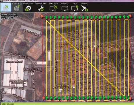
Figure-3 Surveying 1km2 will require 22.4 km mapping route
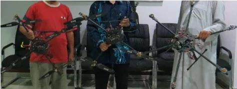
Progressively 5 separate multi-rotors came into scene of our testing arena as we initially adopted hobby grade quad-rotor and hexa-rotor manufactured by (Walkera Technology Co. Ltd., Guangzhou, China) as test platform. Walkera products are using customized variant of open-source ArduPilot Mega (APM-based) flight controllers. We had opted Walkera multi-rotors for low-price reason although after few crashes they were no longer low-cost as intended. Quad-copter X350 Pro, hexa-copter Tali H500 and quad-copter Scout X4 were modified with digital camera fixture. We also had enabled them to do mapping waypoints via auto flight mode. Subsequently we had also assembled 2 quad-copter using components over the shelf (COTS) namely Kumbang v1 and Kumbang v2 (Figure 4). All the UAVs when in missions are carrying the same unit of Canon HS260 digital camera, which is interchangeable between UAVs airframe. Partial setup details of the models were tabulated in Table 3. Chemistry of batteries used for the entire model UAVs was lithium polymer (Li-Po). The flying weight of the models was gauged using a digital weighing scale with a resolution of 1 gram. Experimental flights were performed in calm air (wind speed < 5 km/h) and “straight and level flight” was maintained with near-zero vertical speed during data acquisition. Radio transmitter used for the flight control was the Devention Devo F12E.
In all missions the key goal is the ability to generate orthophoto from the captured photos. There will be
1000’s of photos. So we need a big and fast memory
Figure-4 Kumbang V2 and its variants held by authors
2.2 Methodology and Missions
We begin with pre-planning mission or mapping an area of 1km square with 5cm ground sample distance (GSD) per pixel – as shown in Figure 3 usually we need to fly fixed-wing UAV for a total distance of 25km (average) way-points at elevation of 120m above ground level (AGL). Our initial numbers and values are crossed checked using mapping calculator as illustrated in Figure 3. We had flew several missions (sorties) to find the best match-up of UAV horizontal speed, AGL height and inter-stripe distance (cross paths distance). The goal of the missions is to optimize way-points and right-sizing the individual sortie so the equivalent coverage of a single fixed-wing sortie can be achieved. Different area-sectioning techniques e.g. multiple field-quadrants are also being tested as to optimize best routing.
For mapping an area of 1km square with 4cm ground sample distance (GSD) per pixel usually we need to fly fixed-wing UAV for a minimum total distance of 18 – 25 km (average) survey way-points at elevation of 120m above ground level (AGL). We had flew several missions (sorties) to find the best match-up of UAV horizontal speed, AGL height and inter-stripe distance (cross paths distance) using 5 different multi-rotor models (Walkera quad-copter X350, quad-copter X400 hexa-copter H500 and Kumbang quad-copter X620 & X600) carrying Canon HS260 digital camera as common payload. The goal of the missions is to optimize way-points and right-sizing the individual model sortie so the equivalent coverage of a single fix-wing sortie can be achieved. We are using mapping tool provided in an open-source software Mission Planner v1.25 to generate Table 1 and Table 2 respectively. Different area-sectioning techniques e.g. field quadrants are also being tested as to optimize best routing. In all way-points generated and sorties executed the key goal is the ability to generate stitch-able photos as to ensure quality orthophoto from the captured photos. Later stitching softwares were used to post-process the captured photos.
3.0 RESULTS AND DISCUSSION
3.1 Missions Results
Our entire missions’ results (shown in Table 3) indicate that regular consumer low-cost digital cameras and low-cost quad-rotor UAV can be used for LARS in large area oil palm plantation. Additionally the results also confirmed that a low cost LARS system is well suited for acquiring 'RAPID' high spatial and temporal resolution images. The oil palm digital aerial imageries (DAI) were immediately processed on the field (in low resolution) to produce conformation photogrammetric output such as digital elevation model (DEM) and orthophoto (as in Figure 5). All these photogrammetric products were successfully produced and subsequently assessed for initial validity without any prior measured ground check point (GCP).
3.2 Discussion and Finding
We had started with a fixed-wing UAV. Multi-rotors were chosen as an unmanned mapping platform due to fixed-wing’s take-off and landing constraints in oil palm plantation terrains. Vertical take-off and landing (VTOL) feature of multi-rotor was very crucial for mapping mission success in oil palm fields’ landscape. However lightweight multi-rotor poses a different limitation compared to fixed wing, its way-points total travelling distance is generally limited to 5km - 9km per sortie only. This is inherited to batteries capacity limitation.
In the beginning we were intrigued with these figures. Hence we set our study to seek the real world oil palm field outcomes and performance of 5 multi-rotor models. Our results showed that for an area of 1km square, we need minimum of 2 to 6 sorties of quad-rotor UAV with 4000x3000 pixel digital cameras flying at altitude of 120m AGL and a minimum of 50m cross-path distance. Each sortie would consume at least 15 minutes (minimum) flight time, traveling distance 5km (minimum) and horizontal speed about 8 m/s. Mathematically with 5000x4000 pixel camera the mission could be reduce into minimum of 1 - 5 sorties only due to the virtue of higher cross-path distance, hence less number of flying strips. However the actual
Figure 5 Orthophoto of Kumbang v2 single sortie (1.7km width)
real world situation will finally dictate the figures and results. Cross winds, gusts, undulated terrains all add-up
to contribute the overall mission’s success.
Table 1 Mission’s Parametersrequired for mapping 1 km2 area with desired GSD 4 cm and 120m AGL
Table 2 Best ‘Green Spot’ tuned with desired GSD 4 cm and 120m AGL
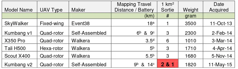
Table 3 Entire Missions Results for all 5 UAV Models (note - red box is for Kumbang v2 using ‘Green Spot’)
Model Name UAV Type Maker
Mapping Travel Distance / Battery
1 km2
Sortie Weight
Date Acquired
(km) # gram
SkyWalker Fixed-wing Event38 18a 1 3500 11-Oct-13
Kumbang v1 Quad-rotor Self-Assembled 6b & 9c 3 2300 2-Feb-14
X350 Pro Quad-rotor Walkera 3.5d 6 1010 3-Mar-14
Tali H500 Hexa-rotor Walkera 5b 3 1710 4-Apr-14
Scout X400 Quad-rotor Walkera 5.5b 3 1680 5-Nov-14
Kumbang v2 Quad-rotor Self-Assembled 9b & 14c
2 & 1
1820 11-May-15Type of Lithium Polymer (LiPo) battery used: a 5-cell 5000 mAh, b 6-cell 5000 mAh, c 6-cell 10000 mAh, d 3-cell 5000 mAh.
We cannot just simply rely of exact mathematical calculation and estimation given by mission planner. Hence we need multiple sorties for each model in order to complete 1-km2 coverage safely and
efficiently. This also brings up the possibility of scaling the mapping survey tasks. Scalability is an important element of a functional oil palm spatial toolkit. For a larger area e.g. 4 km2– perhaps we need 4 units of
quad-rotor and launch them simultaneously into 4 separate missions. Since we are using cheap cameras and cheap UAVs - this feat is economically achievable.
Theoretically by virtue of using 4 concurrent quad-rotors, a 4 km2 DAI can be acquired within the same
amount of time taken to complete 1-km2 coverage.
obliged to safety practice in conducting UAV aerial survey. Looking back at the Kumbang v2 performance improvement over its predecessor Kumbang v1 gives us better motivation in closing the gap of multi-rotor versus fixed-wing mapping capability. Kumbang v2 has been tuned to match 4 cm GSD expected performance of 120M AGL, 75% forward-overlap, 40% path sidelap calculation as shown on Table 2. This configuration is termed ‘Green
Spot’. Although it is not thoroughly tested yet, we are
targeting an operational single sortie of 1-km2
coverage from Kumbang v2 fitted with 10000mAh LiPo battery. Green Spot is where cameras resolution, camera aperture speed, flight height, flight speed and other important contributing parameters are tuned and matched up to give the greenest performance. Measurement of performance is done by comparing the number of minimum sorties (which will determine total number of strips required) against achievable GSD resolution. We just started our journey
of investigating Kumbang v2’s Green Spot.
4.0 CONCLUSION
4.1 Summary
Decent hobby-grade quad-rotor and hexa-rotor UAV had comparably performed oil palm mapping like its fixed-wing counterpart plus an additional bonus of VTOL. Due to this, we got motivated to assemble our own versions with the goal to get better performance. In this study we had successfully developing decent workhorse multi-rotor UAVs (i.e. Kumbang v1 and Kumbang v2) to become Rapid oil palm digital Aerial Photogrammetry Imagery and Delivery (RAPID) platform. With such workhorse multi-rotor UAV, oil palm planters and farmers can easily perform a sustainable LARS missions with affordable cost and rapid results. We are currently working on RAPID platform Kumbang v2 to improve its user friendliness. At the same time its standard operating procedure (SOP) is also in on-going development and further refinement. Finally we are hoping to get Kumbang v2 tuned to its best
‘Green Spot’ production setup soon.
4.2 Conclusion
The major hurdle in empowering oil palm planters with a sustainable oil palm plantation management system lies in sustaining an up-to-date, comprehensive and functional spatial data. Oil palm spatial data infrastructure has to be economically sustainable and simple enough for average farmers and planters to adopt it. Personal remote sensing (PeRS) based on unmanned LARS system can be the most practical spatial toolkit for addressing these issues. Low-cost micro multi-rotor UAV working in tandem with low-cost digital cameras will constitute PeRS core infrastructure. PeRS will serve sustainable influx of working spatial data for Oil Palm Precision Agriculture (OPPA). This
study provides insight into feasibility assessment of several low-cost micro multi-rotor UAVs equipped with respective low-cost digital cameras to perform unmanned LARS for oil palm plantation. The combination of both COTS UAV and digital cameras has shown a very good performances and results. Our results therefore suggest that the need to produce temporal remote sensing imagery for supporting precision agriculture in oil palm can be addressed with a Low-Altitude Personal Remote Sensing (LAPERS) technique. However the detail treatment of entire LAPERS data workflow is beyond the scope of this paper.
4.3 Future Work
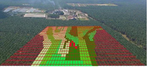
Oil palm planters and farmers would build their own real-time personal remote sensing GIS-ready (Geographic Information System) database documenting fertilizer, nourishing and planting activities details in the software with the use of a crop model to predict the expected yield. LAPERS would feed such an OPPA system with high temporal and high resolution spatial data - hence forth eliminates the dependency on third party data such as rather an out-dated and low-resolution satellite data or expensive airborne IFSAR campaign. Whenever a true and practical Variable Rate Technology (VRT) tool is available for oil palm [14], [15], [16] then LAPERS would function as prime spatial data generator for such tool e.g. precise fertilizer prescription mapping (see Figure-6), real-time harvest tracker etc.
Acknowledgement
Parts of this research work (Author 1) is funded by the UTM Encouragement Grant (EG) VOT 09J93 – 1st April
2014 until 31st March 2015 led by Dr Abd Wahid Rasib
(FGHT UTM Skudai JB).
References
[1] K. Jusoff. 2009. Sustainable Management of a Matured Oil Palm Plantation in UPM Campus, Malaysia Using Airborne Remote Sensing. J. Sustain. Dev. 2(1995): 196-200.
[2] M. B. Wahid, S. Nor, A. Abdullah, and I. E. Henson. 2005. Oil Palm–Achievements and Potential. Plant Prod. Sci. 8: 1-13.
[3] Lukman, F.M., and Z. Poeloengan. 1996. Application of Remote Sensing Technique for Oil Palm Plantation
Management. Proceedings of the 1997 PORIM
International Palm Oil Congress Competitiveness for the
21st Century. 460-467.
[4] Ibrahim, S., Zainal Abidin Hasan and Mariamni Khalid. 2000. Application of Optical Remote Sensing Technology for Oil Palm Management. Proceedings of The 21st Asian
Conference on Remote Sensing. 4-8 December 2000,
Taipei, Taiwan. 3.
[5] McMorrow, J. M. 1995. Relation of Oil Palm Spectral Response to Stand Age. Int. J. Remote Sensing. 16: 3203-3209.
[6] Everaerts, J. 2008. The Use of Unmanned Aerial Vehicles (Uavs) for Remote Sensing and Mapping. The International Archives of the Photogrammetry, Remote Sensing and
Spatial Information Sciences. XXXVII: 1187-1192. Retrieved
at
http://www.isprs.org/proceedings/XXXVII/congress/1_pdf/ 203.pdf.
[7] Cracknell, Arthur Philip, Kasturi Devi Kanniah, Kian Pang Tan, and Lei Wang. 2013. Evaluation of MODIS Gross Primary Productivity and Land Cover Products for the Humid Tropics Using Oil Palm Trees in Peninsular Malaysia and Google Earth Imagery. International Journal of Remote Sensing.
34(20): 7400-7423.
[8] Liaghat, Shohreh, and Siva Kumar Balasundram. 2010. A Review: The Role of Remote Sensing In Precision Agriculture.
American Journal of Agricultural and Biological Sciences.
5(1): 50-55.
[9] Lelong, Camille CD, Jean-Michel Roger, Simon Brégand, Fabrice Dubertret, Mathieu Lanore, Nurul A. Sitorus, Doni A. Raharjo, and Jean-Pierre Caliman. 2010. Evaluation of
Oil-Palm Fungal Disease Infestation with Canopy
Hyperspectral Reflectance Data. Sensors. 10(1): 734-747. [10] Samseemoung, Grianggai, Peeyush Soni, Hemantha PW
Jayasuriya, and Vilas M. Salokhe. 2012. Application of Low Altitude Remote Sensing (LARS) Platform for Monitoring Crop Growth and Weed Infestation in a Soybean Plantation. Precision Agriculture. 13(6): 611-627.
[11] Fairhurst, Thomas, and Rolf Härdter. 2003. Oil Palm:
Management for Large and Sustainable Yields. Potash &
Phosphate Institute.
[12] Cook, S. E., R. O’Brien, R. J. Corner, T. Oberthur, J. Stafford,
and A. Werner. 2003. Is Precision Agriculture Irrelevant to Developing Countries. Precision Agriculture. 115-120.
[13] Stark, Brandon, Calvin Coopmans, and YangQuan Chen.
2013. Concept of Operations for Personal Remote Sensing Unmanned Aerial Systems. Journal of Intelligent & Robotic
Systems. 69(1-4): 5-20.
[14] Ishak, W., R. Hudzari, and M. Ridzuan. 2011. Development of Variable Rate Sprayer for Oil Palm Plantation. Bulletin of
the Polish Academy of Sciences: Technical Sciences. 59(3):
299-302.
[15] Wahid, B. O., A. S. Rahim, A. M. Tarmizi, and M. W. Basri. 2004. Variable Rate Fertilizer Applicator for Oil Palm. MPOB
Information Series.