UAS FOR ARCHAEOLOGY. NEW PERSPECTIVES ON AERIAL DOCUMENTATION
P. Fallavollitaa,c, M. Balsia, S. Espositoa,c, M. G. Melisb, M. Milaneseb, Luca Zappinoc
a
Dept. of Information Engineering, Electronics, and Telecommunications (DIET), “La Sapienza” University, via
Eudossiana 18, 00184 Rome, Italy – (esposito, fallavollita)@diet.uniroma1.it, [email protected]
bDept. of History, Human Sciences and Education, University of Sassari, via Zanfarino, 62, 07100 Sassari, Italy –
(mgmelis, milanese)@uniss.it
c
Oben s.r.l., Private enterprise, 1° Trv. S. Anatolia 36, 07100 Sassari, Italy – [email protected], www.oben.it
KEY WORDS: Archaeology, UAV, UAS, Unmanned Aerial Systems, Ortho-images
ABSTRACT:
In this work some Unmanned Aerial Systems applications are discussed and applied to archaeological sites survey and 3D model reconstructions. Interesting results are shown for three important and different aged sites on north Sardinia (Italy). An easy and simplified procedure has proposed permitting the adoption of multi-rotor aircrafts for daily archaeological survey during excavation and documentation, involving state of art in UAS design, flight control systems, high definition sensor cameras and innovative photogrammetric software tools. Very high quality 3D models results are shown and discussed and how they have been simplified the archaeologist work and decisions.
1. INTRODUCTION
Since many decades and in uncountable fields, aerial ortho-photos have been widely used for large and small-scale survey, documentation and report.
For archaeological survey in the fields of preventive archaeology, cultural heritage planning and preservation, such tools as remote sensing, satellite or short-range image analysis are very useful but still expensive.
On a small scale, in archaeological excavation, the traditional manual documentation is often completed with ortho-images, obtained by cameras mounted on top of telescopic poles (Chiabrando et alii 2010).
Certainly, this procedure is a good improvement with respect to manual documentation, providing faster operations and more precise results.
Nevertheless, such simple setup only allows taking photographs from a few meters height, needs some kind of leveling control system and mosaicking software to produce whole area coverage and reduce distortions.
Until now, aerial remote sensing is mostly operated by manned aircrafts at high cost and subject to restrictions that make its use prohibitive for every-day survey.
Recently, UAS (Unmanned Aerial System) technology in the archaeological field has seen a wider (Rinaudo et alii 2012), though still sporadic, application.
In this work some archaeological application are discussed and interesting results are shown for three sites on north Sardinia (Italy) that have complementary characteristics due to different ages and features.
2. MATERIALS AND METHODS
2.1 UAS solutions
The activity spent in experimental works with UASs has been carried out thanks to the collaboration with the DIET of “La Sapienza” University of Rome and spin-off enterprise Oben srl, operating in UAV design, manufacturing and services, in order
to design and realize each aerial vehicle, making it able to test hardware solutions in real flights and extract data from sensors. The used UAS was specifically designed to carry a relatively heavy Digital Single Lens Reflex (DSLR) camera and its related gimbal.
The choice has fallen upon a one-meter-diameter octo-copter multirotor, with a frame completely made of carbon fiber, driven by four pairs of coaxial electrical engines, permitting a very precise GPS waypoint navigation, auto take-off and landing by its sophisticated autopilot, being able to carry a payload of 4kg, supplied by two LiPo batteries of 5Ah each and guaranteeing 15 minutes cruise-range.
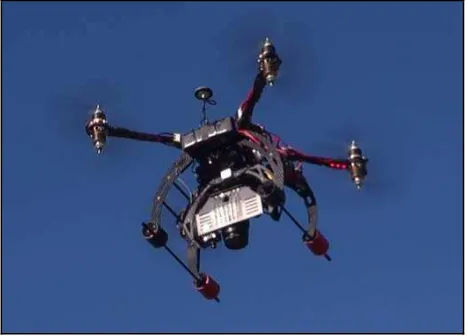
Figure 1. The octo-copter multirotor during a nadir survey
This system is completed by a useful video system composed of a secondary navigation camera mounted on board next to the main sensor, a powerful radio transmitter and receiver and a pair of special goggles equipped with two internal color displays permitting the second operator on ground to a real time control of the captured scenario from on high.
The whole automatic flight is permitted by the autopilot that needs a specific radio-link to the ground control station where the second pilot is always able to command the copter, modify its flight plan or some parameters and view the flight data as altitude, speeds, battery energy status and other considerable information required for safe operations, guaranteeing 15 minutes cruise-range (Figure 1).
2.2 Photogrammetry for 3D accurate modeling
The acquired methodology is based on flight planning, sensors setting-up, images processing, orthophotos or 3D model building and features automatic extraction.
The 3D model, obtained from aerial images pairs based photogrammetry, permits centimeter order resolution quite comparable to the sub-centimeter of a very expensive laser scanner product, but still very useful to understand and document the dynamics of the archaeological deposit formation. The choice of camera sensor that better fit a good pixel resolution and small lens distortion has fallen on a Canon Eos 550D, a digital SLR camera, capable of 18 mega pixel and full manual setup as often requested during aerial survey where autofocus systems fail to work in quick sliding view (i.e. nadir shooting).
A first computation of ground swath and pixel expected size need to be made during flight planning, in order to better design the aerial scanning pattern.
A dedicated software has been designed to permit the automated calculus of above parameters, as sensor size and data, camera focal lens, height of flight and angle of view have been fixed.
As displayed in Figure 2, indicating with feff the camera
effective lens focal,
the half angle of view and l the sensor size, it results:
2 1l
eff tg
f
(1)The ground swath length ls along y axis is:
2 2
s O eff
l h tg
h f tg
(2)where h0 is the distance of lens group to ground and h is the
above ground level (AGL) flight height. Assuming the pixels number Npx along l, it results the pixel size on ground along l is
given by eq. (3):
s x
px
l p
N
(3)
Figure 2. Camera and geometric flight data representation
According to the above mentioned formula, it has been possible to diagram the swat size for along and cross flight direction (Figure 3) and the corresponding pixel dimension on ground (Figure 4). Such kind of data, related to each employed specific camera (i.e. Canon Eos 550D) is very essential for an optimal mission planning.
Figure 3. Ground swath size (m) versus AGL flight height (m)
As the flight plan is completed, according to diagrams suggestion upon survey area extension and requested ground pixel resolution, it has been uploaded into the electronic core of multirotor using the dedicated radiolink, the octocopter starts its completely automated tasks: take off, assigned waypoint following and final landing.
Figure 4. Ground pixel size (cm) versus AGL flight height (m)
During the flight, a custom firmware resident in the camera SD card storage, provides a sequenced trigger to obtain a shoot every each second. This time interval has been revealed optimum for a good overlapping in the flight directions (more than 80%) according to the max horizontal speed set up for autopilot (6 m/s) and a flight level below 100 meters.
For a typical mission, i.e. an hectare area observation, the time of flight is less than 5 minutes and no more than 10 waypoints, so it is very fast and easy process, especially it is affordable for people not skilled in flight UAV control.
As on ground, the whole set of images is loaded into the photogrammetry software to start the process that achieve the 3D model of the flying over area.
The used software (Agisoft PhotoScan Pro) running on a HP Z800 workstation (Hewlett Packard 2013), has been allowed to generate high resolution georeferenced orthophotos and detailed DEMs or textured polygonal models through a fully automated workflow (Agisoft 2013).
Following this simple way, orthophoto images are easily ready for next processing stage, avoiding a rather usual, long and difficult work adopted from archaeologists, using cameras mounted on the top of telescopic poles.
Certainly this automated procedure means a good improvement respect to the manual relief providing faster operations and more precise results in terms of very precise orthogonally and free from aberration or distortion images (Mikhail 2002).
2.3 Three investigated archaeological sites
The first survey here described has been realized over the Usini (Sassari) area where, since many years, a prehistoric research team from the University of Sassari has been conducting interdisciplinary research on a Neolithic necropolis and its surrounding territory (Melis 2010).
The second site here shown has been conducted in the Neolithic shrine of Monte d’Accoddi (Melis 2011).
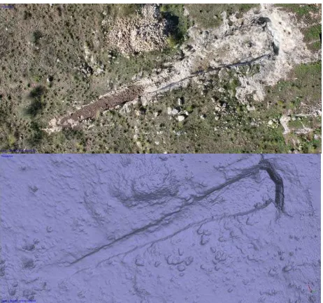
Figure 5. S’Elighe Entosu (Usini, Italy). Neolithic necropolis. Ortho-photo and 3D model of the tomb IV, obtained by aerial images
The third site is managed by the medieval research team of the same University, on a larger area, more than two hectares, near Ozieri (Sassari), where the presence of an old medieval village named Sant’Antioco di Bisarcio, still never excavated, was evidenced by walls of collapsed buildings visible on the surface (Milanese 2012).
The main goal of this work is having demonstrated that, only by relying on small UASs, it is possible to obtain satisfactory results in terms of cost, quality and ease of operation. In particular, this is true for photogrammetry procedures, which provide the most cost-effective and affordable way to do accurate aerial 3D scanning, measurement and image-based modeling.
The 3D model obtained from aerial image pairs permits centimeter-scale resolution, quite comparable to the sub-centimeter of a very expensive laser scanner product, and still very useful to understand and document dynamics and timing of archaeological deposits formation.
During the first mission over Usini, the main target has been a photogrammetric survey of the extremely long corridor of a Neolithic rock-cut tomb (Figure 5).
The corridor, 27 meters long, represents definitely an unicum; during the Bronze Age its floor was covered by some layers of cobbles and stones, made by medium size.
During the first stage of excavations, the survey documentation was done using the traditional methods until then utilized, this means several ortho-images shoot by a cameras mounted on top of telescopic poles. Now, the intensive utilization of this drone has permitted of obtaining images from bigger height, a bigger coverage, with less time and a simpler mosaic setup.
The 3D model, obtained from aerial images pairs based on photogrammetry, comparable to a very expensive laser scanner product, becomes a very useful aid to understand and document the dynamics of the archaeological deposit formation.
The aerial survey above the contiguous area has also concerned a Roman necropolis, distinguished by small cremation pits and burials. After the Roman Age, several tombs were cut by a very large mine. By relying on images captured by UAS and by analyzing grass anomalies, it has now been possible to rapidly determine its bounds and extension, covering an area of about 70 x 30 meters (Figure 6).
Figure 6. S’Elighe Entosu (Usini, Italy). Ortho-photo of the Roman necropolis and post-Roman mine
The second survey here presented has been realized in the famous Neolithic shrine of Monte d’Accoddi (Sassari).
This is a monument of exceptional importance and, without doubts, an unicum in the whole Mediterranean area, for its unusual architecture of truncated pyramid with ramp (m 75 x 37,50). Nevertheless it is still little known from large people, for this reason has been selected as study site to obtain, as more possible, its precise and easy to navigate 3D model.
The unique survey data concerning this important site are only old aerial images or 3D reconstructions based on images captured on ground. The flight mission goal has been pointed to acquire a relevant quantity of aerial high resolution images,
from different camera orientation, in order to permit the best 3D model realization (Figure 7).
Figure 7. Monte d’Accoddi (Sassari, Italy). 3D model (texture and mesh) of the prehistoric shrine, obtained by aerial images.
The third aerial survey test has been instead acted over the Sant’Antioco di Bisarcio area. The site of the Bisarcio (Ozieri, SS) is a place particularly rich of meaning for the study of Medieval Sardinia, being the seat of a diocesis and an important village, at least from the eighties of the eleventh century to the sixteenth century.
The archaeological research strategy has been developed in the two cores of the settlement, the episcopal area, with the basilica of Sant 'Antioco Bisarcio and surroundings and a second area interpreted as a large village.
The area where there are the remains of the village of Bisarcio is a pasture, characterized by piles of stones and a morphology of the ground altogether irregular, due to smoothing of the outcrop and fragments of walls. It was therefore possible to identify - with a survey of a very high intensity - the remains of more than 120 buildings, which has been detected in their dimensions.
A plan of the village that allows us to understand its urban planning, roads, the hosts of buildings, both public and private spaces, the church, the cemetery likely, the relationship with the Episcopal area has been outlined. Using the drone in Bisarcio was particularly useful, both on the topographic plan to obtain high definition 3D ortho-photos as a tool for comparison and integration of the information from the direct relief and survey of the ground.
This result was obtained with low costs and time, also for the good preservation of the site. The drone was tested with excellent results during the excavation of the site, during which it was evident the saving of working time, and costs.
The quality of the results in the relief of the mounds of stones outcoming of the processes of spoil of the site, seems a very interesting element of the systematic application of this technology to the stratigraphic excavation procedures.
Acquiring a significant number of high resolution zenith aerial images (18 megapixels) by UAS, and making a real 3D photogrammetric ortho-photo of the whole area (Figure 8), it
was possible to enhance an impressive number of geometric grass and soil color anomalies or very little buried structures, leading the archaeologist to highlight shapes, walls lines, rooms and streets of the old village.
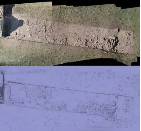
Figure 8. Bisarcio area, true orthophoto derived from 3D terrain model.
This approach has easily provided archaeologists with the probable map of the village only relying on aerial views. These results will form the basis to operate, in targeted way, the next excavations. More detailed flights and surveys have been lead over some specialized areas where archaeologists were working on, providing daily models and documenting the regular progress of excavation (Figure 9).
Figure 9. Bisarcio area 5300, true orthophoto from 3D model (texture and mesh)
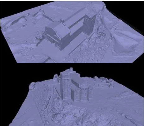
During this stage a detailed survey of the near medieval Bisarcio’s church has been also carried out (Figure 10).
This mission, flying from an altitude of 150m AGL, has permitted a good survey of the church and the whole hill.
Figure 10. The Bisarcio church and hill, 3D meshed models
3. CONCLUSIONS
In this works, the methodology applied was based on flight planning, sensors setup, image processing and ortho-photo or 3D-model building. Innovative data exploitation is also being developed, with the purpose of easily and automatically extracting and highlighting salient features to aid archaeologist in their analysis of the survey results, as happened for the Bisarcio survey.
State-of-the-art image processing and data fusion techniques are going to be combined with machine learning and fuzzy logic algorithms.
Results obtained in the already reported first survey campaign, confirm the stipulated advantages of UAS-based surveying in terms of very low costs, rapid data acquisition, easy operation, high-resolution documentation and well geo-referenced maps and models.
4. REFERENCES
Agisoft website, http://www.agisoft.ru (April 2012).
Chiabrando, F., Costamagna, E., Rinaudo, F., Spanò, A., 2010. Very close nadiral images: a proposal for quick digging survey.
The International Archives of Photogrammetry, Remote Sensing and Spatial Information Sciences, Vol. XXXVIII/5, pp.
155-160.
Hewlett Packard website, http://www.hp.com (April 2012).
Melis, M. G., 2010 (ed). Usini. Ricostruire il passato. Una
ricerca internazionale a S’Elighe Entosu, Carlo Delfino
Editore, Sassari, Italy.
Melis, M. G., 2011. Monte d’Accoddi and the end of the Neolithic in Sardinia (Italy), Documenta Praehistorica XXXVIII, pp. 207-219.
http://arheologija.ff.uni-lj.si/documenta/v38.html
Mikhail, E. M., Bethel, J., McGlone, C., 2001, Introduction to
Modern Photogrammetry, John Wiley & Sons Publishers.
Milanese, M., 2012 (Bisarcio)
http://www.fastionline.org/micro_view.php?fst_cd=AIAC_302 1&curcol=sea_cd-AIAC_4578 (April 2012)
Oben website, http://www.oben.it (April 2012).
Rinaudo, F., Chiabrando, F., Lingua, A., Spanò, A.T., 2012. Archaeological site monitoring: UAV photogrammetry can be an answer, The International archives of the photogrammetry,
Remote sensing and spatial information sciences, ISPRS
Council, Vol. XXXIX n. B5, 583-588.