© 2016 Universitas Negeri Semarang
RISIKO BENCANA DI KABUPATEN PEKALONGAN (DISASTER RISK IN PEKALONGAN REGENCY)
Ananto Aji1, Wahid Akhsin Budi Nur Sidiq1, Satya Budi Nugraha1, Dewi Liesnoor Setyowati1, Nana Kariada Tri Martuti2
Lecturer of Geography Department of the Faculty of Social Sciences, UNNES1 and Lecturer of Biology of the Faculty of Mathematics and Sciences, UNNES2
Email: ajiananto@yahoo.com Sejarah Artikel Diterima: Maret 2016 Disetujui: April 2016 Dipublikasikan: Juli 2016 Abstract
Pekalongan Regency of Central Java is a region with high risk of disaster. Various kinds of disaster such as landslide, flood, drought, and tidal flood have somehow become “seasonal customer” for occurring in Pekalongan Regency. This research aimed to prepare the mapping of disaster risk in order to strengthen the efforts in reducing disaster risk in Pekalongan Regency. The research method applied in this research refers to the Head’s Regulation of National Risk Management Agency Number 2/2012. Since the risks of tidal flood were not yet included in the regulation, the field observation approach was used in this research. The analysis of disaster risk also considered the collecting method of disaster history by organizing focus group discussion (FGD) with the related parties. The research result showed that there were high risks of flood disaster covered some sub-districts such as Kajen, Kesesi, Wonopringgo, Karangdadap, Tirto, Wiradesa and Wonokerto; there were twenty six villages in total. High risk of landslide potentially occurred in large part of villages on the south area of Pekalongan Regency. High risk of drought was relatively evenly spread in the center area. Lastly, high risk of tidal flood potentially occurred in fifteen villages along side of Java Sea.
Keyword: Pekalongan regency, risk, disaster
Abstrak
Kabupaten Pekalongan – Jawa Tengah merupakan wilayah yang memiliki risiko tinggi terhadap kejadian bencana. Beberapa jenis bencana sudah menjadi “langganan” terjadi di wilayah Kabupaten Pekalongan, seperti tanah longsor, banjir, kekeringan, dan rob. Tujuan penelitian ini adalah menyiapkan peta risiko bencana untuk memperkuat upaya pengurangan risiko bencana di Kabupaten Pekalongan. Metode penelitian yang diterapkan mengacu pada Perka BNPB Nomor 2 tahun 2012. Khusus untuk risiko bencana rob, mengingat belum termaktub di dalam Perka, maka digunakan pendekatan observasi lapangan. Analisis risiko bencana mempertimbangkan proses penjaringan sejarah bencana melalui focus group discussion (FGD) yang melibatkan para pihak terkait. Hasil penelitian menunjukkan bahwa risiko bencana banjir tinggi meliputi Kecamatan Kajen, Kesesi, Wonopringgo, Karangdadap, Tirto, Wirodesa dan wonokerto; dengan jumlah keseluruhan 26 desa. Risiko bencana longsor tinggi berpotensi terjadi di sebagian besar desa di wilayah selatan. Risiko bencana kekeringan tinggi relatif merata di bagian tengah Kabupaten Pekalongan. Adapun risiko bencana rob tinggi berpotensi terjadi di 15 desa di dekat pantai Laut Jawa.
Kata Kunci: peta jalur evakuasi bencana banjir, kesiapsiagaan, stakeholder
Jurnal Geografi
Media Infromasi Pengembangan Ilmu dan
Profesi Kegeografian
© 2016 Universitas Negeri Semarang
1. Research Background
Indonesia is naturally a region with high level of disaster vulnerability. Indonesia is also in the Pacific ring of fire and is located in the middle of three active earth tectonic plates. This positions Indonesia of having high threat of natural disasters such as volcanic eruption, earthquake, tsunami, and landslide. Moreover, as Indonesia has tropical climate with two seasons and is located in the archipelago, it is prone to the natural consequences for the threat of flood, tidal flood, landslide, wildfire, abrasion, and extreme weather, and disease outbreaks (Koehatman, 2010).
According to the Law No 24 of 2007 on the Implementation of Disaster Management
(Undang-undang Nomor 24 Tahun 2007
tentang Penyelenggaraan Penanggulangan Bencana), disaster is an occurrence or a set of occurrences that threaten and disrupt life and society’s livelihood, which is caused by natural and/or non-natural factors or human factors, resulting in the loss of human lives, environmental damage, loss of property, and psychological impacts (Bakornas PB, 2007). United Nation - International Strategy for Disaster Reduction (in Nurjanah, et al., 2011) also provides another definition for disaster as:
“a serious disruption of the functioning of a community or a society causing widespread human, material, economy or environmental loss which exceed the ability of the affected
community/society to cope using its own resources”.
The development of paradigm of disaster management has shifted from disaster management to disaster risk management (ISDN, 2005 in Purnomo, 2013). Furthermore, Purnomo (2013) states that in the paradigm of reducing disaster risk, negative impacts of certain disasters could be reduced if the society understands the characteristics of regions that are prone to disaster, understand the objects that are vulnerable to hazard, and understand individual or society’s capacity in dealing with disasters.
The study of disaster risk under the framework of disaster management in Indonesia has quite diverse translation. The Head’s Regulation of National Risk Management Agency Number 2 of 2012 on the General Guidelines for Disaster Risk Studies
(Peraturan Kepala BNPB Nomor 2 tahun 2012
tentang Pedoman Umum Pengkajian Risiko
Bencana) provides certain limitation that the
study of disaster risk is a tool to determine the possibility and the amount of loss due to the existing disaster threat. Furthermore on its definition, the study of disaster risk is an integrated mechanism to provide holistic view of the disaster risk in a region by analyzing the degree of threat, degree of loss, and the region’s capacity. The scope of the study of disaster risk includes the study of degree of
disaster risk, the study of vulnerability level, the study of capacity level, and the study of risk level (BNPB, 2012).
The type of disaster in a region will differ from another region, depending on the condition and physical feature of the region. Pekalongan Regency (Kabupaten Pekalongan) as one of regencies in Central Java is a particular region that has high risk of disaster occurrences. This is because Pekalongan Regency has corrugated morphology in the southern part and lowland in the northern part. In terms of climate, the southern part tends to have high rainfall, even reaching more than 6,000 mm/year (BPS Kabupaten Pekalongan, 2013). Based on the interview conducted with BPBD Kabupaten Pekalongan, it was recorded that high rainfall in the southern areas often triggered landslide and flash flood in the northern part. In 2013, there were 79 cases of landslide and 16 cases of flood. Specifically in Kecamatan Tirto, some villages also suffered from tidal flood routinely. On the contrary, on dry season, some sub-districts (Kecamatan) in Pekalongan Regency also suffered from drought (BPBD Kabupaten Pekalongan, 2014).
Based on the explanation on the research background, this research aimed to perform comprehensive assessment on the risk of disaster in order to strengthen the efforts of
reducing disaster risk, which would involve some stakeholders in Pekalongan Regency.
2. Research Methods
Principally, the calculation of disaster risk refers to the guidelines included in the Head’s Regulation of National Risk Management Agency Number 2 of 2012 on the General Guidelines for Disaster Risk Studies
(Peraturan Kepala BNPB Nomor 2 tahun 2012
tentang Pedoman Umum Pengkajian Risiko
Bencana) (BNPB, 2012). However, besides the
analysis result, it is also important to include the process of acquiring more data on the history of disaster by conducting focus group discussion (FGD) that involved some related parties from the research areas (Chambers, 1996).
The study of disaster risk is considered as an approach to present the potential of negative impacts that might occur after a potential disaster that occurs. The occurring potential of negative impacts is calculated based on vulnerability and capacity levels on a particular region. The potential of negative impacts are seen through the potential of the exposed population to the disaster, the loss of property, and environmental damage. Generally, the calculation of disaster risk is conducted by applying the following formula (BNPB, 2012):
© 2016 Universitas Negeri Semarang Based on the above approach, it could be
seen that the degree of disaster risk is highly influenced by the level of threat, vulnerability, and capacity. Basically, the effort in studying the disaster risk is to determine the magnitude of three components of risks and to present them in spatial or non-spatial form to make
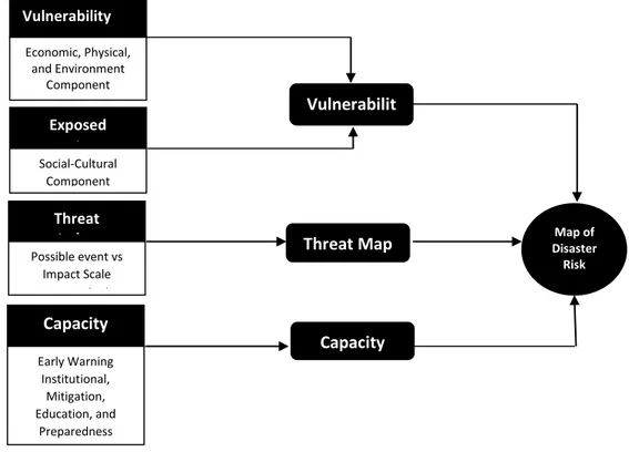
them more easily understood. Therefore, the efforts in managing disaster risks are in the form of: 1) reducing threat; 2) lessening vulnerability; and 3) improving capacity. The following figure presents the chart showing the method of disaster risk mapping (Figure 1).
Figure 1. Method of Disaster Risk Mapping
(Source: Head’s Regulation of National Risk Management Agency Number 2 of 2012)
2.1 Vulnerability Index
Vulnerability is a set of conditions and/or a result of circumstances (physical, social, economic, and environmental factors) which has negative impacts on the efforts of preventing and managing disaster (BNPB, 2012). Vulnerability has strong relation with individual or community’s ability to deal with
threat. Based on the Head’s Regulation
(Perka), the study of vulnerability could be
divided into four parts; they are social vulnerability, economic vulnerability, physical vulnerability and ecological vulnerability.
2.2 Threat Index
Threat of disaster is a physical phenomenon or human’s activities that have Capacity Index Early Warning Institutional, Mitigation, Education, and Preparedness Component Vulnerabilit y Map Threat Map Capacity Map Map of Disaster Risk Vulnerability Index Economic, Physical, and Environment Component Exposed Population Social-Cultural Component Threat Index Possible event vs Impact Scale Recorded
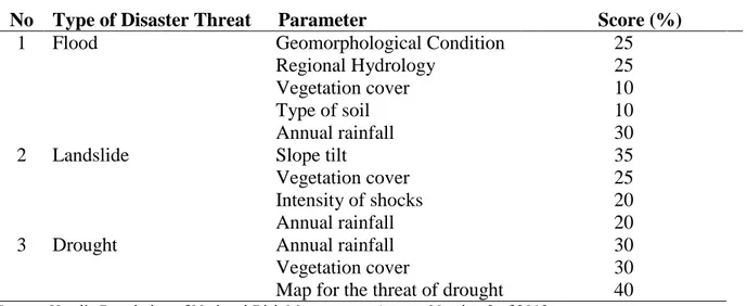
the potential in causing the loss of life, damage to property, social and economic disruptions or environmental damage (BNPB, 2012). Based on the studies of the disaster occurrence data in Pekalongan Regency, it showed that there were some natural disasters that often threatened the regions such as flood, landslide, drought, and tidal flood. The assessment of disaster risk was conducted by studying the factors influencing
the occurrence of those disasters (Table 1). Specifically for the threat of tidal flood, the determination of inundation spread was performed by field measurements on the highest tide because the method to calculate tidal inundation has not been arranged in the Head’s Regulation of National Risk Management Agency Number 2 of 2012
(Perka BNPB Nomor 2 Tahun 2012).
Table 1. Factors Influencing the Threat of Disaster
No Type of Disaster Threat Parameter Score (%)
1 Flood Geomorphological Condition
Regional Hydrology Vegetation cover Type of soil Annual rainfall 25 25 10 10 30
2 Landslide Slope tilt
Vegetation cover Intensity of shocks Annual rainfall 35 25 20 20
3 Drought Annual rainfall
Vegetation cover
Map for the threat of drought
30 30 40 Source: Head’s Regulation of National Risk Management Agency Number 2 of 2012
2.3 Capacity Index
Capacity is the ability of an individual or group of people in dealing with the danger or threat of a disaster. There are some aspects of ability such as policy, preparedness, and society’s participation. The assessment of ability is conducted on human resources of an individual, a household, or a group in dealing with a threat and in surviving the impacts of a disaster threat. The assessment is conducted based on the aspects of policy, preparedness,
and the society’s participation. The indicators that are used for the assessment of capacity include: a) rules and institutions of disaster management; b) early warning and the studies of disaster risks; c) education on disaster; d) reduction of basic risk factors; and e) the development of preparedness in all levels.
© 2016 Universitas Negeri Semarang
3. RESULTS AND DISCUSSION
3.1 History of Disaster Occurrence in Pekalongan Regency
The problems of natural disaster occurring in Pekalongan Regency are considered as highly concerning. BPBD Kabupaten Pekalongan (2014) informs that in Pekalongan Regency, there were 91 cases of
natural disaster in 2007 and increased to 262 cases in 2011. In 2013, there were 79 cases of landslide and 16 cases of flood. In dry season, some sub-districts in Pekalongan Regency often suffered from drought. Especially for Kecamatan Tirto, some villages even suffered from regular cases of tidal flood.
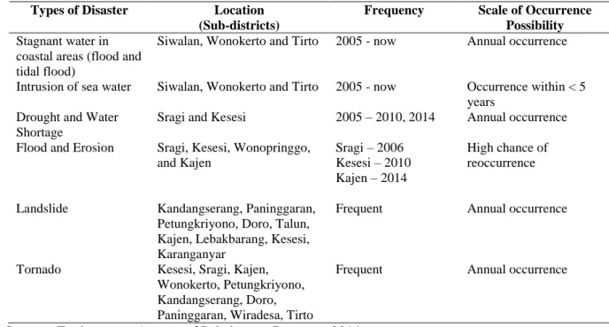
Table 2. History of Disaster Occurrence in Pekalongan Regency
Types of Disaster Location (Sub-districts)
Frequency Scale of Occurrence Possibility Stagnant water in
coastal areas (flood and tidal flood)
Siwalan, Wonokerto and Tirto 2005 - now Annual occurrence
Intrusion of sea water Siwalan, Wonokerto and Tirto 2005 - now Occurrence within < 5 years
Drought and Water Shortage
Sragi and Kesesi 2005 – 2010, 2014 Annual occurrence Flood and Erosion Sragi, Kesesi, Wonopringgo,
and Kajen Sragi – 2006 Kesesi – 2010 Kajen – 2014 High chance of reoccurrence
Landslide Kandangserang, Paninggaran, Petungkriyono, Doro, Talun, Kajen, Lebakbarang, Kesesi, Karanganyar
Frequent Annual occurrence
Tornado Kesesi, Sragi, Kajen, Wonokerto, Petungkriyono, Kandangserang, Doro, Paninggaran, Wiradesa, Tirto
Frequent Annual occurrence
Source: Environment Agency of Pekalongan Regency, 2014
Based on the information presented in Table 2, it was found that the areas in Pekalongan Regency were considered prone to natural disaster. Landslide often occurred in the southern part with special characteristics of undulating topography with steep contours and high rainfall. High rainfall in the southern part also caused high river flow debit that flows to the Java Sea; therefore, causing flood in the northern part, which was dominated with flat
grounds (in some areas tended to be concave). The negative impacts of flood would be harder for the people because at the same time, tidal flood also occurred in the northern part, which obstructed river flow to the sea. Furthermore, drought and tornado were also prone to occur in some sub-districts of Pekalongan Regency.
When the authors conducted the focus group discussion (FGD) with the government officials of all sub-districts in Pekalongan
Regency on 23 December 2014, it was recorded that landslide, flood, and tidal flood were the dominant disasters that had been frequently occurring in Pekalongan Regency.
Table 3 presented the summary of FGD results of the history of disaster in Pekalongan Regency.
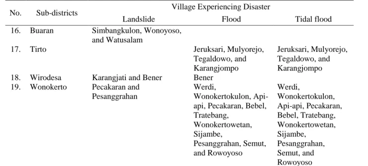
Table 3. Sub-districts and Villages with High Potential of Disaster Occurrence
No. Sub-districts Village Experiencing Disaster
Landslide Flood Tidal flood 1. Kandangserang Klesem, Bodas, Luragung,
Bojongkoneng,
Wangkelang, Gembong, Trajumas, Sukoharjo, Tajur, Karanggondang,
Garungwiyono, and Kandangserang
2. Paninggaran Bedagung, Paninggaran, Winduaji, Krandegan, Botosari, Lumeneng, Werdi, and Notogiwang
3. Lebakbarang Wonosido, Timbangsari, Kutorembet,
Tembelanggunung, Depok, Bantarkulon, and Mendolo 4. Petungkriono Songgodadi, Tlogopakis,
Simego, Curugmuncar, Tlogohendro, Kasimpar, Yosorejo, and Kayupuring 5. Talun Jolotigo, Sengare, and
Mesoyi 6. Doro Pungangan
7. Karanganyar Lolong, Gutomo, and Pedawang
8. Kajen Linggoasri, Brengkolang, and Kutorojo Kutorejo, Pekiringanalit, Sangkanjoyo, Sabarwangi, and Wonorejo 9. Kesesi Ujungnegoro, Sukorejo,
Windurojo, Srinahan, and Kesesi Watugajah, Jagung, and Langensari 10. Sragi 11. Siwalan 12. Bojong
13. Wonopringgo Galangpengapon Galangpengapon 14. Kedungwuni Rengas and Kedungwuni
Barat
15. Karangdadap Kaligawe, Pangkah, Kalilembu, Karangdadap, and Kebonsari
© 2016 Universitas Negeri Semarang
No. Sub-districts Village Experiencing Disaster
Landslide Flood Tidal flood 16. Buaran Simbangkulon, Wonoyoso,
and Watusalam
17. Tirto Jeruksari, Mulyorejo, Tegaldowo, and Karangjompo
Jeruksari, Mulyorejo, Tegaldowo, and Karangjompo 18. Wirodesa Karangjati and Bener Bener
19. Wonokerto Pecakaran and Pesanggrahan
Werdi,
Wonokertokulon, Api-api, Pecakaran, Bebel, Tratebang, Wonokertowetan, Sijambe, Pesanggrahan, Semut, and Rowoyoso Werdi, Wonokertokulon, Api-api, Pecakaran, Bebel, Tratebang, Wonokertowetan, Sijambe, Pesanggrahan, Semut, and Rowoyoso Source: Research Analysis and Result of FGD, 2014
3.2 Disaster Risks in Pekalongan Regency
The determination of disaster risk was acquired from the calculation of threat level, the level of vulnerability, and the capacity level of disaster in the areas of Pekalongan Regency; and by putting the results of the conducted FDG into consideration.
a. Risk of Flood
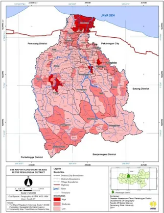
Figure 2 displayed the calculation result of flood disaster risk index in Pekalongan Regency for village or kelurahan analysis unit. High risk of flood was found in Kecamatan Kajen (Desa Kutorejo, Pekiringanalit, Sangkanjoyo, Sabarwangi, and Wonorejo), Kecamatan Kesesi (Desa Watugajah, Jagung, and Langensari), Kecamatan Wonopringgo (Desa Gelangpengapon), Kecamatan Karangdadap (Desa Jrebengkembang), Kecamatan Tirto (Desa Jeruksari, Mulyorejo, Tegaldowo, and Karangjompo), Kecamatan
Wirodesa (Desa Bener), and Kecamatan Wonokerto (Werdi, Wonokertokulon, Api-api, Pecakaran, Bebel, Tratebang, Wonokertowetan, Sijambe, Pesanggrahan, Semut, and Rowoyoso). Furthermore, especially for the flood occurring in 16 villages on three sub-districts (Tirto, Wirodesa and Wonokerto) was the accumulation of flood coming from the southern side and was also caused by the tidal rob that routinely engulfed the north part of Pekalongan Regency. The occurrence of tidal rob caused the seawater to flood the river estuary, therefore, it hindered the river flow to the Java Sea.
b. Risk of Landslide
The calculation result of the landslide disaster risk in Pekalongan Regency for village
or kelurahan analysis unit was presented on
Figure 3. Most of the villages in the south side had high risk of landslide disaster. This was
mainly caused by the fact that the morphology in the south side was dominated with undulating hills and high rainfall.
Landslide is the most common disaster to occur in the south side of Pekalongan Regency. In some cases, landslide in Pekalongan Regency even resulted in casualties. Among the southern sub-districts with high risk of landslide, Kecamatan Kandangserang had the highest risk of landslide. This was mainly because the range of hills in Kecamatan Kandangserang merges with the range of hills in Kecamatan Karangkobar of Banjarnegara Regency.
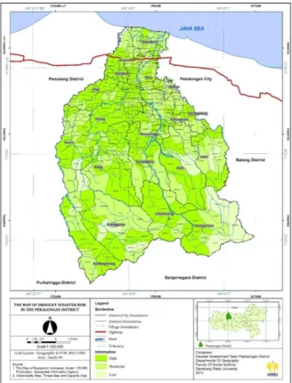
c. Risk of Drought
The calculation result of the drought disaster risk index in Pekalongan Regency for village or kelurahan analysis unit was displayed on Figure 4. The spread of villages with the potential of drought was relatively evenly spread in all regions in Pekalongan Regency, especially in the center area. This
was actually ironic remembering that with high rainfall in the area, the land should have been able to store rain water in large quantity. However, in fact, most of the rainfall turned into run off and flowed into the river or creek.
d. Risk of Tidal Flood
The determination of tidal flood risks is actually not yet included in the Head’s Regulation of National Risk Management Agency Number 2/2012 (Peraturan Kepala
BNPB Nomor 2 Tahun 2012). Therefore, the
regional government often encountered some obstacles in organizing disaster risk alleviation programs. Figure 5 presented the map of tidal flood disaster risk in Pekalongan regency. The spread of tidal inundation was quite evenly in the north part of Pekalongan regency, even, tidal flood had started to spread until some kilometers in the south side, especially in some locations on the river banks that are mostly flat or concave areas, and is still affected by tidal currents.
© 2016 Universitas Negeri Semarang Figure 2. The Map of Flood Disaster Risk
Figure 4. The Map of Drought Disaster Risk
© 2016 Universitas Negeri Semarang
4. CONCLUSION
Based on the research result conducted, it was identified that Pekalongan Regency had significantly high disaster risk. There were some disaster risks that would need thorough attention such as landslide, flood, drought, and tidal flood. The research had successfully created a map of disaster risk for the four types of disasters by each village (kelurahan) analysis unit.
The creation of map for disaster risk was expected to be beneficial for some related parties. Therefore, the programs of disaster management and alleviation could be more organized and right on the proper targets. The regency government and the local society should have done some adaptation and mitigation actions on the occurring disaster risks; hence, they would be able to minimalize the loss that might occur due to disasters.
5. REFERENCES
BAKORNAS PB. 2007. Undang-undang Republik Indonesia Nomor 24 Tahun
2007 tentang Penanggulangan Bencana.
Jakarta: BAKORNAS PB.
BLH Kabupaten Pekalongan. 2014. Status
Lingkungan Hidup Daerah.
BNPB. 2012. Peraturan Kepala BNPB Nomor 2 Tahun 2012 tentang Pedoman Umum
Pengkajian Risiko Bencana. Jakarta.
BPBD Kabupaten Pekalongan. 2014. Data
Kejadian Bencana di Kabupaten
Pekalongan.
BPS Kabupaten Pekalongan. 2013. Kabupaten
Pekalongan dalam Angka.
Chambers, Robert. 1996. PRA (Participatory
Rural Appraisal), Memahami Desa
Secara Partisipatif. Yogyakarta: Penerbit
Kanisius.
Kodoatie, Robert J and Sjarief, Roesta. 2008. Pengelolaan Sumber Daya Air.
Yogyakarta: Andi.
Nurjanah, R. Sugiharto, Kuswanda Dede, Siswanto BP, Adikoesoemos. 2011.
Manajemen Bencana. Jakarta: Alfabeta.
Purnomo, Nugroho Hari, Sutikno, Sunarto, and Lutfi Muta’ali. 2013. Risiko Longsor Lahan pada Lahan Pertanian di Kompleks Gunungapi Kuarter Arjuno Jawa Timur. Jurnal Forum Geografi Volume 27, Nomor 1, Juli 2013. Surakarta: Fakultas Ilmu Geografi UMS. Ramli, Koehatman. 2010. Pedoman Praktis
Manajemen Bencana. Jakarta: Dian
Rakyat.
Tjokronegoro, et al., 2009. Mengelola Risiko Bencana di Negara Maritim Indonesia (Gestion du risque des catastrophes en
Indonésie). Zen, M.T (editor). Bandung.