Sustainable and Contextual
Utilization of Underground River in the Arid Area
Waterman Sulistyana Bargawa
[email protected]Master of Mining Engineering, UPN “Veteran” Yogyakarta, 55283 SWK 104 Yogyakarta, Indonesia
Abstract Many people live in dry areas, therefore clean water is a major issue. The problems is how to choose
the method to find the groundwater river flows, to design a production well installation, to determine the feasibility, and to manage the sustainable and contextual water use according to the community need. Analysis of the results of geological mapping, topography, geophysical measurements, drilling, pipeline and electrical survey, and pumping tests produce the feasibility of the water utilization. The involvement of all stakeholders produce the sustainable and contextual management of clean water use. Research in dry prone areas of Banyutowo, Wonogiri regency Indonesia resulted in the feasibility of a source of clean water for approximately 2,711 people living in the arid region.
Keywords: underground river, arid area, clean water, karst.
Abstrak Banyak orang tinggal di daerah kering sehingga air bersih merupakan isu utama. Permasalahan yang dijumpai adalah bagaimana memilih metode untuk mencari aliran sungai airtanah, merancang instalasi sumur produksi, menentukan kelayakan, dan mengelola penggunaan air yang berkelanjutan dan kontektual sesuai kebutuhan masyarakat. Analisis hasil pemetaan geologi, topografi, pengukuran geofisika, pemboran, survei jaringan pipa dan listrik, dan dilanjutkan tes pemompaan menghasilkan kelayakan pemanfaatan air. Keterlibatan semua stakeholders menghasilkan pengelolaan pemanfaatan air bersih yang berkelanjutan dan kontekstual. Penelitian di daerah rawan kering Banyutowo, Kabupaten Wonogiri Indonesia menghasilkan kelayakan sumber air bersih bagi sekitar 2.711 penduduk yang tinggal di wilayah gersang tersebut.
Kata kunci : sungai bawah tanah, daerah kering, air bersih.
International Conference on Science and Technology 3nd Geomaritime Symposium 2017
1. Introduction
Many people live in arid areas such as the karst region. Generally studies conducted in the karst area is limited to geological studies, for example typical karst geomorphology [1], and study of the development of karst region [2]. Other studies are models of conservation of the karst area [3]. In the dry season people living in arid regions need clean water supplies. Doline ponds have an important role as one of water resources in karst areas, especially during dry seasons [4]. Many studies in the karst area of anticipatory action are providing permanent water supplies [5]. Groundwater from underground rivers is one of the potential raw water sources in the karst area. Research is often conducted to identify hydrogeological conditions as a reference in preparing water source utilization plans in a dry prone area [6]. Research on ground water potential through hydrogeological surveys is used to determine groundwater sources by evaluating geoelectric data to determine the
location of production wells [7]. Utilization of groundwater potential is based on
groundwater quality analysis and
environmental sustainability functions. Pumping test on hydrogeological research is conducted to analyze the potency of groundwater as raw water source[8].
Research to exploit the potential sources of water from underground rivers in karst areas is very important. Utilization of water resources should be based on social and environmental conditions. This case study was conducted in Banyutowo, Wonogiri Regency, Central Java Province Indonesia (Fig.1). The primacy of research in this area is the potential of natural disasters related to geological hazards include: (a) landslides of rock and erosion that potentially occur on the slopes of limestone hill, (b) drought hazard potentially occurs in the southern area of Wonogiri Indonesia.
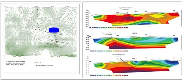
Figure 1: Location of the Research Area in Banyutowo Wonogiri Indonesia
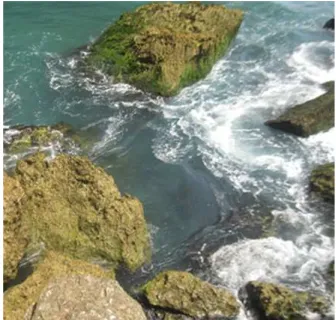
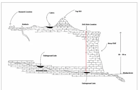
An interesting water potential for this steep coastal area is the emergence of an underground river stream that mixes with seawater, but there is no cave in the area (Fig.2). The difference in elevation is quite large that is about 100m, it makes a problem on the utilization of clean water potential.
The objectives of the study were to analyze (a) hydrogeological conditions, and to plan the season this area is always lack of clean water. The research in the Wonogiri region is important because drought warning has been issued by Indonesian Meteorology Climatology and Geophysics Agency.
The research methodology includes: (a) topographic mapping, surface geology, and underground geology; (b) pipe and electricity network and distribution survey; (c) geoelectric survey; (d) drilling and logging; (e) construction of well; (f) pumping test; (g) analysis of water samples; (h) social and community conditions, morphology and geological hazards.
Geoelectric method for analyzing groundwater potential using resistivitymeter with configuration of Wenner-Schlumberger. And the determination of drilling location is based on the interpretation of field geology data and geoelectric measurement data. The purpose of logging is to determine the physical quantities of the rock based on the physical properties of the rock.
Construction of well includes the installation of casing and screen pipe in accordance with the design of the production well construction.
Well construction planning is carried out to a depth of 90m. The water from the well flows into the tubs and then flows to the surrounding community. The purpose of this pumping test is to examine the condition of underground river flow and deep well type capacity, so that it can be determined the type and capacity of the pump to be installed. Groundwater quality tests include temperature, pH, and electrical conductivity, while laboratory tests include physical, chemical, and metal content to ensure that water quality is safely consumed by the community.
Important aspect in this research is calculation of diameter and length of pipe, flow velocity, selection and calculation of pump. The pump is expected to generate optimum debit with maximum efficiency.
Pipe diameter and flow velocity are important factors in the pumping system. The discussion below follows the equation given by [9]. Calculation of two parameters using the equation:
Di = 3.9 x Q0.45 x ρ0.13, where
Di : pipe inner diameter, mm or inch
Q : capacity/debit, m3/hr or liter/min,
ρ : density of fluid, kg/m3
Calculation of fluid flow velocity: V = Q/A, where
V : fluid flow velocity, m/sec
Q : debit /capacity, m3/hr or liter/min
A : surface area, m2
Other aspects considered are (a) the total head includes the pump's static head, the head loss on the pipe, the friction loss, and the shock loss, (b) the velocity head arising from the speed of the water flow in the pipe, both suction and discharge.
Calculation of high-pressure static head using the formula:
hs = t2 - t1, where:
hs : high press static pump
t2 : water elevation in the outlet
t1 : water elevation in the suction pipe
HF = HL x Lpipe
Hfpipe : pipe friction loss, m Lpipe : pipe length, m HL : pipe head loss, m Q : pump debit, liter/sec
d : pipe inner diameter, mm or inch C : Hazen William’sconstant
The total pump head is the sum of all head loss and is expressed in the formula:
Ht = hs + hv + Hf + Hfs
Calculation of pump power using formula: Pp = 1.02 x Q x Ht x SG x Ef surveys are needed to determine the potential state of power distribution that is useful to assist the design process of utilizing the Banyutowo water source.
Social and community environmental surveys are needed to identify demographic data of Banyutowo, Wonogiri regency such as population, occupation, culture, and community environment. Social and account the rules and norms of environmental sustainability.
Based on studies conducted by [11] involving women in the development process from the research area is included in the geological unit of karst hillside environment. This unit forms a coarse rough morphology, and a steep slope. Limestone in this morphology is formed of karst natural phenomena. The process of dissolving limestone causes the cavity within the limestone. The formation of cavities is the initial process of forming the underground river basin. The underground river stream eventually emerges as a spring, and empties into the Indian Ocean.
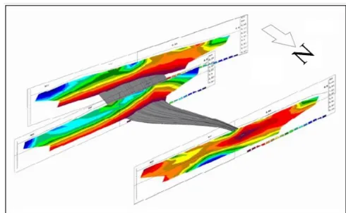
Geoelectric data indicates there is a saturated zone (aqueous cavity) at a depth of about 70-90m from the surface (Fig.3). Implementation of drilling activities with a depth of 90m is based on the geoelectric data. In drilling activities, the water indicated to rise at a depth of 68m and the estimated depth of the base of the underground river is 83m. Based on underground river research, water flows from north to south (Fig.4). Water enters karst
Figure 4. Underground River Modeling Using Hydrogeology Software
Well construction is implemented by using a 83m PVC pipe and a 15m screen length. Based on the test results, groundwater table was found at depth of 68m (28m a.s.l). Based on drilling results (Fig.5), the saturation zone thickness is 15m, and the lowest saturation zone is at 83m (13m a.s.l). The pumping test results show a 3m groundwater level decrease, then the submersible pump installation is carried out at a depth of 74m (22m a.s.l).
The data recorded in the pumping test are (a) preliminary groundwater level (pizometric baseline), (b) pumping flow, (c) groundwater advance during draw-down, (d) time of pumping start, E) time after the pump is turned off. Based on the results of the pumping test, the groundwater level remains stable even though it has been pumped with a maximum discharge of 5 liters/sec.
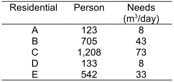
The total population in the research area is 2,711 people (Table 1). If the water debit is 5 liters/ sec, while the assumption of the pump's working time is 10 hr/day, the water produced is 180,000 liters/day. If the water requirement is assumed to be 60 liters/day/person (Regulation of the Minister of Home Affairs No. 23 of 2006), then about 3,000 people can use clean water. Utilization of water from underground rivers can overcome the problem of water shortage in arid area such as in Banyutowo Wonogiri Indonesia.
Based on the elevation difference from topographic mapping results, the number of booster pumps can be calculated. The total length of the pipeline is 5,544m. This pipe network is divided into 12 segments that require 4 booster pumps; in other areas the water flow uses the force of gravity. Based on the results of the lane survey, and field data analysis for the Banyutowo water source utilization plan requires the addition of new power lines. Planning for distribution of electricity network is medium voltage network (MVN) and low voltage network (LVN). The total length of the medium voltage network is 2,080m and the total length of the low-voltage network is 210m.
Figure 5. Well construction using submersible pump
Tabel 1. Water needs per settlement per day
Residential Person Needs
(m3/day)
A 123 8
B 705 43
C 1,208 73
D 133 8
E 542 33
Actually in the research area, there is a lokva (the small karts lake situated in limestone area), but the water quality is very bad. Infrastructure and drinking water facilities can not be utilized optimally. The lack of community involvement in planning, construction, operation and maintenance activities resulted in unoptimal water utilization. In addition, the uncontextual choice of technology makes it difficult for people to determine the infrastructure and facilities according to the needs, local culture, the ability of communities to manage infrastructure and local physical conditions. Lack of community involvement also makes the infrastructure and facilities of drinking water unsustainable, unable to function properly, as well as the lack of public attention to maintain the sustainability of infrastructure and facilities.
Investments in infrastructure and facilities for drinking water and environmental sanitation which have been supply-driven oriented, have had an impact on the low effectiveness of existing infrastructure and facilities. The change of management paradigm in this research is focused on the management of facilities and infrastructure. This management involves the whole society of users. Involvement in decision making results in
Figure 6. The existence of a source of clean water from underground river
Contextual management is the highest decision making of all aspects related to drinking water and or environmental sanitation. The water management is from early stages of identification of drinking water needs, technical planning, and development implementation.
In the research area the role of women is very dominant to meet the needs of drinking water and environmental sanitation. As a party related to the utilization of drinking water and sanitation infrastructure, women are more aware of what they need in terms of access to water and ease of use of infrastructure and facilities. In this study women are the main roles in the development of drinking water and environmental sanitation. Placing women as the main roles is defined as their active participation in identifying basic issues of drinking water and sanitation.
The following is the cost of water utilization of Banyutowo underground river: the cost of drilling activities for groundwater use is US$11,264.00; construction of pipe network and pump installation at production wells US$34,545.00; plans for adding new electricity network US$28,788.00. Total cost of utilizing Banyutowo water source is US$74,597.00. Success indicators are appropriate technology, acceptable projects, facility maintenance as well as motivating people, encouraging active participation in finances, women are involved
in every stage of the project. The fulfillment of success indicators can ensure the sustainability.
5. Conclusion
Based on the discussion above, some conclusions can be noted:
a)
Geoelectric measurement indicates a saturated zone at a depth of 70-90m. The construction of wells is implemented by using a pipe of 83m PVC and 15m long screen. Groundwater is found at a depth of 68-83m, therefore the installation of a submersible pump at a depth of 74m. Based on the pumping test resulting in a maximum debit of 5 liters/sec, this water debit provides a source of clean water for 2,711 inhabitants living in the arid region.b)
Parameters of water quality: detergent andcadmium content require a special attention. The treatment of the water in the study area is required before consumption in order to safeguard human health.
c) Social surveys are required for sustainable and contextual water use in accordance with community conditions. Clean water management involving the community, especially women, can improve the sustainability.
References
1. Zeng, C., et.al (2017), Soil erosion evolution and spatial correlation analysis in a typical karst geomorphology using RUSLE with GIS, Solid Earth, DOI:10.5194/se-2017-1.
2. Niemiller, M.L., et.al (2016), Vertebrate fauna in caves of eastern Tennessee
within the appalachians karst region USA
,
Journal of Cave and Karst Studies, v. 78,no. 1, p. 1–24. DOI:
10.4311/2015LSC0109, April 2016. 3. Zhenhua Luo, Z., et.al (2016),
Conservation of terrestrial vertebrates in a global hotspot of karst area in
southwestern China, Sci Rep.
4. Widyastuti, M., and Haryono, E. (2016), Water Quality Characteristics of Jonge Telaga (Doline Pond) as Water Resources for the People of Semanu District Gunungkidul Regency, Indonesian Journal of Geography, Vol. 48, No.2, December 2016 (157-167), DOI:10.22146/ijg.17595. 5. Shokri, M., et.al (2016), Surface and
subsurface karstification of aquifers in arid regions: the case study of Cheshme-Ali Spring, NE Iran, Weather and Climate Extremes
Volume 3, June 2014, Pages 4–13, Elsevier,
http://dx.doi.org/10.4311/2014ES0020 6. Wilhitea, D.A., et.al (2014), Managing
drought risk in a changing climate: The role of national drought policy, Weather and Climate Extremes, Volume 3, June 2014, Pages 4–13, Elsevier.
7. Alabi1, O.O, et.al (2016), Geophysical investigation for groundwater potential and aquifer protective capacity, American Journal of Water Resources, Vol. 4, No. 6, 2016, pp 137-143. DOI: 10.12691/ajwr-4-6-3.
8. Alireza Nassimi, A., et.al (2016), Comparison of the results of pumping and tracer tests in a karst terrain, Journal of Cave and Karst Studies, v. 78, no. 2, p. 110–118, DOI: 10.4311/2015ES0119. 9. Karthik Silaipillayarputhur, K. et.al (2016),
Design of a dowtherm a pumping system, International Journal of Applied Engineering Research (IJAER), Volume 11, Number 1 (2016), pp 265-272.
10. Atoyebi, A.A., et.al (2015), Total Dynamic Head Determination Model for
Submersible Pumps Installation,
International Journal of Applied Science and Technology, Vol. 5, No. 1; February 2015, p.95-102.