INTEGRATING DYNAMIC DATA AND SENSORS WITH SEMANTIC 3D CITY MODELS
IN THE CONTEXT OF SMART CITIES
K. Chaturvedia∗, T. H. Kolbea
a
Technische Universit¨at M¨unchen, Chair of Geoinformatics, 80333 Munich, Germany -(kanishk.chaturvedi,thomas.kolbe)@tum.de
KEY WORDS:Smart Cities, Semantic 3D City Models, CityGML, Dynamizers, Sensor Web Enablement
ABSTRACT:
Smart cities provide effective integration of human, physical and digital systems operating in the built environment. The advancements in city and landscape models, sensor web technologies, and simulation methods play a significant role in city analyses and improving quality of life of citizens and governance of cities. Semantic 3D city models can provide substantial benefits and can become a central information backbone for smart city infrastructures. However, current generation semantic 3D city models are static in nature and do not support dynamic properties and sensor observations. In this paper, we propose a new concept called Dynamizer allowing to represent highly dynamic data and providing a method for injecting dynamic variations of city object properties into the static representation. The approach also provides direct capability to model complex patterns based on statistics and general rules and also, real-time sensor observations. The concept is implemented as an Application Domain Extension for the CityGML standard. However, it could also be applied to other GML-based application schemas including the European INSPIRE data themes and national standards for topography and cadasters like the British Ordnance Survey Mastermap or the German cadaster standard ALKIS.
1. INTRODUCTION 1.1 Smart Cities
”A smart city is a system integration of technological infrastruc-ture that relies on advanced data processing with the goals of making city governance more efficient, citizens happier, businesses more prosperous and the environment more sustainable” (Yin et al., 2015). Smart cities allow effective integration of human, physical and digital systems operating in the built environment, and thus, improve the support of citizens and governance of cities (Degbelo et al., 2016). This concept is emerging rapidly and many implementations or projects worldwide involve building smart city infrastructures. Commercial implementations include IBM Smarter Cities (IBM, 2016), and City Next (CityNext, 2015) from Microsoft. Some of the projects are run by consortia of universities, companies and city councils in collaborative manner such as Smart Sustainable Districts (SSD, 2015), under Climate-KIC of the European Institute of Innovation & Technology (EIT), and CitySDK (CitySDK, 2015). Nearly all smart city concepts are mostly looking at the Internet of Things (IoT), sensor obser-vations and Big Data. However, it is also important to consider geographic information. Many of the simulations or planning scenarios for the cities need to work with models of the phys-ical reality. Hence, we see semantic 3D city models as an im-portant complementary asset. Semantic 3D city models (i) give the spatial context to all information that is related to the physi-cal entities in cities, and (ii) provide a means for interactive and spatio-semantic queries and aggregations. Another important as-pect of information technology frameworks for smart cities is that they require to link different stakeholders, who use sensors and databases from many different branches. Therefore, it is impor-tant to achieve interoperability between systems, so that they can be linked and used together within one infrastructure. The Open Geospatial Consortium (OGC) provides open standards for the global geospatial community dealing with interoperability.
∗Corresponding author
OGC recognizes the importance of open standards and proposes a ”Smart Cities Spatial Information Framework” (Percivall, 2015) for urban systems and spatial decision-making processes. The framework is based on the integration of OGC open standards and geospatial technology and is critical to achieve the benefits of spatial communication for smart cities. Some of the potential geospatial OGC standards are CityGML (Gr¨oger et al., 2012), IndoorGML (Lee et al., 2014), and Building Information Models (Eastman, 1999). OGC also provides a mature and well supported framework for a family of different web services (OGC, 2015) like the Catalogue Service, Web Feature Service, Web Coverage Service, Web Mapping Service, and Web Processing Service. In-clusion of sensor technologies is also essential for smart city con-cepts and is well covered by the OGC Sensor Web Enablement initiative (SWE) (SWE, 2015) . SWE is a set of standards, which not only allows to model sensor descriptions and observations, but also specifies web services to exchange sensor descriptions and observations in an interoperable way. The combination of open standards (and APIs) eases the delivery of geospatial fea-tures, and sensor observations in a coherent way, and thereby support interoperable and cross-domain city services.
1.2 Role of semantic 3D city models in smart cities
”Spatial information is pervasive and primary”(Percivall, 2015) in the context of smart cities and, thus, semantic 3D city mod-els play a crucial role. Semantic 3D city modmod-els (Kolbe, 2009) provide an inventory and description of the physical and built en-vironment. They may include real world entities such as build-ings, streets, vegetation, water bodies, utilities and terrains. Such entities are represented by the ontological structure including the-matic classes, attributes, and their interrelationships. They cover thematic aspects, 3D geometry, 3D topology, and appearances of the physical environment. The objects can be represented in multiple scales (e.g. from generalized box models to highly de-tailed models). CityGML is an international standard for seman-tic 3D city models issued by the OGC. This standard defines a data model with different thematic classes and allows data ex-change for the same in an open and interoperable way. Such se-mantic 3D city model standards can become the central informa-tion backbone for smart city infrastructures.
However, current generation semantic 3D city models are static in nature and do not support time-dependent properties. There are many application and simulation scenarios (e.g. environmen-tal simulations, disaster management, training simulators), where time plays an important role. It is also important to distinguish between different types of changes that take place in cities over time. Some of these changes may be slower in nature, e.g. (i) the history or evolution of cities such as construction or demoli-tion of buildings, and (ii) managing multiple versions of the city models. (Chaturvedi et al., 2015) propose an approach to manage versions and history within semantic 3D city models. Some of the changes may also represent high frequent or dynamic variations of object properties, e.g. variations of (i) thematic attributes such as changes of physical quantities (energy demands, temperature, solar irradiation levels), (ii) spatial properties such as change of a feature’s geometry, with respect to shape and location (mov-ing objects), (iii) real-time sensor observations. In this case, only some of the properties of otherwise static objects need to repre-sent such time-varying values. In this paper, we focus on highly frequent/dynamic variations of objects and their properties.
1.3 Integrating dynamic data with semantic 3D city models We believe that an explicit support of dynamic properties within semantic 3D city models will be highly beneficial for smart city applications. In order to achieve the same objective, we propose a new concept called Dynamizers, which allows modeling and sup-porting such dynamic properties within semantic 3D city models. The approach allows representing dynamic data in the form of timeseries and provides a method to inject them into the static attributes of city models. An initial model has already been de-veloped by (Chaturvedi and Kolbe, 2015) in the similar direction. However, it was restricted to support dynamic data from tabulated values. The present work provides substantial extensions to the previous model and allows representing dynamic values in differ-ent and more generic ways. The approach also allows integrating real time sensor observations with city objects in standardized ways. As a first step, the concept is implemented as an Applica-tion Domain Extension (ADE) for the CityGML standard. The ADE is used within the OGC Future Cities Pilot and, later, is in-tended to become an integral part of the next version of CityGML (version 3.0).
2. USE CASES
The support of real-time dynamic information within city models may provide substantial benefits to smart city projects. (Moshre-fzadeh and Kolbe, 2016) highlight the importance of dynamic
data within the proposed Smart District Data Infrastructure (SDDI). Its first implementation is based in the district Queen Elizabeth Olympic Park (QEOP), London. The SDDI introduces the con-cept of a virtual district model, which models the physical dis-trict’s objects and can be enriched with semantic information. The virtual district model comprises of three components: (i) Topography Information Model, which provides description and inventory of the physical environment such as buildings, streets, vegetation etc. based on CityGML, (ii) Network Models, which defines functional behaviours, and resources and their flows, e.g., transportation, energy, water, or communication networks, and (iii) Visualization Model, which includes 3D computer graphic models (offline or browser based) for rendering the district ob-jects or 2D maps (paper maps or web maps). Such district models are extensible for different applications and can be linked with other data/databases on the modelled objects. One of the main focuses is to provide links to real-time dynamic data such as con-sumption values measured by smart meters installed in important buildings or traffic/pedestrians flows in the streets. Figure 1 is an illustration of the virtual district model of QEOP based on CityGML LOD2. The figure provides a conceptual visualization of integrating real-time sensor observations with city objects.
Figure 1. Sensor observations for temperature and humidity vari-ations in a room of a building.
The Master thesis (Zahn, 2015) mentions benefits of semantic 3D city models in the applications of solar irradiation analysis. The work is based on the CityGML standard, where the analysis is performed by calculating the diffuse and direct solar irradiations. The results for different months are stored as generic attributes in CityGML. However, the current version of CityGML requires defining multiple generic attributes for different months. The us-ability of such analyses will drastically be improved, if city model standards allow time-dependent variations of such result values to a common generic attribute.
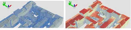
Figure 2. Visualization of global solar irradiation results for the months(left)January, and(right)July. Blue and red colours rep-resent low and high solar radiation values respectively.
3. RELEVANT STANDARDS
Before going into the details of Dynamizers, it is worth mention-ing existmention-ing standards leveraged by Dynamizers.
3.1 ISO 19123 - Schema for coverages
(ISO19123, 2005) defines coverage as a function from spatial, temporal or spatio-temporal domain to an attribute range. A cov-erage associates a position within its domain to a record of values of defined data types. This ISO standard defines discrete and con-tinuous coverages, containing three components: (i) a domain set, (ii) a range set, and (iii) a coverage function. The domain is a set of geometric and temporal objects described in terms of direct positions. The direct positions are associated with a spatial or temporal coordinate reference system. The range of a coverage is a set of feature attribute values (which may also be time-varying attribute values of geo-objects). The domain values are mapped to the range values using a coverage function.
3.2 TimeseriesML 1.0
TimeseriesML 1.0 (TimeseriesML, 2015) is a rather new OGC standard for the representation and exchange of observation data as timeseries. It is an extension of the work initially undertaken within (WaterML, 2014). However, the aim is to provide a domain-neutral model for the representation and exchange of timeseries data. TimeseriesML is a specialization of ISO 19123 Discrete Coverages, where domain is a set of ordered time instances where each is associated with a single value from the attribute space. The TimeseriesML schema supports two types of encodings: (i) an interleaved time-value pair encoding, whereby the time and value are coupled together and the coupling explicitly represents the mapping and (ii) a domain-range encoding, where the do-main and range are encoded separately, with a mapping function that allows looking up the range value for a given domain value. Sample XML encodings of this standard are illustrated below in section 5.1.
3.3 Observations and Measurements
Observations and Measurements (O&M) (O&M, 2013) is a generic information model for describing observations. The observation is modelled as a Feature within the context of the General Feature Model (ISO19101, 2014). An observation feature binds a result to a feature of interest, upon which the observation was made. The observed property is a property of the feature of interest. An observation uses a procedure to determine the value of the result, which may involve a sensor or an observer, analytical procedure, simulation or other numerical process. O&M is one of the core standards in the OGC Sensor Web Enablement suite, providing the response model for Sensor Observation Service (SOS) (SOS, 2012) and SensorThings API (Liang, 2016).
3.4 Sensor Web Enablement
The OGC SWE standards suite specifies interfaces and data en-codings to enable real-time integration of heterogeneous sensor networks. In this way, most types of sensors can be discovered, accessed and reused for creating web-accessible sensor appli-cations and services. SWE contains two important information models: (i) Sensor Model Language (SensorML), which defines an XML schema for describing the processes within sensor and observation processing systems, and provides information needed for discovery, georeferencing, and processing of observations, and (ii) Observations & Measurements (O&M), as described in section 3.3. In addition, SWE provides different interface models
and web services. The most important service within the scope of this paper is the Sensor Observation Service (SOS). It defines an open interface by which a client can obtain observation data and sensor and platform descriptions from one or more sensors.
Furthermore, the OGC SensorThings API is a recent OGC stan-dard, providing an open and unified way to interconnect resource-constrained Internet of Things (IoT) devices, data, and applica-tions over the Web. It is a very lightweight standard built on Web protocols and OGC SWE standards, and applies an easy-to-use REST-ful interface and JSON-based data encodings.
4. DYNAMIZERS 4.1 Introduction
Dynamizer is a new concept, which allows modeling and inte-grating dynamic properties within semantic 3D city models. It serves three major purposes:
1. Dynamizer is a data structure to represent dynamic values in different and generic ways. Such dynamic values may be given by tabulation of time/value pairs; patterns of time/-value pairs; by referencing an external file; or by retrieving observations from sensors.
2. Dynamizer delivers a method to enhance static city models by dynamic property values. It references a specific attribute (e.g. geometry, thematic data or appearance) of an object within a 3D city model providing dynamic values overriding the static value of the referenced object attribute.
3. Dynamizer objects establish explicit links between sensor/ob-servation data and the respective properties of city model objects that are measured by them. By making such explicit links with city object properties, the semantics of sensor data become implicitly defined by the city model.
In this way, Dynamizers can be used to inject dynamic variations of city object properties into an otherwise static representation. The advantage in using such approach is that it allows only se-lected properties of city models to be made dynamic. If an ap-plication does not support dynamic data, it simply does not al-low/include these special types of features.
4.2 Modeling dynamic values within Dynamizers
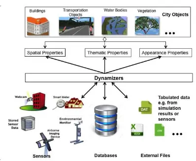
Figure 3. Conceptual representation of Dynamizers, allowing (i) the representation of time-variant values from sensors, simulation specific databases, and external files, (ii) enhancing the properties of city objects by overriding their static values
4.3 Repetitive Patterns (Atomic and Composite Timeseries) Dynamizers support absolute start and end points referencing a specific time reference system. The absolute time points can be mapped to attribute values and can be represented as tabulation of measured data. One common example illustrating such sce-nario is mapping of energy consumption values of a building for every hour in a day. However, in many applications, it is not suf-ficient just to provide a means for the tabulation of time-value pairs. They may require patterns to represent dynamic variations of properties based on statistics and general rules. In such scenar-ios, time cannot be described by absolute positions, but relative to absolute positions. In these cases, time may be defined for a non-specific year (e.g. averages over many years), but still clas-sified by relative time of an year. For example, January monthly summaries for the energy consumption of a building might be de-scribed as ”all-Januaries 2001-2010”. Similarly, the energy con-sumption values may reflect generic patterns for individual week-days/weekends in a week or a month. Another example scenario may also be determining patterns for specific seasons (such as spring, summer, autumn and winter) over ten years.
In order to support such patterns, Dynamizers introduce the con-cept of atomic and composite timeseries. Atomic timeseries rep-resent dynamic values having time points that can be based on local/relative time reference systems. This allows mapping cus-tomized time values such as weekdays, weekends, seasons etc. Furthermore, composite timeseries consist of nested timeseries with arbitrary depths. Such timeseries can be repeated several times to obtain specific patterns. For instance, an atomic time-series can be defined for a working day, a Saturday, and a Sunday
(represented by A, B, and C respectively). Now, a composite timeseries may contain five repetitions of atomic timeseries A to reflect a pattern of energy consumption values for all week-days. However, energy demand estimations may require sepa-rate patterns for weekdays and weekends requiring composition of multiple variation behaviours. Such complex behaviours may be expressed using composite timeseries, wherein a weekly pat-tern can be defined containing the energy values for all seven days of a week (represented as AAAAABC). The advantage in using such composite timeseries is that we can express time-varying data for an arbitrary long time period by combining various pat-terns. For example, if we need to determine the pattern for energy consumption values for evening hours on weekdays, an atomic timeseries can be defined for 6 hours (e.g. from 6 PM to mid-night). Further, the composite timeseries allows connecting addi-tional 6 hours for all weekdays in a week. An illustration of the representation of such complex patterns by atomic and composite timeseries is given in (Chaturvedi and Kolbe, 2015).
4.4 Sensors and observations
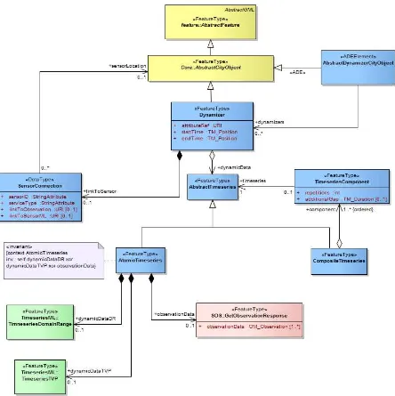
Figure 4. Dynamizer defined as UML model. Newly introduced classes are shown in blue. Classes shown in green and pink represent TimeseriesML 1.0 and Sensor Observation Service. Classes shown in yellow are from GML and CityGML respectively.
i By linking Dynamizers with sensors: Dynamizers support direct links to sensors and observations utilizing different requests, e.g. the DescribeSensor and GetObservation op-erations in case of OGC SOS. With such requests, sensor descriptions and observations are retrieved and linked with city objects. A sensor connection is defined by a unique sensor ID, the type of sensor service (e.g. OGC SOS and Sensor Things API), and URL links for the two different requests named above. Applications consuming CityGML plus Dynamizer data can utilize these links to retrieve the sensor data for the referenced web services.
ii By including sensor observations within Dynamizers: Dy-namizers allow representing sensor observations within them. Sensor observations are mainly encoded in O&M format. Dynamizers support inlining of O&M data representing sen-sor observation values, which then are injected into the at-tributes of specific city objects. This approach is useful to exchange sensor readings for a past time period together and consistently within the city model.
5. IMPLEMENTATION
Dynamizers are implemented as an Application Domain Exten-sion (ADE) for the CityGML standard. The ADE mechanism allows for the systematic extension of each CityGML object type by additional attributes as well as the introduction of new object types. This implementation allows Dynamizers to be used with the current version of CityGML (version 2.0).
de-noting the time span for which the Dynamizer provides dynamic values. The time points are modeled as TM Position defined by ISO 19108 (ISO19108, 2002), and are referenced to a specific time reference system (e.g. Gregorian Calendar). In addition, Dynamizers contain dynamic data in the form of a timeseries. The dynamic data is modeled asAbstractTimeseries, which is responsible for representing time-variant or dynamic values in different and generic ways. The timeseries may be modeled in two ways: (i)AtomicTimeseries, and (ii)CompositeTimeseries. AtomicTimeseriesconsists of eitherdynamicDataDR, dynamic-DataTVP, or observationData. It allows different representa-tions of timeseries such as TimeseriesML 1.0 encodings (inter-leaved time/value pair and domain-range), values from external files and databases, and observations encoded in O&M from sen-sors. Please note that these representations are mutually exclu-sive for eachAtomicTimeseriesobject. This condition is formally expressed using the Object Constraint Language (OCL) in the UML diagram. OCL (OCL, 2014) is a declarative language for describing rules that apply to Unified Modeling Language (UML) models.
CompositeTimeseriesis modeled in such a way that it composes of an ordered list ofAbstractTimeseries. CompositeTimeseries includes a component calledTimeseriesComponent, which de-notes the number of repetitions for a timeseries component. It also contains an attributeadditionalGap, which allows two non-overlapping timeseries, that have been separately collected, to connect in order to make a single timeseries. For example, if the latest two months of timeseries data is transferred from one sys-tem to a major archive, the series must be connected in order to make a full series over which the patterns can be determined (e.g. to determine yearly patterns). However, for a composite time-series, it is necessary to model time positions according to relative time reference system. According to ISO 19108, they may be de-fined as TM OrdinalEras within TM OrdinalReferenceSystems. It allows defining local reference systems for specific use cases.
Additionally, Dynamizers provide links to external sensors with the help of the datatypeSensorConnection. It contains four at-tributes (i)linkToObservation- link to observation response, (ii) linkToSensor- link to Sensor description encoded in SensorML format, (iii)sensorId- a unique identification of the sensor, and (iv)serviceType- the type of service such as SOS and Sensor-Things API. OGC SOS involves different requests for retrieving sensor descriptions and observations. DescribeSensor is used to retrieve sensor description in SensorML format. GetObservation is used to retrieve sensor observations encoded in O&M format. The request parameter also allows to include the specification of spatial and temporal filters.
5.1 Illustration of concept
This section shows an example for representing and supporting dynamic data within CityGML documents. Figure 5 shows the hourly reading of the energy consumption retrieved from a smart meter installed in a residential building. The usage (in kwh) is given against the time periods. The values of smart meters are usually stored and updated in a file or a database table. By us-ing OGC SWE standards, it is also possible to create an interop-erability layer, so that real-time consumption values can be re-trieved in a standardized way, e.g. by utilizing the SOS or Sen-sorThings API. These values may be stored as generic attributes within CityGML files. However, such generic attributes are static in the current version of CityGML, which means, all readings of smart meters would be required to be stored as separate at-tributes. Considering the highly dynamic nature of such values, it is cumbersome to store them in CityGML and other standards
Figure 5. Hourly energy consumption values from a smart meter.
of semantic 3D city models. The new Dynamizer feature allows us to map such highly dynamic values in different ways. At the same time, it refers to a specific attribute of a CityGML feature (here: a generic attribute) and overrides its value as per variations in time.
Below is an example illustrating how such dynamic values of a smart meter can be supported within CityGML.
<cityObjectMember>
<!--CityGML Building feature--> <bldg:Building gml:id = "buildingA">
<gen:doubleAttribute name = "ElecConsumption"> <gen:value>0.361</gen:value>
<dyn:Dynamizer gml:id = "ElecConsumptionTimeseries" > <dyn:attributeRef>//bldg:Building[@gml:id =’
<!--Multiple values can be represented--> </tsml:TimeseriesTVP>
A Building feature is represented asbuildingAand it contains a generic attribute named ElecConsumption, which stores hourly values of electricity consumption from a smart meter. Dynamizer is a new feature type, which contains a reference to the generic attributeElecConsumptionin XPath expression defined as:
//bldg:Building [@gml:id = ’buildingA’]/doubleAttribute[@name = ’ElecConsumption’]/gen:value
are absolute time positions for the dynamic values represented in the Dynamizer.dynamicDataTVPcontains dynamic values in time/value pair encoding as defined by TimeseriesML. The val-ues are interleaved with the absolute time positions. However, it also allows to provide regular spacing where it is only required to provide a start time and a duration of regular spacing. The next time positions are automatically determined with the help of spacing. It is also possible to define such dynamic values in Time-seriesML domain-range encoding, tabular form retrieved from an external file or a database, and observations from sensors encoded in O&M format.
A Dynamizer allows injecting dynamic values into a static at-tribute of a specific CityGML object. The advantage with this approach is that it does not affect other (static) attributes of the CityGML object. If an application does not support dynamic data, it simply does not consider the Dynamizer features. The given example is an illustration of a variation of a thematic at-tribute value of the CityGML feature. However, it is also possible to support dynamic variations in geometry and appearance of city objects.
There may also be scenarios when dynamic data for the same fea-ture is obtained from different sources for different time intervals. For example, energy consumption values are retrieved in a tabular data format from an external file for a time period A. For another time period B, such values are obtained from a statistical pattern, and for a third time period C, SOS observations from a smart me-ter are available. As shown below, our approach allows defining multiple Dynamizer features for the same CityGML attribute for non-overlapping time periods.
Time Period A: Inline data included from an external file <dyn:Dynamizer gml:id = "DynamizerA" >
<dyn:attributeRef>//bldg:Building[@gml:id =’buildingA
<!--More Time/value pair encodings--> </tsml:TimeseriesTVP>
<dyn:dynamicDataTVP> </dyn:AtomicTimeseries> </dyn:dynamicData> </dyn:Dynamizer>
Time Period B: Statistical patterns for weekdays and week-ends
<dyn:Dynamizer gml:id = "DynamizerB" >
<dyn:attributeRef>//bldg:Building[@gml:id =’buildingA
<!--Composite timeseries for weekdays patterns--> <dyn:CompositeTimeseries>
<!--Local time reference system--> <tsml:baseTime frame = "#localReference">
00:00:00</tsml:baseTime> <!--Regular spacing of 1 hour--> <tsml:spacing>PT1H</tsml:spacing>
<!--Further values of MeasurementTVP--> </tsml:TimeseriesTVP>
Time Period C: Sensor observations retrieved from OGC Sen-sor Observation Service
<dyn:Dynamizer gml:id = "DynamizerC" >
<dyn:attributeRef>//bldg:Building[@gml:id =’buildingA
<!--Reference to response from OGC SOS--> <sos:GetObservationResponse>
principle, Dynamizers inject dynamic variations of city object properties into the static representation. These variations are sup-ported for thematic, geometry, and appearance properties of city objects.
The concept has been implemented as an Application Domain Extension (ADE) for the CityGML standard. This implementa-tion allows to use such Dynamizer features with the current ver-sion CityGML 2.0. The advantage with this approach is that it allows for selected properties of city models to become dynamic without changing the original CityGML data model. If an appli-cation does not support dynamic data, it simply does not allow/in-clude these special types of features. Dynamizer is a feature type, which even allows to be used with the OGC Web Feature Service. No extension of other OGC standards is required.
Dynamizers are a crucial concept for smart city applications and thus, are being tested in the OGC Future Cities Pilot Phase 1. Within the scope of the pilot, datasets and instance documents will be developed for conducting and demonstrating various pi-lot scenarios. Regarding sensors, the current Dynamizer model is limited to the OGC Sensor Observation Service. However, in the future, it will be interesting to extend support to other sensor APIs like the OGC Sensor Things API. It will also be important to investigate how Dynamizers can be interpreted by visualiza-tion clients. Dynamizers are intended to become part of the next version of CityGML (version 3.0).
The Dynamizer concept is general in the sense that it could also be applied to other GML-based application schemas including the European INSPIRE data themes and national standards for topog-raphy and cadasters like the British Ordnance Survey Mastermap or the German cadaster standard ALKIS.
ACKNOWLEDGEMENTS
Part of this work has been carried out within the project Smart, Sustainable Districts funded by the Climate-KIC of the European Institute of Innovation and Technology (EIT). We thank Climate-KIC and the EIT for supporting this work. We also acknowledge OGC Future Cities Pilot 1 for supporting this work.
REFERENCES
Chaturvedi, K. and Kolbe, T. H., 2015. Dynamizers - Model-ing and ImplementModel-ing Dynamic Properties for Semantic 3d City Models. In: 3rd Eurographics Workshop on Urban Data Mod-elling and Visualisation, TU Delft, The Netherlands.
Chaturvedi, K., Smyth, C. S., Gesquiere, G., Kutzner, T. and Kolbe, T. H., 2015. Managing versions and history within se-mantic 3d city models for the next generation of citygml. In: Selected papers from the 3D GeoInfo 2015 Conference, Springer.
CityNext, 2015. Microsoft CityNext.
https://partner.microsoft.com/en-US/Solutions/CityNext.
CitySDK, 2015. CitySDK City Service Development Kit. http://www.citysdk.eu/.
Degbelo, A., Granell, C., Trilles, S., Bhattacharya, D., Casteleyn, S. and Kray, C., 2016. Opening up Smart Cities: Citizen-Centric Challenges and Opportunities from GIScience. ISPRS Interna-tional Journal of Geo-Information5(2), pp. 16.
Eastman, C. M., 1999. Building product models: computer envi-ronments, supporting design and construction. CRC press.
FCP1, 2016. OGC Call for Proposals for
a Future City Pilot Phase 1 project | OGC.
http://www.opengeospatial.org/pressroom/pressreleases/2371.
Gr¨oger, G., Kolbe, T. H., Nagel, C. and H¨afele, K.-H., 2012. OGC City Geography Markup Language (CityGML) Encoding Standard|Version 2.0.0|OGC Document No. 12-019.
IBM, 2016. IBM Smarter Cities - Future cities - United States. http://www.ibm.com/smarterplanet/us/en/smarter cities/overview/.
ISO19101, 2014. ISO 19101-1:2014 - Geographic information – Reference model – Part 1: Fundamentals.
ISO19108, 2002. ISO 19108:2002 - Geographic information – Temporal schema.
ISO19123, 2005. ISO 19123:2005 - Geographic information – Schema for coverage geometry and functions.
Kaden, R. and Kolbe, T. H., 2013. City-wide total energy de-mand estimation of buildings using semantic 3d city models and statistical data. In: Proc. of the 8th International 3D GeoInfo Conference, Vol. 2, p. W1.
Kolbe, T. H., 2009.Representing and exchanging 3D city models with CityGML. 3D Geo-Information Sciences, Springer, pp. 15– 31.
Lee, J., Li, K.-J., Zlatanova, S., Kolbe, T. H., Nagel, C. and Becker, T., 2014. Indoor GML|OGC 14-005r3.
Liang, S., 2016. SensorThings SWG | OGC.
http://www.opengeospatial.org/projects/groups/sensorthings.
Morel, M. and Gesquire, G., 2014. Managing Temporal Change of Cities with CityGML. In:Eurographics Workshop on Urban Data Modelling and Visualisation, Strasbourg, France.
Moshrefzadeh, M. and Kolbe, T. H., 2016. Smart District Data Infrastructure for Smart and Sustainable Cities. In: 3th Inter-national Conference on Design & Decision Support Systems in Architecture and Urban Planning.
OCL, 2014. Object Constraint Language.
http://www.omg.org/spec/OCL/.
OGC, 2015. OGC Standards and Supporting Documents|OGC. http://www.opengeospatial.org/standards.
OGC, 2016. OGC Interoperability Program | OGC.
http://www.opengeospatial.org/ogc/programs/ip.
O&M, 2013. Observations and Measurements|OGC 10-004r3.
Percivall, G., 2015. OGC Smart Cities
Spa-tial Information Framework | OGC 14-115.
http://www.opengeospatial.org/pressroom/pressreleases/2181.
Prinaud, C., Gay, G. and Gesquire, G., 2015. Exploration of the changing structure of cities: Challenges for temporal city models. In:2015 Digital Heritage, Vol. 2, pp. 73–76.
SOS, 2012. Sensor Observation Service|OGC 12-006.
SSD, 2015. Smart Sustainable Districts. http://www.climate- kic.org/wp-content/uploads/2013/04/Smart-Sustainable-Districts Climate-KIC external.pdf.
SWE, 2015. Sensor Web Enablement (SWE)|OGC 06-021r4.
TimeseriesML, 2015. Timeseries Profile of Observations and Measurements|OGC 15-043r3.
WaterML, 2014. OGC WaterML|OGC 10-126r4.
XPath, 2011. XML Path Language (XPath) 2.0 (Second Edition). http://www.w3.org/TR/xpath20/.
Yin, C., Xiong, Z., Chen, H., Wang, J., Cooper, D. and David, B., 2015. A literature survey on smart cities. Science China Information Sciences58(10), pp. 1–18.