INVESTIGATION OF STABLE ISOTOPE OF
18O AND
2H IN SHALLOW GROUNDWATER
FROM KARAWANG AREA
E. Ristin Pujiindiyati*
Center for the Application of Isotopes and Radiation Technology, National Nuclear Energy Agency, Jln. Cinere Pasar Jum’at PO.Box 7002 JKSKL, Jakarta 12070
Received 8 December 2007; Accepted 21 March 2008
ABSTRACT
Karawang area is well known as an agriculture area and 2% area is utilized for industries. Clean water demands increase due to developing industry development and population increasement. The origin of groundwater is necessary to keep the sustainability of water resources in this area. Stable isotopes such as 18O and 2H can be used as a parameter to trace the ground water origin. The methods used were Epstein-Mayeda and Zinc reduction for analysis 18O and 2H, respectively. Sampling period was conducted in major dry season in year 2002. The result showed that evaporation effect had influenced to the content of both isotopes in its shallow groundwater that caused a slope shift from its local meteoric line. The origin of its shallow groundwater was from rainwater infiltrating directly in less than 10 m altitude. Citarum River showed more depleted values in both isotopes compared to shallow groundwater and it indicated that its water might originate from spring at the altitude of 600 m.
Keywords: oxygene-18, deuterium, groundwater, isotope.
INTRODUCTION
Karawang area has fertile soil so that it is suitable for agriculture area. Since a long time ago, this area has been well known as a rice-barn in Java Island. According to data from Agriculture Service for Food Crops of Karawang in year 2000, this area can produce 1.105.351 ton rice for 184.117 ha harvested area. The utilization of this regency with total area 1753.27 km2 is 70% for agriculture; 2 % for industries such as chemicals, textiles, mechinary, electronic and pulp; 11% for settlement (937 people per km2) and the rest is still as uncultivated area [1].
Mostly, Karawang has flat land area with altitude 0-5 m and only a few areas are hilly land to 1200 m in the southern part. Karawang is bounded by Java Sea in the northern part and Subang regency in eastern part, which is also as an agriculture area. Lithological composition of rock in surface aquifer in Karawang is alluvial plain and river deposits, mainly consist of silt, sand, gravels and pable. The thickness of this aquifer is less than 56 m. Its stratigraphy is quartenary and it permeability is generally moderate to high with range between 2.24 m/day to 10 m/day [1, 2].
Karawang is bordered by Bekasi regency in western part. The latter has developed rapidly as an industrial center since 20 years ago and its consequence, this area has become an urban area. The trend of increasing people density is also faced by Karawang regency due to the extent of industrial area. It is clearly signed by rapid growing in complex of houses and other facilities such as hospitals, freeway and petrol stations.
One important problem that may come up as a consequence of rapid developing city is increasing clean
water demand. To supply the water for daily needs, mostly, the people take groundwater from dug wells and pump wells. Only a few people can use the facility of purified water because of less capacity in producing clean water or some obstacles in its distribution. Municipal of Karawang use Citarum River to produce purified water beside as irrigation water, brackish water ponds and electricity. Some industries take groundwater by pumping it in shallow and in deep aquifer with high capacity. Therefore, high growing of industries can cause over- exploitation of groundwater and finally, this can disturb the equilibrium of groundwater hydrostatics pressure. Moreover, recharge area as an input of groundwater might have been covered by high dense buildings or golf-course as commonly taken place in urban area.
According to chemical data from geology survey, shallow groundwater in some areas in northern part is indicated as rather brackish water because of seawater intrusion [2]. This effect will be more intensive in decreasing quality of groundwater and increasing areas contaminated by sea water if the equilibrium of input and output groundwater can not be kept well. Other indications of groundwater resources problem in Karawang are flood disaster occurred in every rainy season and lack of groundwater or river water supply either for domestic or irrigation purposes in dry season. Certainly, these cause decreasing harvested areas.
Environmental isotope of oxygen-18 (18O) and deuterium (2H) offer an alternative tool as an addition to chemical parameter in groundwater resource problems. Both isotopes can play a role in most contaminant hydrogeology studies by responding to questions of groundwater recharge origin, residence time, response to meteorological events and mixing of groundwater in
* Tel/Fax : 0062-21-7690709 / 0062-21-7691607 Email address : ristinpi@batan.go.id
water-supply aquifer. Fractionation effect between the lighter and heavier isotopes provides a characteristic composition in water. In hydrological cycle of 18O and 2H, local temperature controls the extent of fractionation effect of these isotopes in precipitation and provides the input function to trace groundwater recharge. Characterizing these isotope distributions in meteoric waters is essential in determining this input function. The local meteoric water line provides a baseline for groundwater [3-5].
In this observation, a suite of 22 samples from shallow groundwater and 6 samples from Citarum River were collected during major dry seasons in year 2002. Local meteoric line was taken from Jakarta precipitation as presented by Wandowo [6] . The main objective of this observation is to identify the recharge area for shallow groundwater in Karawang and Citarum River crossing to Karawang city based on interpretation of oxygen-18 and deuterium in water.
EXPERIMENTAL SECTION
Material
The materials used were high pure CO2 gas
(99.9%) reference, liquid nitrogen, activated Zn granular, JAWS (Jakarta Water Standard), acetone p.a, high pure hydrogen gas (99.9%) reference.
Instruments
The equipments used were Isogas Sira 9 mass spectrometer, Isogas Isoprep-18 line, glass vacuum line, cryocool immersion cooler, furnace, digital thermometer, micropipette, pipette tips, Kjedhal glass tubes, electronic balance, 20-mL glass vials, rotary pump and manometer.
Procedure
Sampling methods
For determination of the isotope ratio of 18O/16O and 2H/1H in water, groundwater samples were collected from either dug wells or pump wells, which are had by local people. Citarum River samples streamed through three irrigation channels (West, North and Centre Tarum) were collected from beneath the air-surface interface. The 20 mL glass bottles were filled fully with water. Place the cap on the top of bottle while still out of contact with air and seal tightly. Always keep the water was not in contact with air until opened and ready for analysis in the laboratory of Hydrology - Center for the Application of Isotopes and Radiation Technology, National Nuclear Energy Agency. Sampling period was scheduled during major dry season of June, July and August in year 2002.
Analysisof 18O/160 in water [7]
In the laboratory, 18O/16O abundance ratios in water were determined by mass spectrometric analysis of CO2 according to a method developed by
Epstein-Mayeda. Analysis was based on carbon dioxide released from 18O isotopic exchange reaction between water samples and CO2 gas reference. Amount of 2 mL
water samples in vessel reaction, which have been evacuated, were streamed CO2 gas and shake at 25
o
C for overnight. Isotopically equilibration between water and CO2 gas occurred as the following reaction:
18 18 16 16
2 (l) 2 (g) 2 (l) 2 (g)
H O + C O ⎯⎯→ H O + C O (1)
This reaction was taken place in isoprep-18 line equipped by 24 vessel reaction and directly connected to SIRA-9 Isogas mass spectrometer.
Analysisof 2H/1H in water[8-9]
Analysisof 2H/1H in water samples was done on hydrogen gas obtained through high temperature reduction. Amount of 250 mg Zn metals were placed in Kjedhal tubes then 10 μL water samples were injected near to the surface of zinc batch. The tubes were immersed in liquid nitrogen to freeze-down the injected water and evacuated in a sufficiently low pressure to less than 10-2 mbar. The tubes should be sealed properly. The seven prepared samples were burned in furnace at the temperature of 450 oC over 60 minutes. The reduction process between water and Zn metals occurred quantitatively as the following reaction:
2 (l) (s) 2 (g) (s)
H O +Zn ⎯⎯→H +ZnO (2)
The formed hydrogen gas through this reaction can be seen visually as a dark cloud stacking on Kjedhal tubes. It signed that the reaction above has completed. Let the tubes cooled in room temperature before injecting hydrogen gas in mass spectrometer. Two internal standards of water (JAWS) were also prepared as two mentioned procedures above for each
2
H and 18O analysis.
Measurements of isotope ratio value[5,10]
Isotope ratio value was expressed with delta δ (delta) notation in per mill (0/00) and defined as follow:
sample reference
reference
R - R
0
δ( ) = × 1000
00 R
“R” notation is, in the case of water, the 18O/16O or
2
H/1H. A reference for oxygen and deuterium in water is used an international standard of SMOW (Standard Mean Ocean Water).
RESULT AND DISCUSSION
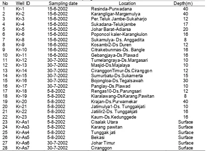
The shallow groundwater from Karawang and surface water from Citarum River sampled in this study were indicated in Fig 1, together with the location of sampling stations. Map of Karawang area used in this investigation is adopted from Bakosurtanal [11]. More detailed locations and depth of wells for 22 shallow groundwater and 6 Citarum River samples in Karawang were listed at Table 1.
Previously, the results of major chemicals constituents such as SO42-, Cl-, HCO3- for anions and
Na+, Ca2+, Mg2+, K+ for cations in the same sampling site had been studied. Mostly, the shallow groundwater samples had water type of NaHCO3, which were
commonly characterized as a fresh water type but some of those showed a trend of gypsum or carbonate rock dissolution. In the other hand, Citarum River significantly showed a NaHCO3 water type [12].
The results for stable isotope analysis were presented at Table 2. The values of δ 18O and δ 2H in H2O from shallow groundwater samples ranged from
-3.210/00 to -6.25 0
/00 and -21.4 0
/00 to -46.7 0
/00,
respectively. Some areas had more enriched values either δ 18O (-30/00) or δ
2
H (-210/00) indicated that an
evaporation process had carried out more intensively. It could be due to differences in well depth, pore size of soil and open or closed wells.
Fig 1. Sampling locations for shallow groundwater and Citarum River in Karawang area.
Table 1. Sampling location and depth of wells
No Well ID Sampling date Location Depth(m)
1 Kr-1 15-6-2002 Resinda-Purwadana 40
2 Kr-2 15-6-2002 Karangligar-Margamulya 40
3 Kr-3 15-6-2002 Per.Teluk Jambe-Sukaharjo 12
4 Kr-4 15-6-2002 Sukadana-Telukjambe 17
5 Kr-5 15-6-2002 Johar Barat-Adiarsa 20
6 Kr-6 15-6-2002 Poponcol kaler-Karangkulon 16
7 Kr-8 15-6-2002 Sukamulya- Ds. Anggadita 8
8 Kr-9 16-6-2002 Kosambi2-Ds Duren 12
9 Kr-10 16-6-2002 Citrakebunmas-Ds. Bangle 16
10 Kr-11 16-6-2002 Gebangjaya-Ds.Plawad 16
11 Kr-12 30-7-2002 Tumelangraya-Ds.Margasari 10
12 Kr-13 30-7-2002 Masjid-Ds.Majalaya 10
13 Kr-14 30-7-2002 CiranggonTimur-Ds.Ciranggon 12
14 Kr-15 30-7-2002 Sumurbatu-Ds.Sukamerta 15
15 Kr-16 30-7-2002 Bojongloa-Ds.Tegalsawah 30
16 Kr-17 30-7-2002 Panglay-Ds.Plawad 10
17 Kr-18 5-8-2002 Rengas10-Ds.Parungsari 12
18 Kr-19 5-8-2002 Kiaralawang-DsKarang.Pawitan 8
19 Kr-20 5-8-2002 Krajan-Ds.Purwamekar 40
20 Kr-21 5-8-2002 Jatimulya1-Ds. Tunggakjati 10
21 Kr-22 5-8-2002 Jatiilir2-Ds. Tunggakjati 16
22 Kr-23 5-8-2002 Kaum-Ds.Kedunggede 16
23 Kr-As1 5-8-2002 Cisalak Utara Surface
24 Kr-As3 5-8-2002 Karang pawitan Surface
25 Kr-As4 5-8-2002 Tunggak jati Surface
26 Kr-As5 5-8-2002 Bekasi Surface
27 Kr-As6 30-7-2002 Johar Timur Surface
28 Kr-As7 30-7-2002 Ciranggon Surface
δ D = 7.8 δ 18Ο + 13.0
local meteoric water
-100
Karawang shallow groundwater, Citarum River and rainwater at various altitudes
Fig 2. Relationships of δ
Karawang shallow groundwater, Citarum River and rainwater at various altitudes
Fig 3. Distribution of δ
In contrast to groundwater, Citarum River samples had more depleted values in either δ 18O or δ 2H. Their
-40.9 0/00, respectively. The depleted values indicated
that the water of Citarum River might originate from rainwater infiltrating in higher altitude areas [3-5].
In contrast to groundwater, Citarum River samples had more depleted values in either δ
Plotting δ 18O versus δ 2H from groundwater, Citarum River and local meteroic water was given at Fig 2. Local meteoric water was collected at different altitudes from Tongkol-Jakarta (10 m) to Tugu –Bogor (1020 m) as observed by Wandowo [6]. This figure clearly showed that the group of shallow groundwater samples rather lied separately with the group of Citarum River samples. It could be explained that both groups had different water origin. In hydrological cycle, the rainwater in higher altitudes had more depleted values in both δ 18O and δ 2H due to temperature effect that caused different isotopic fractionations [3-5].
Plotting δ
Table 2. Stable isotope of O-18 and H-2 in water from Karawang shallow groundwater and Citarum River
Table 2. Stable isotope of O-18 and H-2 in water from Karawang shallow groundwater and Citarum River
No.
No. Well ID Well ID Oxygen-18 Oxygen-18 Deuterium Deuterium
18
O vs δ 2H in H2O from
Karawang shallow groundwater, Citarum River and rainwater at various altitudes
18
O (0/00 SMOW) in H2O in
Karawang shallow groundwater, Citarum River and rainwater at various altitudes
18
-40.9 0/00, respectively. The depleted values indicated
that the water of Citarum River might originate from rainwater infiltrating in higher altitude areas [3-5].
18
O versus δ 2H from groundwater, Citarum River and local meteroic water was given at Fig 2. Local meteoric water was collected at different altitudes from Tongkol-Jakarta (10 m) to Tugu –Bogor (1020 m) as observed by Wandowo [6]. This figure clearly showed that the group of shallow groundwater samples rather lied separately with the group of Citarum River samples. It could be explained that both groups had different water origin. In hydrological cycle, the rainwater in higher altitudes had more depleted values in both δ 18O and δ 2H due to temperature effect that caused different isotopic fractionations [3-5].
(0/00 SMOW) (0/00 SMOW)
The highest distribution frequency of δ 18O in these groundwater samples was around -50/00. This
value was rather more enriched than δ 18O from rainwater at lowest observed altitude of 10 m, which had δ 18O value of -5.680/00 [6]. Fig 3 indicated the
effect of increasing altitudes related to the change of δ
18
O values. These shallow groundwater samples also have a more enriched value of δ18O than that value of Citarum River. Its enriched value relative to both the average rainfall and Citarum River water performed that shallow groundwater sources in alluvial deposit in Karawang could dominantly derivate from direct rainwater infiltration.
As illustrated at Fig 3, the mean value of δ 18O in Citarum River was similar to that value in rainwater from the elevation of 600 m, which had -6.710/00 [6]. It
had more quite narrow range compared to ground- water. It was due to river water flow was faster than the rate of evaporation process and mixing with base flow of groundwater [5].
Shifting the scatter of isotopic composition of groundwater away from the meteoric water line defined that evaporation process might carry out, as clearly shown at Fig 2. The groundwater samples fall on regression line of δ2H = 7.2 δ 18O - 0.1 (slope of 7.2, R2= 0.76) that had shifted from initial sources of δ2H = 7.8 δ
18
O +13 for local meteoric water line (slope of 7.8) [6]. This slope shift was caused by highly evaporation in major of dry season during sampling period. As comparison, rainfall in Karawang in dry season of August 2000 was 8 mm (sampling date) whereas rainfall in major rainy season of February 2000 was 261 mm. The average humidity was 80% [1]. The slope of this groundwater slightly shifted from meteoric water line but the value was not less than 5, slope of strong evaporation area in arid regions [4].
A mixing process between direct rainwater infiltration and evaporated water due to hot landscapes had influenced to its isotopic compositions in shallow groundwater of Karawang. This slope would shift closed to local meteoric water line if the little evidence of evaporation occurred as taken place in rainy seasons [4]. Evaporation also could occur from surface water during run off prior to infiltration, from the unsaturated zone itself or from the water table. Evaporation during run off and infiltration in arid landscape was generally associated with groundwater in alluvial aquifers along drainage network. For groundwater recharged by direct infiltration through the soil or sand, evaporation from unsaturated zone could occur.
CONCLUSION
The stable isotopes values of δ 18O and δ 2H in H2O from Karawang shallow groundwater ranged from
-3.210/00 to -6.25 0
/00 and -21.4 0
/00 to -46.7 0
/00, respectively.
Citarum River samples had more depleted values with mean value of -6.70/00 for δ 18O and -40.90/00 for δ 2H.
Plotting both isotope values gave a regression line of δ
2
H = 7.2 δ 18O - 0.1 for its shallow groundwater. This line had shifted away from local meteoric line of δ 2H = 7.8 δ18
O +13 indicated that evaporation effect had occurred during sampling periods conducted in major dry season in year 2002.
Relating to stable isotope content from local mateoric water at gradually altitudes, it was known that recharge area for Karawang shallow groundwater derived from direct infiltration of rain water at the altitude less than 10 m. The more depleted isotope values of Citarum River crossing to Karawang area indicated that this river water originate from springs infiltrating from a higher altitude of 600 m.
ACKNOWLEDGEMENT
This study was supported by National Atomic Energy Agency through Research Proposal in year 2002. The author gratefully thanks to Prof. K. Froehlich for valuable discussion concerning this study during participating in IAEA/JR-IHG Training Course on Isotope Hydrology in year 2002 in Graz-Austria. The author also thanks to Bungkus Pratikno for his intensive lecture in operating a SIRA-9 Isogas mass spectrometer. Acknowledgements are also expressed to Hydrology staffs for their helps in sampling activities.
REFFERENCES
1. Pemda Karawang., 2000, Karawang dalam Angka, Pusat Statistik Kabupaten Karawang, 10-15
2. Pasaribu, M and Sungkowo, W., 1999, Peta Hidrogeologi Indonesia 1:100.000. Catatan Penerangan Lembar 1209-5 Karawang dan 1210-2 Sedari, Departemen Pertambangan dan Energi-Direktorat Jenderal Geologi dan Sumber Daya Mineral, Bandung.
3. Fritz, P and Fontes, C.H., ”Oxygen and Deuterium Isotopes” in Handbook of Environmental Isotope
Geochemistry, Elsevier Publishers Amsterdam,
1980, 165-192.
4. Clark, I and Fritz, P., “Precipitation” in Environmental Isotopes in Hydrogeology, Lewis publishers Boca Raton New York, 1997, 63-77 5. IAEA, “Atmospheric water and Groundwater” in
Stable Isotope in Hydrology Technical Report Series 210, International Atomic Energy Agency Vienna, 1981,103-131 and 223-236.
6. Wandowo., 2000., Laporan Akhir Riset Unggulan Terpadu V Bidang Teknologi Perlindungan Lingkungan 1997-2000, Kantor Menteri Riset dan Teknologi – Dewan Riset Nasional, Jakarta.
7. Epstein, S and Mayeda, T.K., 1959,
Geochim.Cosmochim.Acta ., 4, 213-224
8. Coleman, M., Shepherd, T.J., Durham, J.J., Rouse, J.E and Moore, G.R., 1982, Anal. Chem., 54, 993-995
9. Tanweer, A., Hut, G and Burgman, J.O., 1988, Chem. Geol., 73, 199-203.
10. Hoefs, J., “Theoritical and Experimental Principles” in Stable Isotope Geochemistry, Springer-Verlag Berlin Heidelberg New York, 1980, 18
11. Bakosurtanal., 1998, Peta Rupabumi Digital Indonesia 1:25.000 –Lembar 1209-523 Karawang, Badan Koordinasi Survey dan Pemetaan Nasional, Jakarta
12. Ristin, P.I., 2006, Sigma., 9, 107-118.