See discussions, stats, and author profiles for this publication at: https://www.researchgate.net/publication/229988065
The effects of land use changes and
management types on surface soil properties in
Kafkasör Protected Area in Artvin...
Article in Land Degradation and Development · November 2010
DOI: 10.1002/ldr.1000
CITATIONS
12
READS
68
3 authors, including:
Some of the authors of this publication are also working on these related projects:
Effect of different organic waste materials on fertilizer quality and biomass yield of Californian red wormsView project
TUBITAK TOVAG-108O414 The effects of Cu, Cr and As leached out from CCAtreated utility poles in Artvin area on soil and ground water and removal of Cu, Cr and As from CCA-treated wood materials. Project Leader. 15.11.2008–15.05.2012.View project
Turan YUKSEK
Recep Tayyip Erdoğan Üniversitesi (Recep Ta…
20PUBLICATIONS 74CITATIONS
SEE PROFILE
Oguz Kurdoglu
Karadeniz Technical University
18PUBLICATIONS 46CITATIONS
SEE PROFILE
All content following this page was uploaded by Turan YUKSEK on 13 March 2015.
THE EFFECTS OF LAND USE CHANGES AND MANAGEMENT TYPES ON SURFACE
SOIL PROPERTIES IN KAFKASO
¨ R PROTECTED AREA IN ARTVIN, TURKEY
T. YU¨ KSEK1*, O. KURDOG˘LU2AND F. YU¨ KSEK3
1
Department of Landscape and Ornamental Plants, Rize University, Pazar Vocational School, 53300 Pazar-Rize, Turkey 2
Department of Forest Engineering, Artvin C¸ oruh University, 08000 Artvin, Turkey 3
Pazar Forest Management Directorate, 53300 Pazar-Rize, Turkey
Received 22 December 2008; Revised 3 March 2010; Accepted 29 March 2010
ABSTRACT
The effect of visitors’ activities and management types on surface soil properties continues to be an issue of concern in protected areas. Little evidence was documented regarding the effects of visitors’ activities on surface soil properties in forest and grassland in forest gap in protected areas in Turkey. The research focused on the evaluation of the effect of visitor activities and management types on the surface soil environmental conditions in Kafkaso¨r Protected Area. For this purpose six different land use types were identified and characterized as control (Natural Old Forest), moderately used forestry (MUF), heavily used forestry (HUF), light grazing in glade (LGG), moderately used glade (MUG) and heavily used glade (HUG). Fourteen soil properties (such as field capacity (FC), permanent wilting point (PWP), bulk density, total porosity, soil penetration resistance (SPR), soil organic matter (SOM), etc. . .) were measured on 96 soil pits at 0–5 and 5–10 cm soil depths in six experimental sites in the study area. According to land use intensity, FC, plant available water (PAW), total porosity, saturated hydraulic conductivity, cumulative infiltration and SOM decreased significantly while bulk density, PWP and SPR increased significantly in all experimental sites compared to control site. Copyright#2010 John Wiley & Sons, Ltd.
key words: bulk density; cumulative infiltration; saturated hydraulic conductivity; soil penetration resistance; visitor activities; Turkey; compaction;
trampling
INTRODUCTION
Protected areas worldwide, such as national parks, nature reserves and wilderness areas are commonly established and managed to safeguard natural and cultural resources. Internal and external sources of human impact, including encroach-ing development, pollution, introduction of exotic species and recreation or tourism visitation, increasingly threaten to compromise these purposes. Among these sources, recrea-tion and tourism visitarecrea-tion presents a perennial and growing management challenge to protected area managers, who are liable to protect park resources while also providing appropriate recreational opportunities. These obligations require managers to carefully manage visitation and any negative environmental effect or impact. Various forms of resource impact have been described, including vegetation loss, soil exposure, compaction and erosion, tree and seedling damage, wildlife disturbance and miscellaneous damage caused by depreciative behaviour (Cole, 1987). Soil systems are not static, but are subject to natural changes.
These include both directional and cyclic changes. Changes can occur over time units ranging from days to millennia. Impacts of human activity are superimposed on these natural changes and their significance should be evaluated in the light of natural changes. Assessment of the sensitivity of the soil landscape to further change should also consider natural variability in both space and time (Grieve, 2001). Recrea-tional activities significantly damage physical and hydro-physical properties of surface soils. Currently, the demand for recreational diversity has been rapidly increasing and this makes planning and protection difficult in Kafkaso¨r protected area (Yu¨ksek et al., 2008). Intensive recreational use of forested soils leads to soil compaction and increased bulk densities in area. An important consequence of increased bulk density is reduced soil water intake capacity and thus increased losses by surface runoff (Vimmerstadt et al., 1982). Ball games and other activities may wear out a good stand of grassland and damage topsoil structure (Troeh and Thompson, 1993). The major cause of soil compaction is the traffic over the fields (Shortet al., 1986; Yu¨kseket al., 2008). Tractors, implements, livestock and even humans (walk-ing, camp(walk-ing, car parking) can compact soil when travelling across a field (Craul, 1994). How much compaction occurs depends on many factors: soil physical conditions, soil types Land Degrad. Develop.21: 582–590 (2010)
Published online 28 June 2010 in Wiley Online Library (wileyonlinelibrary.com)DOI: 10.1002/ldr.1000
* Correspondence to: T. Yu¨ksek, Department of Landscape and Ornamental Plants, Rize University, Pazar Vocational School, 53300 Pazar-Rize, Tur-key.
(texture) as well as weight and design of the load on soil, distribution of the load over the number of axles and tires and number of trips made over the same area (Brady and Weil, 1999). Tractors and other heavy equipment compact the soil to considerable depths (Daum, 1996) and significant changes occur in soil strength and saturated hydraulic conductivity due to the traffic. The most significant impact occurs in surface layer. Then soil compaction reduces soil infiltrability and permeability (Froehlich and McNabb, 1983.) Similarly, if the compaction is accomplished with proper moisture control, the movement of capillary water is minimized (Gent and Ballard, 1985). It is well known that root and plant growth significantly decreases when surface soil properties (especially physical and hydraulic properties) are damaged. Kerbiriouet al. (2008) reported that the degree of activity concentration on individual campsites have a substantial effect on the magnitude of vegetation loss and species richness.
Kafkaso¨r protected area is located in Artvin Province which has rich bio-diversity. According to IUCN risk (EN, VU, LR(lc), LR(cd), LR(nt) and DD) categories there are a total of 30 taxa, all endemics, and 14 non-endemics in Kafkaso¨r and its close environments (Eminag˘aog˘lu and Ans¸in, 2005). Besides that, the vegetation of Kafkaso¨r protected area and its close environment have a very important role for soil conservation, and vegetation type of Kafkaso¨r has critical role to reduce landslide risk in this area. It is well known that there are some areas (lands), which have high landslide risk between Artvin City and Kafkaso¨r protected area (Anonymous, 1993). There is a strong need to assess the changes in soil properties in these protected areas and apply this knowledge to effective or sustainable ecosystem management. Maintenance of these ecosystems essentially depends on soil quality and water availability. Since soil quality is a function of soil physical and chemical properties, land use were assessed in this area using soil chemical and physical properties as indicators. Therefore, to maintain vegetation structure of Kafkaso¨r protected area, we must protect surface soil physical and hydraulic properties and we must establish best management strategies.
The aim of this study was to evaluate the effect of different density of visitor activities on surface soil environmental conditions in the different ecosystems in Kafkaso¨r protected area in Artvin, Turkey. It is hoped that this information will provide guidance to managers in future visitor capacity decisions and in the further development of appropriate minimum impact visitor practices in Kafkaso¨r protected area.
MATERIALS AND METHODS
Site Description and History
The study was conducted in Kafkaso¨r-Artvin in the North-Eastern Blacksea of Turkey. The study area is located at 41*
090 altitude of the area is between 1150 and 1280 m above sea level. Since there is no meteorological station in the study area, the nearest meteorological station in Artvin was taken into account. The climate is sub-humid, with a long-term annual average rainfall of 689 mm, while it was 880 mm in 2007, with a minimum in summer (103 mm), and maximum in winter (262 mm) and the mean annual temperature is 1238C in Artvin Meteorological station (Anonymous, 2007). Heavy rains occur in a short time period during the summer season, while high snow levels (more than 1 m high) occur in the winter season. The study area is moderately sloped (202 per cent). The soils of the area were classified as brown forest soils with sandy–loam — loam texture according to International Soil Classification System (ISCS) (Anonymous, 1993; Yu¨ksek and O¨ lmez, 2002). The rock mass is extensively volcanically disrupted and parent material is andesite. The forest site of study area consists ofPicea orientalisLink (745 per cent),Carpinus betulus (L.) (22 per cent), Quercus petraea (L.) (65 per cent), Fagus orientalis (L.) (72 per cent), Abies nord-mannianaStev (74 per cent),Pinus sylvestris(L.) (22 per cent) (Anonymous, 2005) and grassland in forest gap consists ofBrachypodium pinnatum(L.),Bromus tectorum (L.), Avena sativa (L.), Poa annua (L.), P. trivialis (L.), P. nemoralis(L.),P. bulbosa(L.),Agrostis stolonifera(L.), Dactylis glomerata (L.), Cynosurus echinatus (L.), C. cristatus (L.), Phleum alpinum (L.), P. pratense (L.), Cynodon dactylon(L.), Trifolium pratense (L.), T. repens (L.) andT. arvense (L.) (Eminag˘aog˘lu and Ans¸in, 2005). Kafkaso¨r and its environment have different topography, rich and abundant vegetation, clean and fresh air and it is 8 km away from the city centre of Artvin. The landscape beauty of Kafkaso¨r has been advertised often on magazines and television programs after 1990s; therefore, the number of visitors has been increasing from day to day. It was estimated that more than 100 000 people visited Kafkaso¨r during 2006, and most of the visitors visited Kafkasor from July to September. Beside prevalent recreational activities, Kafkaso¨r Culture, Art and Tourism Festival has been carried on since 1984 and tourism is nowadays the main source of income for local inhabitants since the abandonment of traditional agriculture, and there is a strong social and economical pressure for tourism in protected areas. The festival area is about 23 ha and there is no accepted land use plan for this area. Except for the traditional Kafkaso¨r festival, people can enter the area free of charge and can camp in any part of grassland in forest gap and there is randomly light grazing in grassland in forest gap.
Experimental Design and Soil Sampling
Preliminary study was conducted in Kafkaso¨r protected area to determine land use types and intensity (such as control, 1000
Copyright#2010 John Wiley & Sons, Ltd. LAND DEGRADATION & DEVELOPMENT,21: 582–590 (2010)
people/ha, and >1000 people/ha, light grazing, etc. . .). For this purpose, public survey about land use types and intensity of visitors/or grazing was carried out with the visual observation in the mid summer (15 July–15 August) of 2005 and 2006 in Kafkaso¨r protected area. In the present study, according to visual observation and public survey, research sites were categorized as two different land use types (forest and glade), three different density types (not used, 1000 people/ha and>1000 people/ha) in forest and three different density types (light grazing, less than 1000 people/ha and more than 1000 people/ha) in glade were determined (Table I).
Randomized block design with four replications for each land use treatment was selected for soil sampling. The four disturbed and four undisturbed soil samples were randomly taken at a soil depth of 0–5 and 5–10 cm on each plot by using plastic bag and garden trowel in the study area. The undisturbed soil samples were taken by using a steel core sampler of 9818 cm3volume (5 cm in diameter and 5 cm in height). The soil penetration resistance (SPR) (Bradford, 1986) was measured from ground level to 40 cm depth. Measurements were recorded at depth intervals of 5 cm, using a manual (hand-pushed) 13 mm diameter cone (308) penetrometer and 20 measurements were done on each plot. Measurement of SPR was done simultaneously in all land use types. Cumulative infiltration in the field was determined using a single ring infiltrometer (Bouwer, 1986) with 20 cm diameter and by a 20 cm height cylinder and three measurements were done on each plot. The site was prepared by removing all residues and any large clods (in tilled soils) that would interfere with achieving a level surface. The cylinder was pounded approximately 5 cm into the ground. The change in water depth of the cylinder was measured over a period of 2 h at times 5, 10, 15, 20, 30, 40, 60, 75, 90, 105 and 120 min.
Laboratory Analysis
Particle size distribution was determined by using disturbed soil samples sieved through a 2 mm by the Bouyoucos hydrometer method (Bouyoucos, 1962). Field capacity (FC) was measured by subjecting saturated soil samples<2 mm to tensions of 1/3 bars, permanent wilting point (PWP) was measured 15 bars until equilibrated in pressure membrane and pressure plate extractors (Cassel and Nielsen, 1986). Plant available water (PAW) content was calculated by the difference between the FC and the PWP (Klute, 1986). Bulk density, total porosity and saturated hydraulic conductivity were determined using the undisturbed soil samples. The dry bulk density (Db) was determined by core method (Blake and Hartge, 1986; Grossman and Reinsch, 2002). Particle density (Dp) was determined by pycnometer method. The total porosity (St) was calculated by the following equations: [St (%)¼(1Db/Dp)100] where St is total pore spaces, Dbis bulk density andDpis soil particle density (Flint and Flint, 2002). Saturated hydraulic conductivity (Ksat) was measured by falling-head method according to Klute and Dirksen (1986). The samples were used for saturation and consecutively oven-dried at 10528C to determine bulk density. Soil pH was determined in a 1:25 by volume of soil water mixture using Orion 420 A pH meter (Karaoz, 1989). The concentration of soil organic matter (SOM) was deter-mined by Walkley–Black method (Nelson and Sommers, 1996).
2.4. Statistical Analysis
The soil properties were grouped and summarized according to the land use types and soil depths. Statistical analysis was performed by analysis of variance (ANOVA), and the means were subjected to the Duncan test (p<005) to obtain the
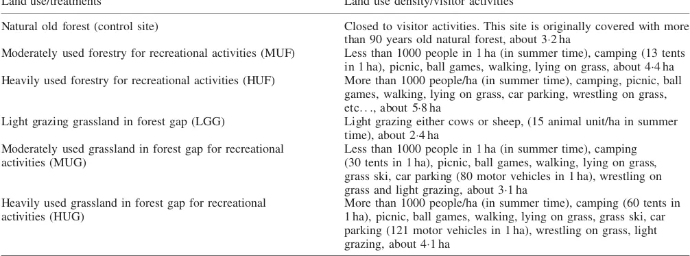
Table I. Description of the land use types in the study area
Land use/treatments Land use density/visitor activities
Natural old forest (control site) Closed to visitor activities. This site is originally covered with more
than 90 years old natural forest, about 32 ha
Moderately used forestry for recreational activities (MUF) Less than 1000 people in 1 ha (in summer time), camping (13 tents in 1 ha), picnic, ball games, walking, lying on grass, about 44 ha Heavily used forestry for recreational activities (HUF) More than 1000 people/ha (in summer time), camping, picnic, ball
games, walking, lying on grass, car parking, wrestling on grass, etc. . ., about 58 ha
Light grazing grassland in forest gap (LGG) Light grazing either cows or sheep, (15 animal unit/ha in summer
time), about 24 ha Moderately used grassland in forest gap for recreational
activities (MUG)
Less than 1000 people in 1 ha (in summer time), camping (30 tents in 1 ha), picnic, ball games, walking, lying on grass, grass ski, car parking (80 motor vehicles in 1 ha), wrestling on grass and light grazing, about 31 ha
Heavily used grassland in forest gap for recreational activities (HUG)
main differences between the treatments (sites). Soil properties according to soil depths were determined using independent samplet-test statistical analysis method. Mean values found for all properties are shown in relevant tables. In addition, correlation analysis was used to assess the relationships among soil properties at different soil depths.
RESULTS AND DISCUSSION
Soil Texture, Water Characteristics, Bulk Density, Particle Density and Total Porosity
Soil depth of 0–5 cm
Soil textures of the experimental sites were loam (control and light grazing in glade (LGG) sites), loamy-sand (moderately used forestry (MUF) and moderately used glade (MUG) sites) and sandy-loam (heavily used forestry (HUF) and heavily used glade (HUG) sites). Mean sand was the highest in the HUG site. Mean sand content slightly increased in the MUF, HUF, LGG, MUG and HUG compared to the control site, and mean clay content increased significantly (p<0044) in the LGG, MUG and HUG sites compared to the control site. Mean silt content decreased significantly (p<0031) in the HUF, LGG, MUG and the HUG sites compared to the control site (Table II). Mean FC decreased significantly (p<0040) in all experimental sites compared to the control site. PAW was significantly lower (p<0009) in all experimental sites compared to the control site. Mean PWP increased significantly (p<0037) in HUF, MUG and HUG sites compared to the control site. Because of the traffic density, SPR increased and total porosity decreased in all experimental sites compared to control site. The significant increase in bulk density (Db) and SPR, and significant decrease in total porosity and SOM possibly affected FC, PWP and PAW values (see Table II). Froehlich and McNabb (1983) and Yu¨ksek (2009) reported that soil compaction has a variable effect on water characteristic of soils.
Soil bulk density (Db) increased significantly (
p<0005) and total porosity decreased significantly (p<0015) in all experimental sites compared to the control site. Soil particle density was significantly higher in HUG site, while it was moderately higher in LGG and MUG sites compared to the control site (Table II).Dband SPR increased with disturbed conditions, and accompanying clay content increase and SOM decrease. Correlation analysis indicated that clay content was positively correlated with PWP,Dband SPR, while negatively correlated with St,KsatandIc. However, St was positively correlated with Ksat and Ic, but negatively correlated with SPR (Table III).
Bulk density and soil compaction are known to vary under the influence of particle size distributions in a soil layer (Tuttleet al., 1988; Carter 1990). The presence of clay and
sand correlated well with higher bulk density and SPR in MUG and HUG sites. If the soil was wetter than FC, it would significantly be compacted regardless of the traffic density number. Yu¨ksek et al., (2008) reported that during the festival season from 28th June to 1st July 2006, 8607 people and 2454 vehicles entered Kafkaso¨r festival area, causing soil compaction.
Soil depth of 5–10 cm
At a soil depth of 5–10 cm, sand content slightly increased in all experimental sites compared to the control site. Silt content decreased significantly (p<0028) in MUG and HUG sites while clay content increased significantly (p<0039) in LGG and HUG sites compared to the control site. According to soil depth, clay content increased significantly (p<0045) in HUG site while it decreased significantly (p<0040) in MUG site compared to the control site (Table II).
Mean FC decreased significantly (p<0039) in all experimental sites compared to the control site. PAW was significantly lower (p<0005), while PWP was signifi-cantly higher (p<0031) in all experimental sites compared to the control site. According to soil depth, FC content decreased significantly (p<0040) in MUF and HUF sites, while PAW decreased significantly (p<0014) in all experimental sites (Table II). Compaction and lower SOM content may have a negative impact on water and air status of the soil in MUF, HUF, MUG and HUG sites. The decrease in the amount of organic materials can be considered as a reason of the decrease of the FC and PAW content in the heavily used sites (such as HUF, MUG and HUG sites), as one goes deeper in the soil. As the amount of organic materials decrease, water holding and available water capacities of the soil decrease as well (Hudson, 1994; Querejetaet al., 2000; Iqbalet al., 2005).
The soil bulk density (Db) increased significantly (p<0003) and total porosity decreased significantly (p<0010) in all experimental sites compared to the control site. Soil particle density was significantly higher in the HUG site compared to the control site (Table II). The main reason of the increase of soil bulk density was the variety and density of visitor activities over the study area. Folk dance, car parking, walking, camping, ball games, other visitor activities and light grazing increased bulk density and caused soil compaction. Serengil and O¨ zhan (2007) reported that heavily trampling significantly increased bulk density in Belgrat conservation forest in Turkey. Troeh and Thompson (1993) reported that ball games and other activities might wear out a good stand of grassland and damage topsoil structure. Soil compacts when pore space is reduced and bulk density is increased (Coder, 2000; Hughes et al., 2001). Therefore, any process that reduces pore space causes soil compaction. Correlations
Copyright#2010 John Wiley & Sons, Ltd. LAND DEGRADATION & DEVELOPMENT,21: 582–590 (2010)
Table II. Selected soil properties in the study area
Soil characteristics Soil depth (cm) Experimental sites
Control (1) MUF (2) HUF (3) LGG (4) MUG (5) HUG (6)
Sand (%) 0–5 6425(492)Aa 6560(492)Aa 6672(492)Aa 6670(589)Aa 6810(615)Aa 7032(645)Aa 5–10 6360(521)Aa 6381(577)Aa 6451(568)Aa 6610(580)Aa 6680(620Aa 6705(620)Aa Clay (%) 0–5 1450(107)Ab 1420(102)Ab 1470(110)Ab 1695(150)Aa 1705(177)Aa 1810(175)Ba 5–10 1510(126)Ac 1496(133)Ac 1528(141)Ac 1725(166)Ab 1560(160)Bc 1912(188)Aa Silt (%) 0–5 2125(169)Aa 2020(152)Aa 1858(171)Bb 1635(145)Ac 1485(120)Bd 1158(105)Be 5–10 2130(180)Aa 2123(162)Aa 2021(132)Aa 1665(180)Aa 1760(148)Aa 1383(132)Ab Field capacity
(FC) (vol%)
0–5 2530(219)Aa 2321(230)Ab 2210(221)Ab 2120(210)Abc 2107(220)Abc 2065(212)Acd 5–10 2466(212)Aa 2032(211)Bb 1970(205)Bb 2016(210)Ab 2005(214)Ab 1997(210)Ab Permanent wilting
point (PWP) (vol%)
0–5 1010(065)Ade 1089(068)Acd 1258(088)Ab 1155(070)Acd 1180(072)Ac 1396(095)Aa 5–10 1043(066)Ae 1137(083)Acd 1278(096)Ab 1150(067)Ac 1245(087)Ab 1451(120)Aa Plant available
water (PAW) (vol%)
0–5 1520(116)Aa 1232(110)Ab 952(088)Acd 965(091)Ac 927(105)Acd 669(058)Ae 5–10 1423(061)Ba 895(056)Bb 692(049)Bcd 866(072)Bb 760(051)Bc 546(045)Bd Particle density
(g cm3) (Dp)
0–5 231(013)Abc 233(015)Abc 230(014)Abc 240(017)Ab 239(015)Ab 255(019)Aa 5–10 226(014)Acd 222(011)Acd 210(012)Be 238(016)Ab 232(013)Abc 264(017)Aa Bulk density (Db)
(g cm3)
0–5 088(004)Ad 102(004)Ac 114(008)Ab 105(009)Ac 120(011)Bb 152(014)Ba 5–10 090(007)Ad 107(008)Ac 120(009)Ab 110(008)Ac 128(014)Ab 166(018)Aa Total porosity (St) (%) 0–5 6190(488)Aa 5622(471)Ab 5043(451)Ac 5625(512)Ab 4979(460)Ac 4057(425)Ad 5–10 5722(515)Aa 5180(498)Bb 4286(461)Bcd 5378(490)Ab 4483(440)Bc 3712(389)Be Saturated hydraulic
conductivity (Ksat) (mm h1)
0–5 5552(423)Aa 3621(371)Ab 2482(170)Ad 2885(317)Ac 1457(155)Ae 877(088)Af 5–10 5088(417)Ba 3016(321)Bb 1588(115)Bd 2511(299)Bc 1088(125)Be 512(055)Bf
Cumulative infiltration (mm)
0–5 485(1398)a 296(1155)b 181(994)d 304(1277)b 204(1024)c 126(966)e
Soil penetration resistance (SPR) (MPa)
0–5 047(004)Bf 068(006)Be 089(009)Bd 064(027)Bc 114(042)Bb 202(043)Ba 5–10 060(008)Ae 126(019)Ac 148(044)Ab 088(031)Ad 142(046)Ab 245(047)Aa pH (1/25 H2O) 0–5 662(030)Aa 660(029)Aa 661(029)Aa 647(019)Aa 643(016)Aa 641(017)Aa 5–10 662(031)Aa 660(030)Aa 662(031)Aa 650(018)Aa 647(015)Aa 645(015)Aa Soil organic matter
(SOM) (%)
0–5 611(025)Ab 488(020)Ac 356(015)Ad 721(044)Aa 512(035)Ac 370(028)Ad 5–10 581(019)Ab 405(017)Bc 213(012)Bd 650(040)Ba 378(027)Bc 220(018)Bd Control, non-trafficked site (control site); MUF, moderately used forestry site; HUF, heavily used forestry site; LGG, light grazing in grassland in forest gap; MUG, moderately used grassland in forest gap; HUG, heavily used grassland in forest gap;N, number of samples (N¼16);Ic, cumulative infiltration (mm/2 h), (N¼9). The values shown in parentheses are standard deviation. Means in the row followed by the same small letter are not significantly different atp005. Means in the column followed by the same capital letter are not significantly different atp005.
ght
#
2010
John
W
ile
y
&
Sons,
Ltd.
LAND
DEGRAD
A
TION
&
DEVELOPM
ENT
,
21
:
582–590
T.
Y
U ¨
KSEK
ET
(Table IV) showed that clay content was positively correlated with FC, while negatively correlated with Dp and St. FC was positively correlated with Ksat and PAW (Table IV).
Saturated Hydraulic Conductivity, Cumulative Infiltration and Soil Penetration Resistance
Soil depth of 0–5 cm
Saturated hydraulic conductivity (Ksat) decreased in MUF, HUF, LGG, MUG and HUG sites and it was significantly (p<0008) lower than that of control site. The values of cumulative infiltration (Ic) were significantly (
p<0004)
lower at the trafficked sites compared to that of the control site. SPR increased significantly (p<0010) in all experimental sites compared to the control site. The highest SPR was measured in HUG site while the lowest was measured in control site (Table II). The number of visitors and the density of visitor activities may lead to an increase in soil bulk density and SPR in the study area. Many researchers express that SPR increases as a result of the increase in the topsoil traffic density (Greaten and Sands, 1980; Craul, 1994; Brady and Weil, 1999). Correlation analysis indicated thatKsatandIcwere negatively correlated withDband SPR (Table III).
Table IV. Pearson correlation coefficients among soil properties at 5–10 cm
Sand Clay Silt FC PWP PAW Dp Db St Ksat SPR pH
FC, field capacity (vol%); PWP, permanent wilting point (vol%); PAW, plant available water (vol%);Dp, particle density (g cm3);Db, bulk density (g cm3); St, total porosity (%),Ksat, saturated hydraulic conductivity (mm h1
);Ic, cumulative infiltration (mm); SPR, soil penetration resistance (MPa), SOM, soil organic matter (%).
Correlation significant atp<005 and 001, respectively.
Correlation significant atp<001.
Table III. Pearson correlation coefficients among soil properties at 0–5 cm
Sand Clay Silt FC PWP PAW Dp Db St Ksat Ic SPR pH
FC, field capacity (vol%); PWP, permanent wilting point (vol%); PAW, plant available water (vol%);Dp, particle density (g cm3);Db, bulk density (g cm3); St, total porosity (%);Ksat, saturated hydraulic conductivity (mm h1);Ic, cumulative infiltration (mm); SPR, soil penetration resistance (MPa); SOM, soil organic matter (%).
Correlation significant atp<005.
Correlation significant atp<001.
Copyright#2010 John Wiley & Sons, Ltd. LAND DEGRADATION & DEVELOPMENT,21: 582–590 (2010)
Soil depth of 5–10 cm
At a soil depth of 5–10 cm, Ksat decreased significantly (p<0005), while SPR increased significantly (p<0007) in all experimental sites compared to the control site (Table II). The highestKsatwas measured in the control site, while the lowestKsatwas measured in HUG site. According to soil depth, Ksat content decreased significantly (p<0015), while SPR increased significantly (p<0026)
026) (Table II). Thus, with an increase in the intensity of visitor activities,Ksatdecreased. Increased bulk density and SPR, and decreased SOM reduced water intake capacity of the soil, hence decreasedKsatand infiltration. According to the correlation analysis there was a significant negative correlation betweenKsatandDband SPR (Table III).
The intensity of visitor activities compacts the soil to considerable depths and significant changes occur in soil strength and saturated hydraulic conductivity because of traffic. The impacts were the greatest in the surface layer (Froehlich and McNabb, 1983). Soil compaction caused by human trampling, wheel traffic or animal grazing can destroy large pores and therefore reduce saturated or near-saturated hydraulic conductivity (Drewry and Paton, 2005). After the soil compacted, soil infiltrability and permeability decrease. Similarly, if the compaction is accomplished with a proper moisture control, the movement of capillary water is minimized (Gent and Ballard, 1985).
Soil Organic Matter and pH
Soil depth of 0–5 cm
SOM content decreased in MUF, HUF, MUG and HUG sites, and it was significantly (p<0009) lower than that of control site. pH content slightly decreased in all exper-imental sites compared to the control site, while it was non-significant (Table II). Correlation analysis indicated that SOM was positively correlated with FC, St, Ksat and Ic, while negatively correlated with Dp, Db and SPR (Table III).
Soil depth of 5–10 cm
SOM content decreased significantly (p<0005) in the MUF, HUF, MUG and HUG sites compared to the control site. pH content slightly decreased in MUF, LGG, MUG and HUG sites, while it was non-significant (Table II). Accord-ing to soil depth, SOM content decreased significantly (p<0008) in all experimental sites compared to the control site. pH content slightly increased in the HUF, LGG, MUG and HUG sites, while it was non-significant (Table II). Correlations indicated that SOM was positively correlated to FC, PAW, St andKsat, while negatively correlated withDb and SPR (Table IV).
It is well known that vegetative residuals are one of the major sources of SOM (Burkeet al., 1987). The intensity and density of visitor activities damaged surface soil
properties. Moreover, the changing properties of the soil may directly or indirectly affect the decrease of herbaceous cover.
SOM significantly decreased in MUF, HUF, MUG and HUG sites but the greatest decrease was observed in HUG site in the study area. Different studies have shown that removing aboveground biomass (Staaf and Olsson, 1991) and land use change (Troitin˜o et al., 2007) affect SOM content. Jim (1987) studied camping impacts on vegetation and soil in a Hong Kong country park. He found that trampling resulted in loss of vegetation cover, and reduction in plant height and root biomass. Species composition shifted in response to increasing usage towards domination by a few trampling-resistant grasses (monocots) at the expense of sensitive woody dicots. The loss of vegetation and litter cover contributed to soil compaction, increases in bulk density, penetration resistance and bare soil cover, and decreases in void ratio and organic matter content. Structural damage led to reduction in water storage and infiltration rate. An important consequence of increased bulk density and SPR and decreased SOM decreased water intake capacity of the soil, hence decreasedKsat and cumulative infiltration.
CONCLUSIONS AND RECOMMENDATIONS
In this research, we tried to explain the long-term impacts of visitors’ activities that are carried out for many years (more than 60 years) on the surface soil properties in Kafkaso¨r protected area in both forest and glade areas, which are converted from natural forest. We determined that the intensity of visitor activities had a negative impact on surface soil physical and hydro-physical properties in different land use types in Kafkaso¨r protected area. Significant changes occurred in mean silt ratio, soil water characteristics (FC, PWP and PAW), bulk density, total porosity, SPR, SOM, cumulative infiltration and saturated hydraulic conductivity because of traffic density in the study area. The impacts were the greatest in the heavily trafficked-site and, to a lesser degree, in moderately trafficked in the study area. This study has also shown significant changes in soil properties following conversion of natural forest into glade. The grazing in glade had more significant effect on soil properties than visitor activities in forest.
protected site. Except festival days, it is free of charge to enter this protected area, and any visitor can camp at any part of this area without asking for permission, which leads to soil and vegetation degradation. We can conclude that in Kafkaso¨r protected area the land is used quite heavily, especially in festival days. Consequently, this leads to destruction of not only surface soil properties but also vegetation structure and plant growth.
The principles of management in Kafkaso¨r protected area should be revised, and use of this area without a plan should be stopped as soon as possible. First of all, the ownership problem of this area should be solved. Afterwards, a Kafkaso¨r protected area planning and management office should be established. The manager of this office and his team who are specialized in protected area planning and management should prepare an acceptable and sustainable land use plan for this area. This management plan should bring solution to all land use problems of Kafkaso¨r protected area. In order to achieve this, the planners should correctly analyse land use problems and their effects on soil and vegetation. Visitor activities should be categorized and the most suitable places should be planned for each recreational activity. Some alternative places could be planned to suit each type of visitor activity. When activity areas are damaged, they may be closed to visitors for rehabilitation works. When the impacts are avoidable or unacceptable, the managers should choose and implement one or more corrective actions. A principal challenge of protected area management is determining what action(s) will be most effective in avoiding or minimizing visitors’ impacts. Long-term utilization of heavily trafficked sites increases the damage of topsoil physical and hydraulic physical proper-ties. Therefore, avoiding long-term utilization of study area may decrease the damages. Rehabilitation works (such as mulching, re-establishing drainage canals, etc. . .) in heavily
used sites where soil properties are drastically degraded would be regenerated for protecting of the ecosystem. Most protected areas internationally operate under similar requirements success in achieving an appropriate balance between recreation provision and resource protection requires professional management of park natural resources and visitors’ use. Managers should have the ability to assess visitors’ impacts and determine their acceptability with respect to park management objectives.
REFERENCES
Anonymous. 1993. Available land properties of city of Artvin. Ankara: Publications of general offices of villages foundation, Report No. 08 [in Turkish].
Anonymous. 2005. Central chieftaincy planning project of Artvin. Artvin: Republic of Turkey Ministry of Environment and Forestry, District of Artvin Forestry, pp. 32-139 [in Turkish].
Anonymous. 2007. Some climatic data of Artvin city in the year between 1970-2007. Ankara: Turkish State Meteorological Service, pp. 1-11 [in Turkish].
Blake GR, Hartge KH. 1986. Bulk density. InMethods of Soil Analysis. Part
I. Physical and Mineralogical Methods, Agronomy Monograph no. 9, 2nd edn, Miller AL, Keeney RH (eds). ASA and SSSA: Madison; 363–374.
Bouwer H. 1986. Intake rate: cylinder infiltrometer. InMethods of Soil
Analysis. Part I. Physical and Mineralogical Methods, Agronomy Mono-graph no. 9, 2nd edn, Klute A (ed.). ASA and SSSA: Madison; 825–844. Bouyoucos G. 1962. Hidrometer method improved for making particle size
analysis of soils.Agronomy Journal54: 464–465.
Bradford JM. 1986. Penetrability. InMethods of How farmers Assess Soil
Health and Quality. Journal Soil Water Consoil Analysis. Part 1. Agr-onomy Monograph no. 9, 2nd edn, Klute A (ed.). ASA and SSSA: Madison, WI; 229–236.
Brady NC, Weil R. 1999.The nature and properties of soils. Prentice Hall
Publishing: Engelwood Cliffs, NJ.
Burke IC, Reiners WA, Sturges DL, Matson PA. 1987. Herbicide treatment effects on properties of mountain big sagebrush soils after fourteen years. Soil Science Society of America Journal51: 1337–1343.
Carter MR. 1990. Relationship of strength properties to bulk density and
macro porosity in cultivated loamy sand to loam soils.Soil and Tillage
Research5: 257–268.
Cassel DK, Nielsen DR. 1986. Field capacity and available water capacity. InMethods of Soil Analysis, Part 1. Physical and Mineralogical Methods-Agronomy Monograph no. 9, 2nd edn, Klute A (ed.). ASA and SSSA: Madison, WI; 901–926.
Coder KD. 2000. Defining Soil Compaction: Sites & Trees. University of Georgia, Warnell School of Forest Resources Extension Publication, for 00-4.
Cole DN. 1987. Research on soil and vegetation in wilderness: a
state-of-knowledge review.Proceedings-National Wilderness Research
Confer-ence. State of Knowledge, Future Directions: Fort Collins, CO; 135–177.
Craul PJ. 1994. Soil compaction on heavily used sites.Journal of
Arbor-iculture20: 69–74.
Daum DR. 1996. Soil compaction and conservation tillage. Pennstate University, College of Agricultural Sciences Cooperative Extension, Conservation Tillage Series No.3.
Drewry JJ, Paton RJ. 2005. Soil physical quality under cattle grazing of a
winter-fed brassica crop.Australian Journal of Soil Research43: 525–
531.
Eminag˘aog˘lu O¨ , Ans¸in R. 2005. The flora of Cerattepe, Meydanlar,
Demirci, Gavur Creek and near environment in Artvin. Journal of
Istanbul University, Faculty of Forestry A55: 32–46.
Flint A, Flint LE. 2002. Particle density. InMethods of Soil Analysis, Part 4-Physical Methods, Dane JH, Topp GC (eds). SSSA Book Series No. 5. Soil Science Society of America: Madison, WI; 229–240.
Froehlich HA, McNabb DH. 1983. Soil wetness at the time of skidding and
the level of in Pacific Northwest forests. Trafficking Dominate the
Compaction Process in Boreal Forest Soils and Treatment Impacts Conference, University of Tennessee, Knoxville, TN; 159–192. Gent JA, Ballard R. 1985. Impact of intensive forest management practices
on the bulk density of lower Coastal Plain and Piedmont soils.Southern
Journal of Applied Forestry9: 40–44.
Greaten EL, Sands R. 1980. Compaction of forest soils, a review.Australian
Journal of Soil Research18: 163–189.
Grieve IC. 2001. Human impacts on soil properties and their implications
for the sensitivity of soil systems in Scotland.Catena42: 361–374.
Grossman RB, Reinsch TG. 2002. The solid phase, bulk density and linear extensibility, InMethods of Soil Analysis, Part 4- Physical Methods, Dane JH, Topp GC (eds). SSSA Book Series No.5. Soil Science Society of America: Madison, WI; 201–228.
Hudson BD. 1994. Soil organic matter and available water capacity.Journal
of Soil and Water Conservation49: 189–193.
Hughes JD, Moncrief JF, Voorhees WB, Swan JB. 2001. Soil compaction, causes, effects and control (accessed on 2nd March 2007). http://www.ex-tension.umn.edu/distribution/cropsystems/DC3115.html
Iqbal J, Thomasson JA, Jenkins JN, Owens PR, Whisler FD. 2005. Spatial
variability analysis of soil physical properties of alluvial soils. Soil
Science Society of America Journal69: 1338–1350.
Copyright#2010 John Wiley & Sons, Ltd. LAND DEGRADATION & DEVELOPMENT,21: 582–590 (2010)
Jim CY. 1987. Camping impacts on vegetation and soil in a Hong Kong
country park.Applied Geography7: 317–332.
Karaoz O. 1989. Analyze methods of some chemical soil properties (pH, carbonates, salinity, organic matter, total nitrogen, available phosphorus). Review of the Faculty of Forestry, University of Istanbul 39, 64-82 [in Turkish].
Kerbiriou C, Leviol I, Jiguet F, Julliard R. 2008. The impact of human
frequentation on coastal vegetation in a biosphere reserve.Journal of
Environmental Management88: 715–728.
Klute A. 1986. Water retention. In Methods of Soil Analysis, Part 1:
Physical and Mineralogical Methods, Agronomy Monograph no. 9, 2nd edn, Klute A (ed.). ASA and SSSA: Madison, WI; 635–662. Klute A, Dirksen C. 1986. Hydraulic conductivity and diffusivity. In
Methods of Soil Analysis, Part 1. Physical and Mineralogical Methods-Agronomy Monograph no. 9, 2nd edn, Klute A (ed.). ASA and SSSA: Madison, WI; 687–734.
Nelson DW, Sommers LE. 1996. Total carbon, organic carbon and organic
matter, InMethods of Soil Analysis, Part. 3, 3rd edn, Sparks DL, Page
AL, Helmke PA, Loeppert RH, Soltanpour PN, Tabatabai MA, Johnson CT, Sumner ME (eds). SSSA Book Series No. 5. Madison; 961–1010. Querejeta JI, Rolda´n A, Albaladejo J, Castillo V. 2000. Soil physical properties and moisture content affected by site preparation in the
afforestation of a semiarid rangeland.Soil Science Society of America
Journal64: 2087–2096.
Serengil Y, O¨ zhan S. 2007. Recreational use impacts on hydrological
properties of a deciduous forest ecosystem in Turkey.Ekolo´gia
(Bra-tislava)26: 90–98.
Short JR, Fanning DS, Mc Intosh MS, Foss JE, Patterson JC, 1986. Soils of
the Mall in Washington, D.C: I. Statistical summary of properties.Soil
Science Society America Journal50: 699–704.
Staaf H, Olsson BA. 1991. Acidity in four coniferous forest soils after
different harvesting regimes of logging slash.Scandinavian Journal of
Forest Research6: 19–29.
Troeh FR, Thompson LM, 1993.Soils and Soil Fertility. Oxford University
Press: NY.
Troitin˜o F, Gil-Sotres F, Leiro´s MC, Trasar-Cepeda C, Seoane S. 2007. Effect of land use on some soil properties related to the risk of loss of soil
phosphorus.Land Degradation & Development19: 21–35.
Tuttle CL, Golden MS, Meldahl RS. 1988. Soil compaction effects onPinus
Taedaestablishment from seed and early growth.Canadian Journal of Forest Research18: 628–632.
Vimmerstadt J, Scoles F, Brown J, Schmittgen M. 1982. Effects of use pattern, cover, soil drainage class and overwinter changes on rain
infiltration on campsites.Journal of Environmental Quality11: 25–28.
Yu¨ksek T. 2009. The effect of visitor activities on surface soil environmental conditions and aboveground herbaceous biomass in Ayder Natural Park. Clean37: 170–175.
Yu¨ksek T, Cengiz T, Yu¨ksek F. 2008. The evaluation of festival activities in the point of conservation and usage in natural areas: Kafkaso¨r culture, art
and tourism festival.Ekoloji17: 37–45 [in Turkish].
Yu¨ksek T, O¨ lmez Z. 2002. A general assessment of climate, soil
structure, forest areas, growing stock and some forestry applications
of Artvin region. Journal of Artvin Faculty of Forestry1: 50–62 [in