DOCUMENTATION OF HERITAGE STRUCTURES THROUGH
GEO-CROWDSOURCING AND WEB-MAPPING
H. K. Dhonju a, W. Xiao b, B. Shakya a, J. P. Mills b, V. Sarhosis b
a International Centre for Integrated Mountain Development (ICIMOD), Kathmandu, Nepal - [email protected] b School of Engineering, NEOlab, Newcastle University, Newcastle upon Tyne, UK - [email protected]
Commission IV, WG IV/4
KEY WORDS: Crowdsourcing, Documentation, Tangible Heritage, Visualization, Volunteered Geographic Information, Web-mapping
ABSTRACT:
Heritage documentation has become increasingly urgent due to both natural impacts and human influences. The documentation of countless heritage sites around the globe is a massive project that requires significant amounts of financial and labour resources. With the concepts of volunteered geographic information (VGI) and citizen science, heritage data such as digital photographs can be collected through online crowd participation. Whilst photographs are not strictly geographic data, they can be geo-tagged by the participants. They can also be automatically geo-referenced into a global coordinate system if collected via mobile phones which are now ubiquitous. With the assistance of web-mapping, an online geo-crowdsourcing platform has been developed to collect and display heritage structure photographs. Details of platform development are presented in this paper. The prototype is demonstrated with several heritage examples. Potential applications and advancements are discussed.
1. INTRODUCTION
Tangible heritage is a vital part of people’s lives. It usually has both spiritual and economical values to local people. To protect and pass heritage structures to future generations, preservation, conservation and restoration are increasingly important. This is especially the case in developing countries where heritage structures are not well preserved and often at risk to both natural disaster and human behaviour.
Heritage structures are usually documented by experts using professional instruments. Laser scanners are now common tools for such tasks as data acquisition is rapid and data quality is high in terms of geometric accuracy and completeness (El-Hakim et al., 2004). However, it is suitable for small scale documentation but not large scale, for instance at a city-wide level or even a whole country. Moreover, high-end laser scanners are normally expensive and hence may not be employed for large scale projects. Another popular approach is image-based heritage documentation (Remondino and El-Hakim, 2006), which has appealing advantages over laser scanning, such as portability, low cost, photorealism, ubiquity. With recent developments in photogrammetric 3D reconstruction, such as structure from motion and dense image matching, the quality of photogrammetric models is adequate for documentation purposes, even for geometric extraction. The feasibility of low-cost photogrammetry for heritage documentation is therefore of great value for developing countries.
The documentation and conservation of tangible heritage is facing various challenges. One major difficulty is the massive distribution of heritage structures. Less than one thousand of them are listed as UNESCO world heritage sites which are then preserved to a recognised standard. The majority are not so significant worldwide, and are thus not listed, but hold great value to local people. Sites may consist of a single structure,
such as a temple, monument or statue, in a remote area. Huge resources are needed to identify, locate, and document such unattended heritage treasures. Another challenge lies in the deterioration of such heritage structures. Depending on the construction material, some structures suffer from rapid decay, especially in a changing climate environment. These heritage structures need to be regularly monitored and maintained. This means that a one-time documentation will not fulfil the preservation task. Instead, repeat observations are sought.
To effectively record and preserve heritage structures at a large scale on a regular basis, appropriate data acquisition techniques are required. In such a scenario, individual effort is not sufficient to survey all of the world’s scattered, hidden or uncaptured heritage structures. Community or citizen participation, consisting of heritage digitization and documentation, will therefore contribute significantly to heritage preservation (Tiwari, 2013). In this context, open crowdsourcing is an ideal option to capture data of heritage structures from various geo-locations. Nowadays, mobile phones with in-built cameras have become ubiquitous. Mobile phone enabled online crowdsourcing can therefore help to collate massive photo albums from the global population and, more importantly, from citizens with local knowledge of heritage which can be both protected and exploited.
explained the basic technology. Brovelli et al. (2016) discussed public participation or volunteered geographic information via mobile applications. Most current geo-crowdsourcing projects are focused on explicit geospatial data which can be integrated into a 2D base map. However, not all crowdsourced data can be processed in this way.
As for crowdsourcing for heritage documentation, one existing project is Rekrei, formally known as Project Mosul1. Images are uploaded through the website by volunteer participants, where they are sorted and processed to reconstruct a 3D model. A 2D map indicates the locations and number of mapped heritage sties, but no data or results are visulised (Vincent et al., 2015). Another heritage related crowdsourcing project is Curious Travellers2, aiming at the documentation of archaeological sites, monuments and heritage at risk. However, no webmapping technique is applied to enhance the geo-crowdsourcing process.
This paper reports the development of a geo-crowdsourcing platform, empowered by web-mapping for data visualisation, targeting tangible heritage data sources. These data are mostly geo-tagged images, which are not strictly spatial data and hence need to be handled differently instead of projecting them onto the basic map. Images are categorised and stored for documentation and 3D modelling, and visualized for ranking and visual inspection purposes.
2. GEO-CROWDSOURCING AND WEB MAPPING
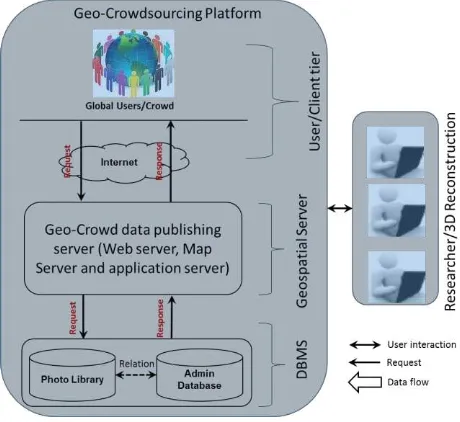
To investigate the potential of geo-enabled photo crowdsourcing of historically and culturally important heritage structures, a prototype platform was developed to facilitate the easy uploading and visualisation of imagery from crowd users. The platform consists of three main components: 1) Web interface as a presentation and user interaction layer from where crowd users are allowed to upload photos, including web mapping of geolocations via geographical information; 2) Geospatial and photo server through which photos and geolocations of photos are served and processed; and 3) Database management system server in which crowd sourced information and the photo library are stored and managed. Figure 1 shows the general system architecture.
The platform is targeted at general crowdsource users with the aim of bringing them all together regardless of their background, skills, knowledge of heritage or their location of interest and residence. It is anticipated that data will be gathered from users and information provided to the public anytime and anywhere.
Through this platform, a user can upload a series of captured photos of the heritage structure and create a unique photo album with textual information. Further information, such as degree of damage to a structure, can also be collected by the platform. The photos can be examined by the platform itself and by the public users. Users are also able to check their own photo albums. Albums are constantly updated and photos are ranked. Photos from multiple users can be merged, either by the user or by the geo-location. In the feedback process, the user is allowed to submit additional photos as per need. This process of collecting feedback and improving photo ranking is repeated. The whole concept and process flowline is illustrated in Figure 2.
1 https://rekrei.org/
2 http://www.visualisingheritage.org
Figure 2. Data flow of the crowdsourcing platform
3. SYSTEM DEVELOPMENT
The system prototype was developed considering various aspects such as user interactivity and user friendliness, helping define essential features for general crowd source users. The whole system has been designed and developed under free and open source systems. The system consists of three servers: web server, map server and database server. To understand the system flow and operational functions of the system, it is important to study the overall use case for effective user interactivity.
3.1 Use case diagram
Any public citizen can be a crowdsource user, but one has to register first. A registered user needs to login into the system to interact with the geo-crowdsource platform. The various functionalities and the sequence of operation for the user are illustrated in the use case diagram depicted in Figure 3.
Figure 3. Use case diagram (UCD)
Users have access to the system through a compatible browser with various functions and tasks. These include creation of a new album, viewing an album list, searching an album, viewing an album’s detail and photos, and album management, including a voting system for photo filtering.
The detailed procedure as a user is as follows:
1. Register user for the first time and then login into the system;
2. Create a photo album for a structure: while creating an album, the system will ask for attribute details of the structure such as location, and status (e.g. No damage, Minor crack, Partial damage, Full damage);
3. Upload the photos into the album: during photo upload, the user is allowed to select or deselect from the list of photos for good quality photo filtering at the user level;
4. The selected photos for upload are filtered / screened automatically by the system to ensure the quality of the photo (e.g. size and resolution of the photo). Accepted photos are stored in the photo album database;
5. Uploaded photos in the album are made available to the wider public domain via a service-oriented architecture (SOA) based photo viewer and tool for photo filtering by public voting;
6. The photo ranking will be sent to the user, and the user can receive feedback on the images, rankings, and textual information.
3.2 Servers
The database server takes care of data storage and management, the map server is in charge of rendering maps, and the web server is responsible for providing the WWW service. Two open source spatial database servers: MySQL and PostgreSQL/PostGIS are popular for database management systems (DBMS). Although both database systems are very powerful in spatial support systems, PostgreSQL/PostGIS seems to have a larger range of spatial functionality (Cross Compare, 2012) and is used by many recent Web GIS solutions (Anderson et al., 2008; Evans and Sabel, 2012; Greene et al., 2007; MacEachren et al., 2008; Toutant et al., 2011). This geodatabase server was therefore chosen for implementation. The implemented entity relationship diagram for the database is presented in Figure 4.
Figure 4. Entity Relationship Diagram (ERD)
The map server bridges the database server and web browsers, making it possible to access and display spatially enabled data as a map layer and enable querying and spatial analysis of displayed data (Anderson and Deoliveira, 2007). MapServer and GeoServer are both similar types of open source map servers. GeoServer was chosen due to its ease of administration to aid in testing and system development. A PHP-based platform, which provides several web services used by the web application and the mobile clients, was chosen for server side scripting. The database stores and manages all the tasks defined in the system through the web system. All crowd sourced albums and photos are associated with geographical information that is used for web mapping and visualization.
3.3 Web Platform
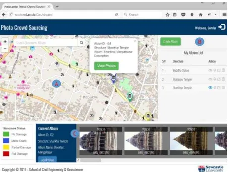
The system thereby provides two different aspects for crowd users and seekers. The users’ area enables upload of photos for specific structures in different locations and voting to prioritize suitable photos for further processing. The seekers’ area includes an overview of all geo-crowdsourced photo albums that have already been mapped and created, and which can be easily tracked. The prototype of the web platform3 is shown in Figure 5.
Figure 5. Web interface for crowdsourcing and visualisation
The overall web platform interface consists of three main elements: map (A), album management (B) and photo viewer (C). By default, all crowd sourced albums are tagged onto the map and all registered users can visualize all submitted photo albums on the map. Whilst creating a photo album, the geo-location of the album can be set independently from the current location. Moreover, the system allows any user to search, view short details and view photos in the photo viewer of each album. Furthermore, a user can vote for any particular photo of interest of the album under observation. More specifically, the owner of the album is allowed to manage albums, such as editing the album’s details, delete unused albums and delete photos if needed. Figure 6 shows the view of another crowdsourcing user interacting with a photo album of the previous user (Figure 5) and casting a vote on the images. The total number of votes is shown on top of each image. The vote can also be removed if required.
Figure 6. Voting illustration from a second user
3 http://soch.ncl.ac.uk
There are several improvements planned for this web platform, including server side processing where photo filtering can be performed by using machine learning techniques to sort out heterogeneous photos. Later, photo albums will be processed server side by a 3D modelling module which converts 2D images to 3D models via photogrammetry. The process will be extending to trusted and experienced web administrative domain expert users to ensure high quality and scalability to automatic 3D reconstruction. In addition, a virtual 3D library will be developed to host and visualise 3D models. All the resources (crowd sourced and generated data) will be made available to the general public and archaeological archives for relevant uses. Furthermore, the platform will be extended with similar web functionalities to mobile clients which can cater to larger crowdsource users who prefer to use, or only have access to, mobile phones. This mobile client application will help to collect numerous photo albums across the world.
4. DISCUSSION
Crowdsourced images are simply screened by the platform, thus security issues have to be considered during the further development in case of abuse. Also, users should be able to choose whether their photo albums are visible to the public or only other registered users.
2D geo-tagged images are collected and visualised on the platform. They are located on the map based on the tagged geolocation. Multiple albums may present the same heritage structure but have slightly different geolocations due to imperfect geo-localisation. A location buffer is therefore set to merge albums that are located sufficiently close to one another. A possible way to improve this is image matching. Features are extracted from each of the albums that are close to each other, then they can be merged if there are sufficiently similar image features.
Currently, the platform only collects data from registered users in a passive way. When there are sufficient images collected, they will form a database which can be used for image retrieval so that additional images, or even video, can be extracted from online databases such as Flickr. In this way, the database of the platform will be able to grow organically. It will then be possible to derive more useful information.
Apart from 2D images other types of heritage related data, both tangible and intangible, can also be collected. Video is often a better form of data to attract attention from a wider audience. Textual information, such as background stories linked to a specific heritage structure, will help the public to better understand the value of their heritage. Most of the time, there is intangible culture attached to tangible heritage, especially for spiritual structures.
Another common usage of 2D images is to build a 3D model of the structure using state-of-the-art photogrammetric technology. Data can be processed automatically at the server side, and then 3D models can be visualised on the platform. Needless to say, 3D modelling has become a common practise for heritage documentation. 3D models can provide an immersive and visual experience when used for virtual tourism.
detailed geometric model for assessment and analysis purposes. Moreover, multi-temporal data can be investigated to analyse the evolution of a heritage structure through time.
Another potential use of the platform is community engagement. A local community is able to contribute to the data collection, and they can benefit throughout the process of sharing, for instance in discovering unrevealed recordings or histories of their indigenous heritage. This platform will help to build up an online community to promote local heritage to younger generations and people in the wider world.
It is envisaged that such a geo-crowdsourcing platform can be used for other purposes such as disaster response. Any data with geo-location information can be shared and visualised via web-mapping. In the case of natural hazards, such as flooding or landslides, timely crowdsourced data can well serve as useful information for better decision making. Public responses to hazards can be collected and analysed to help mitigate the risks and impacts (Goodchild and Glennon, 2010).
5. CONCLUSION
A geo-crowdsourcing platform has been developed which will enable public engagement and volunteered Geographic Information (VGI) collection for tangible heritage documentation. It also allows participative mapping and interaction by adding new photos, identifying heritage locations and structural status, etc. Users will be able to use mobile phones to interact with the platform separately from the web interface, which makes the platform ubiquitous. The web mapping platform can be accessible worldwide, is highly dynamic and constantly updated. The collated photos can be used for visual inspection and 3D reconstruction, in which case a 3D model can be generated and visualized on the platform. Users from around the world will be able to contribute to and benefit from the platform, which can be a web-based resource sharing hub for both educational and research purposes.
Further developments are planned for the platform to host other types of heritage data, such as text and video, which can represent both tangible and intangible heritage. Advanced image processing and retrieval methods are to be introduced to improve the image ranking, visualisation and categorisation. 3D models will be generated from the imagery and visualised on the platform.
ACKNOWLEDGEMENTS
The work has been conducted as part of the ‘Disaster Risk Reduction of Heritage Structures in Nepal’ project4 supported by the UK Engineering and Physical Sciences Research Council (EPSRC).
REFERENCES
Alt, F., Shirazi, A.S., Schmidt, A., Kramer, U. and Nawaz, Z., 2010. Location-based crowdsourcing: extending crowdsourcing to the real world. In Nordic Conference on Human-Computer
Interaction: Extending Boundaries. pp. 13–22.
Anderson, B. and Deoliveira, J., 2007. WMS performance tests! Mapserver & Geoserver, Free and Open Source Software for Geospatial.
4 http://research.ncl.ac.uk/heritageconservation/
Anderson, J.E., Plourde, L.C., Martin, M.E., Braswell, B.H., Smith, M.-L., Dubayah, R.O., Hofton, M.A. and Blair, J.B., 2008. Integrating waveform lidar with hyperspectral imagery for inventory of a northern temperate forest. Remote Sensing of
Environment, 112(4), pp.1856–1870.
Brovelli, M.A., Minghini, M. and Zamboni, G., 2016. Public participation in GIS via mobile applications. ISPRS Journal of
Photogrammetry and Remote Sensing, 114, pp.306–315.
Cross Compare, S., 2012. Server 2008 Spatial, PostgreSQL/PostGIS 1.3-1.4, MySQL 5-6, Retrieved 7 May 2017. Available at: http://www.bostongis.com.
El-Hakim, S.F., Beraldin, J.-A., Picard, M. and Godin, G., 2004. Detailed 3D reconstruction of large-scale heritage sites with integrated techniques. IEEE Computer Graphics and
Applications, 24(3), pp.21–29.
Evans, B. and Sabel, C.E., 2012. Open-Source web-based geographical information system for health exposure assessment. International journal of health geographics, 11(1), p.2.
Goodchild, M.F., 2007. Citizens as sensors: the world of volunteered geography. GeoJournal, 69(4), pp.211–221.
Goodchild, M.F. and Glennon, J.A., 2010. Crowdsourcing geographic information for disaster response: a research frontier.
International Journal of Digital Earth, 3(3), pp.231–241.
Greene, S.L., Minoura, T., Steiner, J.J. and Pentacost, G., 2007. WebGRMS: Prototype software for web-based mapping of biological collections. Biodiversity & Conservation, 16(9), p.2611.
Heipke, C., 2010. Crowdsourcing geospatial data. ISPRS Journal of Photogrammetry and Remote Sensing, 65(6), pp.550–557.
MacEachren, A.M., Crawford, S., Akella, M. and Lengerich, G., 2008. Design and implementation of a model, web-based, GIS-enabled cancer atlas. The Cartographic Journal, 45(4), pp.246– 260.
Remondino, F. and El-Hakim, S., 2006. Image-based 3D modelling: a review. The Photogrammetric Record, 21(115), pp.269–291.
Tiwari, S.R., 2013. Community participation in heritage affairs.
In International Symposium on Revisiting Kathmandu,
Safegurding Living Urban Heritage. pp. 189–196.
Toutant, S., Gosselin, P., Bélanger, D., Bustinza, R. and Rivest, S., 2011. An open source web application for the surveillance and prevention of the impacts on public health of extreme meteorological events: the SUPREME system. International journal of health geographics, 10(1), p.39.