and Early Warning System
Teuku Faisal Fathani, Dwikorita Karnawati, and Wahyu Wilopo
Abstract
Areas prone to mass movement are widespread in Indonesia. The potential for landslide disasters in several regions is controlled by the geotechnical and geological conditions and triggered by high intensity rainfall and/or earthquake activity. The vulnerability to landslides is made worse by intensive land-use development. The urgent issues to be addressed are the dense populations residing in areas prone to mass movement and the failure to relocate the local people to safer areas for socio-economic reasons. Therefore, landslide monitoring, prediction, and early warning systems are urgently required to guarantee the safety of communities living in such areas. A long running and sustainable community-based landslide monitoring and early warning system (EWS) has been developed in Indonesia, with establishment of collaboration among the local government, universities, private sectors, NGOs, and the disaster management community. The main purpose of the program is to establish a strategic approach for disaster risk reduction through the implementation of information flow (for warning levels) and order/command systems (for evacuation). These activities have already met the community needs, helped save lives, and continued to obtain solid community support. In order to extend the effort, further challenges are to expand the project coverage, and propose more effective landslide monitoring, early warning, analysis, and visualization. In addition, the capabilities in socio-economic risk assessment need to be expedited to help identify those most at risk within the community. This paper describes the achievements and the current activities of the IPL Project (IPL-158)“Development of Community-based Landslide Early Warning System”.
Keywords
Landslide monitoring sensors Information flow Command system Community empowerment
Introduction
As a basis for landslide mitigation, the implementation of preventive measures usually focuses on avoiding slope failure, diverting the moving mass away from vulnerable elements, or building reinforcement to protect the threatened elements. However, the importance of early warning systems may rise if landslide mass stabilizing action is considered expensive in financial and/or environmental terms. The implementation of early warning systems may, at least, avoid damage and the loss of human lives (Corominas et al.2005). T.F. Fathani (*)
Department of Civil and Environmental Engineering, Universitas Gadjah Mada, Jalan Grafika No. 2, Yogyakarta 55281, Indonesia e-mail:[email protected]
D. KarnawatiW. Wilopo
Department of Geological Engineering, Universitas Gadjah Mada, Jalan Grafika No. 2, Yogyakarta 55281, Indonesia
e-mail:[email protected];[email protected]
K. Sassa et al. (eds.),Landslide Science for a Safer Geoenvironment, Vol. 2,
DOI 10.1007/978-3-319-05050-8_87,#Springer International Publishing Switzerland 2014
Ideally, zones with a high susceptibility and landslide risk should be prevented from being developed. Unfortunately, quite often the susceptible particular zone has been developed as a dense settlement of housing and infrastruc-ture areas and the relocation of people living in this area to a safer zone cannot be conducted due to some socio-economic constraints. Thus, the development of a landslide warning system becomes very critical to protect the people living in the landslide-prone areas (Anderson et al.2011; Halcombe et al.2012).
In order to guarantee the effectiveness of the landslide early warning system, the developed system should be simple to operate and appropriately installed in the most suitable sites. Consequently, this system should incorporate both technical and social approaches. The determination of early warning criteria is considered as one of several involvements in a technical approach (Fathani et al.2011; Fathani and Karnawati2010).
The application of the most appropriate and adaptive technology for an early warning system is considered crucial to reduce the risk of landslide disasters. Unfortunately, the effectiveness in implementing an early warning system cannot be guaranteed due to inadequate consideration of the social, cultural, and economic conditions. Accordingly, the need to integrate social considerations into the technical system should be addressed in order to assure the effective-ness in the implementation of such an approach.
Development of the Technical System
The technical system to support landslide disaster risk reduction was developed by Fathani and Karnawati (2012), and consists of several technical components such as instruments for a landslide early warning system recommended by Fathani et al. (2008) and also Fathani and Karnawati (2010), supported by the smart-grid for landslide hazard communication, monitoring and early warning developed by Karnawati et al. (2011b,2012).
Faculty of Engineering, Universitas Gadjah Mada Indonesia has developed simple and low-cost equipment for landslide monitoring and early warning since 2007. Initially, two types of simple extensometers and rain gauge were installed at several pilot areas in Central Java and East Java Provinces. The first type of extensometer is a handmade manual reading extensometer and the other type is an automatic extensometer for monitoring ground surface movement. Both types of extensometers, coupled with an Automatic Rainfall Recorder (ARR), are connected to the alarm system to directly warn the local community to take necessary actions in dealing with potential landslide disasters (Fathani et al.2008).
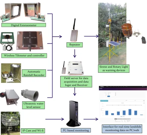
In line with the installation of simple monitoring equipment, the Asian Joint Research Project for Early Warning of Landslides has conducted a field survey to support the installation of real-time landslide monitoring equipment. A pilot area has been established in the Banjarnegara Regency, Central Java Province. This moni-toring system presents the results of real-time measurement by using long-span extensometers, a raingauge, and pore pressure sensors, with monitoring of the scene by IP camera. The real-time monitoring equipment consists of outdoor and indoor units. The outdoor unit is fixed on a center pole and consists of a fieldserver, two extensometers, a raingauge, an IP camera and water pressure sensor. The fieldserver is a sensing device with a real-time online data display system which gathers the data from multiple sensors and shows it in a webserver.
Since 2012, a real-time landslide monitoring and early warning has been developed by Universitas Gadjah Mada. The system comprises several sensors: namely a digital extensometer, wireless tiltmeter, inclinometer, Automatic Rainfall Recorder (ARR), ultrasonic water level sensor and an IP Camera, and other sensors can be added, such as pore water pressure and inclinometer sensors.
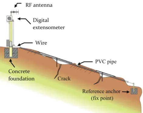
Extensometers are used to measure any change in the distance between two fixed points across the crack and are attached to the soil slope to be monitored. The system adopts the auto-monitoring and event trigger method. When the variations occur, the signal of 1 mm displacement triggers the transmitter and at the same time, the digital data with a highly precise position is transmitted to the server. Figure1 shows the installation of a wireless-digital extensometer.
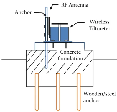
A wireless tiltmeter is a compact, waterproof tilt meter with a range of 0–80 in X and Y axis from horizontal (Fig.2). It is used to monitor changes in the inclination of an unstable slope. Tiltmeter data can provide an accurate
Digital
history of slope inclination and provide early warning of a potential landslide hazard. The system adopts the auto-monitoring and event trigger method. When the variations occur, the signal of 0.1inclination triggers the transmitter and at the same time, the digital data is transmitted to the server.
The collected data from the extensometer, tiltmeter, ARR and AWLR processed by microcontroller are sent point to point in a wireless network. The data is received by a field server; its functions are to receive, store, analyze and resend data to the central server, and decide when to announce early warnings to the local residents. The received data is then stored in a digital storing media (memory card). The central server consists of receiver equipment and a specific Personal Computer (PC) to monitor data visually. The PC, which is connected to the internet, will upload all the data to a web server; therefore, the data can be monitored from any place with internet access. Figure3shows a network diagram of a telemetric system for real-time landslide monitoring and early warning.
This real-time monitoring and early warning of landslides and debris floods has been implemented at eight geothermal areas in Sumatera, Java and Sulawesi Islands. This system was developed based on cooperation between the Faculty of Engineering Universitas Gadjah Mada and the Indonesian State-owned Oil and Natural Gas Corporation. In order to support this system installation, geological and geotechnical investigations have been conducted to examine the level of risk at the geothermal areas. Accordingly, several methods of landslide preventive measures in term of control works and restraint works were designed and applied to the high risk slopes.
Information Flow and Command System
to Support a Landslide Monitoring
and Early Warning System
Based on long experience, landslide monitoring and early warning systems should be based on the most appropriate and adaptive technology, with the involvement of the local authority and community participation. Therefore, both technical and communication skills are the main requirements to achieve success in an early warning system program. The system should include some technical aspects such as geological surveys and site selection, design of monitoring equipment which is simple (low-cost) but effective, determination of early warning levels (warning criteria), installation, operation and maintenance at the field site. Social aspects should include social mapping and evaluation, public consultation and dissemination of a program, and community empowerment, including the technical training and evacuation drills for landslide hazard preparedness (Karnawati et al.2011a).
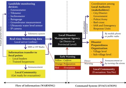
One of the most critical considerations in disaster risk reduction in Indonesia is the assurance of an effective and sustainable information flow (during warning level) and order/command flow (for evacuation). The local disaster management agency at district or provincial level acts as the center of this monitoring and early warning system. The role of universities and NGOs is to facilitate the stakeholders involved in this information and command system. Figure4 shows the information flow and command system to support landslide monitoring and early warning.
The proposed model of landslide early warning has been quite effective and strategic in improving community resilience at landslide-vulnerable villages. It is also crucial that the system should be developed through community participation and the provision of simple and low-cost technology up to real-time technology for early warning.
Discussion
The most adaptive and sustained landslide disaster risk reduction in Indonesia requires a consistent strategy and support from the government, universities, NGOs and private sectors for the implementation of community-based projects. However, there is still a gap and disconnection between the institutional and strategic approaches to disaster risk reduction which will affect the effectiveness of community-based projects in landslide-prone areas. Wireless
Tiltmeter
Concrete foundation Anchor
RF Antenna
Wooden/steel anchor
Accordingly, the outcomes from community-based activities remain isolated in time and locale, and are deprived of higher-level resources and visibilities required to sustain long-term risk reduction activities and spread capacities to other communities.
The newly developed system facilitates a network of sensors for monitoring and transmitting the hazard level to the local authorities and local community by using the sustained information flow and command system. The sensor is designed by using real-time landslide monitoring
and early warning instruments, and also may involve human sensors which comprise selected trained-people in the local community, who have been dedicated in their commitment for doing ground checking and sending reports related to any observed warning signs of potential landslides. Their understanding of the causes and landslide triggering mechanisms is crucial to establishing appropriate concepts and methods for landslide monitoring, determining warning criteria for hazard prediction and risk assessment in the region.
Repeater
Interface for real-time landslide monitoring data on PC/web Sirene and Rotary Light
as warning devices
PC-based monitoring Wireless Tiltmeter and controller
Automatic Rainfall Recorder Digital Extensometer
Ultrasonic water level sensor
IP Cam and Wi-fi
Field server for data acquisition and data loger and Receiver
Acknowledgments The authors would like to thank the International Consortium on Landslides (ICL), Indonesian Ministry of National Education, Indonesian National Agency for Disaster Management (BNPB), and PT. Pertamina Geothermal Energy for their support to this research project.
References
Anderson MG, Halcombe E, Blake JR, Ghesquire F, Holm-Nielsen N, Fisseha T (2011) Reducing landslide risk in communities; evidence for the Eastern Caribbean. Appl Geogr 31:590–599
Corominas J, Moya J, Ledesma A, Lloret A, Gili JA (2005) Prediction of ground displacements and velocities from groundwater level changes at the Vallcebre landslide (Eastern Pyrenees, Spain). Landslides 2:83–96. doi:10.1007/s10346-005-0049-1
Fathani TF, Karnawati D (2010) Early warning of landslide for disaster risk reduction in Central Java Indonesia. In: Sassa K, Yueping Y (eds) Early warning of landslides. Geological Publishing House, Beijing, pp 159–166
Fathani TF, Karnawati D (2012) Lessons learned in the development of landslide early warning system in Indonesia. In: Proceeding of IPL symposium 2012, UNESCO HQ, Paris, pp 30–34
Fathani TF, Karnawati D, Sassa K, Fukuoka H, Honda K (2008) Development of landslide monitoring and early warning system in Indonesia. In: Proceedings of the 1st world landslide forum, IPL–ISDR, Tokyo, pp 195–198
Fathani TF, Karnawati D, Legono D, Faris F (2011) Development of early warning system for rainfall-induced landslide in Indonesia. In: Proceeding of the 2nd international workshop on multimodal sediment disaster, Asian Cloud Network on Disaster Research, Tainan, Taiwan, pp 103–113
Halcombe E, Smith S, Wright E, Anderson MG (2012) Integrated approach for evaluating the effectiveness of landslide risk reduction in unplanned communities in the Caribbean. Nat Hazards 61:351–385 Karnawati D, Fathani TF, Andayani B, Legono D, Burton PW (2011a) Landslide hazard and community-based risk reduction effort in Karanganyar and the surrounding area Central Java, Indonesia. J Mt Sci 8(2):149–153
Karnawati D, Fathani TF, Wilopo W, Setianto A, Andayani B (2011b) Promoting the hybrid socio-technical approach for effective disaster risk reduction in developing countries. In: Brebbia CA, Kassab AJ, Divo EA (eds) Disaster management and human health risk II. WIT Press, Southampton, pp 175–182
Karnawati D, Frost EG, Fathani TF Subroto (2012) Smart grid for landslide monitoring and early warning system in Indonesia. In: Proceedings of the 10th anniversary of ICL, January 2012, Kyoto, pp 72–77 - Ultrasonic water level sensor - IP camera
Real-time Monitoring data Local server (online)
Information transfer to focal points
- Local leaders - Trained keypersons
Local Community (Get ready for evacuation)
Local Disaster Management Agency
(at District or Provincial Level) - Sub-village level
Local Community (Evacuation: Yes/No) Telemetry system
SMS or HT Radio
Announcement
By mobile phone or public radio
Annauncement or by turning the sirene Early Warning
Yellow : Caution Orange: Preparation
Flow of information (WARNING) Command System (EVACUATION)