Open GIS Consortium
35 Main Street, Suite 5Wayland, MA 01778 Telephone: +1-508-655-5858
Facsimile: +1-508-655-2237
Editor:
Telephone: +1-703-830-6516 Facsimile: +1-703-830-7096
The OpenGIS™ Abstract Specification
Topic 10: Feature Collections
Version 4
Copyright © 1999, Open GIS Consortium, Inc.
NOTICE
The information contained in this document is subject to change without notice.
The material in this document details an Open GIS Consortium (OGC) specification in accordance with the license and notice set forth on this page. This document does not represent a commitment to implement any portion of this specification in any companies’ products.
While the information in this publication is beleived to be accurate, the Open GIS Consortium makes no warranty of any kind with regard to this material including but not limited to the implied warranties of merchantability and fitness for a particular purpose. The Open GIS Consortium shall not be liable for errors contained herein or for incidental or consequential damages in connection with the furnishing, performance or use of this material. The information contained in this document is subject to change without notice.
The Open GIS Consortium is and shall at all times be the sole entity that may authorize developers, suppliers and sellers of computer software to use certification marks, trademarks, or other special designations to indicate compliance with these materials.
This document contains information which is protected by copyright. All Rights Reserved. Except as otherwise provided herein, no part of this work may be reproduced or used in any form or by any means (graphic, electronic, or mechanical including photocopying, recording, taping, or information storage and retrieval systems) without the permission of the copyright owner. All copies of this document must include the copyright and other information contained on this page.
The OpenGIS™ Abstract Specification Page i Volume 10: Feature Collections (99-110.doc)
Revision History
Date
Description
The OpenGIS™ Abstract Specification Page iii Volume 10: Feature Collections (99-110.doc)
Table of Contents
1. Introduction... 1
1.1. The Abstract Specification ...1
1.2. Introduction to Feature Collections...1
1.3. References for Section 1...1
2. The Essential Model for Feature Collections ... 3
2.1. Introduction to Feature Collection ...3
2.2. Feature Schema are the Key to Feature Collections ...3
2.3. Interfaces on Feature Collections ...4
2.4. References for Section 2...5
3. Abstract Model for Feature Collections ... 6
3.1. References for Section 3...6
4. Future Work... 7
1.
Introduction
1.1.
The Abstract Specification
The purpose of the Abstract Specification is to create and document a conceptual model sufficient enough to allow for the creation of Implementation Specifications. The Abstract Specification consists of two models derived from the Syntropy object analysis and design methodology [1].
The first and simpler model is called the Essential Model and its purpose is to establish the conceptual linkage of the software or system design to the real world. The Essential Model is a description of how the world works (or should work).
The second model, the meat of the Abstract Specification, is the Abstract Model that defines the eventual software system in an implementation neutral manner. The Abstract Model is a description of how software should work. The Abstract Model represents a compromise between the paradigms of the intended target implementation environments.
The Abstract Specification is organized into separate topic volumes in order to manage the complexity of the subject matter and to assist parallel development of work items by different Working Groups of the OGC Technical Committee. The topics are, in reality, dependent upon one another each one begging to be written first. Each topic must be read in the context of the entire Abstract Specification.
The topic volumes are not all written at the same level of detail. Some are mature, and are the basis for Requests For Proposal (RFP). Others are immature, and require additional specification before RFPs can be issued. The level of maturity of a topic reflects the level of understanding and discussion occurring within the Technical Committee. Refer to the OGC Technical Committee Policies and Procedures [2] and Technology Development Process [3] documents for more information on the OGC OpenGIS™ standards development process.
Refer to Topic Volume 0: Abstract Specification Overview [4] for an introduction to all of the topic volumes comprising the Abstract Specification and for editorial guidance, rules and etiquette for authors (and readers) of OGC specifications.
1.2.
Introduction to Feature Collections
The Open GIS Consortium has not yet achieved consensus on many issues surrounding Feature Collections. On the one hand, perhaps Feature Collections are not needed at all. This is because:
•
a feature can be a composite of other features,•
a “tile” may be a feature composed of the features it contains•
a feature may be “divided” by tile boundaries, yet be “reassembled” on demand by an interface on Feature or by a service.On the other hand, the real world seems full of Feature Collections that need to be addressed. These include:
•
projects, which have assignment boundaries and feature capture criteria and thresholds•
products from Government agencies, such as VPF, ADRG, SDTS, ATKIS, and similar files•
GIS database files•
the persistent or non-persistent ad hoc collection of features present at any moment in a GIS workspace.Feature Collections seem to need important interfaces in order to support the needs of Catalogs and Catalog Services. These interfaces seem to be tightly coupled with Feature Collection Metadata.
1.3.
References for Section 1
The OpenGIS™ Abstract Specification Page 2 Volume 10: Feature Collections (99-110.doc)
[2] Open GIS Consortium, 1997. OGC Technical Committee Policies and Procedures, Wayland, Massachusetts. Available via the WWW as <http://www.opengis.org/techno/development.htm>. [3] Open GIS Consortium, 1997. The OGC Technical Committee Technology Development Process,
Wayland, Massachusetts. Available via the WWW as <http://www.opengis.org/techno/development.htm>.
2.
The Essential Model for Feature Collections
Editor’s Note: This Section, while Baseline Open GIS Abstract Specification, has been assembled from portions of earlier versions of the Abstract Specification. As a result, it is somewhat disjointed, and needs unification.
We have already introduced the notion of a Feature Collection in Topic 5. We present here a deeper abstraction.
2.1.
Introduction to Feature Collection
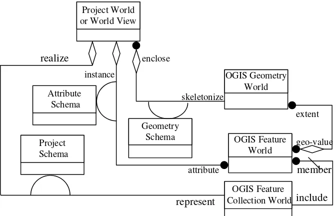
An OpenGIS Feature Collection is an abstract object consisting of Feature Instances, their Feature Schema, and Project Schema. Figure 2-1 shows OpenGIS Feature Collections in a Syntropy diagram.
or World View
geo-value Collection World
realize
Figure 2-1. Navigation Near the OpenGIS Feature Collection World
2.2.
Feature Schema are the Key to Feature Collections
Figure 2-1 can be simplified by collapsing the Geometry Schema and the Attribute Schema into the Feature Schema, as we did in Topic 5. Doing this yields Figure 2-2.
OGIS Features World Project World
or World View attribute
instance
Feature Schema
OGIS Feature Collection World
realize
represent
Project Schema
include
member
The OpenGIS™ Abstract Specification Page 4 Volume 10: Feature Collections (99-110.doc)
2.3.
Interfaces on Feature Collections
The interface between the OpenGIS Feature Collection World and the OpenGIS Feature World is called the Project Structure Interface. This interface is transparent, but it is derived from paths through the Project World. This is because the members of the OpenGIS Feature Collection World correspond directly to phenomenon in the Project World, not to a feature in the OpenGIS Feature World. Never-the-less, the methods across the Project Structure Interface, called member and include, are obvious.
The interface between the OpenGIS Feature Collection World and the Project World is called the Project Schema Interface. Its methods are also obvious, and are called realize and represent.
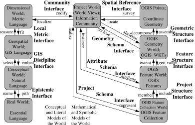
As a summary of the above, and as a reformulation of Figure 2-1, we present Figure 2-3.
name pith and Symbolic Models of
Figure 2-3. Nine Layers of Abstraction with Additional Interfaces
GIS World
or World View
Dimensional World Collection World
realize Reference System
Attribute
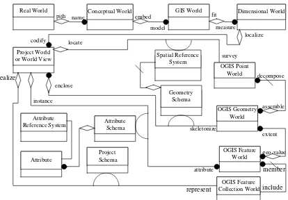
Figure 2-4. The Object Types in an OpenGIS Feature Collection
In Figure 2-4 there are fifteen object types.
2.4.
References for Section 2
The OpenGIS™ Abstract Specification Page 6 Volume 10: Feature Collections (99-110.doc)
3.
Abstract Model for Feature Collections
The Abstract Model for Feature Collections is TBD.
3.1.
References for Section 3
4.
Future Work
The OpenGIS™ Abstract Specification Page 8 Volume 10: Feature Collections (99-110.doc)