Towards Walkable Urban Neighbourhoods
Lenore Newman and Levi Waldron
Cities have always drawn people hoping for a new life, fleeing persecution, or seeking adventure, but never before have the numbers been so high. As noted by the United Nations (UN) human settlements program, half of humanity now lives in urban areas, a figure estimated to increase in future years (UN, 2008). The shift from dispersed agricultural populations to concentrated urban populations has significant implications, and in this latter stage, as Soja argues, has propelled us into an age of the spatial (Soja, 2010). This shift suggests that any serious attempt at building sustainable societies needs to focus on creating sustainable urban areas and sustainable urban centres. There is, however, a certain historical uneasiness among many environmentalists towards cities. Many regard urban areas as part of the larger and problematic process of industrialism, and yearn for a return to an idyllic vision of life in villages or small towns (Daly and Cobb, 1994: 264). Urban areas are composed, however, of neighbourhoods and
communities that face similar issues to those rural areas face, as illustrated by Dushenko (Chapter 9). To suggest that sustainability means the dismantling of cities is neither realistic, nor does it have an historical or theoretical basis (Newman and Kenworthy, 1999: 17). Cities were particularly ill-served by top down approaches typical of the second wave of sustainable development; it was a period where excessive regulation hindered ground-up innovation. As noted in the opening chapter, sustainable
development at the local or urban scale requires us to consider the intricacies and uniqueness of place. It is thus not surprising that cities are also home to many emerging third wave sustainable development initiatives; cities, as vibrant sites of human activity, are sites for sustainable development. Cities are not simply “large small towns”; they are composed of a number of communities facing local challenges as evidenced by examples from Vancouver’s east side (Dale, Chapter 6). As noted in the introduction, meaningful, diverse stakeholder inclusion and widespread community engagement is key to delivering an integrated sustainability effort. In an urban environment this inclusion can occur as niches for innovation are exploited.
Typically, cities pose interesting challenges and barriers for third-generation responses to sustainable development; infrastructure is expensive, so choices can lead to lock in, and planning regulations can be a challenge for the new and the innovative. The city, however, is where reconciliation of the three imperatives, the social, the economic, and the environmental, is crucial. Urban dwellers often live in socially and
is changing, as shown in the examples discussed in this paper. That said, the critiques provided in the introduction remain active barriers to third wave solutions in urban
environments; policy alignment is often absent, and there are not yet structures in place to encourage urban sustainable development models that embrace all citizens.
William Rees, creator of the “ecological footprint”, expressed unease at the city’s endless appetite for resources and waste sinks (Rees and Wackernagel, 1996); indeed, urban areas survive on energy and material drawn in from the surrounding countryside or, in many cases, other countries. One classic example is food sources, as discussed by Weigeldt (Chapter 7). Despite perceived negative aspects, cities are important from a cultural and societal perspective. As best argued in the works of Jacobs (1969) in “The Economy of Cities”, urban areas are the crucibles of innovation, the engines of a region’s economy. Today more than ever, urban areas are what Florida (2002) calls the “creative centres” of society, the places where the creative classes come together. Florida (ibid), building on Jacob's 1969 work, argues that such spaces are necessary to turn ideas into concrete products and actions. Ideally, cities are filled with places that are neither home spaces nor work spaces. Cities are public spaces where people can mingle, interact, and bring new ideas into being. Such spaces include parks, cafes, and, in many cases, the streets themselves. Soja calls these spaces “third places” and they have also been referred to as cultural edges, “zones of social interaction, cross-fertilization, and synergy”. This concept builds on Foucault's “heterotopias” in Of Other Spaces, in which he argues that the present epoch will perhaps be, above all, the epoch of space (1967). These edge cultures, by their very diversity, not unlike ecotones at the intersection of natural
ecosystems, have increased resilience to environmental, social, and economic challenges (Turner et al., 2003), as well as being incubation sites for new ideas and new solutions to problems. There are many reasons why most of these spaces are urban in nature cities have the population base to support research institutes, libraries, and universities. They also tend to house a diversity of people, from the young artist to the retired industrialist. More importantly, what many cities have is population density; they are places where a great number of people interact on a regular basis.
Environmentally, however, cities are sites of enormous use of energy and
resources, thus tremendous producers of waste. Though many urban areas are pioneering new waste control technologies, they remain sites of intense consumption. The sheer scale of material consumption of an average twenty-first century urban area, and its resulting forms, is an issue for most environmentalists. Under ideal conditions, however, the urban form has its benefits. Rees and Wackernagel (1996) noted that density reduces footprint due to smaller living spaces, shared walls, and shorter travel distances. With more people in a smaller area, shorter pipelines, sewers, and transmission wires are required. It has been suggested that population densities in the traditional downtown core and clusters of neighbourhoods outside of it, are key to sustainable development
If urban areas are the crucibles of innovation, and the engines of a region’s economy, as argued by Jacobs (ibid) and, if population densities in downtown cores and surrounding neighbourhoods are key to sustainable development (Kenworthy and Laube, 1996), then cities are an ideal laboratory for third-generation responses to sustainability, especially the reconciliation of place, and innovative spatial planning for diverse
transportation modes. The ground up nature of third wave approaches is reflected in the neighbourhood by neighbourhood adaptation that occurs in urban areas. If innovation is indeed largely an urban phenomenon, the reconciliation of sustainable development with space and place in large centres with access to more diverse resources is critical, if we are to achieve third-generation responses in this decade. Many barriers to its implementation exist, even with access to greater resources, for example, as discussed by Weigeldt (Chapter 7) on reintroducing nature and small food production back to the city, never mind a complex problem such as urban sprawl. Changing “the extreme separation of uses—residential, commercial, etc.—that makes people so dependent upon on their cars in the first place” (Kunster, 1993) will require novel forms of social capital building, to identify the solutions, the necessary transition strategies, and financing options for major redesign of our transportation systems.
The design of our space goes far beyond just the built environment; it is an equally strong determinant of the robustness of our social capital. Social capital is highly dependent upon the design of space in human places for connection. Without
opportunities, and one could say, random ways to connect with one another and meet in common spaces, for example in walkable neighbourhoods, we lose the capacity to engage in meaningful dialogue about the shared meaning of community (Etzionni, 2000a; b). Without a shared meaning for community, and connection with place, it is hard to achieve consensus on the characteristics of place we wish to sustain. The Kensington Market case study described below illustrates how the walkability of the neighbourhood contributed to the residents’ connection to the community, which in turn contributed to the community collectively identifying what the most important characteristics are that it wanted to sustain and maintain. The reconciliation of place and space involves being in a relationship with place and with one another, as argued by Dale and Robinson in the concluding chapter.
The Automobile Landscape
Interestingly, the smaller-scale structure has also fundamentally changed, with architecture and signs designed to attract the attention of the fast-paced motorist rather than the slow-paced pedestrian (Freund and Martin, 1993). The automobile landscape can be sterile and alienating to citizens. As observed by Matsuokaand Kaplan (2008), urban residents worldwide express a desire for contact with nature, with each other, attractive environments, and recreation areas. Cities designed around cars, however, do not provide such spaces. Automobile landscapes exist fundamentally for anti-urban reasons; they arose to facilitate the relocation of millions of people out of urban cores into suburban landscapes. One of the greatest questions facing sustainable development is how to reverse this shift.
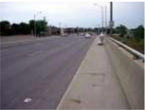
Figure 1: A lone pedestrian wheeling his groceries through a dreary, car-dominated landscape on Keele Street over Highway 401 in Toronto, Ontario
The car is one of the major impacts on the urban environment (Kenworthy and Laube, 1996). Its social and environmental consequences are far-reaching, from the local to the global scale. Vehicle construction is material intensive and the construction of vehicle infrastructure more so. Large land areas are needed to facilitate car travel and large expanses of impervious pavement reduce aquifer recharge, increase runoff, and worsen the “urban heat island effect”, as pavement absorbs heat during the day and radiates it at night (Crutzen, 2004). Runoff from paved areas is a toxic brew of oil, salt, and other chemicals having adverse effects on water quality. Pavement also prevents aquifer recharge, reducing water quantity (Schutes et al, 1997).
On a global scale, the transportation sector generates 26% of greenhouse gases, and passenger transportation accounts for 60% of emissions from transportation sources, not including emissions related to petroleum refining, automotive manufacturing, or road-building. In Canada’s 13 largest cities, over 75% of the greenhouse gas emissions
pollution in Ontario alone is 5,800 premature deaths, 17,000 hospital admissions, 60,000 emergency room visits, and 29 million minor illness days. The associated cost is
estimated at approximately $374 million in lost productivity, and $507 million to the health care system, with strongly increasing trends in all health and economic impact figures (Ontario Medical Association, 2005).
Figure 2: Massive Road infrastructure and usage such as Highway 401 in Ontario has a global impact
Cars interrupt the interaction between people and their spaces, or what Soja (1980) calls the social-spatial dialectic. The automobile infrastructure also freezes the natural evolution of cities. In a human-scaled settlement, people and their spaces co-evolve in a process of what Jacobs termed organized complexity (Jacobs, 1961). Jacobs noted that "new ideas need old buildings", and demonstrated how innovators use portions of the existing cityscape to their own ends, rewriting space as they do (Ibid). A well-planned city is one with a lot of flexibility of use, or what is often referred to as multi-functionality (Ling et al., 2007; Brandt et al., 2000). Automobile infrastructure is notoriously unifunctional; once a space has been allocated to cars it is seldom useful for anything else. In simple terms, people don't like or feel comfortable on the hot bare expanses created by car culture, as shown in Whyte's seminal Street Life project (1980). What most attracts people is other people, and they gravitate to spaces filled with sun, trees, water, food, and seating. Whyte found spaces need to be comfortable, and
walkable, and the emerging realization that these spaces also can have a large impact on human health.
Walkability and Health
communities of all sizes, but the results have been similar everywhere. The combination of low density and separated use was supposed to provide a means for everyone to enjoy country living; however, the byproduct of this way of life has been that one must drive to perform even the simplest of daily tasks.
Car culture and pedestrian culture do not coexist easily. If buildings have sufficient parking for each tenant, the resulting parking lot increases the buildings’
footprint to the point where walking from place to place becomes difficult. In most North American urban areas, buildings are islands in seas of asphalt, too far from their
neighbours to make foot traffic practical. The shift from a walking culture to a driving culture has also had a serious impact on individual health. Good health requires “active community environments” where people can take part in daily physical activity (Doyle et al., 2006). Before the widespread adoption of automobile use, most people simply had to walk a good distance each day. Obesity has now become widespread, due in part to a lack of physical activity such as utilitarian walking (Frank and Engelke, 2005) and research has shown that people in walkable areas tend to weigh less (Doyle et al., 2006).
Urban planning directly affects health (Frumkin et al., 2004). Planning for walkable neighbourhoods could greatly improve the mental and physical health of our sedentary population. Care needs to be exercised, however, so that the problems that originally drove people out of walkable urban areas are corrected. Laws control the placement of the worst industrial offenders and regulate housing standards, with implications for some forms of local food production (see Weigeldt, Chapter 7), but vehicles remain one major source of pollution in today’s cities. Some researchers have cautioned that higher density walkable neighbourhoods could reduce air pollution over all, but increase it locally (Frank and Engelke, 2005). While tightening emissions standards, limiting vehicle access to local neighbourhoods or removing those vehicles entirely may mitigate this, the ideal walkable neighbourhood might be a car-free one. Given that a major study by Basset et al., (2008) showed that Americans walk only 0.4 km a day on average, it is understandable that health problems and obesity are at epidemic proportions. The same study showed that Europeans walked three times as much per day, largely due to differences in the urban form, suggesting that urban planners could contribute to human health and sustainability by creating more walkable spaces.
Walkability, Social Capital and Agency
and interactions between people, as well as through networks that a group can use
collectively to achieve its objectives. Effective mobilization of social capital involves the creation of networks with a sense of common purpose. Networks are a powerful means of distributing knowledge through social interaction and can lead to the reconciliation of previously competing information, interests and agendas (Dale and Onyx, 2005).
For decades, opportunities for the growth and development of social capital, however, have been declining in many communities (Putnam, 1999). Some of the decline was the result of poor urban planning. Poor planning without due regard for
socio-economic considerations has been shown to destroy or thwart any development of social capital (Frumkin et al., 2004). As Reuf et al. (2003) note, “geography matters”. If people live within a nuclear family in detached homes and drive in private vehicles to perform even the most basic of tasks, there is no life on the streets, no chance meeting of neighbours, and no interaction at local stores run by people from within the
neighbourhood. In short, many of the places where social capital is generated will simply not exist. This intuitive assumption is supported by research whereby social capital has been found to be higher in walkable neighbourhoods (Leyden, 2003), and the decline of social capital has been directly related to certain forms of suburbanization (Leyden, 2003).
Third-generation responses to sustainable development embrace the social, as well as the environmental and the economic. To that end, social capital is critical in creating agency (Newman and Dale, 2005), which is “the capacity of an individual or group to plan and initiate action” (Onyx and Bullen, 2000). If community groups are to successfully fight for better neighbourhoods designed to improve their physical health, agency is needed. Physical and social environments, however, play key roles in agency maintenance/creation (Horvath, 1998). It is hard, therefore, to build the agency needed in badly designed neighbourhoods to challenge that design. This “catch 22” dilemma suggests that neighbourhood action alone is not enough, and that planners must play an active and central role in encouraging walkable urban neighbourhoods.
Granville Mall: Planning and the Pros and Cons of the “Car-Free” Street
One of the easiest ways to create a car-free area in an urban centre is to close a single street to traffic or certain types of traffic, creating a pedestrian mall. This method has proven popular in Europe, and is quite successful. The City of Utrecht in The
Netherlands, for example, has several car-free streets in the old city centre that team with pedestrians during the workweek, and hosts a successful farmer’s market on weekends. The North American experience, however, is somewhat different. Of 200 car-free malls established in the US, between 1970 and 1998, 100 were subsequently reopened to traffic (Crawford, 2002). This significant failure rate suggests changes are needed to the North American planning approaches and processes for creating car-free areas.
Other studies also show that the number of people who will walk is very sensitive to distance. Whether someone will walk to a corner store depends on whether it is 200 or 600 meters away (Krizek and Johnson, 2006). One factor that is often cited as a
disincentive to walking is the extreme winter weather found in much of North America. There are many examples, however, of successful walkable neighbourhoods in
Scandinavian cities (Kennedy, 2008). The difference is in the thought given to designing for the weather (see McDonald, Chapter 10).
Another weakness in pedestrian malls in North America is that they are not entirely car free. In the Granville Mall in Vancouver, British Columbia, this downtown core area was designated a pedestrian mall in 1974 in an effort to revitalize the city’s once thriving theatre strip (City of Vancouver, pers. com). As part of this revitalization, trees were planted, the street itself was rebuilt as a series of curves to slow traffic, and sidewalk widths were increased to seven metres. A six-block stretch of the street was also closed to automobile traffic. The success of the project, however, has been mixed since there are few attractions to draw pedestrians along much of this stretch. Walkers confront the blank wall of an enclosed mall and a major department store, and for many years, one block bordered on a vacant lot. As a result, the project did not have the diversity of businesses, residences, or other draws in close proximity needed to revitalize the area. Although six blocks were closed to car traffic, the major barrier to pedestrian traffic was that it was not closed to trolleybuses. As many as 1,900 trolleybuses pass daily through the core (City of Vancouver, 2006). Constant bus traffic and few attractions led to a general decline of the area and, in 1988, the city re-opened one block to traffic. The attraction for pedestrians in the remaining blocks has improved as more businesses opened in the area, and construction of the city’s new transit line might decrease bus traffic in the area. The Granville Mall’s future success as a pedestrian area, however, is still uncertain as the street was closed for the excavation of the Canada Line rapid transit, but bus service resumed in September 2010. In many ways the failure of the Mall as a public space reflects the weakness of the first and second wave approach; though traffic flow and urban form were controlled by the municipality, little thought was given to how the project fit into the broader context of the neighbourhood and the surrounding land uses.
Planning for Walking
What makes a successful pedestrian area, is certainly that small blocks encourage walking, (Crawford, 2002) as they create multiple paths between destinations. People tend to walk more where there are more intersections, and blocks are shorter (Doyle et al., 2006). Dense networks create three conditions that fuel vibrant urban form: density, proximity, and connectivity (Frank and Engelke, 2005). Atypical street design can also aid pedestrian spaces. T-junction intersections, for example, although not conductive to automobile traffic, provide a natural focal point for an area. These also serve to enclose a neighbourhood, and studies have shown that pedestrians prefer communities with clear boundaries (Crawford, 2002).
Neighbourhoods such as those described above, however, are not easy to find in North American urban areas. Many historic districts meet these requirements, but 80% of buildings in the U.S. were built in the last 50 years (Kunstler, 1993). These new
space absorbed by urban transport systems has a critical effect on urban form (Crawford, 2002). Housing also covers a larger footprint; living area per family member, for
example, has increased by a factor of three since the 1950s in the US (Wilson and Boehland, 2005). Also, 63% of Americans now live in single-family dwellings (Wilson and Boehland, 2005), a shift that requires vast amounts of land to accommodate.
Interestingly enough, much of the original urban infrastructure (including roads) built in the last fifty years in North America is also beginning to fail, either prematurely or as it reaches its anticipated service life expectancy. This presents challenges as well as opportunities for new forms of urban renewal and sustainable design in cities, as discussed further below.
As the unsustainable nature of current planning and infrastructure choices becomes clear, there is increasing interest in patterns that better accommodate higher densities. One such popular model is that of “smart growth,” which aims to revitalize community in city centers and established communities through mixed use, transit use, and pedestrian spaces (Barnett, 2007). Smart growth provides a mix of commercial, business and retail uses in order to lower commutes and encourage pedestrian traffic. Smart growth also encourages compact building design. Conventional development is land extensive, often to the point of providing insufficient density for local transit and walkability. Increasing density also decreases the ecological footprint through reduced sprawl, and lowers service costs, as discussed earlier. Planning is a key driver in reducing the need for a car (Newman and Kenworthy, 1999)
Kensington Market: Pedestrianizing Existing Walkable Areas
One recent site of a car-free initiative in Canada is the Kensington Market community in central downtown Toronto, a 35-hectare area bound by major streets carrying streetcar lines. Though well served by public transit, the area is clogged with vehicle traffic, parked cars, and delivery trucks. Two municipal garages providing ample parking encouraged people to drive into the area.
That Kensington Market exists at all is rather remarkable, given that it has faced various renewals and clean up initiatives, and was almost destroyed completely during a period of freeway development in the city. In the 1960s, planners cleared similar areas across Toronto in order to build blocks of planned housing surrounded by “dead space”, large pedestrian-unfriendly landscapes, in a process viewed by some as a terrible failure. The Alexandra Park area to the south of Kensington Market was cleared for such a project, and is now rundown and quite intimidating, especially at night (pers. obs.). Grassroots opposition stopped a similar re-structuring plan for Kensington Market at the time. This demonstrates the strong social capital that exists in such neighbourhood communities.
all of their utilitarian household needs. What is not available in the market proper, such as hardware and alcohol, can be purchased on the main streets near the market entrances.
In many ways, Kensington Market is an ideal example of a walkable urban neighbourhood. It is also, however, an example of the damage that cars can do in a confined space. In the last few years, grassroots interest in making the market car-free at least some of the time has lead to the tradition of Pedestrian Sundays in Kensington Market. This project began in the summer of 2002 when a group of employees at an area restaurant expressed concerns about the congestion and pollution in the neighbourhood. They also felt unsafe on the streets, as small fender benders were common. The
employees decided to take action and gathered friends, neighbours, and activists together in an event they called “Streets are for People!: A celebration of bikes, pedestrians, and the idea of a car free Kensington Market”. Organisers paid the parking meters along a section of street and the resulting “rented” space was used to have a picnic and play music. This impromptu street party ultimately blocked vehicle traffic, reclaiming the street.
Streets are for People! held a third, larger and more formal event consisting of a market-wide parking meter party. This revealed a strong polarization of opinions around the idea of a car-free Kensington. Many merchants feared the potential impact upon their business, concerns that have often been raised during the construction of European car-free areas. In the summer of 2003, Streets are for People! met with the organisers of Red Pepper Spectacle Arts. This local community arts organisation had been planning a Harvest Festival for that fall that would involve all of the merchants of the
neighbourhood in a street festival of food, culture, music, and art. The two groups collaborated on the building of the Harvest Festival, working closely with the merchants of the market to gain their cooperation and support.
With the success of the Harvest Festival, neighbourhood stakeholders gained a new perspective on how the streets could be used. Further plans were developed to have weekly street closures during the next summer on Sundays, the day with the fewest deliveries, and which seemed the least disruptive to business. A larger working group, “P.S. Kensington” or “Pedestrian Sundays”, was formed to pursue the project. The City of Toronto agreed to collaborate on the Pedestrian Sundays, and supported the inaugural year with staff and some funding. Unfortunately, as P.S. Kensington became a city-sponsored event held on city streets, the event became subject to a series of municipal regulations. This included requirements for insurance, paid-duty police officers, barricades, and regulated signage for a special event, which increased the financial
burden of running Pedestrian Sundays. Despite these barriers, the events were considered successful. At the grand street opening of the first Pedestrian Sunday, urban planner Jane Jacobs spoke of how this was just the way things ought to happenthe community gets a good idea and the city helps to support it.
about the survey while a small number of critics effectively communicated ensuring that those opposed to the events responded. Community organisers explored having smaller block parties, just to keep the spirit of Pedestrian Sundays alive, even if they weren’t allowed to do full market street closures. Following complaints regarding the cancellation of Pedestrian Sundays, community organisers conducted their own survey to examine the level of support for continuing the project. Results indicated even greater support for the project than the previous year, following a few weeks of individual discussions with each merchant and many residents. The decision to continue with a second summer of
Pedestrian Sundays, however, came too late to apply for grantsor funding. The organisers forged ahead, fundraising approximately $2,500 per event from local merchants and environmentally minded Toronto residents to run Pedestrian Sundays, while at the same time planning and running the events. The shift to local funding suggests that, despite early misgivings, area merchants grew to enjoy the events and the business they draw to the area.
P.S. Kensington continues to lead a bipolar existence; the events are hugely popular, but are always at risk of being cancelled for lack of funds. Kensington Market is a natural location for a pedestrian-only demonstration project, demonstrating many key characteristics of walkable communities within cities. These include narrow streets, short blocks, and T-junctions that help to enclose the streetscape, as well as being very well serviced by rapid (public) transit. Even in such an ideal setting, however, the city’s planning rules are a central consideration in that the longer-term survival or expansion of street closures in the market may rest on changes to government regulations that make the events cheaper and easier to continue. Dale discusses this “path dependence” by
institutions, such as governance bodies, and the requirement of unique stimuli to induce endogenous changes, in the Introduction.
Equity Issues
Walkable neighbourhoods can improve our quality of life. As discussed earlier, they increase the health of their residents, encourage and are supported by social capital, and eliminate unpleasant commuting which disconnects us from our environment. Given these positives, and that such neighbourhoods are scarce, it might be imagined that such areas are in demand and highly desirable. Although this is certainly true, it raises the possibility that, as long as walkable neighbourhoods remain the exception rather than the norm, they will demand high rents and property values.
Little study has been conducted concerning the “gentrification” of walkable neighbourhoods, whereby deteriorated neighborhoods are rehabilitated by new, wealthier residents instead of the long-time residents, resulting in increased housing prices and displacement of the latter. Literature on the subject supports the hypothesis that walkable neighbourhoods will inevitably gentrify. In Europe, pedestrian zones have been shown to push out lower class retail in favour of higher class chain stores (Leyden, 2003).
walkability, they might find themselves priced out of their own homes as victims of their own success. This effect should decrease as more walkable neighbourhoods are built in a supply and demand relationship. It would also be a function of the original nature of the neighbourhood [i.e., commercial, industrial, residential, even small-scale agriculture (see Weigeldt, Chapter 7) or combination] and the values it supports.
Conclusion
The great walkable cities of the world were actively planned either before cars were developed, or with the express purpose of facilitating food traffic. They developed following patterns dictated by geography and the limitations of the pedestrian before the widespread use of private automobiles. The self-organised city has proven to be a leader in sustainable, livable spaces. In the urban context, third-generation responses to
sustainable development will require a new sort of urban planning that expressly encourages pedestrian spaces. Planning for mixed use, small streets, and human-scaled places must replace the creation of urban forms designed for the automobile. A
reconciliation of place and space is clearly needed, indicative of third-generation
responses. Projects such as that in Kensington Market bring forward the social imperative of sustainable development, and incorporate it into the urban fabric. Unfortunately, this last half-century has led to a Catch 22 situation. In consciously shifting our concept of urban landscape around the car, creating a sustainable space that will immediately be walkable in reconnecting with place will be difficult even if we limit or create incentives for reducing automobile traffic. Planning rules need to change in order to create
neighbourhoods of the right scale for walking. Conscious demand for such
neighbourhoods varies. In Europe, 85% of the population supports drastic limitations on cars in cities (Leyden, 2003), but such widespread support is not found in North America. This could be a result of what Jared Diamond calls “landscape amnesia” (Diamond 2005 425); the majority of car-oriented North Americans have never experienced the livability and “freedom” of a walkable neighbourhood.
The benefits of walkable urban landscapes are clear. Residents of such areas have smaller ecological footprints, are in better health, and enjoy higher levels of social
References
Appleyard, D. (1981) Livable Streets. Berkeley: University of California Press.
Barnett, J. (2007) Smart Growth in a Changing World. Chicago: American Planning Association.
Basset, D, Pucher, J, Buehler, R, Thompson, D. and S. Crouter. (2008) Walking, Cycling, and Obesity Rates in Europe, North America, and Australia. Journal of Physical Activity and Health, 5: 795-814.
Bourdieu, P. (1986) The Forms Of Capital. In John G. Richardson (ed.) Handbook of Theory and Research for the Sociology of Education. New York: Greenwood Press. pp. 241-258.
Brandt, J. B. Tress, and G. Tress. (2000). Introduction to the conference theme, in: Multifunctional Landscapes: Interdisciplinary Approaches to Landscape Research and Management: Material for the Conference on ‘Multifunctional Landscapes’, Centre for Landscape Research Rokilde, 18-21, October, p. 15.
Brereton, F, Clinch, J, and S. Ferreira. (2008). Happiness, Geography, And The Environment. Ecological Economics, 65(2): 386-396.
Burden, D., 1995, Twelve Steps Toward Walkable Communities. Florida Department of Transportation, Tallahassee.
Calthorpe, P., Fulton, W.B. and R. Fishman. (2001). The Regional 474 City. Washington: Island Press.
City of Vancouver, (2006). http://www.vancouver.ca/dtp/granmall.htm.
Crawford, J. (2002) Car Free Cities. Utrecht: International Book.
Crutzen, P. (2004). New Directions: The Growing Urban Heat And Pollution Island Effect-Impact On Chemistry And Climate, Atmospheric Environment, 38: 3539-3540.
Dale, A. and J. Onyx. (2005). A Dynamic Balance. Social Capital and Sustainable Community Development. Vancouver: UBC Press.
Daly, H.E and J. B. Cobb. (1994). For the Common Good (2nd ed.). Boston: Beacon Press.
Diamond, J. (2005). Collapse: How Societies Choose to Fail or to Succeed. New York: Viking Press.
Communities to Individual Health. Journal of the American Planning Association, 72(1): 19-31.
Elliott, D.L. (2008). A Better Way to Zone: Ten Principles to Create More Livable Cities. Washington: Island Press.
Evans, R., Dawson, J. (1993). Liveable Towns and Cities. Civic Trust and Grand Metropolitan, London.
Florida, R. (2002). Rise of the Creative Class. New York: Basic Books.
Foucault, M. (1967). Of Other Spaces, reproduced at
http://foucault.info/documents/heteroTopia/foucault.heteroTopia.en.html
Frank, L and P. Engelke. (2005) Multiple Impacts of the Built Environment on Public Health: Walkable Places and Exposure to Air Pollution. International Regional Science Review, 28(2): 193-216.
Freund, P. and Martin, G. (1993) The Ecology of the Automobile. Montreal: Black Rose Books.
Frumkin, H., Frank, L. and R. Jackson. (2004) Urban Sprawl and Public Health: Designing, Planning and Building for Healthy Communities. Washington: Island Press.
Kunstler, J. (1993). The Geography of Nowhere. The Rise and Decline of America’s Man-Made Landscape. New York: Simon and Schuster.
Jacobs, J. (1969) The Economy of Cities. New York: Random House.
Jacobs J. (1961) The Death and Life of Great American Cities: The Failure of Town Planning. New York: Random House.
Kennedy, J. (2008) Winter Walkability Presentation at the Federation of Canadian Municipalities Conference, February 15th, Ottawa, Canada.
Kenworthy, J. and F. Laube. (1996) Automobile Dependence in Cities. Environmental Impact Assessment Review, 16: 279-308.
Krizek, K. and P. Johnson. (2006) Proximity to Trails and Retail: Effects on Urban Cycling and Walking. Journal of the American Planning Association, 72(1): 33-42.
Kunstler, J. (1993) The Geography of Nowhere: The Rise and Decline of America’s Man -made Landscape. New York: Simon and Schuster.
Leyden, K. (2003) Social Capital and the Built Environment: The Importance of Walkable Neighbourhoods. Research and Practice, 93(9): 1546-155.
Ling, C., J. Handley and J. Rodwell. (2007). Restructuring the post-industrial landscape: A multifunctional approach. Landscape Research, 32 (3): 285-309.
Matsuoka, R.H. and R. Kaplan. (2008). Peoples Needs In The Urban Landscape: Landscape And Urban Planning. Landscape Urban Plan, 84: 7–19.
Mahon, M., F. Fahy, and M. Ó Cinnéide, 2009. The significance of quality of life and sustainability at the urban-rural fringe in the making of place-based community. GeoJournal. November 2009. Online First.14 pp.
National Round Table on the Environment and the Economy. (1998) Greenhouse Gas Emissions from Urban Transportation. Retrieved 13 Sep 2006 from http://www.nrtee-trnee.ca/Publications/PDF/BK_Urban-Transportation_E.pdf.
Newman, L. and A. Dale. (2005). The Role of Agency in Sustainable Local Community Development. Local Environment, 10(5): 477-486.
Newman, P. and J. Kenworthy. (1999). Sustainability and Cities: Overcoming Automobile Dependence. Washington: Island Press.
Ontario Medical Association. (2005). The Illness Costs of Air Pollution. Retrieved 13 Sep 2006, from http://www.oma.org/Health/smog/report/ICAP2005_Report.pdf.
Onyx, J. and Bullen, P. (2000). Measuring Social Capital in Five Communities. The Journal of Applied Behavioral Science, 36(1): 23-42.
Putnam, R. (2000) Bowling Alone: The Collapse and Revival of American Community. New York: Simon and Schuster.
Rees, W, and Wackernagel, M. (1996). Urban Ecological Footprints: Why Cities Cannot Be Sustainable and Why They Are a Key to Sustainability. Environmental Impact Assessment Review. 16: 223-248.
Reuf, M, Aldrich, H. and N. Carter. (2003). The Structure of Founding Teams:
Homophily, Strong Ties, and Isolation Among US Entrepreneurs. American Sociological Review, 68(2): 195-222.
Shutes, R.B.E., Revitt, D.M., Mungur, A.S. and L.N.L. Scholes. (1997). The Design Of Wetland Systems For The Treatment Of Urban Run Off. Water Science Technology, 35(5): 19-25.
Southworth, M. (2005). Designing The Walkable City, J. Urban Plan. D-ASCE. 131(4): 246-257.
Turner, N, Davidson-Hunt, I, and M. O’Flaherty. (2003) Living on the Edge: Ecological and Cultural Edges as Sources of Diversity for Social-Ecological Resilience. Human Ecology, 31(3), 439-463.
United Nations, (2008) United Nations Centre for Human Settlement, www.unhabitat.org/.
Wilson, A. and J. Boehland. (2005). Small is Beautiful: US House Size, Resource Use, and the Environment. Journal of Industrial Ecology, 9(1/2): 277-287.