Synopsis of Ecological and Socio-Economic Aspects
of Tropical Coastal Ecosystem
with Special Reference to Segara Anakan
Editors:
Edy Yuwono
Tim Jennerjahn
Moh. Husein Sastranegara
Purnama Sukardi
Research Institute
University of Jenderal Soedirman
Purwokerto
Synopsis of Ecological and Socio-Economic Aspects
Synopsis of Ecological and Socio-Economic Aspects of
Tropical Coastal Ecosystem with Special Reference to Segara Anakan
Editors
: Edy Yuwono
Tim Jennerjahn
Moh. Husein Sastranegara
Purnama Sukardi
Published by
: Research Institute
The University of Jenderal Soedirman
Address
: Jl. dr. Suparno
Purwokerto
53122
Telp./ Fax. +62 281 642083
Preface
The Indonesia-German initiative on Earth System Research “Science for the Protection of Indonesian Coastal Marine Ecosystems” (SPICE) Phase I was conducted between 2003 to 2007. The program included field trips to Segara Anakan, Cilacap, Central Java, which lies between 108°46’ - 109°03’ E and 7°35’ - 7°48’ S, and laboratory works in the University of Jenderal Soedirman (UNSOED) Purwokerto as well as workshops attended by scientists, students, non-government organizations, industry, local authorities and other stakeholders.
The Segara Anakan consists of a lagoon isolated from the Indian Ocean by Nusakambangan island, mangrove forest areas, settlement areas, and rice field areas. In the north of Segara Anakan, there are agricultural areas, whereas in the south primarily rain forest is covering most parts of Nusakambangan island. In the east the lagoon is bordered by the city of Cilacap. The environmental changes due to natural causes as well as the impact of human activities are evident in this lagoon-mangrove ecosystem. The lagoon became narrower and shallower due to sedimentation in the west part, and the water condition has been deteriorated by pollution in the east part which is close to industrial and settlement areas. In addition, illegal logging resulted in the decrease of mangrove areas. The complexity of natural and human made phenomena had also created not only ecological problems but also social conflicts and economic loss.
These complex phenomena of Segara Anakan were discussed in a “Workshop on Ecological and Socio-Economic Aspects of Segara Anakan Cilacap”, in March 26-27, 2007, organized by Research Institute, University of Jenderal Soedirman, Purwokerto, Indonesia in collaboration with Zentrum für Marine Tropenökologie (ZMT) Bremen,
Germany within the framework of the SPICE project. Results of the field trips and laboratory works conducted during the implementation of SPICE Phase I were presented in the workshop and are documented in this book. The book describes ecological aspects including the importance of mangrove vegetation of Segara Anakan as a habitat of various living organisms, the mangrove conversion and its degradation due to illegal logging, the present environmental conditions in the lagoon and the abundance and community composition of organisms living in the ecosystem such as benthic organisms and keystone species of the intertidal crab community. Socio-economic aspects such as conflicts of communities along the Donan River and the empowerment of rural coastal community in the northern part of Segara Anakan area are elucidated.
We are grateful to the German Federal Ministry of Education and Research (BMBF) Germany for supporting SPICE Project Phase I implemented during 2003 – 2007 in which the workshop has been important part of the activities. The project was also supported by the Ministry of Marine Affairs and Fisheries (DKP), and the Ministry for Research and Technology (MENRISTEK) of the Republic of Indonesia. Contributions by the authors and support by ZMT and UNSOED have made the dissemination of the manuscripts presented in the “Workshop on Ecological and Socio-Economic Aspects of Segara Anakan” through this book possible.
September, 2007
CONTENT
Page
ECOLOGICAL ASPECTS
Mangrove Vegetation of Segara Anakan Cilacap, Java, Indonesia: Structure
Composition, Litter Fall Production and Composition, by Rudhi Pribadi 1
Spatial and Temporal Dynamics of Mangrove Conversion at the Segara
Anakan Cilacap, Java, Indonesia, by Erwin Riyanto Ardli 11
Illegal Logging of Mangroves at the Segara Anakan Cilacap, Java, Indonesia: A Conservation Constraint, by Moh. Husein Sastranegara , Edy Yuwono &
Purnama Sukardi , 21
Environmental Conditions in the Segara Anakan Lagoon, Java, Indonesia, by
Tim Jennerjahn, Peter Holtermann, Insa Pohlenga & Bushra Nasir 28
The Benthic Community in the Segara Anakan Lagoon, Java, Indonesia, by
Inga Nordhaus 33
The Intertidal Crab Community of the Segara Anakan Lagoon, Java,
Indonesia during the Dry Season 2005, by Simon Joscha Geist 39
Parasites as Bioindicators for a Risk Classification System around and within
Indonesian Grouper Mariculture, by Sonja Rückert & Harry W. Palm 44
SOCIO-ECONOMIC ASPECTS
Governance Problems in Managing Donan River Uses, Cilacap, Java,
Indonesia, by Slamet Rosyadi, Imam Widhiono & Petrus Hary Tjahja Sudibya 50
The Empowerment of Self-help Group (Milk Fish Aqua-culturist) in Tritih Kulon, Cilacap, Java, Indonesia, by Purnama Sukardi, Edy Yuwono,
Sugiharto, Moh. Husein Sastranegara, Lucie Setiana, Hartoyo, Isdy Sulistyo,
MANGROVE VEGETATION OF SEGARA ANAKAN CILACAP,
JAVA, INDONESIA: STRUCTURE COMPOSITION, LITTER-FALL
PRODUCTION AND DECOMPOSITION
by
Rudhi Pribadi
Department of Marine Science, University of Diponegoro, Semarang, Indonesia
Introduction
Mangroves ecosystems are highly productive with a high litter production (Snedaker and Brown, 1981; Proctor, 1984) and are believed to enhance near-shore primary and secondary production (Macnae, 1974; Mann, 1982). Odum (1969) described mangroves as interface or open systems because of their flow-through pathways for transporting matter. These pathways are driven by physical (tides, terrestrial runoff, and rainfall) and biological (litter production, decomposition, mineral uptake and faunal activities) factors that control the rate of matter import, export and storage (Pool et al., 1975). The result of these flows and
transformations is the import of inorganic matter from terrestrial ecosystems and the export of both particulate and dissolved organic matter to adjacent marine ecosystems.
Mangroves provide important feeding and nursery areas for many fishes (Knox and Miyabara, 1984). Their most important function for fisheries however is their role as nursery areas. Attempts have been made to determine the relationship between mangrove areas and offshore shrimp production. Martosubroto and Naamin (1977) suggested that there is a significant linear relationship between the two, and that any reduction in mangrove area will cause a reduction in shrimp production. A regression analysis of annual prawn production with mangrove area and latitude, using a world-wide data set (Turner, 1977), showed that in Indonesia one could expect a production of about 100 kg of prawns/ ha/ year of mangrove. Nair (1977) has attempted to quantify the economic trade offs between mangrove forestry and offshore prawn fisheries in Sabah. In Australia, Staples et al. (1985) found a high positive
correlation between the length of the mangrove-lined section of rivers and the mean annual commercial catch (1973 to 1982) of the banana prawn (Penaeus merguiensis de Man) in
different areas of the Gulf of Carpentaria. Adults of the commercially important penaeid prawns usually spawn at sea and after a short larval life (2 - 3 weeks), the post larval stage settles in the near inshore areas and estuaries (Dall et al., 1990).
sedimentation and infilling from the inlet rivers. Two options has been recommended to solve this serious sedimentation threat i.e. inlet diversion, and lagoon dredging which now is on going.
The main purpose of this study were to describe mangrove vegetation and some of its ecological processes within Segara Anakan lagoon, Cilacap Specifically, the project aims were:
1. to describe the mangrove floristically, including the structure and composition of the vegetation and its regeneration;
2. to determine the small litter-fall production, quantify its nutrients, and 3. to estimate its rate of decomposition.
Material and Methods
1. Forest structure and composition
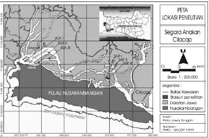
There are three main locations on the study: Klaces area (KLA) representing the most impacted area and Sapuregel area (SAP) that is less impacted. Some study was also set up in Motehan (MOT) area as the transition between the two locations. Three stations of 500 m length transect line was designated for each station. All study designed to be comprehensively conducted on the same sites therefore its information obtained would be integrated and hopefully supporting one to another.
Figure 1. Study sites in Segara Anakan Cilacap.
trees with diameter ≥ 4 cm were measured (diameter and height) and identified to species. The number of saplings (diameter < 4 cm and height ≥ 1 m) in each 20 x 20 m plot were recorded in one 5 x 5 m quadrat, and the number of seedlings (diameter < 1 cm and height less than 1 m) in one 1 x 1 m quadrat. The quadrats were placed in a certain corner of each 10 x 10 m plot. They are treated here as statistically independent samples. The physiognomy of each representative site was determined by a series of profile diagrams. Each tree and sapling species present in these representative plots were plotted for their position and measured for diameter, height (bole and total height) and canopy width.
2. Litter-fall and litter-layer
On each transect of 500 m were installed 5 litter traps for upper plants and 5 litter traps for lower plants (Acanthus and Derris) with a distance in between approximately 100 m. In total 45 sets of trap of each category were installed. The upper-plant litter-fall were collected using traps which were made by attaching a conical-shape nylon mesh (2 mm) to a 1 m X 1 m wooden frame and hanged about 1.5 m above the mean high water level at spring tide. The lower plant litter-fall were collected using 1 m x 1 m x 1m open top and bottom cages of nylon mesh (2 mm) which encircled the target plants. The litter-fall collected from each trap on the 15th and on the last day of each month for a year period then bulk by month before sorting into leaves, branches, fruits and flowers, and a miscellaneous fraction. The fractions were subsequently dried to a constant weight at 70 o C for at least 72 h prior to weighing. A substantial number of samples were randomly picked from the batch for further chemical analysis (N, P, K). The small litter-layer was collected from 1 m x 1 m wooden frames that set up on the forest floor. The frames positioned in the same 20 m x 20 m plots as for the litter-fall collection, but they were only collected on the last day of each month. Only leaf, stipule, reproductive part, and small wood litter-layer were collected. The litter-layer then cleaned, dried, sorted and weighed using the same methods as for litter-fall. The litter-fall decomposition rate (or, in the case of mangroves, litter-fall loss-rate, since there may be removal by the tide) was calculated as the ratio of annual litter-fall mass (L) to litter-layer or standing crop (Xss), k = L / Xss. Turnover rate, the rate of the amount of a substance released by or entering into a compartment in a given time was defined as the inverse form of decomposition rate (1/k). Half-lives (t0.5) (assuming an exponential model applies), were calculated as 0.693/k (Olson 1963).
3. Leaf-litter decomposition
Decomposition was studied using freshly-fallen leaf-litter (collected from the forest floor at low tide) of Acanthus ilicifolius, Aegiceras corniculatum, Avicennia alba, Bruguiera gymnorrhiza, Ceriops tagal, Derris trifoliata, Excoecaria agalocha, Finlaysonia sp., Rhizophora apiculata, Scyphyphora hydropillacea, Sonneratia alba and Xylocarpus granatum. Ten grams of this leaf-litter were enclosed separately in 30 cm X 30 cm 2-mm
Results and Discussion
1. Forest structure and composition
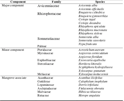
In total, there are 26 species of 15 mangrove families recorded in the area. Following Tomlinson’s functional classification (Tomlinson, 1994) twelve species are belongs to major mangrove component, while the rest either belongs to minor component (8 species) or mangrove associate (6 species) as it shown in the following table 1.
Table 1. Species mangrove
The number of mangroves found in Segara Anakan, 26 species in total, is somewhat comparable to the rest of Malesian and Australian mangroves (“Old World” mangroves) such as Papua New Guinea (31 species; Johnstone and Frodin, 1982), Bintuni Bay, Papua (31 species; Pribadi, 1998), Sarawak (40 species; Chai, 1975), Quezon, The Philippine (29 species; Fortes et al., 1989), Ranong, Thailand (24 species; Aksornkoae et al., 1991), or Northern Australia (33 species; Wells 1983), and much higher compared to
from excessive wave action and where mud and silt accumulation are taking place, together with high rainfall and no or only a feeble dry season. However, due to illegal cutting and conversion to other uses, presently forest condition has undergone serious degradation and it is clearly shown in the forest structure.
Klaces area was dominated by Avicennia alba (mean Important Value, IV; 139.85), Sonneratia caseolaris (IV; 36.39) and Sonneratia alba (IV; 15.51), while Rhizophora apiculata (IV; 104.58), Aegiceras corniculatum (IV; 31.41), Scyphiphora hydropyllacea
(IV; 22.30) and Aegiceras floridum (IV; 16.57) were more dominant in Sapuregel area. In
term of tree density Sapuregel area with 3,140 ind./ha almost doubled than Klaces area (1,818 ind./ha), but tree size in Klaces (mean trunk diameter 6.98 cm; height 4.79 m) slightly bigger than Sapuregel (5.39 cm and 3.38 m, respectively). The results shown that Klaces area was “younger” in term of vegetation colonization, characterized by the domination of pioneer species such as Avicennia alba, Sonneratia caseolaris and Sonneratia alba. The area, consist of several deltaic islands, only created in the past few
years due to the high sedimentation in the lagoon. Sapuregel, located further to the east from lagoon (see Figure 1), even though dominated by smaller trees but denser and consist of Rhizophora apiculata, Aegiceras corniculatum, Scyphiphora hydropyllacea and Aegiceras floridum which normally found in more mature forest with more stable substrat.
The similar species was also dominated the sapling stage in both locations and its density in Sapuregel (5,075 ind/ha) way much higher than in Klaces area (2,125 ind./ha). However, Acanthus and Derris shrubs were dominating the seedling stage in Klaces area
with mean density of 6,733 ind/ha and 2,200 ind/ha, respectively. In Sapuregel area the seedling stage dominated by Rhizophora apiculata, Bruguiera gymnorrhiza, Ceriops tagal
and Ceriops decandra with mean density of 5,200 ind/ha. The availability of sapling and
seedling of the same tree species, for some extent, reflecting that the natural regeneration is assured. It should be noted, however, the total number of sapling and seedling in Segara Anakan were way much lower compared to some other areas such as Bintuni Bay with sapling density of 3,935.7/ha and seedling of 60,938.7/ha (Pribadi, 1998) or Bungin River, South Sumatera with 929.7/ha for sapling and 35,485.7/ha for seedling (Sukarjo et al.,
1984). There is no further information why Acanthus and Derris becomes so abundant in
Klaces area but possibly due to the change of water salinity in the lagoon and uncontrolled logging of other mangrove species in which, in normal condition, limited the growth of those both shrubs species.
litter fall loss-rate, since there may be removal by the tide) was calculated as the ratio of
annual litter-fall mass (L) to litter-layer or standing crop (Xss), k = L / Xss. Turnover rate, the
rate of the amount of a substance released by or entering into a compartment in a given time was defined as the inverse form of decomposition rate (1/k). Half-lives (t0.5) (assuming an
exponential model applies), were calculated as 0.693/k (Olson, 1963). 2. Litter-fall and litter-layer
The total small litter-fall was 18.65 t/ha/y for upper plants and 4.23 t/ha/y for lower plants, giving a total number of 22.88 t/ha/y. For upper plants leaf-litter was by far the biggest contributor (65.16%), followed by reproductive parts (15.48%), wood (12.26%), trash (3.23%) and stipules (2.58%). In contrast wood litter productivity (70.81%) was by far the highest for lower plants, followed by Derris (16.44%) and Acanthus leaves (10.90%). September to December was the most productive months for upper plant litter-fall but in contrast the least for the lower plant. The lowest litter-fall for upper plants was in July-August. The total number of litter-fall in Segara Anakan was amazingly much higher than the range reported for any other mangrove sites in South-East Asia such as Matupore Island, Papua New Guinea with total production of 14.30 (Leach and Burgin, 1985), Bintuni Bay, Papua 11.1 t/ha/y (Pribadi, 1998), Kuala Selangor, Malaysia 15.8 t/ha/y (Sasekumar and Loi, 1983), Matang Mangrove Reserve, Malaysia 11.4 t/ha/y (Gong et al., 1984) and Ranong
Mangrove Forest, Thailand 10.88 t/ha/y (Aksornkoae et al., 1991). There are several factors
which influence litter-fall in mangroves: latitude (Saenger and Snedaker, 1993); freshwater input (Pool et al., 1975, Flores-Verdugo et al., 1987); salinity (Clough et al., 1982; Clough
1984); the ratio of precipitation to evaporation (Clough et al., 1982; Clough, 1984); soil
nutrients (Boto and Wellington, 1983); and the age or state of maturity of the forest (Clough, 1985). The mangroves of Segara Anakan were not extreme as far as the above factors are concerned and but surprisingly produced a very high litter-fall. It should be noted, however, that there might be overriding factors that can influence litter-fall in Segara Anakan in the short term. As it was mentioned above the lagoon presently has a serious threat by a rapid accelerated sedimentation and infilling from the inlet rivers which of course influence water salinity, and possibly other physical and chemical factors.
The amounts of nutrient returned through small litter-fall were estimated to be (kg/ ha/ yr): N 255.5, P 41.0 and K 145.5. These values are higher than those reported by Pribadi (1998) for Bintuni Bay i.e. N 240.4, P 6.1 and K 43.2 and Gong et al. (1984) for Matang
mangrove forest, Malaysia i.e. N 46.6, P 4.7, K 25.6. The lower values for both forests must be viewed in the light of their lower annual litter-fall of Bintuni Bay (11.1 t/ha) and Matang (7.8 t/ha) than in Segara Anakan (22.88 t/ha).
3. Leaf-litter decomposition
The decomposition rate (k) values of 6.38 (leaves), 2.51 (wood), 8.89 (fruit and
flower), and 14.84 (stipule) were much higher than the values for truly terrestrial tropical rain forests (Olson, 1963; Anderson and Swift, 1983) because of the removal of litter by seawater. The removal by seawater will differ with the tides and will be offset to some extent by an inflow as well as the outflow. The high value of decomposition rate (k) indicates the high ratio
of litter-fall and litter-layer. However, this finding is a common phenomenon in the mangrove forest since high tide normally removes most of the litter-fall from the forest floor. Leach & Burgin (1985) found that k was high (28.6) for Rhizophora stylosa-dominated forest in
Avicenniain a high intertidal area to 280 for Rhizophora in the mid-intertidal area. In Bintuni Bay, Papua, Pribadi (1998) found the values was ranged between 26.0 (fruit and flower) and 158.4 (stipules). The maximum tidal amplitude in Segara Anakan of 2.2 m c might explain why the values were much lower than in Bintuni Bay with maximum tidal amplitude of 5.6 m.
In general, the results showed leaf-litter decomposition in Segara Anakan are varied among species. Sonneratia alba, Excoecaria agalocha, Avicennia alba and Finlaysonia
decomposed very fast with only less than 25% of the initial mass remaining in litterbags after 32 days. Derris trifoliata, Acanthus ilicifolius, Ceriops tagal, Bruguiera gymnorrhiza and Xylocarpus granatum were slower with mass remaining ranged between 25% – 75%, while Scyphiphora hydrophylacea, Aegiceras corniculatum and Rhizophora apiculata showing a
way much slowly decomposition rate leaving more than 75% after 32 days of experiment. Steinke et al. (1983, 1990, 1993) attributed differences in decomposition rates to differences
in leaf morphology, anatomy and chemistry. B. gymnorrhiza, for example, has glabrous leaf
surfaces which are covered with a thick cuticle which would impede the entry of water and degradative organisms. In contrast, only the adaxial surface of A. marina leaves has a thick
cuticle; the lower (abaxial) surface is covered with numerous fine, non-glandular hairs. Fahn and Shimony (1977) have shown that the non-glandular hairs are covered by a very thin cuticle that may be absent in parts. It is suggested that water and microbes may enter readily through the leaf underside. Benoit and Starkey (1968) and Swift (1976) had pointed out that the presence of tannins in mangrove leaves can also delay the colonisation by fungi and bacteria. Ceriops tagal, Bruguiera gymnorrhiza and Rhizophora apiculata are among
member of family Rhizophoraceae that well known with high tannin and lignin concentration on its tissues. Choong et al. (1992) reported that Sonneratiaalba has a relatively a high ratio
of protein (% N) to fibre, which they believed to be a good predictor of leaf palatability and digestibility.
References
Aksornkoae, S., Arirob, B., Boto, K.G., Chan, H.T., Chong, P.F., Clough, B.F., Gong, W.K., Harjowigeno, S., Havanond, S., Jintana, V., Khemnark, C., Kongsangchai, J., Limpiyaprant, S., Mukosombut, S., Ong, J.E., Samarakoon, A.B., Supappibul, K., 1991. Soil and forestry studies. Final report of the integrated multidiciplinary survey and research programme of the Ranong mangrove ecosystem (eds D. J. Macintosh, S. Aksornkoae, M. Vannucci, C.D. Field, B.F. Clough, B. Kjerve, N. Paphavasit, G. Wattayakorn), pp.35 - 81. UNDP/UNESCO - National Research Council of Thailand, Bangkok.
Anderson, J.M., Swift, M.J., 1983. Decomposition in tropical forest. Tropical rain forest : Ecology and management. (eds S.L.Sutton, T.C. Whitmore, A.C. Chadwick), pp 287 - 309. Blackwell Scientific Publications, Oxford.
Benoit, R.E., Starkey, R.L., 1968. Inhibition of decomposition of cellulose and some other carbohydrates by tannin. Soil Science 105, 291 - 296.
Boto, K.G., Wellington, J.T., 1983. Phosphorus and nitrogen nutritional status of a Northern Australian mangrove forest. Marine Ecology Progress Series 11, 63 - 69. Chai, P.K., 1975. Mangrove forests in Sarawak. The Malaysian Forester 32, 108-134. Clough, B.F., 1984. Growth and salt balance of the mangroves Avicennia marina and
Rhizophora stylosa in relation to salinity. Australian Journal of Plant Physiology
11, 419 - 430.
Clough, B.F., 1985. Measurement of mangrove productivity. Mangrove ecosystems of Asia and Pacific (eds C. Field, A.J. Dartnell). Australian Institute of Marine Sciences, Townsville.
Clough, B.F., Andrews, T.J., Cowan, I.R., 1982. Physiological process in mangroves. Mangrove ecosystems in Australia: Structure, function and management (ed B.F. Clough), pp. 194 - 210. Australian Institute of Marine Sciences - Australian National University Press, Townsville, Canberra.
Dall, W., Hill, B.J., Rothlisberg, P.C., Staples, D. J., 1990. Biology of the Penaeidae. Advances in Marine Biology (eds J.H.S. Blaxter, A.J. Southward). Academic Press, London.
Fahn, A., Shimony, C., 1977. Development of the glandular and nonglandular leaf hairs of
Avicennia marina. Vierh. Botanical Journal of Linnean Society 74, 37 - 46.
Flores-Verdugo, F.J., Day, J.W. Jr., Briseno - Duenas, R., 1987. Structure, litter-fall, decomposition and detritus dynamics of mangroves in a Mexican coastal lagoon with an ephemaral inlet. Marine Ecological Progress Series 35, 83 - 90.
Fortes, M., Rollon, R., Vergara, S., 1989. Mangrove and seagrass study. Living Resources in Coastal Areas: Phase I - Terminal Report. Manila.
Gong, W.K., Ong, J.E., Wong, C.H., Dhanarajan, G., 1984. Productivity of mangrove trees and its significance in a managed mangrove ecosystem in Malaysia. Proceedings of Asean Symposium of Mangrove Environment: Research and Management (eds E.
Soepadmo, A.N. Rao, D.J. Macintosh), pp. 216 - 225. University of Malaya, Kuala Lumpur.
Hodgkiss, I.J., Leung, H.C., 1986. Cellulose associated with mangrove leaf decomposition. Botanica marina 29, 467 - 469.
Knox, G.A., Miyabara, T., 1984. Coastal zone resource development and conservation in the South East Asia, with special reference to Indonesia. UNESCO - ROTSEA - East West Centre, Jakarta - Honolulu.
Leach, G.J., Burgin, S., 1985. Litter production and seasonality of mangroves in Papua New Guinea. Aquatic Botany 23,215 - 224.
Macnae, W., 1974. Mangrove forest and fisheries, FAO/UNDP Indian Ocean Fishery Programme - Indian Ocean Fishery Commision (IOFC/DEV/74/34). FAO, Rome. Mann, K.H., 1982. Ecology of coastal waters: a system approach. University of Califonia
Press, Berkeley.
Martosubroto, P., Naamin, N., 1977. Shrimp production in Indonesia. Marine Research Indonesia 18, 81 - 86.
Nair, M.Y., 1977. An Appraisal of the economic potential of mangrove swamps. MSc. thesis, University Pertanian Malaysia.
Odum, E.P., 1969. The strategy of ecosystem development. Science 164, 262 - 270.
Olson, J.S., 1963. Energy storage and the balance of producers and decomposers in ecological systems. Ecology 44, 322 - 331.
Pool, D.J., Snedaker, S.C., Lugo, A.E., 1975. Litter production in mangrove forest of South Florida and Puerto Rico. Proceedings of International Symposium on Biology and Management of Mangrovesvol 1 (eds G. Walsh, S.C. Snedaker, H. Teas), pp. 213 -
237. Institute of Food and Agriculture Sciences, University of Florida, Gainesville. Pribadi, R., 1998. The ecology of mangrove vegetation in Bintuni Bay, Irian Jaya,
Indonesia. Ph.D. Thesis. University of Stirling, Scotland.
Proctor, J., 1984. Tropical forest litter-fall: 2. The data set. Tropical ain Forest: ecology and management, Suplementary Volume. (eds S. L.Sutton, T.C. Whitmore, A.C. Chadwick), pp 83 - 113. Blackwell Scientific Publications, Oxford.
Reimold, R.J., 1977. Mangals and salt marshes of Eastern United States. Wet coastal ecosystem (ed V.J. Chapman), pp. 157 - 166. Elsevier Scientific Publishing Company, Oxford.
Robertson, A.I., Daniel, P.A., 1989. The influence of crabs on litter processing in high intertidal mangrove forests in tropical Australia. Oecologia 78, 191 - 198.
Robertson, A.I., 1986. Leaf burying crabs: their influence on energy flow and export from mixed mangrove forests (Rhizophora sp.) in Northeast Australia. Journal of
Experimental Marine Biology and Ecology 102, 237 - 248.
Robertson, A.I., 1991. Plant-animal interactions and the structure and function of mangrove forest ecosystems. Australian Journal of Ecology 16, 433 - 443.
Saenger, P., Snedaker, S.C., 1993. Pantropical trends in mangrove above-ground biomass and annual litter-fall. Oecologia 96, 293 - 299.
Sasekumar, A., Loi, J.J., 1983. Litter production in three mangrove forest zones in Malay Peninsula. Aquatic Botany 17, 283 - 290.
Snedaker, S.C., Brown, M.S., 1981. Primary productivity of mangroves. CRC Handbook Series of Biosolar Resources, Vol. 1 : Basic Principles (eds C.C. Black, A. Mitsui), pp. 477-486. CRC Press, West Palm Beach, Florida.
Staples, D.J., Vance, D.J., Heales, D.S., 1985. Habitat requirement of juvanile penaeid prawns and their relationship to offshore fisheries. Second Australian National Prawn Seminar (eds P.C. Rothlisberg, B.J. Hill, D.C. Staples), pp. 47 - 54. Queensland, Australia.
Steinke, T.D., Holland, A.J., Singh, Y., 1993. Leaching losses during decomposition of mangrove leaves litter. South African Journal of Botany, 59, 21 - 25.
Steinke, T.D., Naidoo, G., Charles, L.M., 1983. Degradation of mangrove leaf and stem tissues in situ in Mgeni estuary, South Africa. Task for Vegetation Science 8 (ed
H.J. Teas), pp. 141 - 149. Dr. W. Junk Publishers, The Hague.
Swift, M.J., 1976. Species diversity and the structure of microbial communities in terrestrial habitats. The role of terrestrial and aquatic organisms in decomposition processes - 17th Symposium British Ecological Society (eds J.M. Anderson, A. Macfadyen). Blackwell Scientific, Oxford.
Tomlinson, P.B., 1994. The botany of mangroves. Cambridge University Press, Cambridge.
Turner, E.R., 1977. Intertidal vegetation and commercial yields of penaeid shrimp. Trans American Fishery Society 106, 411 - 416.
Wells, A.G., 1983. Distribution of mangrove species in Australia. Tasks for vegetation science vol. 8 (ed H.J. Teas), pp. 57 - 76.Dr W. Junk, The Hague.
West, R.C., 1977. Tidal saltmarsh and mangal formations at middle and south America. Wet Coastal Ecosystem (ed V.J. Chapman), pp. 193-213. Elsevier Scientific Publishing Company, Oxford
SPATIAL AND TEMPORAL DYNAMICS OF MANGROVE CONVERSION AT THE SEGARA ANAKAN CILACAP, JAVA, INDONESIA
by
Erwin Riyanto Ardli
Faculty of Biology, University of Jenderal Soedirman, Purwokerto, Indonesia
Introduction
The term “mangrove” is used to designate a group of floristically diverse tropical trees and shrubs belonging to unrelated families that share physiological characteristics and special adaptations, which allow them to persist on waterlogged, saline, oxygen depleted silty and unconsolidated substrates. Mangrove forests or ecosystems are referred to as tidal forests, mangrove forests, mangrove swamps or mangal (Novelli et al., 2000). Mangroves
are found along sheltered coastlines in the tropics and subtropics. Where they fulfill important ecological and economic functions in conserving biological diversity and providing wood and non-wood forest products (FAO, 2003). They protect coastline from erosion, storm damage and wave action by acting as buffers and catching alluvial materials. They protect reefs and sea grass beds from siltation and pollution (William, 2005). They provide a protective habitat for spawning, and represent nursery and feeding grounds for a variety of fish, crustacea and shellfish, including many commercial species (Primavera, 1998; Adeel and Pomeroy, 2002). Mangroves are critical for sustaining the production of coastal fisheries (Primavera, 1998; Alongi et al., 2005; Manson et al., 2005),
and are important indicators of coastal changes (Blasco et al., 1996).
Indonesia has one of the world’s largest mangrove areas, estimated of 2.93 million ha or 20% of the total mangrove area of the world (FAO, 2003). However, they continuously declined at an assumed rate of about 1.7% per year during 1990 – 2000. In 1997, the Segara Anakan mangrove forest covered about 13,577 ha (Tomascik et al.,
1997). It has been severely degraded and reduced by 192.96 ha per year (Ardli and Widyastuti, 2001). Segara Anakan is subjected to multiple resource use conflicts, overexploitation of coastal resources and environmental degradation. The coastal communities traditionally exploit mangroves. Key management issues are the decreasing size of the lagoon due to heavy riverine sediment input from upland activities, water quality problems, particularly pesticides runoff from upland agriculture and poor economic conditions of the coastal inhabitants (Dudley, 2000; BPKSA, 2003; Yulastoro, 2003).
There were two large-scale Integrated Coastal Management (ICM) projects in Segara Anakan. The first was the Coastal Resources Management (CRM) Project (1984 – 1992) implemented by the Directorate General of Fisheries and supported by USAID. The objectives of this project were to establish a land use zoning scheme that satisfied the different resources users, to preserve ecological important areas of coastal forest, estuarine and marine ecosystems; and to solve land use conflicts. The second project was the Segara Anakan Conservation and Development Project, SACDP, from 1996 to 2004 implemented by the Directorate General of Regional Development and supported by an ADB loan. Primary objectives were water resources management and sedimentation control, rehabilitation and management of mangroves through community participation, capacity building and education (White et al., 2005).
ecological properties can be measured using remote sensing (Mumby et al., 2004). Landsat
thematic mapper (TM) and SPOT (Le Systeme Pour l’Observation de la Terre) images are adequate for mapping marine and intertidal habitats (Mumby et al., 1999; Donoghue and
Mironnet, 2002), as well as for mapping mangrove cover changes (Long and Skewes, 1996; Ardli and Widyastuti, 2001; Vasconcelos et al., 2002; Wejers et al., 2004). Landsat
TM and SPOT multispectral (XS) are the data sets used in this study to determine coastal
habitat changes, based on the available data, and the provided spectral and spatial resolution (Mumby et al., 1999; Wejers et al., 2004).
Mangrove conversion in Segara Anakan has been reported in many studies (Purba, 1991; Soemodihardjo et al., 1991; Tomascik et al., 1997; Dudley, 2000; BPKSA, 2003;
Yulastoro, 2003; White et al., 2005), but there is limited information on the trends of
mangrove conversion temporally and spatially in this area. The main purposes of this study are to map and analyse mangrove converted of the Segara Anakan and to monitor and assess their temporal (1978 – 2003) and spatial changes by analyzing the satellite and ground truth data.
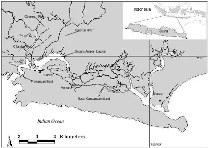
Figure 1. Map of the Segara Anakan ecosystems, Cilacap Regency, Java.
Material and Methods
1. Study Area
The Segara Anakan coastal ecosystem is located in the south-western part of Central Java (108o46’ – 109o03’ E; 7o34’ – 7o47’ S), west of Cilacap city. This ecosystem is protected from the open ocean by a barrier island called Nusakambangan.
Segara Anakan Lagoon
Indian Ocean
Cilacap Nusa Kambangan Island
Cikonde River Cibereum River
Citanduy River
Indonesia
Java
Motean Klaces
The climate at Segara Anakan is tropical and humid, with the southeast monsoon dry season during the months (April – October) and the northwest monsoon rainy season (November – March). Rainfall during the rainy season exceeds 300 mm/month and falls to 100 mm/month or less in the dry season (Tomascik et al., 1997). Tides are semidiurnal
with an amplitude ) within the lagoon is 1.48 m in average (White et al., 1989). The area of
the present study included the Segara Anakan lagoon, the rivers Citanduy, Cibeureum and Cikonde in the northern part of lagoon, Motean in the eastern and Klaces in the southern part of the lagoon (Figure 1).
2. Data sets
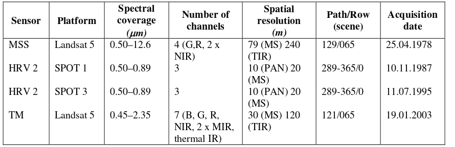
Satellite images were used in this study is listed in Table 1.
Table 1. List of satellite images in this study.
Sensor Platform
The dataset was geometrically corrected through ortho-rectification in order to assure corrections for terrain distortions. The radiometric correction for the Landsat TM data was related to the attenuation of atmospheric effects and was based on the minimum histogram pixel approach (Filho and Paradella, 2002).
Landsat MSS and TM images were registered and resampled to a Universal Transverse Mercator (UTM) coordinate system for zone SUTM 49 on the WGS 1984 projected output image composed of 30 x 30 m pixels with an RMS error of less than 1.0 pixel. SPOT images were also registered and resampled to a UTM (SUTM 49) projected output image composed of 20 x 20 m pixels with an RMS error of less than 1.0 pixel, was obtained from the Biotrop Training and Information Centre (BTIC).
3.2. Classification, accuracy assessment, mangrove mapping and change detection
Supervised classification with a maximum likelihood algorithm (available in ERMapper 5.5) was used in this study, because this classification algorithm produces consistently good results for most habitat types (Donoghue and Mironnet, 2002). The training polygons were digitized on-screen based on terrain knowledge acquired during fieldwork and was distributed throughout the study areas. The pixels in the polygons that were selected as representatives of each class were plotted in spectral space and a visual check was made that all classes could be separated in at least one combination of bands, for ellipses containing 95% of the class pixels.
To increase the size of the sample to be used in classification accuracy assessment, the layer with the field-checked sites was overlaid on the corrected satellite images, and homogeneous polygons with similar spectral reflectance, when viewed in several band combinations, were drawn around those sites. The layer of polygons created using this process was later used for checking the accuracy of the classified map.
Accuracy assessment for the coastal habitat maps from the Segara Anakan ecosystem was based on 37-ground truthing points recorded during the field survey (May 2004 – February 2005). Using ecological information in a Geographic Information System (GIS), one can formulate and apply location and topological (the relation between area-based objects) rules to the classified satellite data to improve the mapping accuracy (Long and Skewes, 1996).
After accuracy assessment, the classified images were exported to GIS facilities to generate the mangrove thematic map. Analysis and quantification of mangrove conversion between the different dates was included in the GIS database. Once both maps had exactly the same number of feature pixels they were subject to a cross-tabular comparison. This indicates the differences in extent of each class and the transitions that had taken place between the two dates. The characterization of land cover change is done using aggregated measurements of area by cover type at both dates and quantifying transitions. The change analysis is limited to these measurements due to the different generalization levels and minimum size of mapped units for the data sources available for the study (1978 – 2003).
Results and Discussion
lying area with a great abundance of fresh water resources of the former mangrove area occurred compared to the other parts of the mangrove.
(a) (b)
(c) (d)
Legend:
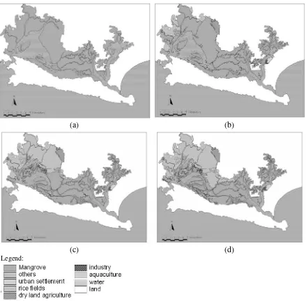
Figure 2. Temporal and spatial conversion of mangrove forest of Segara Anakan since 1978 (a); 1987 (b); 1995 (c) and 2003 (d).
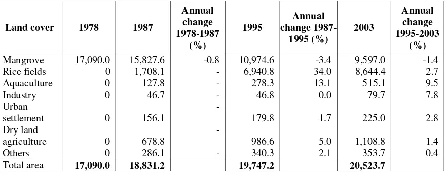
Table 2. Temporal change in land cover area (in ha) in Segara Anakan.
Table 3. Temporal trajectory of mangrove conversion in Segara Anakan.
Land cover 1987
New mangrove areas 1,741.1 193.5 916.0 114.5 776.5 97.1
Mangrove, converted 3,003.6 333.7 5,769.0 721.1 2,154.1 269.3
Rice fields 1,708.1 189.8 5,232.7 654.1 1,703.6 213.0
• Mangrove (no changed): this refers to the area that remained covered by mangroves over the reference
time
• New mangrove: this refers to mainly former lagoon area of mud flats that due to siltation got habitable
for mangroves
• Mangrove converted: former mangrove area, which was converted into a different land use types.
Figure 3 shows a decrease of the total mangrove area where goes opposite to the increase of the agricultural area. While mangroves covered about 17,090 ha in 1978 and rice fields was not existent at that time, both mangroves and rice fields covered about the same area in 2003 (ca 9,000 ha). The increase of other land uses such as aquaculture, industry, urban settlement, dry land agriculture and others did not significantly change the extent of the converted mangroves area because of new mangrove area were building up. During the period of 1995 to 2003 (for example) the mangrove area converted into land use excluding rice fields was 450.5 ha, while at the same time new mangrove area of about 776.5 ha.
-3.4% per year to only -1.4% per year. It can be assumed that this decline resulted (at least in part) from the projects CRMP and SACDP conducted in Segara Anakan, as mentioned above.
Figure 3. Extent of change from 1978 to 2003 by land use types.
The land cover and land use changes described, particularly the great reduction of the original mangrove forest have changed the ecosystems of and around the Segara Anakan lagoon significantly. It should be asked if these changes considered to the ecosystem and to the local resource users and other stakeholders of if these changes may also provide new opportunity and benefits.
The result of these changes has been an increase in the diversity and complexity of the social, economic, and environment. The local economy of the three fishing communities located in the estuary has been highly dependent on the estuary fisheries. Others land use activities around the farmers’ homes are generally more diverse than in the fishing communities, including home gardens and fishponds. Home garden crops, or
palawija, are mainly located on built up areas. Small non-intensive fishponds have been
constructed around some of the houses.
Economic opportunities arose from rice fields development, mainly from the greater number of income generating activities, including farm labour, harvester, garden and dry land crops, and fishponds. While rice has been the dominant agricultural activity in Segara Anakan, the cultivation of other agriculture products, generally cash crops, occurs on a much smaller scale. These crops include soybean, sugar production, sorghum, fruit and vegetables, and are often sold to supplement the household income. The cultivation of the rice fields is managed through various labour arrangements, notably, farmers working the land themselves, hiring labour, and/or help from family members.
While producing economic benefits, aquaculture development has also been
associated with environmental degradation on Segara Anakan, including the conversion of
mangroves and pollution of the surrounding waters. Mangrove conversion may lead to several problems such as reduced catch yields of commercially important species; reduced biodiversity; loss of habitats and nursery areas; coastal erosion; loss in productivity; acidification; pollution; and alteration of water drainage patterns. High population pressure in the coastal areas near Segara Anakan and elsewhere in Java has led to the conversion of many mangrove areas to other uses, including infrastructure, aquaculture and rice growing etc.
The loss of biodiversity in mangrove-converted area in Segara Anakan has been reported since 1980s (Sastranegara et al., 2003). Monthly fluctuation of intertidal crab
diversity was more constant in the undisturbed area with a high mangrove coverage (90%) compared to the crab hunting, the logging and the prawn pond area with mangrove coverage of 89%, 33% and 0%, respectively. Sjöling et al. (2005) reported that the nutrient
and bacteria diversity are significantly different (lower) in the deforested mangrove areas. Issues of sustainable development of the land use/cover changes were addressed in terms of economic viability, social equity and ecological integrity. Overall, the current changes have produced both constraints and opportunities for sustainable development. This paper provides information on land use/cover change for resources sustainable development, that would be related with the further papers about the assessment of the Segara Anakan natural resources stocks and uses by using the models Ecopath and Ecosim.
Conclusions
The results of this study show that there have been important mangrove conversions in Segara Anakan from 1978 to 2003 with the largest portion of mangroves converted into rice fields (8,644.4 ha or 42.1%) followed by 5.4% to dry land agriculture (about 1,108.8 ha), 2.5% to aquaculture (about 515.1 ha), 1.7% to other land uses (about 353.7 ha), 1.1% to urban settlement (about 225 ha) and 0.4% to industry area (about 79.9 ha). The mangrove area has continually decreased by 1.4% per year since the last decade. This process may lead to several negative impacts such as reduced fish catch, reduced biodiversity, loss of productivity and habitat as a spawning, nursery and feeding ground. Rapid human population growth and sedimentation are the most important causes of the mangrove conversions in the study area.
Acknowledgements
The authors want to thank the SPICE project, Center for Tropical Marine Ecology (ZMT) Bremen, Deutscher Akademischer Austauschdienst (DAAD), German Ministry of Education and Research (BMBF) and University of Jenderal Soedirman, Purwokerto, for their support during this study; Biotrop Training and Information Center (BTIC) Bogor for images support.
References
Alongi, D.M., Pfitzner, J., Trott, L.A., Tirendi, F., Dixon, P., Klumpp, D.W., 2005. Rapid sediment accumulation and microbial mineralization in forests of the mangrove
Kandelia candel in the Jiulongjiang Estuary, China. Estuarine, Coastal and Shelf
Science 63, 605-618
Ardli, E.R., Widyastuti, A., 2001. Application of NDVI analysis from Landsat TM and SPOT images for monitoring and detection of mangrove damages at Segara Anakan Cilacap, Central Java. (in Bahasa Indonesia). DUE-like Project Unsoed, Purwokerto. Blasco, F., Saenger, P., Janodet, E., 1996. Mangroves as indicators of coastal change.
Catena 27, 167-178.
BPKSA (Badan Pengelola Kawasan Segara Anakan), 2003. Laporan pelaksanaan proyek konservasi dan pembangunan Segara Anakan. Lokakarya Status, Problem dan Potensi Sumberdaya Perairan dengan Acuan Segara Anakan dan DAS Serayu. Purwokerto.
Donoghue, D.N.M., Mironnet, N., 2002. Development of an integrated geographical information system prototype for coastal habitat monitoring. Computer & Geosciences 28, 129-141.
Dudley, R.G, 2000. Segara Anakan Fisheries Management Plan. Segara Anakan Conservation and Development Project. Component B&C. Consultant’s Report.
FAO, 2003. State of the world forest. FAO, Rome.
Filho, P.W.S., Paradella, W.R., 2002. Recognition of the main geobotanical features along the Bragança mangrove coast (Brazilian Amazon Region) from Landsat TM and RADARSAT-1 data. Wetlands Ecology and Management 10,123-132.
Long, B.G., Skewes, T.D., 1996. A technique for mapping mangrove with Landsat TM satellite data and geographic information system. Estuarine, Coastal and Shelf Sciences 43, 373-381.
Manson, F.J., Loneragan, N.R., Harch, B.D., Skilleter, G.A., Williams, L., 2005. A broad-scale analysis of links between coastal fisheries production and mangrove extent: A case-study for northeastern Australia. Fisheries Research 74(1-3), 69-8.
Mumby, P.J., Skirving, W., Strong, A.E., Hardy, J.T., LeDrew, E.F., Hochberg, E.J., Stumpf, R.P., David, L.T., 2004. Remote sensing of coral reefs and their physical environment. Marine Pollution Bulletin 48, 219-228.
Mumby, P.J., Green, E.P., Edwards, A.J., Clark, C.D., 1999. The cost-effectiveness of remote sensing for tropical coastal resources assessment and management. Journal of Environmental Management 55, 157-166.
Novelli Y.S., CintroÂn-Molero, G., Soares, M.L.G., De-Rosa, T., 2000. Brazilian mangroves. Aquatic Ecosystem Health and Management 3, 561-570.
Primavera, J.H, 1998. Mangroves as nurseries: Shrimp populations in mangrove and non-mangrove habitats. Estuarine, Coastal and Shelf Science 46, 457–464
Purba, M. 1991. Impact of high sedimentation rates on the coastal resources of Segara Anakan, Indonesia, p. 143-152. In L.M. Chou, T.-E. Chua, H.W. Khoo, P.E. Lim,
J.N. Paw, G.T. Silvestre, M.J. Valencia, A.T. White and P.K. Wong (Eds.) Towards an Integrated management of tropical coastal resources. ICLARM Conference Proceedings 22, 455p. National University of Singapore, Singapore; and International Center for Living Aquatic Resources Management, Philippines.
Sjöling, S., Mohammed, S.M., Lyimo, T.J., Kyaruzi, J.J., 2005. Benthic bacterial diversity and nutrient processes in mangroves: impact of deforestation. Estuarine, Coastal and Shelf Science 63, 397–406.
Soemodihardjo, S., Suroso, Suyarso, 1991. The mangroves of Segara Anakan: An assessment of their condition and prospects, p. 213-222. In L.M. Chou, T.-E. Chua,
H.W. Khoo, P.E. Lim, J.N. Paw, G.T. Silvestre, M.J. Valencia, A.T. White and P.K. Wong (Eds.) Towards an Integrated management of tropical coastal resources. ICLARM Conference Proceedings 22, 455p. National University of Singapore, Singapore; and International Center for Living Aquatic Resources Management, Philippines.
Tomascik, T., Mah, A.J., Nontji, A., Moosa, M.K. 1997. The ecology of the Indonesian seas. Part II chapter 13-23. Periplus Editions, Singapore.
Vasconcelos, M.J.P., Mussa´Biai, J.C., Arau´jo, A., Diniz, M.A., 2002. Land cover change in two protected areas of Guinea-Bissau (1956–1998). Applied Geography 22, 139– 156.
Weiers, S., Block, M., Wissen, M., Rossner, G., 2004. Mapping and indicator approaches for the assessment of habitats at different scales using remote sensing and GIS methods. Landscape and Urban Planning 67, 43-65.
White, A.T., Christie, P., D’Agnes, H., Lowry, K., Milne, N., 2005. Designing ICM project for sustainability: Lesson from the Philippines and Indonesia. Ocean & Coastal Management 48, 233-251.
White, A.T., Martosubroto, P., Sadorra, M.S.M., Eds. 1989. The coastal environmental profile of Segara Anakan-Cilacap, South Java, Indonesia. ICLARM Technical Reports on Coastal Area management Series no. 25. International Centre for Living Aquatic Resources Management, Manila.
ILLEGAL LOGGING OF MANGROVES IN SEGARA ANAKAN CILACAP: A CONSERVATION CONSTRAINT
by
Moh. Husein Sastranegara 1, Edy Yuwono 1, Purnama Sukardi 2
1Faculty of Biology, University of Jenderal Soedirman, Purwokerto, Indonesia
2Faculty of Science and Technique, University of Jenderal Soedirman, Purwokerto, Indonesia
Introduction
In general, tropical forest areas are in Central America, Central Africa, Southeast Asia, and the islands of Pacific Oceans. The biggest forest is in Southeast Asia, especially Indonesia which has 120 millions ha in areas (Haeruman, 1980). Segara Anakan Cilacap has 9,600 ha in the number of mangroves (Erwin Ardli Riyanto, this volume). The role of mangroves is as the habitat of living organisms (Sasekumar et al., 1992; Marshall, 1994;
Ewell et al., 1998).
Based on the forest map of the State Forest Corporation, mangroves in Segara Anakan Cilacap is in “Estuarine Forest Corporation Class“ (Perum Perhutani, 1993). Mangrove or estuarine forests grow in protected coast, river mouth or lagoon. Their distribution and composition are not dependent upon climate, but edaphic factor (soil type) and tide. Structure of mangroves is simple and consists of one layer of canopy and the small number of species (Bupati Cilacap, 2001b). Unfortunately, illegal logging of mangroves is still continuing and will disturb the available of mangroves in Segara Anakan Cilacap. Yuwono et al., (2007) declared that mangroves in Segara Anakan Cilacap is
considered to be the largest remaining single mangrove in the south coast of Java.
Therefore, the Segara Anakan Management Areas (108°46´ – 109°03´ E and 7°35´ – 7°48’ S) is divided into the West Swamp-managed Areas (Swamp- production Zones: 108°46´ E – 108°53´ E and 7°35´ S – 7°43’ S) and the East Swamp-managed Areas (protected Zones: 108°53´ E – 108°58´ E and 7°39´ S – 7°44’ S; and Swamp-production Zones: 108°57´ E – 109°02´ E and 7°40´ S – 7°45’ S) by the government of Cilacap (Bupati Cilacap, 2000; GIS Lab PMO – SACDP, 2000). Mangroves in Segara Anakan Cilacap are managed by the Central Java State Forest Corporation, Forestry Department.
Swamp-production zones is in the West and the East swamp-managed areas of Segara Anakan Cilacap that silvofishery leading to the complete clear-cutting of mangrove trees (as in the prawn pond areas) leads to a highly impoverished crab community both in terms of crab individual and diversity (Sastranegara et al., 2003). In general, the mangrove
destruction has marked effects on species diversity (Hobbs and Huenneke, 1992). Sucgang
et al., (1994) clarified that conversion of mangrove into prawn ponds resulted in coastal
erosion producing a retreating shoreline, inundated wetlands, salt water intrusion, depletion on the supply of river sediments, disastrous flooding, damages to infrastructures, loss of property, and mangrove destruction. Then, mangrove destruction makes a decreasing of species diversity. Hampicke (1994) reported that nature can be valued in its own right or as an instrument for the benefit of humankind which substantiate conservation as moral duty. This background inspires the purpose of research which is as follows:
So far, the research can provide useful information on the illegal logging as mangrove constraint in Segara Anakan Cilacap for conservation suggestion efforts which is done by the Central Java State Forest Corporation, Forestry Department, the Republic of Indonesia.
Methods
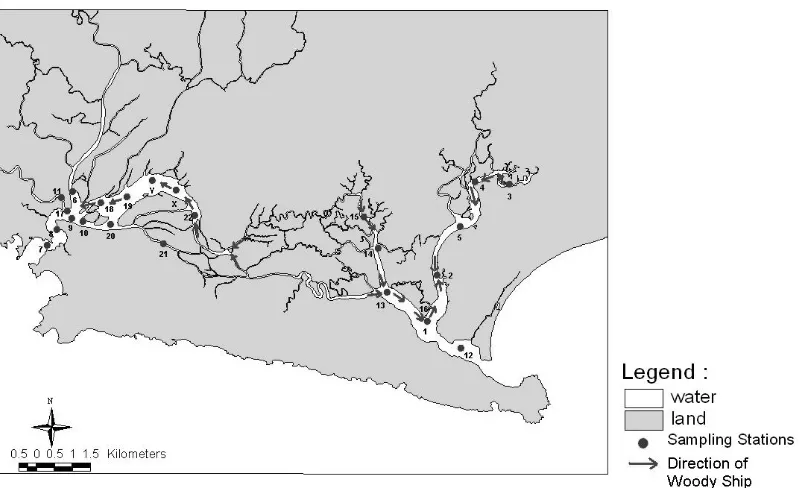
Survey method was taken in the Segara Anakan Management Areas in the period of half way between spring and neap tidal periods every month from March 2006 to May 2006. The Segara Anakan Management Areas is divided into the West Swamp-managed Areas (Swamp-production Zones: route of field trip is from station 21, Y, 24, 22, X, Y, 19, 18, 20, 17, 6, 17, 11, 17, 8, 7, 8, 7, 8, 9, 10, 20, 21 to 24; or from station Y, 19, 10, 17, 6, 17, 11, 17, 11, 17, 8, 7, 8, 9, 10, 20, 24, X, 26 to 21) and the East Swamp-managed Areas (Swamp-protected Zones and Swamp-production Zones: route of field trip is from station 2, 5, 4, 3, 4, 5, 2, 1, 12, 1, 13, 14, 15, 14 to 13).
The kind of species that is cut by local people in Segara Anakan Cilacap is known by identification of various parts of felled tree (Ng and Sivasothi, 1999; Tomlinson, 1999). The average of felled tree per days in Segara Anakan Cilacap is known by the multiplication between the average of number of wooden ship per days and the average of number of volume of felled tree inside wooden ship. The source of felling of trees in Segara Anakan Cilacap is known by route of field trip in accordance with Science for the Protection of Indonesian Coastal Marine Ecosystems (SPICE) as BMBF/DKP/RISTEK Project in the year of 2003-2007 route from Sleko at the East Swamp-managed Areas at
09.00 a.m. to the West Swamp-managed Areas. All data is described by descriptive approach.
Results and Discussion
Mangroves in Java and Kalimantan islands have 29 species in number (Tomlinson, 1999) and Cilacap Regency has 26 species (Cilacap Regent, 2001b). Therefore, Segara Anakan Cilacap has a good diversity potential. ASEAN/ US CRMP (1992) was worried about illegal logging of mangroves in Segara Anakan Cilacap affecting the decreasing of aquatic organism diversity and catching effort of fishes per year. Sastranegara (2004) showed that Segara Anakan Cilacap has 16 species at the East Swamp-managed Areas.
The result of research showed that Rhizophora apiculata, R. mucronata, and Bruguieragymnorrhiza was cut by local people. R. apiculata and R. mucronata tend to use
for charcoal and firewood, whereas B. gymnorrhiza is for building material needs. Various
parts of felled tree were cut with an adze and machete in back mangroves at low tide. At high tide, it was transported by wooden ships. Therefore, the condition of mangrove is a good enough in front mangroves and the other way of back mangroves.
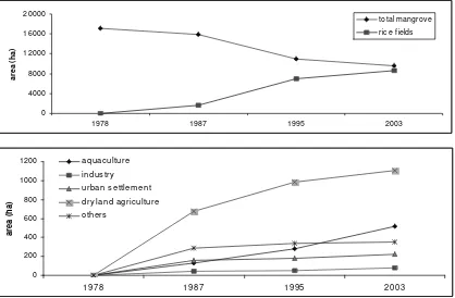
ship is same. Therefore, the average of felled tree in Segara Anakan Cilacap is 8.98 m3 per day. It means that there is increasing number of the average as much 158.46 percent. If the average of felled tree in Segara Anakan Cilacap which is 14.23 m3 per days (5,122.80 m3 per year) is continue, the mangrove area will continually decreased.
Table 1. The number of wooden ship bringing the various parts of felled tree on 2005 (a) and 2006 (b).
(a)
Month March 2005 April 2005 May 2005
Date 11 12 26 27 10 11 25 26 9 10 24 25
No. wooden
ship 7 6 6 6 7 6 6 8 6 5 8 6
No.station/time
of occurence 02/11.50 21/10.16 21/10.35 18/14.50 02/11.55 21/10.14 21/10.45 21/10.18 01/12.56 21/10.32 01/09.55 22/12.45
01/12.15 21/10.16 18/13.50 19/15.00 02/11.55 21/10.17 18/12.15 18/11.45 15/14.07 19/13.52 13/11.16 22/13.03
15/14.18 18/13.40 19/14.00 19/15.00 15/14.42 18/13.59 18/12.15 19/12.11 15/14.11 22/15.00 13/11.18 22/13.24
15/14.18 18/13.40 19/14.10 22/15.40 14/15.59 19/14.53 19/14.33 19/12.11 14/14.27 13/16.57 21/13.33 22/13.24
14/14.44 19/14.10 22/15.20 22/15.40 13/16.30 22/15.30 22/15.44 22/14.00 13/15.03 01/17.15 21/13.40 13/16.40
14/14.50 22/15.00 22/15.20 13/17.45 01/16.45 13/17.58 13/18.05 13/17.06 01/16.55 21/13.40 02/17.59
13/15.19 01/16.45 13/17.06 18/14.10
01/17.40 19/14.19
(b)
Month March 2006 April 2006 May 2006
Date 16 17 14 15 9 10
Wooden
ship 11 9 6 12 9 14
Station/time 13/15.15 X/07.03 03/10.24 22/06.28 03/10.15 24/06.30
04/11.14 19/07.19 05/11.30 19/08.12 12/13.16 18/08.18 02/11.50 18/08.45
20/09.20 01/13.10 20/09.35
10/10.35 15/15.17 10/11.08
11/11.57 11/13.17
17/12.23
06/13.05
Therefore, the average of felled trees per day in Segara Anakan Cilacap is faster than its growth. Then, we cannot find the big mangroves because they grow slowly. For example, mangroves in the village of Tritih Kulon, the district of Cilacap Utara, the regency of Cilacap which is established in 1980’s has only 7.5 m in height. Haeruman (1980) showed that the hole of canopy cover needs 200 years for their recovery.
(a)
Figure 1. The number of wooden ship in average in the year of 2005 (a) and 2006 (b)
Figure 3. The direction of wooden ships
Based on the deep interview to local people, there are smokestacks at station 2 for burning mangrove trees in relation to produce charcoals. At least, it can produce charcoal as much 12 m3 per days which is coming from three trucks per six days. The size of truck is 6 m in length x 2 m in width x 2 m in height. It means that the charcoal is as much 12 m3 per days for business needs and 2.23 m3 per days for local needs. The number of 2.23 m3 per days is calculated from the average of felled tree in Segara Anakan Cilacap as much 14.23 m3 per days minus 12 m3 per days.
Now, Scientist and politicians agreed that biological diversity is in crisis due to human activities (Van-Wright et al., 1991). Human activities in relation to mangrove have
been regulated in Cilacap. For example, the illegal logging of mangroves is an infraction of roles as follows:
1. Peraturan Daerah Kabupaten Cilacap Nomor: 17 Tahun 2001 about the mangrove management in Segara Anakan Cilacap, especially article 11 (Bupati Cilacap, 2001b); 2. Peraturan Daerah Kabupaten Cilacap Nomor: 6 Tahun 2001 about the art plan of
Segara Anakan, Cilacap Areas, especially article 14 (Bupati Cilacap, 2001a);
3. Peraturan Daerah Kabupaten Cilacap Nomor: 23 Tahun 2000 about Segara Anakan Cilacap border line, especially article 13 (Bupati Cilacap, 2000).
Conclusions
Rhizophora apiculata, R. mucronata, and Bruguieragymnorrhiza was cut by local
mangroves. The kind of species R. apiculata and R. mucronata tend to use for charcoal and
firewood, whereas B. gymnorrhiza is for building material needs. The illegal logging of
mangroves is a constraint for conservation tasks because the diversity of aquatic organisms decreases in Segara Anakan Cilacap. Therefore, natural resource and environmental management should be done as a holistic perspective.
References
ASEAN/ US CRMP. 1992. The integrated management plan for Segara Anakan Cilacap, Central Java, Indonesia. International Centre for Living Aquatic Resources Management Tech. Rep. 34, Manila.
Bupati Cilacap. 2000. Peraturan daerah kabupaten Cilacap Nomor: 23 Tahun 2000 tentang penetapan batas kawasan Segara Anakan. Pemerintah Daerah Kabupaten Cilacap, Cilacap.
____________. 2001a. Peraturan daerah kabupaten Cilacap Nomor: 6 Tahun 2001 tentang Rencana tata ruang kawasan Segara Anakan. Pemerintah Daerah Kabupaten Cilacap, Cilacap.
____________. 2001b. Peraturan daerah kabupaten Cilacap Nomor: 17 Tahun 2001 tentang Pengelolaan hutan mangrove di kawasan Segara Anakan. Pemerintah Daerah Kabupaten Cilacap, Cilacap.
Ewell, K.C., Twilley, R.R., Ong, E.O., 1998, Different kinds of mangrove forests provide different goods and services. Global Ecology and Biogeography Letters 7, 83-94. GIS Lab PMO – SACDP. 2000. Land use of Segara Anakan Cilacap management areas
and number of areas. GIS Lab PMO – SACDP, Cilacap.
Haeruman, H., 1980. Hutan sebagai lingkungan hidup. Kantor Menteri Negara Pengawasan Pembangunan dan Lingkungan Hidup, Jakarta.
Hampicke, U., 1994. Ethichs and economics of conservation. Biological Conservation 67, 219-231.
Hobbs, R.J., Huenneke, L.F., 1992. Disturbance, diversity, and invasions: Implications for conservation. Conservation Biology 6(3), 324-337.
Marshall, N., 1994. Mangrove conservation in relation to overall environmental considerations. Hydrobiologia 285, 303-309.
Ng, P.K.L., Sivasothi, N. 1999. A guide to the mangroves of Singapore 1. Singapore Science Centre, Singapore.
Perum Perhutani. 1993. A glance at Perum Perhutani (State Forest Corporation) Indonesia. Perusahaan Umum Perhutanan Indonesia, Jakarta.
Sasekumar, A., Chong, V.C., Leh, M.U., Cruz, R.D., Mangroves as habitat for fish and prawns. Hydrobiologia 247, 195-207.
Sastranegara, M.H. 2004. The impact of forest use on the intertidal crab community in managed mangroves of Cilacap, Central Java, Indonesia. Cuvillier, Göttingen. Sastranegara, M.H., Fermon, H., Mühlenberg, M. 2003. Diversity and abundance of
intertidal crabs at the East swamp-managed areas in Segara Anakan Cilacap, Central Java, Indonesia. Proceedings of Deutcher Tropentag 2003: Technological
and Institutional Innovations for Sustainable Development in Göttingen, October 8-10, 2003.
Sucgang, B.L., Cabantog, A.V., Domasig, W.F., 1994. Assessment of the coastal degradation of northeastern Leyte. Ecosystems and Nat. Res. 4(1), 1-18.
Tomlinson, P.B. 1999. The Botany of mangroves. Cambridge University Press, Cambridge.
Van-Wright, R.I., Humphries, C.J., Williams, P.H., 1991. What to protect?- Systematics and the agony of choice. Biological conservation 55, 235-254.
ENVIRONMENTAL CONDITIONS IN THE SEGARA ANAKAN LAGOON, JAVA, INDONESIA
by
Tim Jennerjahn1, Peter Holtermann2, Insa Pohlenga1 & Bushra Nasir1
1Center for Tropical Marine Ecology, Bremen, Germany
2 University of Rostock, Rostock, Germany
Introduction
Segara Anakan is one of the last remaining mangrove/lagoon ecosystems on the Indonesian island of Java, one of the most densely populated areas in the world. For more than 400 years it has been a resource nourishing and providing income to the local population. However, the natural resources and hence socio-economic goods and services of the mangrove-fringed lagoon are endangered by degradation and pollution through unsustainable land use practices in the hinterland, overexploitation of its resources and pollution from industry and households. The lack of understanding of the ecosystem structure and functions and in consequence the lack in public awareness of the ecological value of the mangroves led to the failure of past management programmes. Mangroves do not only provide goods like, e.g. wood, or serve as nursery of many commercially important species. They are also important physical barriers providing protection to tropical coastlines, a lesson learned from the Tsunami in December 2004 the destructive effects of which would have been much less, for example, in Aceh if the mangroves had not been cut off.
Segara Anakan is a mangrove-fringed shallow coastal lagoon located in south central Java which is under the influence of manifold natural and anthropogenic factors. The tropical humid climate is governed by the monsoons. Major part of the annual precipitation of 3,000-3,500 mm falls during months November to March (White et al.,
1989; Whitten et al., 1996). The hydrology of the lagoon is governed by seasonally
varying river runoff mainly of the Citanduy River in the west and tidal exchange with the Indian Ocean. Major threats to ecosystem functions of the lagoon are high sediment and nutrient inputs by the Citanduy River, mangrove degradation, land use change and industrial and urban pollution. The mangrove area has been drastically reduced major part of which has been converted to cropland. Major land use in the area is agriculture, mainly cultivation of irrigated rice. All these are impairing natural ecosystem functions and hence living resources which to a large extent form the economic potential of the lagoon. Mangroves and tidal flats are highly important sites for the biogeochemical cycling of elements and as habitat for numerous benthic organisms (Alongi, 1998). High sediment input from the Citanduy due to unsustainable land use practices in the river catchment leads to changes in the distribution of water and land-covered area, alters or destroys habitats of benthic organisms and affects benthic-pelagic coupling and carbon and nutrient cycling.
investigations on the environmental conditions in the lagoon and its surroundings obtained during the first phase of SPICE (2003-2007).
Results and Discussion
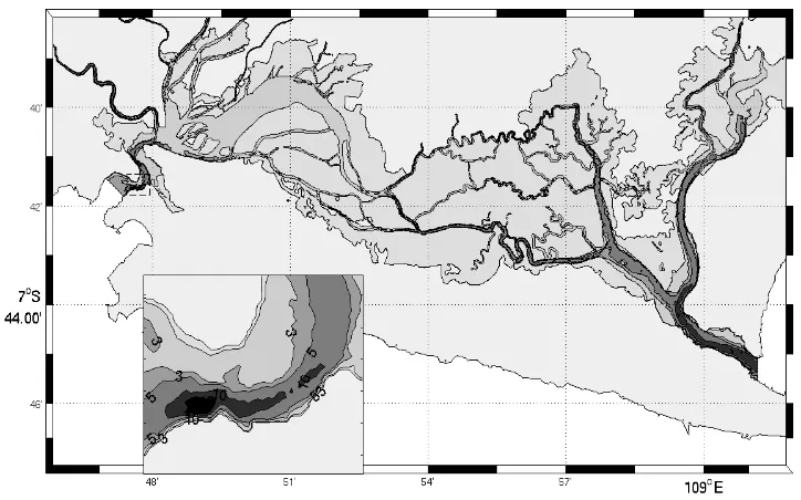
Bathymetry and hydrodynamics
Recent information on bathymetry and hydrodynamics of the lagoon and discharge of the Citanduy River were obtained from tide gauges and ADCP (Acoustic Doppler Current Profiler) measurements and modelling with the open source GETM model (General Estuarine Ocean Model, www.getm.eu). The central and western parts of the lagoon are extremely shallow with water depths often <2 m. Only in the westernmost part from the Citanduy River mouth to the Indian Ocean water depths are greater with a maximum depth of >10 m in the Plawangan channel (Figure 1). In the eastern lagoon water depths of 5-10 m are recorded in the Sapuregel and Donan branches because of little freshwater and sediment input. Near Cilacap port facilities and in the channel connecting the lagoon to the Indian Ocean water depth is around 10 m also because of dredging of the navigation channel. Preliminary results of short-term flux measurements indicate an average discharge of the Citanduy River of 140 m3 s-1 (range 80-300 m3 s-1) and an average outflow to the Indian Ocean through the Plawangan channel of 555 m3 s-1 (range 0-1200 m3 s-1). Measurements and model calculations indicate an E-W exchange in the range of 0-400 m3 s-1. Model calculations indicate a westward propagation of the tidal wave in the lagoon with a delay of about one hour in its western part. Freshwater input into the lagoon increases considerably during the rainy season, particularly in the western part. While saltwater input is low during that time the incoming flood tide is pushing the river plume towards the center of the lagoon thereby possibly enhancing sediment deposition during the rainy season. It appears that tidal dynamics are an important control of the dispersal and deposition of dissolved and particulate substances in the lagoon.
Dissolved inorganic nutrients
Results of dissolved inorganic nutrient analyses indicate a large spatio-temporal variability in the lagoon. Dissolved silicate was in the range of 10-230 µM between May 2004 and February 2005 while dissolved phosphate was mostly <1 µM. Dissolved inorganic nitrogen (DIN) ranged between 4-40 µM and displayed an W-E gradient with maximum DIN in the Citanduy River and a decrease in concentration towards the East (Figure 2). Maximum concentration in the river and its eastward decrease appear to reflect the land use and hydrology pattern of the lagoon's environs. More than half of the land use in the Segara Anakan region is agriculture, predominantly the cultivation of rice under irrigation and fertilizer application (Yuwono et al., 2007). The observed DIN pattern
indicates that major part of the nitrogen probably originated from agricultural soils and was introduced into the lagoon by the Citanduy River. However, the observed DIN concentrations (i) do not indicate 'nutrient pollution' and eutrophication and (ii) the set of data existing as yet has a preliminary character, because it does not account for tidal variation and the spatial coverage of the lagoon is still inadequate for an overall assessment and budgeting of nutrients in the lagoon.
Figure 2. Concentration of dissolved inorganic nitrogen (DIN = nitrate + nitrite + ammonium) in the Citanduy River and the western (Area 1), central (Area 2) and eastern (Area 3) parts of the Segara Anakan lagoon between May 2004 and February 2005. Values displayed are regional averages not accounting for tidal variation which may be a substantial factor for the observed amplitude of changes.