Editor-in-Chief
Further volumes of this series can be found on our homepage: springer.com
Vol. 113. Gemma Bel-Enguix, M. Dolores Jim´enez-L´opez and Carlos Mart´ın-Vide (Eds.)
New Developments in Formal Languages and Applications,2008 ISBN 978-3-540-78290-2
Vol. 114. Christian Blum, Maria Jos´e Blesa Aguilera, Andrea Roli and Michael Sampels (Eds.)
Hybrid Metaheuristics,2008 ISBN 978-3-540-78294-0
Vol. 115. John Fulcher and Lakhmi C. Jain (Eds.) Computational Intelligence: A Compendium,2008 ISBN 978-3-540-78292-6
Vol. 116. Ying Liu, Aixin Sun, Han Tong Loh, Wen Feng Lu and Ee-Peng Lim (Eds.)
Advances of Computational Intelligence in Industrial Systems, 2008
ISBN 978-3-540-78296-4 Vol. 117. Da Ruan, Frank Hardeman and Klaas van der Meer (Eds.)
Intelligent Decision and Policy Making Support Systems,2008 ISBN 978-3-540-78306-0
Vol. 118. Tsau Young Lin, Ying Xie, Anita Wasilewska and Churn-Jung Liau (Eds.)
Data Mining: Foundations and Practice,2008 ISBN 978-3-540-78487-6
Vol. 119. Slawomir Wiak, Andrzej Krawczyk and Ivo Dolezel (Eds.)
Intelligent Computer Techniques in Applied Electromagnetics, 2008
ISBN 978-3-540-78489-0
Vol. 120. George A. Tsihrintzis and Lakhmi C. Jain (Eds.) Multimedia Interactive Services in Intelligent Environments, 2008
ISBN 978-3-540-78491-3
Vol. 121. Nadia Nedjah, Leandro dos Santos Coelho and Luiza de Macedo Mourelle (Eds.)
Quantum Inspired Intelligent Systems,2008 ISBN 978-3-540-78531-6
Vol. 122. Tomasz G. Smolinski, Mariofanna G. Milanova and Aboul-Ella Hassanien (Eds.)
Applications of Computational Intelligence in Biology,2008 ISBN 978-3-540-78533-0
Vol. 123. Shuichi Iwata, Yukio Ohsawa, Shusaku Tsumoto, Ning Zhong, Yong Shi and Lorenzo Magnani (Eds.)
Communications and Discoveries from Multidisciplinary Data, 2008
ISBN 978-3-540-78732-7 Vol. 124. Ricardo Zavala Yoe
Modelling and Control of Dynamical Systems: Numerical Implementation in a Behavioral Framework,2008 ISBN 978-3-540-78734-1
Vol. 125. Larry Bull, Bernad´o-Mansilla Ester and John Holmes (Eds.)
Learning Classifier Systems in Data Mining,2008 ISBN 978-3-540-78978-9
Vol. 126. Oleg Okun and Giorgio Valentini (Eds.) Supervised and Unsupervised Ensemble Methods and their Applications,2008
ISBN 978-3-540-78980-2
Vol. 127. R´egie Gras, Einoshin Suzuki, Fabrice Guillet and Filippo Spagnolo (Eds.)
Statistical Implicative Analysis,2008 ISBN 978-3-540-78982-6
Vol. 128. Fatos Xhafa and Ajith Abraham (Eds.)
Metaheuristics for Scheduling in Industrial and Manufacturing Applications,2008
ISBN 978-3-540-78984-0
Vol. 129. Natalio Krasnogor, Giuseppe Nicosia, Mario Pavone and David Pelta (Eds.)
Nature Inspired Cooperative Strategies for Optimization (NICSO 2007),2008
ISBN 978-3-540-78986-4
Vol. 130. Richi Nayak, Nikhil Ichalkaranje and Lakhmi C. Jain (Eds.)
Evolution of the Web in Artificial Intelligence Environments, 2008
ISBN 978-3-540-79140-9
Vol. 131. Roger Lee and Haeng-Kon Kim (Eds.) Computer and Information Science,2008 ISBN 978-3-540-79186-7
Vol. 132. Danil Prokhorov (Ed.)
Computational Intelligence in Automotive Applications,2008 ISBN 978-3-540-79256-7
Richard J. Duro
(Eds.)
Computational Intelligence
for Remote Sensing
Universidad Pais Vasco Facultad de Inform´atica 20018 San Sebastian Spain
e-mail: [email protected] Richard Duro
Universidad de A Coru˜na Grupo Integrado de Ingenier´ıa Escuela Polit´ecnica Superior c/ Mendiz´abal s/n
15403 Ferrol (A Coru˜na) Spain
e-mail: [email protected]
ISBN 978-3-540-79352-6 e-ISBN 978-3-540-79353-3 DOI 10.1007/978-3-540-79353-3
Studies in Computational Intelligence ISSN 1860-949X Library of Congress Control Number: 2008925271
c
2008 Springer-Verlag Berlin Heidelberg
This work is subject to copyright. All rights are reserved, whether the whole or part of the material is concerned, specifically the rights of translation, reprinting, reuse of illustrations, recitation, broadcasting, reproduction on microfilm or in any other way, and storage in data banks. Duplication of this publication or parts thereof is permitted only under the provisions of the German Copyright Law of September 9, 1965, in its current version, and permission for use must always be obtained from Springer-Verlag.Violations are liable to prosecution under the German Copyright Law.
The use of general descriptive names, registered names, trademarks, etc. in this publication does not imply, even in the absence of a specific statement, that such names are exempt from the relevant protective laws and regulations and therefore free for general use.
Typeset&Cover Design:Scientific Publishing Services Pvt. Ltd., Chennai, India. Printed on acid-free paper
This book is a composition of diverse points of view regarding the application of Computational Intelligence techniques and methods into Remote Sensing data and problems. It is the general consensus that classification, and related data processing, and global optimization methods are the main topics of Computa-tional Intelligence. Global random optimization algorithms appear in this book, such as the Simulated Annealing in chapter 6 and the Genetic Algorithms pro-posed in chapters 3 and 9. Much of the contents of the book are devoted to image segmentation and recognition, using diverse tools from regions of Computational Intelligence, ranging from Artificial Neural Networks to Markov Random Field modelling. However, there are some fringe topics, such the parallel implemen-tation of some algorithms or the image watermarking that make evident that the frontiers between Computational Intelligence and neighboring computational disciplines are blurred and the fences run low and full of holes in many places.
The book starts with a review of the current designs of hyperspectral sensors, more appropriately named Imaging Spectrometers. Knowing the shortcomings and advantages of the diverse designs may condition the results on some appli-cations of Computational Intelligence algorithms to the processing and under-standing of them Remote Sensing images produced by these sensors. Then the book contents moves into basic signal processing techniques such as compression and watermarking applied to remote sensing images. With the huge amount of remote sensing information and the increasing rate at which it is being produced, it seems only natural that compression techniques will leap into a prominent role in the near future, overcoming the resistances of the users against uncontrolled manipulation of “their” data. Watermarking is the way to address issues of own-ership authentication in digital contents. The enormous volume of information asks also for advanced information management systems, able to provide intel-ligent query process, as well as to provide for cooperative manipulation of the images through autonomously provided web services, streamed through special web portals, such as the one provided by the European Space Agency (ESA).
segmentation, change detection, endmember extraction for spectral unmixing, and feature extraction. Diverse kinds of Artificial Neural Networks, Mathemati-cal Morphology and Markov Random Fields are applied to these tasks. The kind of images are mostly multispectral-hyperspectral images, with some examples of processing Synthetic Aperture Radar images, whose appeal lies in its insensitiv-ity to atmospheric conditions. Two specific applications stand out. One is forest fire detection and prevention, the other is quality inspection using hyperspectral images.
Chapter 1 provides a review of current Imaging Spectrometer designs. They focus on the spectral unit. Three main classes are identified in the literature: filtering, dispersive and interferometric. The ones in the first class only transmit a narrow spectral band to each detector pixel. In dispersive imaging spectrome-ters the directions of light propagation change by diffraction, material dispersion or both as a continuous function of wavelength. Interferometric imaging spec-trometers divide a light beam into two, delay them and recombine them in the image plane. The spectral information is then obtained by performing a Fourier transform.
Chapter 2 reviews the state of the art in the application of Data Compression techniques to Remote Sensing images, specially in the case of Hyperspectral im-ages. Lossless, Near-Lossless and Lossy compression techniques are reviewed and evaluated on well known benchmark images. The chapter includes summaries of pertinent materials such as Wavelet Transform, KLT, Coding and Quantization algorithms, compression quality measures, etc.
Chapter 3 formulates the watermarking of digital images as a multi-objective optimization problem and proposes a Genetic Algorithm to solve it. The two conflicting objectives are the robustness of the watermark against manipulations (attacks) of the watermarked image and the low distortion of the watermarked image. Watermarking is proposed as adding the image mark DCT coefficients to some of the watermarked image DCT coefficients. In the case of hyperspectral images the DCT is performed independently on each band image. The careful definition of the robustness and distortion fitness functions to avoid flat fitness landscapes and to obtain fast fitness evaluations is described.
Chapter 5 reviews some general ideas about Content Based Image Retrieval (CBIR) Systems emphasizing the recent developments regarding Remote Sensing image databases. The authors introduce an approach for the CBIR in collections of hyperspectral images based on the spectral information given by the set of endmembers induced from each image data. A similarity function is defined and some experimental results on a collection of synthetic images are given.
Chapter 6 considers an specific problem, that of sensor deployment when try-ing to build up a wireless sensor network to monitor a patch of land. The Martian exploration is the metaphorical site to illustrate the problem. They propose a formal statement of the problem in the deterministic case (all node positions can be determined). This leads to the formulation of an objective function that can be easily seen to multiple local optima, and to be discontinuous due to the connectivity constraint. Simulated Annealing is applied to obtain (good approx-imations to) the global optimum.
Chapters 7 and 8 are devoted to the study of the efficient parallel implemen-tation of segmenimplemen-tation and classification algorithms applied to hyperspectral images. They include good reviews of the state of the art of the application of mathematical morphology to spatial-spectral analysis of hyperspectral images. Chapter 7 focuses on the parallel implementation of morphological operators and morphology derived techniques for spectral unmixing, feature extraction, unsu-pervised and suunsu-pervised classification, etc. Chapter 8 proposes parallel imple-mentations of Multilayer Perceptron and compares with the morphology based classification algorithms. Specific experiments designed to evaluate the influence of the sample partitioning on the training convergence were carried out by the authors.
Chapter 9 deals with the detection and spatial localization (positioning) of rather elusive but also conspicuous phenomena: the line-shaped weather systems and spiral tropical cyclones. The works are performed on radar data and satellite images and tested on real life conditions. The main search engine are Genetic Algorithms based on a parametric description of the weather system. Kalman filters are used as post-processing techniques to smooth the results of tracking.
Chaper 10 proposes a Wavelet Transform procedure performed on the HSV color space to obtain the primitive features for image mining. A systematic method for decomposition level selection based on the frequency content of each decomposition level image.
Chapter 11 reviews the application of Artificial Neural Networks to land cover classification in remote sensing images and reports results on change detection using the Elmann network trained on sequences of images and of Synthetic Aperture Radar (SAR) data.
sec-ond based on automatic change detection with medium resolution multispectral satellite data.
Chapter 13 focus on the application of image spectrometers to quality control applications. Contrary to remote sensing settings, the imaging device is near the imaged object and the illumination can be somehow controlled. The spectral mixing problem takes also another shape, because aggregations of pixels may be needed to form an appropriate spectrum of a material. The recognition is per-formed applying Gaussian Synapse Neural Networks. 14 extends the application of Gaussian Synapse Neural Networks to endmember extraction.
Chapter 15 is devoted to change detection in Synthetic Aperture Radar (SAR) data. Two automatic unsupervised methods are proposed. One based on the semi-supervised Expectation Maximization (EM) algorithm and the Fisher transform. The second follows a data-fusion approach based on Markov Random Field (MRF) modeling.
Spain Manuel Gra˜na
Richard Duro
Acknowledgments
1 Optical Configurations for Imaging Spectrometers
X. Prieto-Blanco, C. Montero-Orille, B. Couce, R. de la Fuente . . . 1
2 Remote Sensing Data Compression
Joan Serra-Sagrist`a, Francesc Aul´ı-Llin`as. . . 27
3 A Multiobjective Evolutionary Algorithm for Hyperspectral Image Watermarking
D. Sal, M. Gra˜na . . . 63
4 Architecture and Services for Computational Intelligence in Remote Sensing
Sergio D’Elia, Pier Giorgio Marchetti, Yves Coene, Steven Smolders,
Andrea Colapicchioni, Claudio Rosati. . . 79
5 On Content-Based Image Retrieval Systems for Hyperspectral Remote Sensing Images
Miguel A. Veganzones, Jos´e Orlando Maldonado, Manuel Gra˜na . . . 125
6 An Analytical Approach to the Optimal Deployment of Wireless Sensor Networks
J. Vales-Alonso, S. Costas-Rodr´ıguez, M.V. Bueno-Delgado, E. Egea-L´opez, F. Gil-Casti˜neira, P.S. Rodr´ıguez-Hern´andez,
J. Garc´ıa-Haro, F.J. Gonz´alez-Casta˜no . . . 145
7 Parallel Spatial-Spectral Processing of Hyperspectral Images
Antonio J. Plaza. . . 163
8 Parallel Classification of Hyperspectral Images Using Neural Networks
9 Positioning Weather Systems from Remote Sensing Data Using Genetic Algorithms
Wong Ka Yan, Yip Chi Lap. . . 217
10 A Computation Reduced Technique to Primitive Feature Extraction for Image Information Mining Via the Use of Wavelets
Vijay P. Shah, Nicolas H. Younan, Surya H. Durbha, Roger L. King . . . . 245
11 Neural Networks for Land Cover Applications
Fabio Pacifici, Fabio Del Frate, Chiara Solimini, William J. Emery . . . 267
12 Information Extraction for Forest Fires Management
Andrea Pelizzari, Ricardo Armas Goncalves, Mario Caetano. . . . 295
13 Automatic Preprocessing and Classification System for High Resolution Ultra and Hyperspectral Images
Abraham Prieto, Francisco Bellas, Fernando Lopez-Pena,
Richard J. Duro . . . 313
14 Using Gaussian Synapse ANNs for Hyperspectral Image Segmentation and Endmember Extraction
R.J. Duro, F. Lopez-Pena, J.L. Crespo . . . 341
15 Unsupervised Change Detection from Multichannel SAR Data by Markov Random Fields
Sebastiano B. Serpico, Gabriele Moser. . . 363
Index. . . . 389
A Multiobjective Evolutionary Algorithm for
Hyperspectral Image Watermarking
D. Sal and M. Gra˜na⋆
Grupo Inteligencia Computacional, UPV/EHU, Apdo. 649, 20080 San Sebastian, Spain
Summary. With the increasing availability of internet access to remote sensing im-agery, the concern with image authentication and ownership issues is growing in the remote sensing community. Watermarking techniques help to solve the problems raised by this issue. In this paper we elaborate on the proposition of an optimal placement of the watermark image in a hyperspectral image. We propose an evolutionary algo-rithm for the digital semi-fragile watermaking of hyperspectral images based on the manipulation of the image discrete cosine transform (DCT) computed for each band in the image. The algorithm searches for the optimal localization in the support of an image’s DCT to place the mark image. The problem is stated as a multi-objective optimization problem (MOP), that involves the simultaneous minimization of distor-tion and robustness criteria. We propose appropriate fitness funcdistor-tions that implement these conflicting criteria, and that can be efficiently evaluated. The application of an evolutionary algorithm (MOGA) to the optimal watermarking hyperspectral images is presented. Given an appropriate initialization, the algorithm can perform the search for the optimal mark placement in the order of minutes, approaching real time application restrictions.
3.1
Introduction
The hyperspectral sensor performs a fine sampling of the surface radiance in the visible and near infrared wavelength spectrum. Therefore each image pixel may be interpreted as a high dimensional vector. We are interested in the water-marking of hyperspectral images because all the new remote sensor are designed to be hyperspectral. The fact that Internet is is becoming the primary mean of communication and transport of these images, may raise authentication and ownership issues in the near future.
Watermarking is a technique for image authorship and content protection [21, 1, 15, 16, 20, 22, 13, 23]. Semi-fragile watermarking [12, 24] tries to ensure the image integrity, by means of an embedded watermark which can be recov-ered without modification if the image has not been manipulated. However, it is desirable that the watermark recovery is robust to operations like filtering, smoothing and lossy compression [19] which are very common while distributing
⋆The Spanish Ministerio de Educacion y Ciencia supports this work through grant
DPI2006-15346-C03-03 and VIMS-2003-20088-c04-04.
M. Gra˜na and R.J. Duro (Eds.): Comput. Intel. for Remote Sensing, SCI 133, pp. 63–78, 2008.
images through communication networks. For instance, the JPEG lossy com-pression first standard deletes the image discrete cosine transform (DCT) high frequency coefficients. The JPEG 2000 standard works on the image discrete wavelet transform (DWT) coefficients, also removing high frequency ones as needed to attain the desired compression ratio. Embedding the watermark image in the image transform coefficients is the usual and most convenient approach when trying to obtain perceptually invisible watermarks. We have focused on the DCT transform for several reasons. First it is a real valued transform, so we do not need to deal with complex numbers. Second, the transform domain is continuously evolving from low to high spatial frequencies, unlike DWT which has a complex hierarchical structure in the transform domain. The definition of the fitness functions below benefits from this domain continuity. It is possi-ble to assume some conclusions about the watermark robustness dependence on its placement. Besides being robust, we want the watermarked image must be as perceptually indistinguishable from the original one as possible, that is, the watermarking process must introduce the minimum possible visual distortion in the image.
These two requirements (robustness against filtering and minimal distortion) are the contradicting objectives of our work. The trivial watermarking approach consists in the addition or substitution of the watermark image over the high frequency image transform coefficients. That way, the distortion is perceptu-ally minimal, because the watermark is embedded in the noisy components of the image. However, this approach is not robust against smoothing and lossy compression. The robustness can be enhanced placing the watermark in other regions of the image transform, at the cost of increased distortion. Combined op-timization of the distortion and the robustness can be stated as a multi-objective optimization.
Multi-objective optimization problems (MOP) are characterized by a vector objective function. As there is no total order defined in vector spaces, the de-sired solution does not correspond to a single point or collection of points in the solution space with global optimal objective function value. We must con-sider the so-called Pareto front which is the set of non-dominated solutions. A non-dominated solution is one that is not improved in all and every one of the vector objective function components by any other solution [6]. In the problem of searching for an optimal placement of the watermark image, the trade-off be-tween robustness and image fidelity is represented by the Pareto front discovered by the algorithm. We define an evolutive strategy that tries to provide a sample of the Pareto front preserving as much as possible the diversity of the solutions. The stated problem is not trivial and shows the combinatorial explosion of the search space: the number of possible solutions is the number of combinations of the image pixel positions over the size of the image mark to be placed.
presents some empirical results and section 3.7 gives our conclusions and further work discussion.
3.2
Related Works
The growing number of papers devoted to watermarking of remote sensing im-ages is a proof of the growing concern of this community with authentication and copyright issues. Some of the authors deal with conventional (grayscale) im-ages [8, 5, 14], others with multispectral imim-ages (LANDSAT) [3, 4] and some of them with hyperspectral images [10, 17, 9, 18]. In [8] the watermark is applied on the coefficients of the image Hadamard transform. In [10] it is applied to a PCA dimensional reduction of the image wavelet transform coefficients. A near lossless watermarking schema is proposed in [3]. There the effect of watermark-ing on image classification is the measure of watermarked image quality, while in [4] the watermark placement is decided to minimize the effect on the classi-fication of the image. In [18] two watermarking algorithms are proposed aimed to minimize the effect on target detection. The combination of watermarking and near lossless compression is reported in [5]. The exploration of semi-fragile watermarking based on the wavelet transform is reported in [14]. The water-marking of hyperspectral images performed on the redundant discrete wavelet transform of the pixel spectral signatures is proposed in [17]. The approach in [9] involves 3D wavelet transform and the watermark strength is controlled by perceptive experiments. Our approach allows for greater quantities of informa-tion to hide, and provides an variable placement to minimize the effect of the watermark measured by a correlation measure.
3.3
Multi-objective Optimization Problem
Osyczka defined the Multiobjective Optimization Problem (MOP) as “the prob-lem of finding a vector of decision variables which satisfies constraints and opti-mizes a vector function whose elements represent the objective functions. These functions form a mathematical description of performance criteria which are usually in conflict with each other. Hence, the termoptimize means finding such a solution which would give the values of all the objective functions acceptable to the decision maker”[2, 6].
The general MOP tries to find the vector x∗ = [x∗1, x∗2, ..., x∗n]
T which will satisfy m inequality constraints gi(x) ≥ 0, i = 1,2, ..., m, p equality con-straints hi(x) = 0, i = 1,2, ..., p and will optimize the vector function f(x) = [f1(x), f2(x), ..., fk(x)]T.
optimal set. The plot of the objective functions whose non-dominated vectors are in the Pareto optimal set is called the Pareto front.
A vector u = (u1, ..., un) is said to dominate v = (v1, ..., vn) (denoted as
uv) if and only if ∀i∈ {1..k}, ui≤vi∧ ∃i∈ {1, ..., k}:ui< vi.
For a given MOPf(x), the Pareto optimal setP∗ is defined as: P∗ :={x∈ F | ¬∃x′ ∈ F:f(x′)f(x)}, and the Pareto front (PF∗) is defined as:PF∗:= {u=f = (f1(x), ..., fk(x))|x∈P∗}.
3.4
Watermarking Problem and Algorithm Notation
We have an hyperspectral imageX of sizemx x nx xnbands that we want to protect. To do that, we use a mark imageW of size mwxnw. The DCT of the image and the mark image are denotedXtand Wtrespectively.Xt is obtained by applying the bi-dimensional DCT to each band. Watermarking is performed by adding the DCT watermark image coefficients inWtto selected DCT image coefficients in Xt. Given two coordinatesk, l of the W domain, 1 ≤ k ≤ mw, 1≤l ≤nw, we denote x(k, l),y(k, l),z(k, l) the coordinates of theXtdomain where the coefficientWt(k, l) is added in order to embed the mark.
The algorithm described below works with a populationP opofNpindividuals which are solutions to the problem. We denoteOthe offspring population. Let be Ps, PmandPc the selection, mutation and crossover probabilities, respectively.
To avoid a possible confusion between the solution vector (x) and the original image (X), we will denote the first one as s∗. So, the algorithm will try to find the vector s∗ optimizing f(s) = [f
1(s), f2(s)] where f1 is the robustness
fitness function andf2 is the distortion fitness function. The algorithm returns
a sampling of the Pareto optimal setP∗of size between 1 andNp. The user will be able to select the solution which is better adapted to his necessities from the plotted Pareto frontPF∗.
A solutions∗ is represented as an m
w x nw matrix in which every position s∗(k, l) of theWt domain takes three positive values:x(k, l),y(k, l) andz(k, l). Actually, our mark is a small image or logo. The embedded information is the logo’s DCT. So, the corruption of the recovered mark is detected by visual in-spection, and can be measured by correlation with the original mark.
3.5
Algorithm
In this section we will start introducing the fitness functions that model the ro-bustness and distortion of the solutions. Next we define the operators employed. The section ends with the global definition of the algorithm.
3.5.1 Multi-Objective Fitness
The fitness functionsf1andf2measure the robustness and distortion of the
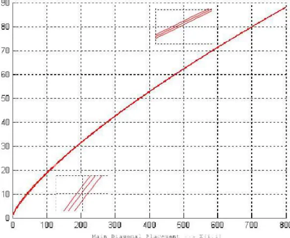
Fig. 3.1. Evolution off1, for F = 4 and d= 3. Insets show zooming the function in
specific domains.
Robustness fitness function f1
Watermark Robustness refers to the ability to recover the watermark image even after the watermarked image has been manipulated. We focus in obtaining ro-bustness against lossy compression and smoothing of the watermarked image. Both transformations affect the high and preserve the low frequency image trans-form coefficients. Therefore the closer to the transtrans-form space origin the mark is located, the higher the robustness of the mark. As we are embedding the water-mark image DCT, we note also that most of the waterwater-mark image information will be in its low frequency coefficients so.Therefore, they must have priority to be embedded in the positions that are nearer to the low frequencies ofXt. All these requirements are expressed in equations (3.1) and (3.2). Our robustness fitness function is the sum extended to all the watermark pixels of theα-root of the position norm.
f1=
mw
k=i nw
l=1
α
x(k, l)2+y(k, l)2+k+l (3.1)
α=F
x(k, l)2+k+
y(k, l)2+l
x(k, l) +y(k, l) +k+l +d (3.2) Equation (3.1) is based on the Euclidean distance of the position where a mark DCT coefficientWt(k, l) is placed to the DCT transformXtdomain origin :
x(k, l)2+y(k, l)2. The termsk+linside the root expression model the priority
of the watermark image DCT low frequency coefficients to be placed on robust placements. However, this distance has an unsuitable behavior to be taken as a fitness function for minimization. Its value decreases very fast when the pixel of the mark is placed near theXtlow frequencies, but remains almost constant when the mark is placed in the low-medium frequencies. This problem is known as the big plateau problem. To avoid this problem, we try to define a fitness function which shows smooth (bounded) but non-negligible variation over all the domain of solutions. To this end we introduce theα-root, with the root exponent being controlled by equation (3.2). The higher value of the root exponent, the closer to a constant value is obtained (although the function continues to have an exponential behavior). The more important the watermark DCT coefficient, the bigger the root exponent and the lower the fitness function. Equation (3.2) is a line function on the following ratio
α=
x(k, l)2+ y(k, l)2
x(k, l) +y(k, l)
which takes values between zero and one. This ratio is modulated by a factor F and a displacementd. As said before, the fitness function has to be sensible to the relative importance ofk, lin the watermark image DCTWt(k, l) domain. Equation (3.2) also introduces this sensitivity by taking into account the k, l coordinates.
Figure 3.1 shows the behavior of f1 when three different pixels of Wt are embedded in the main diagonal of Xt. The x axis of this plot represent the position in the main diagonal. The function grows smoothly and steadily without plateau effects towards the high frequency region. The insets show that the behavior of the function depends also of the watermark image DCT coefficient Wt(k, l) placed (bigger the lower frequencies).
The robustness fitness does not depend on the band number, because each band DCT has been computed independently. In summary, this function pos-sesses the following properties:
1. As the position inXtwhereS(k, l) is embedded is closer to the low frequency region, the function value decreases smoothly.
2. As the pixel ofWt is more important (nearest to theWt low frequencies), the value ofαincreases smoothly, so the fitness function decreases smoothly. Thus,f1 must be minimized to maximize the robustness.
Distortion fitness functionf2
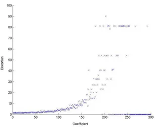
Fig. 3.2. Plot of distortion of the watermarked image versus coefficient magnitude regardless of position
Fig. 3.3.Illustration of the Crossover Operator based on 2 cut points
the transform domain. Thus, the distortion fitness function to be minimized we propose is the following one:
f2=
mw
k=i nw
l=1
|Xt(x(k, l), y(k, l), z(k, l))| (3.3)
3.5.2 Evolutionary Operators
Selection Operator:This operator generatesO fromP. The populations has
previously been ordered according to its range and distance between solutions as proposed in [7]. The selection is realized by random selection of the individuals, giving more probability to the ones at the beginning of the sorted list.
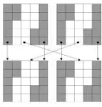
Crossover operator:This operator is applied with probabilityPc and is used
to recombine each couple of individuals and obtain a new one. Two points from the solution matrix are randomly selected as cut points, and the individuals are recombined as in conventional crossing operators. This operator is illustrated in 3.3.
Mutation operator: Every element of an individual solution s undergoes a
mutation with probabilityPm. The mutation of an element consists of displacing it to a position belonging to its 24-Neighborhood in the 3D DCT domain grid: given a pixelWt(k, l) located in the positionx(k, l), y(k, l), z(k, l) ofXt, the new placement ofs(k, l)∈ {Xt(x(k, l)±1, y(k, l)±1, z(k, l)±1)}. The direction of the displacement is randomly chosen. If the selected position is out of the image, or collides with another assignment, a new direction is chosen.
Reduction operator: After applying the selection, crossover and mutation
3.5.3 Algorithm
The first step of the GA is the generation of an initial population P and the evaluation of each individual’s fitness. The rank and distance of each individual is calculated [7] and is computed to sortP. Once done this, the genetic itera-tion begins: An offspring populaitera-tionO is calculated by means of the selection, crossover, and mutation operators. The new individuals are evaluated before joining them to the populationP. Finally, after computing the reduction opera-tor over the new rank and distance of each individual, we obtain the population P for the next iteration.
Since the GA works with many non-dominated solutions, the stopping cri-terion compares the actual population with the best generation, individual to individual, by means of the crowded comparison() [7]. If no individual, or a number of individuals below a threshold, improves the best solution inn con-secutive iterations, the process is finished. A pseudo-code for de GA is shown in figure 3.4.
Pob = Generate_Initial_Population(); Fitness_Function_Evaluation(Pob); Range=fast_non_dominated_sort(Pob);
Distance=crowding_distance_assignment(Pob); Stop = false;
While Stop == false
Couples = Selection_Operator(Pob); Of = Merge_Operator(Couples); Of = Mutation_Operator(Of); Fitness_Function_Evaluation(Of); Pob = Join(Pob,Of);
Range = fast_non_dominated_sort(Pob);
Distance = crowding_distance_assignment(Pob); Pob = ordering(Pob, Range, Distance);
Pob = Reduction_Operator(Pob); Evaluate_Stop_Criterium(): end while;
plot(Pareto-Front);
Fig. 3.4.Pseudo-code for the proposed GA
The Pareto front is formed by the set of solutions with rank = 1. Once finished the process and chosen a solution, the mark is embedded adding its coefficients to the coefficients ofXtaccording to the corresponding value ofs∗. Before the coefficients are added, they are multiplied by a small value.
3.6
Results
Fig. 3.5.Pareto fronts found by GA and local search, identified by ‘x’ and ‘.’ respec-tively
Fig. 3.6.From left to right: Original Image; Images watermarked using the placement denoted in figure 3.5 as solution 3, as solution 2 and as solution 1
that proposed algorithm finds robust and low distortion watermark placements, therefore the proposed fitness functions can be assumed to model appropriately the desired watermark properties. Then we extend the results to a well known benchmark hyperspectral image.
3.6.1 Results on a Conventional Gray Level Image
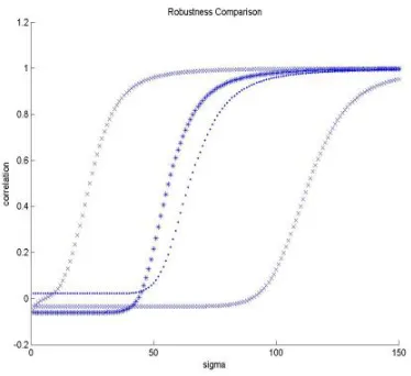
Fig. 3.7. Robustness measured as the correlation coefficient of the recovered image mark versus the radius of the gaussian smoothing filter. Each curve corresponds to a placement solution identified in in figure 3.5. Solutions 1 and 3 are represented by ‘x’. Solution 2 by ‘*’ and Solution 4 by ‘.’.
Fig. 3.8.Watermark logo: Original and recovered from the image watermarked using placement solution 2 in figure 3.5 after it has been low-pass filtered withsigma= 50, 60, 70, 80, 90, 100
overlapping and regular image blocks of size 100 x 100. The initial population is formed by 672 individuals each one placed randomly in a different quadrant. As the watermark image we have used an image of size 32 x 32. The GA was executed with Ps = 20, Pm= 0.05 andPc = 0.9. We set the robustness fitness f1 parameters toF = 4 andd= 3.
For comparison purposes the problem has been solved by means of a random local search starting from the same random initial conditions. This local search consist only of proposing a new placement by a random perturbation computed like the mutations above. This new placement is accepted if it does improve the current solution. The local search stops when a number of proposed placements are rejected, assuming that the algorithm is stuck in a local optimum. Figure 3.5 shows the Pareto-Front found with both algorithms. The GA has found 329 non-dominated solutions while the local search only found 62. Besides the GA solutions dominate all the solutions found by the local search.
Fig. 3.9.Robustness of watermark placement solutions 2 (‘.’) and 4 (‘+’) in in figure 3.5 to JPEG compression. Correlation of the recovered mark image versus compression quality.
distortion value, regardless of the robustness fitness value (which is very high). The solution signaled as 3 corresponds to the solution with lowest robustness fit-ness, regardless of the fitness distortion value (again very high). These solutions correspond to optima of the objective criteria taken in isolation. We consider also compromise solutions 2 and 4 that correspond to the best robustness for a set upper limit of the distortion, taken from the Pareto fronts found by the GA (solution 2) and the local search (solution 4). Figure 3.6 shows the experimental image (left) and the visual results of GA generated watermark placement solu-tion. The distortion is almost no perceptible, but for the image corresponding to solution 3 in figure 3.5.
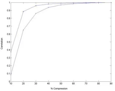
To asses the robustness of the watermark placements found, we compute the correlation coefficient between the original watermark and the watermark recov-ered from the watermarked image after it has been smoothed by a low-pass gaus-sian filter applied in the Fourier transform domain. The figure 3.7 plots the corre-lation coefficients versus the increasing filter radiussigmafor each of the selected watermark placement solutions selected in figure 3.5 . This plot shows that the watermark placement solution 2 obtains a good correlation coefficient for lower values ofsigmathan solution 1 (note that in figure 3.6 there are no perceptual dif-ferences between both images). That means that the GA found a solution that is much more robust than the one with minimal distortion while preserving much of the distortion quality. It can be appreciated also in figure 3.7 that the robustness is higher in the solution 2 (GA) than in the solution 4 (Local Search) . Figure 3.8 shows the visual results of the recuperation of the mark image after smoothing the image watermarked using the placement from solution 2.
image. Figure 3.9 shows the correlation of the recovered mark image relative to the original mark image versus compression quality, for the local search and GA watermark placement solutions identified as 4 and 2 in in figure 3.5 . It can be appreciated that the GA solution recovers much better than the local search solution from strong lossy compression.
3.6.2 Results on an Hyperspectral Image
The results presented in this section concern the application of the algorithm over the well known AVIRIS Indian Pines hyperspectral image of size 145 x 145 x 220. The image DCT transformXt has been divided in 1452 overlapping quadrants of size 45 x 45 x 110. The initial population is formed by 1452 individuals each one placed randomly in a different quadrant. The watermark is an image of size
(a) Pareto-Front (b) NonDominated Evolution
Fig. 3.10. a) Pareto front found by GA. b)Evolution of the number of non-dominated solution found by the GA.
(a) Filtering (b) Recovered watermark
50 x 50. The GA was executed with Ps = 20, Pm = 0.05 and Pc = 0.9. We fit the response of the robustness fitnessf1 withF = 4 andd= 3.
Figure 10(a) shows the Pareto front consisting of 303 non-dominated solu-tions, found by the algorithm, following the evolution shown in Figure 10(b). Figure 11(a) plots the correlation coefficient between the original watermark and the watermark recovered after each band image of the watermarked image has been smoothed by a low-pass gaussian filter with increasing filter radius ap-plied in the Fourier transform domain. Figure 11(b) shows the visual results of the recuperation of the mark image after smoothing the watermarked image.
Studying each pixel spectrum, experts can know which material form the area represented by this pixel. Automated classification systems can be constructed [11] to perform this task. This is the main objective of hyperspectral imaging, so, it is critical that the watermarking process doesn’t disturb the spectral content of the pixels. For the noisiest of the solutions shown in Figure 10(a) we computed the correlation of each pixel spectrum with the corresponding one in the original image. The worst value obtained was 0.999. Therefore, this watermarking process is not expected to influence further classification processes.
3.7
Conclusions
We present an evolutionary algorithm to find a watermark’s image placement in an hyperspectral image to protect it against undesirable manipulations. It is de-sirable that the watermark remains recognizable when the image is compressed or low-pass filtered. We state the problem as a multiobjective optimization prob-lem, having two fitness functions to be minimized. The algorithm tries to obtain the Pareto front to find the best trade-off between distortion of the original im-age in the embedding process and robustness of the mark. The solutions found by the GA provide strong robustness against smoothing manipulations of the image. Because the algorithm works with the entire image DCT, it can be used to hide bigger images or data chunks than other similar approaches. Also it will be more robust than approaches based on small block embedding, experimental verification is on the way to prove this intuition. Furher work must be addressed to the extension of this approach to wavelet transforms of the images.
References
1. Augot, D., Boucqueau, J.M., Delaigle, J.F., Fontaine, C., Goray, E.: Secure delivery of images over open networks. Proceedings of the IEEE 87(7), 1251–1266 (1999) 2. Back, T., Fogel, D.B., Michalewicz, T.: Evolutionary Computation1. Basic
Al-gorithms and Operators. Board Addison-Wesley Publishing Company, Reading (2000)
4. Barni, M., Magli, E., Troia, R.: Minimum-impact-on-classifier (mic) watermarking for protection of remote sensing imagery. In: IGARSS 2004, vol. 7, pp. 4436–4439 (2004)
5. Caldelli, R., Macaluso, G., Barni, M., Magli, E.: Joint near-lossless watermarking and compression for the authentication of remote sensing images. In: IGARSS 2004, vol. 1, p. 300 (2004)
6. Coello Coello, C.A., Toscano Pulido, G., Mezura Montes, E.: Current and future research trends in evolutionary multiobjective optimization. In: Gra˜na, M., Duro, R., d’Anjou, A., Wang, P.P. (eds.) Information Processing with Evolutionary Al-gorithms, pp. 213–232. Springer, New York (2004)
7. Deb, K., Pratap, A., Agarwal, S., Meyarivan, T.: A fast and elitist muliobjective genetic algorithm: Nsga-ii. IEEE transactions on evolutionary computation 6(2), 182–197 (2002)
8. Ho, A.T.S., Jun, S., Hie, T.S., Kot, A.C.: Digital image-in-image watermarking for copyright protection of satellite images using the fast hadamard transform. In: IGARSS 2002, vol. 6, pp. 3311–3313 (2002)
9. Kaarna, A., Parkkinen, J.: Multiwavelets in watermarking spectral images. In: IGARSS 2004, vol. 5, pp. 3225–3228 (2004)
10. Kaarna, A., Toivanen, P.: Digital watermarking of spectral images in pca/wavelet-transform domain. In: IGARSS 2003, vol. 6, pp. 3564–3567 (2003)
11. Landgrebe, D.A.: Signal Theory Methods in Multispectral Remote Sensing Signal Theory Methods in Multispectral Remote Sensing. Wiley-Interscience, Chichester (2003)
12. Maeno, K., Qibin, S., Shih-Fu, C., Suto, M.: New semi-fragile image authentica-tion watermarking techniques using random bias and nonuniform quantizaauthentica-tion. Multimedia, IEEE Transactions 8(1), 32–45 (2006)
13. Nikolaidis, A., Pitas, I.: Region-based image watermarking. IEEE Transactions on image processing 10(11), 1726–1740 (2001)
14. Qiming, Q., Wenjun, W., Sijin, C., Dezhi, C., Wei, F.: Research of digital semi-fragile watermarking of remote sensing image based on wavelet analysis. In: IGARSS 2004, vol. 4, pp. 2542–2545 (2004)
15. Schneck, P.B.: Persistent access control to prevent piracy of digital information. Proceedings of the IEEE 87(7), 1239–1250 (1999)
16. Young, K.T., Hyuk, C., Kiryung, L., Taejeong, K.: An asymmetric watermarking system with many embedding watermarks corresponding to one detection water-mark. Signal Processing Letters 11(3), 375–377 (2004)
17. Tamhankar, H., Bruce, L.M., Younan, N.: Watermarking of hyperspectral data. In: IGARSS 2003, vol. 6, pp. 3574–3576 (2003)
18. Tamhankar, H., Mathur, A., Bruce, L.M.: Effects of watermarking on feature effi-cacy in remotely sensed data. In: IGARSS 2004, vol. 1, p. 280 (2004)
19. Tang, X., Pearlman, W.A., Modestino, J.W.: Hyperspectral image compression using three-dimensional wavelet coding. In: Image and Video Communications and Processing 2003, Proceedings of SPIE, vol. 5022, pp. 1037–1047. SPIE Press (2003) 20. Vleeschouwer, C., Delaigle, J.F., Macq, B.: Invisibility and application function-alities on perceptual watermarking- an overview. Proceedings of the IEEE 90(1), 64–77 (2002)
22. Wolfgang, R.B., Podilchuk, C.I., Delp, E.J.: Perceptual watermarking for digital images and video. Proceedings of the IEEE 87(7), 1108–1126 (1999)
23. Yuan, H., Zhang, X.P.: Multiscale fragile watermarking based on the gaussian mixture model. Image Processing, IEEE Transactions 15(10), 3189–3200 (2006) 24. Zou, Y.Q., Shi, D., Ni, Z., Su, W.: A semi-fragile lossless digital watermarking
Architecture and Services for Computational
Intelligence in Remote Sensing
Sergio D’Elia1, Pier Giorgio Marchetti1, Yves Coene2, Steven Smolders3, Andrea Colapicchioni4, and Claudio Rosati4
1
The Earth is facing unprecedented climatic and environmental changes [1], which require a global monitoring [2] and large scale actions which are addressed by European and world wide programmes of similar wide scale. The overall objec-tive of a sustainable growth demands for a cleaner, safer and healthier global environment. The 7th Framework Programme (FP7) of the European Commis-sion (EC) assumes that the Information and Communication Technologies (ICT) may play a role in combating the unsustainable trends that risk undermining the future economic growth and impact on the quality of life in Europe:
• environmental degradation and unsustainable use of depleting natural re-sources;
• pollution and waste generation;
• increasing exposure and risk to man made and natural disasters.
Furthermore other initiatives are addressing other challenges which if unco-ordinated may undermine the objective of a single information space in Europe, which the EC has set as one of the targets for the so-called Lisbon Agenda (i2010):
• INSPIRE - infrastructure for spatial information in Europe. The INSPIRE directive addresses the European fragmentation of datasets and sources, gaps in availability, lack of harmonisation between datasets at different geographic scales and duplication of information collection. The initiative intends to trigger the creation of a European spatial information infrastructure that delivers to the users integrated spatial information services. These services should allow the policy makers, planners and managers at European, national and local level, the citizens and their organisations to identify and access spatial or geographical information from a wide range of sources.
• GMES Global Monitoring for Environment and Security is a joint EC -ESA programme with the objective to establish a European capacity for
global monitoring by 2008. Work is in progress on the development of pilot and fast track services (land, marine, emergency response), on multi-mission facilities and on the integration of national and European missions to guar-antee continuity of data and services, as well as on the development of the space component (the Sentinels missions) in order to ensure the necessary space data capacity by 2012.
• GEO / GEOSS - The Group of Earth Observations (GEO) is an organisation dedicated to developing and instituting a Global Earth Observation System of Systems (GEOSS).
These initiatives demand data from Earth Observation (EO) satellites, op-erating as single missions or constellations, which increase revisit time. Sensors on board of these satellites acquire data in increasing variety, amount and res-olution, resulting in huge amounts of data to be handled. On the other side, users, service industry and the above initiatives require timely delivery of focused information. Therefore EO satellites’ data, which are not immediately usable, require chained transformations before becoming the needed “information prod-uct” (easily understandable and ready-to-use without further manipulations) offered as on-demand or systematic services.
Different actors perform these transformations using own processes, which require specific knowledge, experience and possibly also data or information from domains other than EO. Today, a number of specialised companies, operating independently in specific application domains, tend or are forced to build and keep full control of the entire process, with efforts going beyond their core interest and expertise. This often results in an inefficient system, where parts of the processes are redeveloped many times without benefits for the end user (no competition increase) or the service provider (deploying resources on non-core activities).
Additional cost efficiency could come from the reduction of the information extraction time through the automation of such processes, by using systems which can learn and / or apply knowledge. Automatic or semi-automatic Image Information Mining (IIM or I2M) techniques would permit to quickly identify the relevant subset among the large quantity of images, as well as to support and integrate the expert’s interpretation. This approach would also permit to apply these processes to a bigger portion of the petabytes of archived or new data, which currently are systematically processed only in limited quantities.
The SOA approach is well suited to support the resulting “system of systems”. For example interoperability between the SOA approaches chosen by EC WIN, EC ORCHESTRA, and ESA SSE projects was recently demonstrated [4]. This chapter describes in detail the architecture of two ESA environments, instances of which may become components of this hierarchical “system of systems” for GMES and GEO. They are in the field of Service Provisioning Support and Image Information Mining. A view on the selected underlying architecture precedes the descriptions of these two environments. The descriptions are provided according to two different methodologies, an engineering one and a user / history focused one.
4.1.2 Service Oriented Architectures
The benefits of the proposed Service Oriented Architecture are;
• Loosely-coupling and independence
– Increases organisational agility; allows service providers to easily design, assemble, and modify business processes in response to market require-ments;
– Provides a competitive advantage by offering greater flexibility in the way computer systems can be used to support the business;
– Reduces time to market, fostering re-use of available services; – Lowers implementation costs by increasing reusability; • Independence
– Increases IT adaptability; changes of the IT technology and evolution of standards, are easily integrated;
– Improves service providers’ response to sector evolution as changes in organisations and processes are easily accommodated.
• Modularity
– Enables incremental development, deployment, and maintenance, reduc-ing the need for large “one shot” software developments;
– Decreases development effort and time by reducing complexity; – Reduces the total number of processes;
– Fosters and facilitates the deployment of new services as the service or-chestration supports the streamlining of processes and the assembly of existing services into new more complex ones.
• Neutrality
– Allows legacy services and existing investment in IT assets to be lever-aged.
• Resilience
– Lowers risk and development effort; minimising the need to rewrite and test existing applications and services.
• Standards-based
– Allows economies of scale as the same technology can be applied to sup-port and deliver a wide range of services;
– Reduces complexity and fragmentation resulting from use of proprietary technologies.
4.2
SSE: Service Support Environment for Earth
Observation and Other Domains
4.2.1 Motivation and User Requirements
The ESA Service Support Environment (SSE) implements a neutrally managed, open, service-oriented and distributed environment that enables the orchestra-tion and integraorchestra-tion of EO, meteorological and geospatial data and services.
The three high level requirements that this infrastructure fulfils are:
• Simplify the access to multiple sources of EO data. • Facilitate the extraction of information from EO data.
• Reduce the barrier for the definition and prototyping of EO Services. Users of EO data require accessing multiple data sources from different providers. The analysis of the value-adding services has revealed that more than 60% of the efforts involved in the creation of such services are devoted to access-ing the EO data.
The European Space Agency’s Oxygen project [5] indicated that EO Services, whether commercial or public, are about the provision of the right information at the right moment to the proper user. The need to define the interoperability standards to ease the EO data access in Europe is as well a priority. In fact, during the initial phase of the joint ESA and EC GMES programme, the Agency shall provide harmonised access to ESA, national, EUMETSAT and other third party Earth Observation Missions for the so-called GMES Fast Track Services, and therefore provide the required capacity to satisfy the GMES space-based observation needs. In order to deliver the high-level operational services which are needed, it is necessary to integrate EO products, space data, with all kinds of other data and information.
The complexity of this next generation of integrated services may also require establishing:
• a distributed digital library of geospatial services, as well as,
• a network of centres able to support the partners who will contribute to the production and delivery of data access and information services.
4.2.2 The Methodology for Architecture Design
The proposed Service Oriented Architecture is designed and described making use of the RMODP model (Reference Model of Open Distributed Processing -RM-ODP - SO/IEC 10746-1:1998) [6]. The -RM-ODP model has been modified to take into account the objective of addressing a digital library of distributed services rather than a distributed processing system for which the RM-ODP was originally defined.
The RM-ODP model analyses open distributed systems through 5 different views of the system and its environment:
• The enterprise viewpoint: focuses on the purpose, scope and policies for the system.
• The information viewpoint: focuses on the semantics of the information and information processing performed.
• The computational viewpoint: enables distribution through functional de-composition of the system into objects which interact at interfaces.
• The engineering viewpoint: focuses on the mechanisms and functions required to support distributed interaction between objects in the system.
• The technology viewpoint: focuses on the choice of technology in that system.
In the design of the proposed architecture, the RM-ODP was tailored by replacing the computational viewpoint with a service viewpoint as detailed in the following paragraphs.
4.2.3 Enterprise Viewpoint
The enterprise viewpoint is concerned with the business activities of the Service Support Environment. These activities can be represented by two sets of use cases related to respectively the end-user of services and the service provider (or service owner).
• End-users benefit from this environment as it brings together distributed EO services and EO products offered by multiple service providers. Via this com-mon access point (accessible from the Web Portal or from a service registry or catalogue), the end-user can more easily discover services and products matching his exact requirements. EO product, collection and service cata-logues for multiple missions of different satellite operators are offered within a single environment and are linked with data access, programming (planning of sensors’ acquisitions), ordering and processing services hereby offering a one-stop solution for users of EO data and services.
other services that may possibly be provided by third parties hereby facil-itating the definition of advanced value-adding services on EO imagery by distributing the processing steps over different specialists. Service providers can offer these services via the Portal pages or via a machine-to-machine “data access integration layer” allowing discovery of their services via a vir-tual service and data registry or catalogue.
The enterprise viewpoint thus addresses following high level objectives:
• provide a neutrally managed overarching infrastructure enabling the interac-tions among service providers and with end-users;
• permit service interaction whilst avoiding the service de-localisation (i.e. ser-vices remain on the service provider infrastructure);
• allow easy publishing and orchestration (i.e.: chaining of services into more complex ones) of synchronous and asynchronous EO services for online and offline processes;
• support “subscription” type services and standing orders (e.g. fires active monitoring and alerting);
• support the evolution and maintenance of services;
• allow easy identification of, and access to requested services and products, with progress follow-up until completion;
• integrate services from multiple domains, e.g. geospatial, meteorological, in-situ, to exploit multi-domain synergies;
• minimise service provider investments by building on open standards.
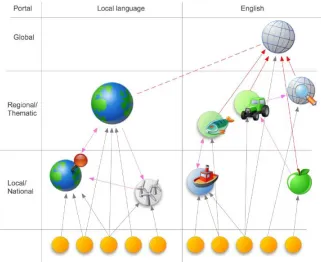
As the objective is to define an environment capable of supporting multiple sce-narios, we envisage implementing a scalable digital library environment. This will allow the services to be deployed at different scales as depicted in the figure 4.1: global (e.g. European or worldwide), national, regional or thematic and local.
The Service Support Environment aims at providing a consistent experience within which the user will be able to discover and access a variety of services offered by numerous disparate providers. At the same time the content and behaviour of these services should be predictable allowing the user to anticipate the results and use the services through a normal Internet connection. This idealised approach is represented in figure 4.2 as an “Internet bus” approach [7].
4.2.4 Information Viewpoint
The information viewpoint specifies the modelling of all categories of informa-tion that the proposed architecture deals with, including their thematic and spatio-temporal characteristics as well as their metadata. Within ESA’s SSE in-frastructure, these information models are based upon Open Standards where these are available.
Service Metadata Information Model
Fig. 4.1.Distributed Service Support
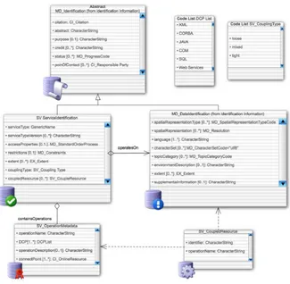
metadata of these services. This service metadata needs to provide the details to allow for machine-to-machine communications but also contain descriptive information targeted at human readers. This service metadata can be modelled according to ISO 19119 [8], as shown in figure 4.3. Each service may be defined by:
• Identifying properties of the service itself: the type of the service, its title and abstract, its usage restrictions, its region/time period of applicability; • Identifying information of the service owner: the point of contact;
• The service operations (e.g. GetCapabilities, GetMap, GetFeasibility, Sub-mitOrder, ...) with their connection points and protocol bindings;
• The parameters associated with these operations and dependencies and chains of operations.
Fig. 4.2.Internet Bus Approach
so-called loosely coupled services that are not associated with specific datasets or dataset collections. Services that are mixed coupled are associated with a specific dataset or dataset collection but can also operate on other datasets as for instance a Web Coordinate Transformation Service that may work on EO Products from specific collections but may also work on other images. The cou-pling between the service and dataset(s) collections is done via an “OperatesOn” association. In addition individual service operations can be tied to the datasets by providing the “CoupledResource” Information.
For the discovery of EO related services, a minimal recommended subset of this ISO 19119 information model required for the discovery of services has been defined. This subset includes all mandatory ISO 19119 items and makes a number of optional elements mandatory. The optional operation parameters, dependen-cies and operation chain related elements are not included in this minimal set that is visualised within the figure 4.3.
This ISO 19119 standard defines the model for geographic services’ metadata; it however does not specify the exact XML grammar to be employed. This is dealt with in the draft ISO 19139 standard [9] that describes the transformation of the abstract UML models into XML schema.
EO Collection Metadata Model
Fig. 4.3. ISO 19119 Service metadata
Earth Observation context, a collection typically corresponds to the series of datasets (i.e. products) derived from data acquired by a single sensor onboard a satellite or series of satellites and having the same mode of operation. Exam-ples of EO collections are for instance “TerraSAR-X spotlight mode” or “ESA ENVISAT MERIS Full Resolution L1+2”.
elements, there are a number of elements that are optional but that may be made mandatory within an application profile.
As for the services information model, this ISO 191115 standard does not specify the exact XML encoding of metadata documents, this is dealt with in the ISO 19139 standard that was referenced above.
EO Product Metadata Model
The most important information model in the EO-related Service Support Envi-ronment is the EO product metadata which has been based on the Open GeoSpa-tial Consortium - OGC Geography Mark-Up Language - GML [11]. GML is a modelling language and XML encoding for the transport and storage of geo-graphic information, including both the geometry and properties of geogeo-graphic features. The specification defines the mechanisms and syntax that are used to encode geographic information in XML and constitutes an interchange format for geographical features. A feature is an abstraction of a real world phenomenon; it is a geographic feature if it is associated with a location relative to the Earth. More than a mere data format, GML can be considered as a set of building blocks for constructing a data model for geographic features within a specific application domain. By deriving from the base GML standard, it is possible to specify, in a so-called application schema, the structure and properties that are used to characterise specific features that are of relevance within the particular domain.
GML also defines a specific type of features called Observations. “A GML observation” models the act of observing, often with a camera, a person or some form of instrument. An observation feature describes the “metadata” associated with an information capture event, together with a value for the result of the observation. This covers a broad range of cases, from a tourist photo (not the photo but the act of taking the photo), to images acquired by space borne sensors. Next to the properties that are inherited from the base gml feature element, an observation is characterised by a mandatory time and result and optional properties that reference the sensor or instrument and the target of the observation. Obviously, these base properties are not sufficient to model the EO product metadata.
Fig. 4.4.Gmd schema layer
These sensor specific schemas: OHR for optical (high resolution), SAR for (syn-thetic aperture) radar and ATM for atmospheric products are shown near the top of the figure 4.4.
Other Information Models
Semantic Web Technology: Thematic instances of the SSE, e.g. an SSE dedicated to marine-related services, may also use emerging Semantic Web technology to facilitate the modelling and interlinking of information. It is envisaged to use W3C Resource Description Framework RDF and Web Ontology Language -OWL to enable end-users to more easily identify and locate services related to their domain, e.g. algae bloom, oil spill etc. by interlinking the services with agreed ontologies and controlled domain vocabularies or thesauri. The ESA KEO [13] project and the European Commission projects InterRisk [14] and WIN [15] are working on such marine-related ontologies.
entities that take one or more inputs and through the application of well-defined methods using specific parameters, result in one or more outputs. It also sup-ports linking between processes and thus supsup-ports the concept of process chains, which are themselves defined as processes. The use of SensorML is currently being evaluated.
4.2.5 Service Viewpoint
The computational viewpoint in the RM-ODP is replaced within the proposed architecture by the service viewpoint: It specifies the services that support the syntactical and semantic interoperability between the services, including the high-level operational services required by the GMES programme. Service ori-ented architectures like the one proposed shall place no restrictions on the gran-ularity of a (Web) service that can be integrated. The grain size can range from small (for example a component that must be combined with others to create a complete business process) to large (for example an application). It is envisaged to support two main categories of services:
• Basic services are limited services running on the service providers’ local infrastructure. Basic services may be requested (ordered) via the Portal’s user interface, or from within a composite service (or workflow).
• Composite services are services consisting of a combination of basic services or other composite services. A service provider using the graphical workflow definition tools provided by SSE can model composite services. Composite services can comprise services provided by different service providers.
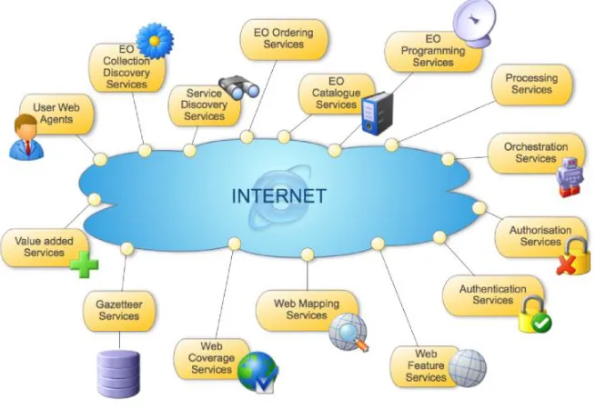
Another way of dividing services into categories relates to the specific func-tions performed by the service. The following set of specific EO data access services has been defined to specifically support the GMES Programme:
• Collection and service discovery; • Catalogue Service;
• Product Programming and Order; • Online Data Access;
• Satellite Multicast Service; • Identity (user) management; • Service Orchestration; • Processing Services.
This Service Viewpoint defines these different services from a functional point of view. The interfaces with which all of these services are implemented form the subject of the Technology Viewpoint that is described below.
Collection and Service Discovery
on these dataset collections, e.g. catalogue, ordering, data access or programming services.
Catalogue Service
The catalogue service allows a user to find datasets or products within a discov-ered dataset collection that meet specific search criteria such as time, geographic extent, cloud cover, snow cover, polarisation etc. and gives access to all dataset metadata available in a catalogue. As explained within the information view-point, these product metadata vary depending on the type of mission: optical, radar or atmospheric.
Product Programming and Order
A user accesses the ordering service to order datasets referenced from within the (distributed) catalogue service. He can also order future products, not yet in the catalogue by using the programming service.
Online Data Access
Various on-line data access services provide access to ordered datasets via the In-ternet. Such services typically use the File Transfer Protocol (FTP) for allowing access to EO data, but also more advanced methods such as OGC Web Services for data delivery and visualisation are supported by the SSE architecture:
• Web Coverage Services (WCS) for access to EO datasets,
• Web Feature Services (WFS) for access to features information derived from EO imagery (e.g. land cover classification),
• Web Map Services (WMS) for visualisation and evaluation purposes.
In the future, WCS access to satellite imagery may be combined with JPEG2000 compression technology and emerging Geo Digital Rights Manage-ment (GeoDRM) approaches.
Satellite Multicast Service
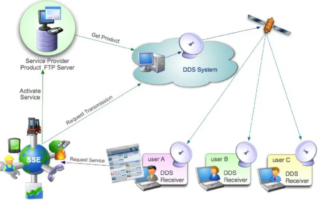
The ESA Data Dissemination System (DDS) complements the in-orbit inter-satellite link between ENVISAT and Artemis as shown in figure 4.5. This inter-satellite multicast service is used for data circulation and transfer within the ESA Ground Segment. Its spare capacity may be used by the SSE, as shown in figure 4.6, to multicast SSE service results to end-users having limited terrestrial Internet capacity using Eutelsat’s Ku band in Europe and C-band in Africa.
Identity (user) management
The current SSE supports access by the following types of users:
Fig. 4.5.Artemis satellite relaying ENVISAT data to ground
Fig. 4.6.DDS use via SSE
• Registered users can activate services for which the service provider has not restricted the access.
execution of these services via a console. A service provider can also specify his service to be access-restricted and thereby only allow specific registered users to access his service.
• The Administrator performs the administration of the system and can assign service provider rights to a user.
The next version of the SSE will allow for a single sign-on to the SSE by users registered in the various EO ground segments by providing a federated identity across participating ground segments. It will also support explicit definition of service access policies to the published Web services. A prototype of this is being prepared, which will rely on the OASIS Security Assertion Markup Language -SAML [18], OASIS ws-security [19] and possibly also the W3C ws-policy [20] specification. Internally, the user profiles will be stored in an LDAP registry.
Service Orchestration
Service orchestration, based on the OASIS Business Process Execution Language - BPEL [21], allows for composition of Web services, typically from multiple service providers or ground segments which themselves become then available as Web services. The orchestration engine is the service used to execute the resulting composite services. The resulting workflows can also contain interactive steps, e.g. to model a service provider’s internal authorisation processes.
Processing Services
Extensive tests have been performed within the ESA Grid infrastructure leading to a preliminary definition of a Grid-based Processing Service. This with the objective of reducing the burden caused by the transfer of large EO coverages by transferring instead the processing algorithms on the Grid that hosts within its storage element the coverages to be processed.
The OGC Web Coordinate Transformation Service (WCTS) is another pro-cessing service that was experimented with, in combination with a Spot Image Web Coverage Service as described in the OGC OWS-3 Imagery Workflow Ex-periments [22] and OWS-4 EO Sensor Planning Service exEx-periments [23].
A set of simple data manipulation services that perform generalisation, repro-jection, format conversion and clipping on both EO imagery and vector datasets that may be derived from these are integrated as horizontal services into the SSE. These form basic services that are available to other service providers to allow product delivery that exactly meets the end users’ format requirements.
4.2.6 Engineering Viewpoint