ScienceDirect
Procedia - Social and Behavioral Sciences 00 (2016) 000–000
www.elsevier.com/locate/procedia
1877-0428 © 2016 The Authors. Published by Elsevier Ltd.
Peer-review under responsibility of the organizing committee of CITIES 2015.
CITIES 2016 International Conference, Coastal Planning for Sustainable Marine Development,
CITIES 2016, 18
thOctober 2016, Surabaya, Indonesia
Green Infrastructure Concept for JABODETABEKJUR
Metropolitan Area
Gunawan Tanuwidjaja
a*, Tammy Lithania
b, Hendra Agustin Sugiarto
b, Andre Oktavino
Cipta
ba Architecture Program Study, Petra Christian University, Jl, Siwalankerto 121-131, Surabaya, Indonesia
b Student of Architecture Program Study, Petra Christian University, Jl, Siwalankerto 121-131, Surabaya, Indonesia
Abstract
Sixty “Mega Cities” would emerge by 2015 catering of 600 million populations, and were threatened by the climate change, because of cyclones, flooding, etc. Jakarta became a metro region covering Jakarta, Bogor, Tangerang, Bekasi, Depok and Cianjur. Jakarta metropolitan faced the very high population growth, urban sprawling, traffic jams, flooding, green open space reduction, environmental degradation, urban slums and illegal street hawkers. Flooding and traffic congestions were the two most important issues to solve.
SWOT analysis and urban design solutions were produced to create a sustainable solution. Related to transportation issues, Singapore Mass Rapid Transport (MRT) concept was evaluated. Meanwhile the Netherlands’ polder concept as well as Singapore’s Integrated Water Management were also analyzed.
The development of above ground MRT as well as Busway could be developed to connect Jakarta Metropolitan Region. The networks were developed on the main toll road networks. The MRT and Busway would eventually replace the need of automobile use in the future. The Transit – Oriented - Development (TOD) with high density can be suggested to be concentrated nearby the MRT and Busway interchange stations. The Netherlands’ polder and were adopted for urban’ low-lying lands in Jakarta Metropolitan Region, A polder system was defined as the Integrated Man-made Drainage System consisting Dikes, Drains, Retention Ponds, Outfall Structures or Pumping Stations. The polder system was proposed to be extended to Tangerang and Bekasi area.
* Corresponding author. Tel.: +62-81221220842.
© 2016 The Authors. Published by Elsevier Ltd.
Peer-review under responsibility of the organizing committee of CITIES 2015.
Keywords: Transportation, MRT, Busway, Flood prevention, Polder, Metropolitan City
1.Introduction
The world’s population increased exponentially from 2.521 billion to 6.782 billion from 1950 to 2009. Furthermore, it was predicted that the population could reach 9 billion by 2040.1The urbanisations rate also had
increased the urban population from 30% in 1950 to 50% in 2007 from total population. The World’s urban population was predicted to reach 60% in 2030. The unsustainable development phenomena, such as exponential urban population growth, rapid urbanisation, limited urban planning, less stringent development control, and land speculation, further caused urban sprawling in the “Mega Waterfront Cities.” The Mega Cities with more than 5 million populations each city. Sixty “Mega Cities” would emerge by 2015 catering of 600 million populations, i.e. Singapore, Hong Kong, Jakarta, Mumbai, Bangkok and Manila (Schultz, 2006).2
The Climate Change made the “Mega Cities” more vulnerable to cyclones, high winds, flooding, coastal erosion and deposition, and sea-level rise (Nicholls 1995, Rosenzweig & Solecki 2001).3 And combination of climate change
and other aspects would cause the urban lowlands more susceptible to floods and tidal waves.
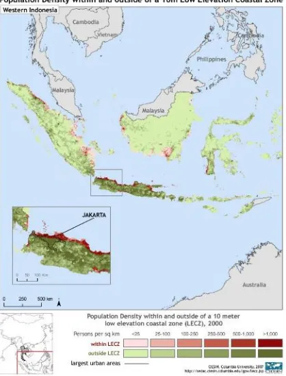
Figure 1 Locations of Mega Cities in the Coastal Areas of Indonesia. Sources: CIESIN, Columbia University, 2007 http://sedac.ciesin.columbia.edu/gpw/lecz.jsp. 4
Jakarta as one of the Mega Waterfront Cities was developed unsustainably (Goldblum & Wong 2000). 5The growth
"prime lands" has been converted into Office, Retail and Shopping Complex. It was recognized that poor management and coordination of the implementation of ineffective planning led to poor quality of urban planning. And the Jakarta Development Model City was illustrated by Ford (1993). 6
Jakarta has evolved becoming a metro region covering Jakarta, Bogor, Tangerang, Bekasi, Depok, Puncak and Cianjur. The Jakarta Metro Region was referred as Jabodetabekpunjur region and formed based on Government Regulation (PP) No.26 Year 2008. This area also was identified as National Strategic Area (Kawasan Strategis
Nasional) in the Indonesian National Spatial Plan (Rencana Tata Ruang Wilayah Nasional) due to the economic
potential. And due to that Central Government should integrate the mega city development. In the Jakarta metro region, a gap between elite – planned - housings and unplanned - urban - village (kampung kota) existed. Jakarta metropolitan city faced similar issues of very high population growth, urban sprawling, traffic jams, flooding, green open space reduction, environmental degradation, urban slums and illegal street hawkers (Dardak & Poerwo, 2007).
7
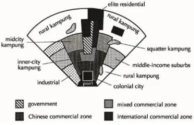
Figure 2 A Model City in Indonesia, like Jakarta Metropolitan City described by Ford (1993). 8
Figure 3 Development of Urbanization in the region Jabodetabekjur of the year 1972-2005, The red areas showed the urbanisation areas.
Source: (Dardak & Poerwo, 2007). 9
Figure 4 Urban Migration in Jabodetabekjur that showing Urban Sprawling. Source: Sutanudjaja & Arifin, (2011). 10
congestions were found and wasting of Rp. 10 Billion per year fuel cost and Rp. 17.2 Billion vehicle operation cost per year (the city government (Sutanudjaja & Arifin, 2011). 11
Floods were the regular disasters for Jakarta City. In 1619, Jakarta or previously named Batavia was developed by Jan Pieters Z. Coen with waterfront city concept or urban polder concept following the city of Amsterdam. But unfortunately, Jakarta was inundated by major floods in 1621, 1654, and 1918. Further, major inundations recorded happened in 1976, 1997, 2002, and 2007. 12
The 1997’s Jakarta floods occurred city-wide and created the national tragedy which attracting public even worldwide attentions. The flood covered the area of 4 sub-districts (Kelurahan), 745 houses, displacing 2640 persons with 80 cm water level. Further, the Jakarta flood got worse in 2002 affecting 60% of Jakarta. It also impacted Tangerang and Bekasi area. It was reported killing 142 persons and displacing 114,441 persons. Further, Rp 4 trillions economic losses were estimated caused by the flood. 13
In 2007, Jakarta flood affected more than 60% of Jakarta. It also affected Bogor, Depok, Tangerang and Bekasi. 80 persons were reported killed, while 340,000 persons had been displaced. Furthermore, 74,000 houses were submerged; 670,000 people lived without electricity; and 82.150 sq km of roads were damaged. Further The Director of Urban, Spatial Planning and Land Issues of National Planning Board of Indonesia (BAPPENAS), Mr. Luky Eko Wuryanto, estimated that Rp 8 trillions economic losses were caused by the floods. The breakdown were: Rp 1,7 trillions of housings damage; Rp 600 billions of infrastructures damage; Rp 2 trillions of Industrial, Financial and Small Medium Enterprises (SMEs) sector losses; Rp 4,8 billions of institutions buildings damage; and Rp 3,6 billions other losses. This data actually illustrates the worsening floods in Jakarta, and increasing economic losses due to the flooding. 14
In general, Jakarta floods are caused of two groups of factors, which are: natural factors and human factors. They are: 15
1. Natural Factors
• Approximately, 40% of Jakarta areas are low-lying land below the highest astronomical tide. • Flat topography of Jakarta (even concave in some area sop potential for flooding).
• 40% of Jakarta are located within the flood prone areas of the main rivers. • High rain intensity in the upstream of Jakarta Metro Region.
• Extensive catchment affecting Jakarta (850 sq km).
• Limited water bodies capacity (drains, rivers, retention ponds and lakes).
• Geological and soil types of the Jakarta Metro Region are susceptible to land subsidence and erosion.
2. Human Factors
• Disintegration of Spatial Plan and Drainage Master Plan (macro and micro level) of Jakarta Metro Region. • Overpopulation in several areas (strategic areas and slums).
• Extreme groundwater extraction.
• Conversion of forests, wet agricultural lands
• Conversion of water bodies (wetlands, agricultural lands, drains, rivers, retention ponds, lakes). • Unsustainable land development practice causing increasing soil sedimentation.
• Solid waste and waste-water pollution in the water bodies.
• The unclear system role-sharing among in environmental management especially in the drainage management.
Jakarta Spatial Plan (RTRW) of 2030 recommended several solutions such as (Planning Agency of Jakarta Special Province/ BAPPEDA DKI Jakarta, 2009) : 16
• Need of facilities and infrastructure provision such as: clean water, liquid and solid waste, telecommunications,
energy
• Limited public funding
Because of similar finding by Jakarta Planning Agency, we proposed a conceptual infrastructure framework for sustainable development in Jakarta Metropolitan Region.
2.Methodes
The research was conducted with SWOT analysis and urban design solutions. To create a sustainable solution, a literature review on Singapore as well as other cities were conducted. And the solution was discussed with the architects and proposed to the Jakarta’s Metropolitan Urban Design Competition. The paper also proposed to disseminate the concept again.
3.Result and Discussions
For transportation issues, Singapore Mass Rapid Transport (MRT) concept was evaluated. Meanwhile the Netherlands’ polder concept as well as Singapore’s Integrated Water Management were also analysed for further implementation.
The MRT system in Singapore could answer the need of urban sprawling of the Jakarta Metropolitan Region. The Urban Redevelopment Authority (URA) proposed Master Plan Singapore-based mass transportation system MRT (Mass Rail Transit) in 1970-1980 and the integrated planning of the Housing Development Town board (HDB Town) which is a high density in various Locations in Singapore. (http://www.ura.gov.sg).17
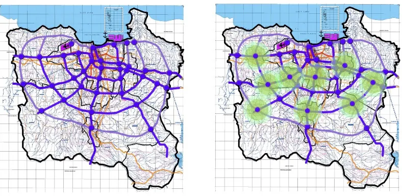
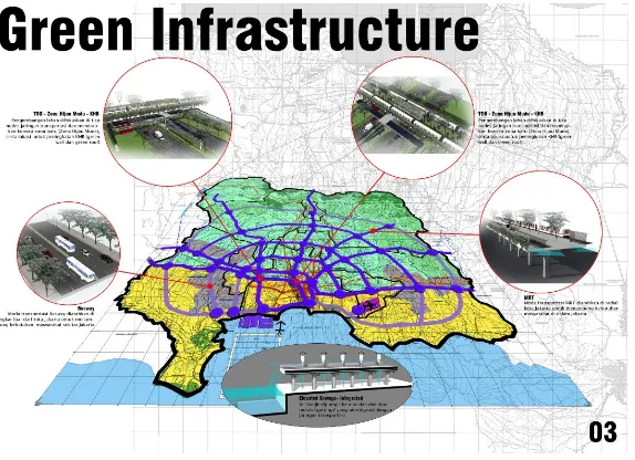
The development of above ground MRT as well as Busway could be developed to connect Jakarta Metropolitan Region. The networks were developed on the main toll road networks. The existing connectivity should be expanded to the suburban of Jakarta Metropolitan. The MRT and Busway would eventually replace the need of automobile use in the future. The Transit – Oriented - Development (TOD) with high density can be suggested to be concentrated nearby the MRT and Busway interchange stations. Additional drive - and - park structures could be proposed in several areas of the urban fringe to reduce the traffic to the city.
Figure 6 Above - the - Ground – MRT line developed on top of toll road
Figure 7 Busway line developed on top of the toll road
Figure 9 The MRT and Busway interchange station
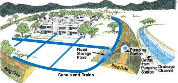
The Netherlands’ Polder was also adopted for urban’ low-lying lands in Jakarta Metropolitan Region, A polder system was defined as “An Integrated Man-made Drainage System consisting Dikes, Drains, Retention Ponds, Outfall Structures and Pumping Stations. Designed Landscape in the Polder is required to ensure its effectiveness. Polder Dikes should be planned and designed considering potential of soil strength, land subsidence, social conflict as well as accessibility issue. The maintenance of infrastructures becomes a critical point for successful polder operation. Lastly, the Polder system must be planned in integration from macro spatial plan, urban design and water management of the macro (river basin) system.”
Figure 10 Illustration of Polder System. Sources: Ministry of Public Works et.all. Urban Polder Guideline18
Because of the current polder system was not integrated, the polder system should be evaluated and expanded to Tangerang and Bekasi area. The polder system should be integrated with the current connectivity. And some roads could be utilised for drainages and dikes.
Figure 11 The Polder System on the Northern Area of Jakarta Metropolitan Region (sympbolised in the yellow area)
4. Conclusions
Jakarta metropolitan city faced three main issues of urban sprawling, traffic jams, flooding. The issue of flooding and traffic were two important issues to discuss. The development of above - ground - MRT and Busway networks could be developed to serve the Region. The networks were developed on the main toll road networks. The existing connectivity should be expanded to the suburban of Jakarta Metropolitan.
Meanwhile Polder system should be adopted for urban’ low-lying lands in Jakarta Metropolitan Region. The new polder system should be expanded to Tangerang and Bekasi area with integration to the Metropolitan Drainage System. These systems could become the green infrastructure of the Greener Jakarta Metropolitan area.
Acknowledgements
We thank all parties contributed to this concept
• Petra Christian University; Mrs. Eunike Kristi Julistiono, ST, M.Des.Sc., Prof. Ir. Lilianny Sigit Arifin, M.Sc.,Ph.D.and Ir. Benny Poerbantanoe, MSP.
• Dr. Ir. I.F. Poernomosidhi Poerwo, M.Sc, MCIT. MIHT;
• Ir. Joyce Martha Widjaya MT. Research Institute of Policy and Technology Implementation (Pusat Penelitian dan Pengembangan Kebijakan dan Penerapan Teknologi).
• SETARA Studio Team; Hermawan Dasmanto ST., Goya Tamara Kolondam ST., Erel Hadimuljono ST., Clifford Sutedjo ST., Martha ST.
• The Netherlands Ministries of Transport, Public Works and Water Management, and of Spatial Planning, Housing and Environment: Prof. Bart Schultz, PhD, MSc, and Mr. Martijn Elzinga.;
• UNESCO-IHE: F.X. Suryadi PhD, MSc;
• Research and Development Institute of Water Resources (PUSAIR): Dr. Wanny Adidarma, MSc., Ir. Sri Hetty, MSc.,Ir. Ratna Hidayat, Rohani ST.;
• Polder Task Team : Denny ST., Karmelia Oktaviani SE. Petty ST., Roy Sihombing ST.,
References
CIESIN, Columbia University, 2007 http://sedac.ciesin.columbia.edu/gpw/lecz.jsp
Dardak A. H. & Poerwo, P., (2007), Dissemination Presentation of Act No. 26 Years 2007 (Presentasi Sosialisasi Undang-Undang No. 26 Tahun 2007, Directorate of Spatial Planning, Public Works Department/ Direktorat Jenderal Tata Ruang, Departemen Pekerjaan Umum, Republik Indonesia
Ford, Larry, R., (1993). A Model of Indonesian City Structure, Geographical Review, Vol. 83, No. 4. (Oct., 1993), pp. 374-396. http://links.jstor.org/sici?sici=0016-7428%28199310%2983%3A4%3C374%3AAMOICS%3E2.0.CO%3B2-M
Goldblum, C., Wong, T-C., (2000), Growth, crisis and spatial change: a study of haphazard urbanisation in Jakarta, Indonesia, Land Use Policy 17 (2000) 29-37
Jakarta Province’s Planning Agency/ BAPPEDA DKI Jakarta, (2009), Laporan Penyusunan Rencana Tata Ruang Wilayah DKI Jakarta 2030 (in English: Spatial Planning Report of Jakarta Province for 2030)
Jakarta Province’s Public Works Department / Dinas Pekerjaan Umum DKI Jakarta (2008), Buku Panduan Penanganan Banjir (in English:Flood Mitigation Handbook).
Ministry of Public Works Indonesia, Agency for Research and Development, Institute of Water Resources, Republic of Indonesia (2009) Draft Guidelines for Developing Polder System in Indonesia,
Schultz, Bart (2006), Opportunities and Threats for Lowland Development, Concepts for Water Management, Flood Protection and Multifunctional Land-Use. In Proceedings of the 9th Inter-Regional Conference on Environment-Water, 17 - 19 May, 2006.
Sutanudjaja, E., Arifin, A., (2011). Kata Fakta Jakarta (in English: Words and Facts of Jakarta), Rujak Center for Urban Studies, Jakarta
Website:
http://au.encarta.msn.com/encyclopedia_1461501471/Population_Explosion.html; http://en.wikipedia.org/wiki/File:Population- milestones.jpg