Green Infrastructure for the Coast:
The Green and Resilient Infrastructure Project’s goal is to build capacity for addressing the impacts of coastal stormwater and related hazards in three municipalities — Newport, North Kings-town, and Warwick.
The partnership team includes:
• University of Rhode Island Coastal Resources Center • City of Newport
• City of Warwick
• Narragansett Bay Research Reserve
• Rhode Island Coastal Resources Management Council • Rhode Island Department of Environmental Management • Rhode Island Nursery and Landscape Association • Rhode Island Sea Grant
• Save The Bay
• Town of North Kingstown
• University of New Hampshire Stormwater Center • University of Rhode Island Cooperative Extension
• University of Rhode Island Landscape Architecture Program Funding for this project was provided by the U.S. Department of the Interior through a grant from the National Fish and Wildlife Foundation’s Hurricane Sandy Coastal Resiliency Competitive Grant Program.
Acknowledgements
March 2018
Green Infrastructure for the Coast:
A Primer for Local Decision Making
Edited by:
Pam Rubinoff and Kevin Proft
University of Rhode Island Coastal Resources Center Shannon Brawley and Sallie Sirhal
Rhode Island Nursery and Landscape Association Catherine Weaver
Tupelo Design Studio, Ltd. Layout & Design: Sallie Sirhal
2
Table of Contents
3
Preface
4
Overview
6
Q1 — How is Green Infrastructure Applied on the Coast?
8
Q2 — What are the Benefits of Implementing Coastal Green
Infrastructure?
10
Q3 — What is an Integrated Design Process:
and How Does it Enhance Outcomes?
12
Q4 — What are some Key Design Considerations?
15
Q5 — Why is Planning for Maintenance Critical to the
Design Process?
16
Q6 — How Do You Start to Frame Decision Making About
Green Infrastructure?
18
Q7 — What are the Considerations for Appropriate Plant
Selec-tion?
20
Q8 — How Do Municipalities Fund Green Infrastructure?
22
Q9 — What are the Barriers to Adopting Green Infrastructure?
What are the Solutions?
24
Q10 — Where Can I Get Additional Information and Support?
26
Oakland Beach, Warwick
34
Marine Avenue, Newport
38
Brown Street, North Kingstown
44
Endnotes
48
Reflections from the GRIP Project
Guiding Questions on Coastal Green Infrastructure
3 The Green and Resilient Infrastructure Project
(GRIP), conceived shortly after Hurricane Sandy, began in spring 2015 along Rhode Island’s shore-line. The project used a learn-by-doing approach to identify opportunities and obstacles to using green infrastructure as a tool for building coastal resilience in three municipalities — Newport, North Kingstown, and Warwick.
A multidisciplinary group, which included engineers, coastal geologists, landscape architects, designers, green infrastructure experts, habitat specialists, out-reach practitioners, professors and students, worked and learned together using an integrated process to develop conceptual designs to solve real-life prob-lems for specific sites. The use of green
infrastruc-ture to manage stormwater and coastal hazards is relatively new and the field is rapidly evolving via applied learning like that undertaken by this project. This booklet provides municipal staff and deci-sion makers with insights on ten key questions that arose during the development of conceptual designs for three municipal coastal green infra-structure case studies.
While not all inclusive, we hope that this booklet will help frame additional questions and conversations related to policy, design, and practice. Our goal is to build common understanding and a foundation to move ahead with green infrastructure as a valued tool for Rhode Island’s coastal communities.
Preface
Green )nfrastructure:
GI mimics natural processes to solve environmental problems while providing multiple community benefits. It has been used mainly to manage stormwater by restoring the natural water cycle and is often implemented away from the shore in upland areas. In coastal communities, green infrastructure is also used to reduce the impacts of coastal hazards such as sea level rise and flooding. For example, restoring wetlands or employing “soft solutions,” such as beach nourishment and bank regrading using natural materials, reduces coastal risks, while also enhancing habitat.
OVERV)EW
Rhode Island’s 400 miles of shoreline make the state a coastal destination for visitors and a vibrant home for the state’s one million residents. However, the 850,000 Rhode Islanders1 who live and do business
within five miles of the coast are at risk due to a complex set of challenges that are exacerbated by issues related to climate change. Development has resulted in increased impervious area and stormwater runoff, while diminishing natural habitats. Heavy rainfall events are happening more frequently, coastal storms are intensifying, and sea level rise is accelerating.2 Neighborhoods are flooding, businesses are relocating,
and beaches are narrowing. All of this is straining the state’s aging storm drains, sea walls, and other gray infrastructure, which in many instances do not meet modern standards or changing conditions.
Municipalities are seeing ripple effects from climate-related environmental issues that threaten the econom-ic and social fabreconom-ic of their communities. For example, poor water quality associated with stormwater runoff results in swimming bans and shellfish closures and affects the $5.2 billion tourism industry, the $1.3 billion marine trades and recreational boating industry, and the $3 million aquaculture industry. Together, these industries account for nearly 82,100 jobs.3 Meanwhile, extreme high tides and events like Superstorm
Sandy in 2012 further impede coastal economies and quality of life.
1
(ow is Green )nfrastructure
Applied on the Coast?
Green infrastructure mimics natural processes to solve problems — environmental and otherwise — and can be used on a site, community, or watershed scale. It involves the strategic planning and management of natural lands, working landscapes, and other open spaces that conserve ecosystem values and functions, and provide associated benefits to human populations.
Green infrastructure is commonly used as an approach to manage storm-water in inland applications. The coastal practitioner has used the term to refer to “soft solutions” — wetland restoration, living shorelines or coastal adaptations — that help reduce flooding and erosion, stormwater runoff, and pollution.
The GRIP partnership uses the following attributes to guide its application of green infrastructure on the coast:
• Soil and vegetation captures and filters stormwater where it falls to reduce flow volume and/or pollutants entering adjacent waters • Reduces stress on and need for traditional gray infrastructure • Restores and enhances habitats and landscapes of different scales
that are valued for their functions and aesthetics
• Preserves natural hydrology of watershed and its interaction with coastal waters
• Reflects shoreline processes and dynamics at the boundary of the land and sea
• Addresses shoreline erosion by supplementing or removing existing gray infrastructure and replacing with soft, natural materials
• Considers increased coastal flooding impacts as a result of changing climate
Green infrastructure that can be used or adapted in coastal areas to reduce stormwater impacts on water quality and volume include:
•
Bioswales / Bioretention•
Sand filters•
Green or blue roofs•
Tree wells and plantings•
Rain gardens•
Permeable pavingGreen infrastructure treatments that address coastal flooding, erosion, and/or stabilize shorelines include:
•
Shoreline adaptation (e.g., regrading shorelines, removing pavement and infrastructure)•
Floodplain restoration•
Coastal marsh and wetland restoration / protection•
Hybrid practices (e.g., living shorelines)6
Key Resources:
• Take a Tour of Coastal Green Infrastructure in RI:
an interactive map that illustrates Rhode Island examples
• Natural and Structural Measures for Shoreline
Stabilization:
illustrates the spectrum of practices that can be used from “green to gray”
• Green Infrastructure
Effectiveness Database, NOAA
7
8
2
What are the Benefits of )mplementing
Coastal Green )nfrastructure?
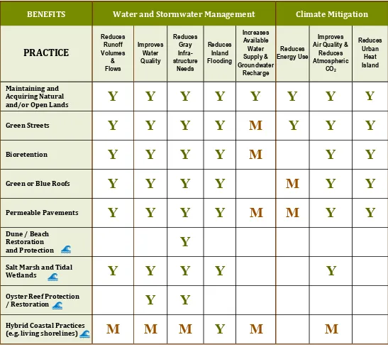
Green infrastructure can help municipalities address issues concerning flooding, erosion, and stormwater, while often lowering short- and long-term costs compared to traditional gray infrastructure. The table seen here describes some of the direct and indirect benefits associated with the implementation of green infrastructure in coastal areas.
Table modified from “The Value of Green Infrastructure: A Guide to Recognizing its Economic, Environmental, and Social Benefits,” Center for Neighborhood Technology and American Rivers, 2010 and NOAA Office of Coastal Management “Introducing Green Infrastructure for Coastal Resilience” Workshop in Providence, 2017.
PRACT)CE
Salt Marsh and Tidal
Wetlands
Y
Y
Y
Y
Y
Oyster Reef Protection
/ Restoration
Y
Y
(ybrid Coastal Practices
e.g. living shorelines
M
M
M
Y
M
M
9
10
The integrated design process brings together an inter-disciplinary team to ensure that design solutions and strategies are formulated to promote multiple benefits. Stakeholders understand the significance of the problem, learn from each other, and identify commonalities and differences, usually leading to enhanced design out-comes and improved return on investment.
The process may include multiple state and municipal departments (e.g., planning, municipal water and sanita-tion, parks and recreasanita-tion, and commerce) and city or town councils. Additionally, non-profits, the private sector, academia, and neighborhood groups should be involved early in the process to promote buy-in. Importantly, include those responsible for maintenance from the beginning.
By using an integrated design process municipalities can address critical needs comprehensively and avoid one-size-fits-all solutions. This process can help integrate priorities such as sustainability, resilience to the impacts of climate change, access to natural assets, open space and historic preservation, social equity, economic devel-opment, community safety, and fiscal responsibility in long-term municipal planning initiatives.
While implementing an integrated design process can be challenging and time-consuming, the improved outcomes usually justify the time and effort. Project planners should proactively discuss when the integrated design process is indispensable or encouraged, or when it could be used with a smaller team to match the scale of the project.
The integrated design process includes:
1. Clear and continuous collaboration among decision makers, practitioners, and other stakeholders from the conceptual phase to the project’s completion; 2. Active outreach to community members directly
affected by green infrastructure projects during the planning, design, and implementation phases; 3. Attention to detail that continuously revisits short
-and long-term project goals established during the initial group design meetings;
4. Identification and inclusion of the environmental, economic, and social benefits of green infrastructure design (see Question 2).
Design charrettes:
The design charrettes with members of the integrated design teams for the Oakland Beach (Warwick) and Wickford (North Kingstown) case studies were critical moments for the GRIP project. Practitioners from various backgrounds including landscape architecture, storm-water management, coastal habitat and geology, and policy and regulation, as well as municipal leaders and staff from planning, construction, and maintenance departments shared their knowledge and experience. The project sites were viewed as open canvases, with participants exchanging ideas, approaches, and technical expertise while making critical design decisions. Partici-pants overlaid various elements, including vegetation and green infrastructure on large site maps to develop designs. The exercise allowed team members to envision the project and discuss pros and cons associated with various alternatives. The conceptual designs are illustrat-ed beginning on page 28.
3
Key Resources:
• Enhancing Sustainable
Communi-ties With Green Infrastructure, EPA
12
The complex dynamics of coastal environments are amplified by increasing changes in sea level, storm patterns, flooding, and erosion. These circumstances demand green infrastructure unique to coastal issues. Meanwhile, green stormwater infrastructure techniques generally designed for inland locations must be adapted to accommodate additional stressors when applied on the coast.
Large-scale issues such as climate change, shoreline erosion, or polluted embayments cannot be solved in isolation. An integrated design process that brings together an interdisciplinary team considers the whole
system — both coastal and inland — and often reveals the most impactful opportunities, which should be incor-porated early in the design process.
There is no “one-size-fits-all” approach. Instead, coastal and inland green infrastructure approaches complement each other to address overall impacts from different threats, which often manifest themselves on the coast. Applying a coastal lens to design can help to shape successful projects; these considerations can be institu-tionalized within local standards:
What are Some Key Design Considerations?
4
•
Design life
— Make long-term decisions that consider the project’s lifecycle demands and costs. While a 20-year design life is often used, a green infrastructure project with a shorter design life can still be effective. Periodic review and/or retrofits help address changing coastal conditions. Wickford’s Brown Street parking lot already floods during extreme high tides and is vulnerable to sea level rise. That said, the GRIP design is based on a 20-year design life that would reduce nuisance flooding and pollutants entering the harbor while longer term solutions can be explored.*•
Watershed management
— Dynamic coastal conditions and densedevelopment may limit design options directly on the coast. Often, it is best to identify upland sites where stormwater can infiltrate to reduce discharge at the coast. A stormwater plan for a coastal subwatershed can help identify ideal intervention sites.
•
Retrofits
— Where space is constrained, smaller projects that treat some stormwater may still be beneficial. In flood-prone areas, forebays or shallow depressions help remove suspended solids from runoff and provide some water quality improvement.•
Sea level rise, extreme tides, and storm surge
— Where feasible, locate green infrastructure upland of areas impacted by sea level rise and flooding from major storms. For example, in Warwick the design incorpo-rates three feet of sea level rise into the siting on the rain garden.* In 2017, the Rhode Island Coastal Resources Management Council (RI CRMC) updated its sea level rise projections to one foot by 2025, three feet by 2050 and nine feet by 2100, based on NOAA’s high scenario curve.4•
Erosion
— Wave action and stormwater runoff both contribute to coastal erosion.•
Groundwater
— High water tables hinder stormwater infiltration and exacerbate flooding impacts from heavy rain events, extreme tides, and/ or storm surge. This can affect design of green infrastructure techniques that rely on filtration and vegetative uptake; off-site mitigation may be preferable in these circumstances.•
Design capacity
— Despite increasing rainfall in-tensity, green stormwater infrastructure designed to treat the first inch of rainfall effectively treats the “first flush” of pollutants from a given storm.•
Impervious areas
— Identify impervious areas that can be removed, reduced, or replaced with permeable surfaces. Infiltrating stormwater near its source reduces stress on existing infrastructure and reduces water quality impacts of direct discharge into surface water.•
Vegetation
— Use coastal-tolerant plants in antici-pation of plants being sprayed or inundated with salt water.•
Maintenance
— Design with maintenance in mind. At the Marine Avenue entrance to Newport’s Cliff Walk, the GRIP team’s proposed green infrastructure design manages stormwater using native wildflowers and grasses swales instead of stone, higher -maintenance perennials, and woody vegetation. This decision reduces the maintenance burden and enhances habitat value.*•
Education
– Use interpretive signs to explain chang-ing coastal conditions and the benefits of green infrastructure.* See case studies and conceptual
designs beginning on page 26
Special consideration for coastal areas
Key Resources:
• The Need to Reduce Impervious
Cover to Prevent Flooding and Protect Water Quality, RI DEM
• Urban Coastal Greenway
Design Manual, RI CRMC
• Rapid Property Assessment
Coastal Exposure(Rapid PACE)
mapping tool helps to understand coastal conditions, URI CRC
15 Maintenance is often an after-thought, but is one of the most
important aspects of initial design. Maintenance affects the long-term efficacy of a green infrastructure system, thereby impacting the municipality’s long-term return on investment. Furthermore, because green infrastructure is often highly visible to the public, overgrown and unsightly projects lead to public complaints and create uncertainty for using this beneficial approach.
Landscape architects and green infrastructure specialists should work with municipal engineers and parks department staff to better understand local maintenance preferences so they can be incorporated into project designs.
The GRIP project and the Rhode Island Green Infrastruc-ture Coalition have led hands-on trainings with the municipal staff members responsible for maintaining installations that resulted in this list of best practices and lessons learned.5
The Rhode Island Nursery & Landscape Association’s regis-tered apprenticeship program provides on-the-job training including green infrastructure.
Maintenance considerations:
•
Design green infrastructure systems with maintenance in mind. The departments that will be responsible for maintenance must be included during the design phase. Minimally, the staff need to know where pro-jects are located, the maintenance requirements, and the roles they are expected to play.•
Green infrastructure designs with grass and soil filters can be as effective for water quality treatment as shrubs or perennials, and easier for municipalities to effectively maintain.•
Design green infrastructure systems with easy-to-clean and effective sediment collection. Sediment should be monitored, captured, and removed during routine maintenance rounds before it enters the vege-tated portion of the system.•
Anticipate that plants in coastal areas will be sprayed or inundated with salt water and sand. Use appropri-ate coastal-tolerant plants.•
Green infrastructure plantings will evolve over time — plan for this change.5
Why is Planning for Maintenance
Critical to the Design Process?
•
What type of maintenance is most appropriate for the owner of the facility?•
What type of maintenance is most appropriate for the site (e.g., mowing, vacuuming permeable pavement)?•
Who will perform the maintenance (e.g., municipal staff, volunteers, contractor) and what equipment is available? maintenance, and replacement of components (e.g., permeable pavement, plants)?Questions to consider when designing
green infrastructure include:
Key Resources:
• RI Stormwater Design and Installation
Standards Manual, Appendix E – Guidance for Operations and Mainte-nance plans
• Operation and Maintenance
Considera-tions for Green Infrastructure, EPA
• Green City, Clean Waters: Green
16
6
(ow Do You Start to Frame Decision Making
About Green )nfrastructure?
• RI Stormwater Design and Installation Standards Manual
• RI Stormwater Solutions Provides public awareness of stormwater impacts and solutions and outreach materials for municipal use
• RI Low Impact Development Site Planning and Design Guidance Manual Comprehensive approach to managing stormwater, including examples and model ordinances
Key Resources:
Commonly, green infrastructure is implemented on a site-by-site basis, without a watershed-wide vision. In such instances, the focus must be on meeting Rhode Island Department of Environmental Management (RI DEM) and/or Rhode Island Coastal Resources Manage-ment Council (RI CRMC) standards, in addition to municipal standards. The Rhode Island Stormwater Manual outlines the five groups of structural best man-agement practices (BMP) and associated practices that can be used to meet standards for low impact design, water quality treatment, groundwater recharge, flood storage, and other criteria. Coastal green infrastructure interventions designed to reduce erosion and coastal flooding are regulated by the RI CRMC program. Beyond the site-by-site approach, it is important to im-plement a project that is suitable to your municipality’s context. Technical, situational, and social elements can influence decision making. Technical elements include the capacity of the municipality to design, implement, and maintain designs of varying complexity. Situational elements are those outside the control of the municipali-ty, such as a new state regulation or a natural disaster. Social elements include the level of public support for changing the paradigm from gray to green infrastructure and its multiple community benefits.
Taking an even broader and more proactive view, up-dating municipal stormwater standards and procedures, subdivision regulations, and comprehensive plans to explicitly incorporate green infrastructure may be the most effective method for improving stormwater management, water quality and coastal resilience. Although time consuming, this is a relatively inexpen-sive intervention that will make communities more resili-ent over time. Municipalities that institutionalize green infrastructure in their foundational documents are better able to implement projects that achieve multiple com-munity goals. For example, some communities have developed green infrastructure strategies that outline guiding principles such as flood management, enhanc-ing bio-diversity, and connectenhanc-ing people to nature.6
The Rhode Island Low Impact Development Guide provides specific recommendations and innovative ordi-nances that Rhode Island cities and towns have already adopted. In addition, the Green Infrastructure Coalition highlights examples of local projects.
Insights from the GRIP team:
1.
The goal should be to begin, not to finish.
Better stormwater management is a long-term endeavor. Projects should be site-based solutions that play to community strengths and contribute to long-term planning goals, not near-term, one-size-fits-all packag-es an engineer or developer may offer.2.
Small projects can be effective.
For the past decade, engineers and regulators have been distracted by managing the one-inch storm event. This standard is economic and achievable for new development, but often unrealistic when undertaking a redevelopment project or retrofit — the dominant project types on the eastern seaboard — due to existing conditions and interests. In these situations, smaller-scale interventions still help address larger problems within the neighbor-hood. Studies show that even undersized stormwater treatment systems used in redevelopment projects can perform remarkably well and generate significant water quality improvements.73.
Learn
-
by
-
doing.
Communities are in the earlystages of the green infrastructure era, with decades of innovations and adaptations ahead. Lessons learned from interdisciplinary approaches, pilot projects, and post-implementation monitoring programs will all help inform future decision making in the field.
4.
Be inclusive and open
-
minded.
Diverseper-spectives result in creative, locally appropriate, and multifaceted solutions. Municipal field staff and decision makers, for example, often have pragmatic and innova-tive ideas, so should be included in the engineering and design process. Departments in charge of maintenance should be intimately involved from the start to ensure long-term success.
18
Coastal green infrastructure can incorporate a wide variety of plant types including flowering perennials, grasses, shrubs, vines, and trees. Making thoughtful decisions about what plants to include will improve a project’s positive impact.
•
Context matters. Clarify project goal(s), understand the type of green infrastructure solution being implemented, and consider the geographic area (e.g., coastal vs. inland) and growing conditions. Plants that may be perfect for an inland residential rain garden designed to manage stormwater may not be appropriate for a coastal bank regrading project designed to address erosion.•
Soil for bioretention should be specified according to the performance requirements, generally suited for a variety of plant species with considerations including onsite hydrology, among others. Amend-ments, such as compost, may not be appropriate unless specified by the engineer.8 See all casestudies at the end of the booklet for examples.
•
The project’s plant community will serve importantfunctions; plants should be selected with those functions in mind. Green infrastructure systems commonly rely on plants to hold soil, filter contami-nants, absorb nutrients, and/or capture water where it falls, among other functions. Different
plants perform different functions, so a variety of plants will likely be required to meet a project’s needs.
•
The project’s plant community will evolve over time; this should be planned for to avoid regularly over-turning and replanting the site.•
Well-designed projects can provide habitat for polli-nators and other species such as migratory birds. Whenever possible, native plants should be used as these are adapted to local conditions and more likely to enhance habitat.•
When selecting plants, design with maintenance in mind. A simplified, low-maintenance plant palette can help ensure the project does not degenerate over time, and will reduce maintenance costs. Consider who will be maintaining the site, the equipment available, and the required budget during the design phase.•
The Newport conceptual design illustrates a bio-retention system using grasses (e.g. New England Wet Mix), native wildflowers and no woody vegeta-tion, providing an attractive yet low maintenance mowing alternative. The infiltration rate and water quality treatment using grass or native plants have been shown to be the same.97
What are the Considerations for Appropriate
Plant Selection?
Key Resources:
• RI CRMC Coastal
Landscapes Program
• RI Coastal Plant Guide
• Rhody NativeTM
• Coastal Stormwater
Management Through Green Infrastructure: A handbook for municipalities, MA
20
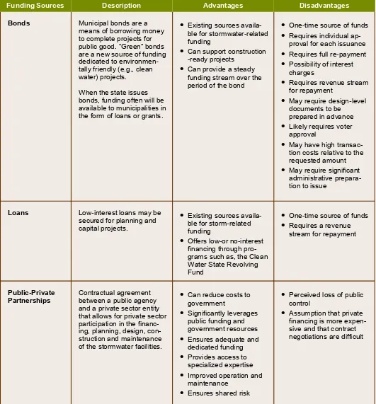
Communities are using diverse funding sources and financing options to implement green (and gray) infra-structure projects. It should be noted that some funding sources are more applicable to implementing new projects while others apply to operations and mainte-nance.
In Rhode Island, municipalities have used a mix of fund-ing sources to pay for green infrastructure projects
including grants, loans, municipal bonds, and general revenue monies. Various state and federal agencies have programs that help fund green infrastructure projects including the Rhode Island Department of Envi-ronmental Management, Rhode Island Coastal Re-sources Management Council, Rhode Island Emergency Management Agency, Natural Resources Conservation Service, Rhode Island Department of Transportation, and the Rhode Island Infrastructure Bank.
8
(ow Do Municipalities Fund Green )nfrastructure?
Funding Sources Description Advantages Disadvantages
Taxes /
General Funds Funds raised through property, income and sales taxes that are paid into a general fund.
•
Consistent from year-to-year, but can fluctuate if not earmarked for GI•
Utilizes an existingfund-ing system
•
Competition for funds•
Tax-exempt propertiesdo not contribute
•
System is not equitable(e.g., does not fully reflect contribution of stormwater runoff)
Fees Funds raised through
charges for services such as inspections and permits.
Funds raised through devel-oper impact fees are one-time charges involved with new development.
•
Specific permit and in-spection fees allow for more direct allocation of cost for services provided•
Addresses potentialstormwater impacts related to new construction
•
Funding not available for larger projects or system-wide improvements•
Developer impact feesmay be an unreliable source when develop-ment slows – due to market downturns / contractions
•
Requires administrative framework to assess and manageStormwater
Utility Funds raised through user fees, with the revenues going into a separate fund to be used only for storm-water services.
•
Dedicated funding source•
Directly related tostorm-water impacts
•
Sustainable, stablerevenue
•
Improved watershed stewardship•
Addresses existing stormwater issues•
Feasibility study required for implementation, fee structure and administra-tion of utility•
Approval by vote of local legislative body•
Perception by the public of a “rain tax”Grants Federal, state and private
foundation grants provide funding for planning, de-signs, and “shovel ready” construction for water quality, habitat or flood mitigation improvements.
•
Existing sources availa-ble for storm-related•
Often requires matchingfunds
21
Key Resources:
• RI Infrastructure BankCleanwater State Revolving Fund• Getting to Green: Paying for Green
Infrastructure, EPA
Funding Sources Description Advantages Disadvantages
Bonds Municipal bonds are a
means of borrowing money to complete projects for public good. “Green” bonds are a new source of funding dedicated to environmen -tally friendly (e.g., clean water) projects.
When the state issues bonds, funding often will be available to municipalities in the form of loans or grants.
•
Existing sources availa-ble for stormwater-related funding•
Can support construction -ready projects•
Can provide a steady funding stream over the period of the bond•
One-time source of funds•
Requires individualap-proval for each issuance
•
Requires full re-payment•
Possibility of interestcharges
•
Requires revenue stream for repayment•
May require design-level documents to be prepared in advance•
Likely requires voterapproval
•
May have high transac-tion costs relative to the requested amount•
May require significantadministrative prepara-tion to issue
Loans Low-interest loans may be
secured for planning and capital projects.
•
Existing sources availa-ble for storm-related funding•
Offers low-or no-interest financing through pro-grams such as, the Clean Water State RevolvingPartnerships Contractual agreement between a public agency and a private sector entity that allows for private sector participation in the
financ-•
Significantly leverages public funding and government resources•
Ensures adequate anddedicated funding
•
Provides access tospecialized expertise
•
Improved operation andmaintenance
•
Ensures shared risk•
Perceived loss of public control•
Assumption that private financing is more expen-sive and that contract negotiations are difficult9
What are the Barriers to Adopting Green
)nfrastructure? What are the Solutions?
Technical and Physical
Barriers:
•
Benefits are not widely known•
Lack of data on benefits, costs, andperformance
•
Insufficient technical expertise•
Designs do not consider future conditionsSolutions:
•
Educate municipal staff and local developers about pros and cons•
Use a learn-by-doing approach via pilot projects to gather data and experience relevant to local conditions•
Identify technical training opportunities to equip local staff and boards with the knowledge to inform and enhance proposed designs, there-by avoiding cookie-cutter solutions and ac-counting for local conditions•
Include projected storm impacts and sea level rise in design criteriaLocal Example:
During the Warwick and Newport GRIP project engineers, designers, and maintenance staff met on site to review challenges and successes, providing opportunities to incorporate practical experience in future designs, retrofits, and planning decisions.
Financial Barriers:
•
Lack of data on costs, economic benefits•
Perceived high short- and long-term costs•
Lack of funding for implementation andmaintenance
Solutions:
•
Institute monitoring plan for GI projects to track performance and costs over time•
Develop Cost Benefit Analysis to illustratefinancial benefits
•
Consider triple-bottom-line benefits•
Incorporate GI into other projects (e.g., install bioswales during parking lot maintenance) to maximize available funding opportunities•
Advance innovative local financing strategies,such as stormwater utility districts
•
Advocate for state and local bond funding•
Include relevant GI projects in hazardmitiga-tion plans for post-disaster funding
•
Clarify maintenance expectations with the municipality and community groups to help insure long-term successLocal Example:
RI Infrastructure Bank provided financing for a GI project at Bristol Town Beach. Permeable pave-ment, rain gardens, and bioswale installations reduced the runoff and beach closure days while increasing beach revenue.
Chart based on other communities nationwide, as seen in “Barriers and Gateways to Green Infrastructure, Clean Water America Alliance” and adapted with input
from “Introducing Green Infrastructure for Coastal Resil-ience” Workshop in Providence, 2017, implemented by NOAA Office of Coastal Management
Legal and Regulatory
Barriers:
•
Local ordinances and design standards may be lacking, outdated, conflicting, or restrictive•
Water, land use, and property rights laws maynot be supportive
•
Local and/or state permitting process can be confusing•
Lack of local capacity to oversee and enforce stormwater managementSolutions:
•
Update local plans, regulations and standards to promote GI and create incentives for retro-fits and new development•
Clarify permitting process and roles•
Institutionalize pre-application meetings with state agencies, municipality, and applicant to promote agreement of the best approach•
Adopt provisions for third-party, expertreviews within local regulations
Local Example:
Newport incorporated language about GI into its comprehensive plan, redefining open space to include GI, and committing to evaluating city facilities to identify opportunities to implement GI and include key initiatives in its capital improve-ment programs.
Community and Institutional
Barriers:
•
Cultural perceptions of green vs. gray infrastructure•
Insufficient information on benefits for municipal decision makers and staff, developers, landscape contractors, and the public•
Aesthetically disagreeable to some people•
Lack of interagency and communitycooperation
Solutions:
•
Educate community about benefits and available incentives•
Implement demonstration pilot projects to help educate the community, build capacity and generate buy-in for GI projects•
Work with state agencies, academic partners, and non-profit organizations to develop train-ing and outreach programs to build local capacity, promote cooperation, and stimulate jobs•
Engage neighborhood in “adopt-a-spot” agreements where appropriateLocal Example:
24
Providing Resilience Education for Planning in RI (PREP-RI). URI Coastal Resources Center / RI Sea
Grant. Delivers tools, training, technical assistance and outreach to strengthen the capacity of RI coastal commu-nities to assess, plan for and adapt to extreme weather events and climate-related hazards.
RI Coastal Training Program, Narragansett Bay Estu-arine Reserve. Provides decision-makers with practical and relevant science-based information and skills need-ed to address critical resource management issues of concern.
RI Nonpoint Education for Municipal Officials & RI Stormwater Solutions, URI Cooperative Extension. Promotes public awareness of stormwater impacts and solutions and provides outreach materials for municipal use by providing information, education, and assistance to communities.
RI Nursery and Landscape Association (RINLA).
Represents the $2.5 billion agriculture and landscape industry in Rhode Island. Member companies provide the service and supply chain regarding integrated resilience and innovation, climate change and green-blue infra-structure. RINLA’s registered apprenticeship program provides on-the-job training including green infrastruc-ture.
Save The Bay. Focuses on water quality, coastal habitat protection, and restoration of Narragansett Bay. Provides community assistance in design and implementation of coastal GI, as well as statewide policy initiatives.
University of New Hampshire Stormwater Center.
Practical resources based on dynamic research, testing, and education for water managers, planners, and design engineers in New England. “Breaking Through,” the center’s 2016 report, highlights different techniques and quantifies their effectiveness.
25
Other Rhode Island Organizations
RI Green Infrastructure Coalition.
Promotes Green Infrastructure statewide through educa-tion, funding support, models of working with govern-ments, and communication. Focal areas include Provi-dence-Metro and Newport-Aquidneck Island.
Rhody Native Project, RI Natural History Survey. This organization grows hyper-local varieties of RI plants, which outperform imported varieties of the same species. It can help select appropriate plantings for a green infrastructure project.
RI Association of Conservation Districts. Works in partnership with land owners, municipalities, agencies, and organizations to reduce non-point sources of pollu-tion and improve quality of land and water in RI.
RI Sea Grant Legal Program and Marine Affairs Insti-tute at Roger Williams University. Provides a forum for marine and coastal policy and legal issues. Graduate student law fellows support selected legal research top-ics of relevance to agencies and organizations.
Roger Williams University Community Partnerships Center. Leverages university resources and partner-ships to support a wide spectrum of nonprofit, municipal, and community groups to carry out projects.
Public Agencies
Rhode Island
RI Coastal Resources Management Council.
The state coastal zone management agency with plan-ning and regulatory authority within the coastal zone. CRMC works with municipalities to advise on coastal GI
options and techniques along with permitting where required.
RI Department of Environmental Management Office of Water Resources. Establishes minimum standards and regulations for the protection of surface waters, groundwater and wetlands. Administers stormwater per-mitting and provides assistance in planning and design through pre-application meetings. Provides guidance manuals for Low Impact Development and GI and man-ages grant programs that may provide funding for GI.
RI Infrastructure Bank and the Clean Water Revolving Fund. Provides access to below market interest rate loans for GI projects, among others.
RI Department of Transportation Stormwater Man-agement Program. Works to reduce pollutants that enter the state’s network of drains and storm sewer systems to protect and restore water resources and maintain permitting standards. Coordinates with munici-palities where RIDOT drains are connected to the municipal systems.
National
Environmental Protection Agency Green Infrastruc-ture Wizard. Resources and tools to support water management and community planning decisions.
Natural Resource Conservation Service, RI office. Provides technical assistance to farmers, private land-owners and managers.
Setting
Oakland Beach overlooks Narragansett Bay and is an important recreational, historic, and economic hub in the City of Warwick. This area is popular for swimming and fishing and is a summer destination for many fami-lies from urban communities. Oakland Beach offers amenities such as a beach, a playground, restaurants, and a place to park the car to look at the bay.
Challenge
Oakland Beach has impaired water quality and is vulnerable to coastal flooding, storm surge, and sea level rise. Stormwater runoff from dense residential and commercial development results in frequent beach closures that raise public health, safety, and economic concerns. Flooded parking spaces, reduced access to the beach and the potential for impact to the rock revet-ments and groins built by the federal government decades ago were identified as primary concerns.
Solution
During the conceptual design process the core team and stakeholders recognized the need to determine how the surrounding watershed influences the coastal impact of storms, flooding of the parking lot, and water quality at the beach. Several solutions were evaluated, including reconfiguring the parking lot to reduce imper-vious surfaces near the shore. The GRIP team decided to focus this pilot project on shorter-term, incremental changes that may build support for future retrofits on-site and throughout the watershed.
Proposed improvements include a rain garden bio -retention system and dune enhancement that address many identified problems, while benefitting public health, tourist safety, and habitat. Maintenance costs were also considered. The team discussed rising sea levels, tidal surges, ten-year return period coastal storm events, and the design life of projects. These considerations are reflected in the conceptual design. While not a traditional green infrastructure approach, the city installed Big Belly solar trash compactor recep-tacles at Oakland Beach to reduce litter entering the
doing approach for building capacity to plan, design, and manage
green infrastructure projects in coastal areas. The case studies
provide a forum for learning and illustrate the use of coastal green
infrastructure. Each was based on a unique set of circumstances,
but the lessons learned are applicable to any Rhode Island
munic-ipality facing similar issues. The GRIP partnership selected these
sites because they are currently experiencing severe impacts due
to their proximity to the coast, their level of public use, and/or their
historic and economic value.
Oakland Beach, Warwick, R)
34
Setting
Marine Avenue is a popular public access route to the historic Cliff Walk and Belmont Beach, and offers an important link between public and private properties. This access provides visitors with the opportunity to experi-ence the scenic beauty of the Newport shoreline, Gilded Age architecture, and the plants and wildlife of Rhode Island’s coast.
Challenge
During rain storms, runoff from neighborhood lawns and roads carries nutrients, bacteria, and sediment down Wetmore and Marine avenues and sends these harmful pollutants into the cove. The runoff also erodes the path to the Cliff Walk. These impacts impede safe public ac-cess to the walk and the area’s many recreational uses including walking, swimming, surfing, and fishing.
Solution
A bioretention area that slows the flow and intercepts, filters, and infiltrates stormwater runoff was designed. Swales, transitions, and landscaping use native plant mix-es (e.g., wildflower, grass) as an alternative to stone and woody vegetation; this will help reduce maintenance bur-den while enhancing aesthetics and habitat values.
The proposed design is above the flood zone. The im-provements address the challenges identified above while also improving tourist safety, recognizing historic uses, and keeping maintenance affordable.
Marine Avenue, Newport, R)
Cliff Walk, near
35 Photos this page:
38
Setting
The Brown Street waterfront parking lot is in the heart of historic Wickford Village. It is a key element to support this historical, recreational, and economic hub in North Kingstown. The area is adjacent to a natural harbor and surrounded by a large collection of 18th century homes and businesses.
Challenge
This low-lying area is vulnerable to flooding from rain events and coastal storms. During extreme high tides, sea water comes up through catch basins and low spots in the granite block wall. Aging subsurface infrastructure drains untreated stormwater from the parking lot to the harbor; the substrate is likely not suitable for infiltration. These issues will be exacerbated in the future with sea level rise and increased storm intensity. The parking lot serves multiple uses for business and waterfront access, and has multiple owners, both public and private.
Solution
This location demonstrates the impacts of coastal hazards such as rising tides and storm surge, and offers no easy solution. The GRIP team agreed to look at short- and medium-term options (20-year design life) to enhance resilience while long-term options are explored. The team considered opportunities to minimize nuisance flooding and reduce pollutants entering the harbor, such as regrading selected low areas, modifying catch basins and outlet pipes, and installing elements of green infrastructure where feasible The team aimed to enhance access to the waterfront and public space while maintaining the park-ing lot's parkpark-ing capacity, critical to local business. Design recommendations included: expansion of walkways, reconfiguration of parking spaces and traffic flow, and installation of landscape features. In these and other ongoing efforts in Wickford, the town continues to build on relationships with businesses and the public to identify options and implement actions.
44
Endnotes
1 Melissa Barker, City of Newport, GIS Coordinator, Personal Communication. Based on information from RI GIS, using a 5-mile coastal buffer of 2010 Census track information.Data is publicly available through RIGIS http://www.rigis.org
2 Watershed Counts, Climate Change indicator http://watershedcounts.org/climate.html
3 2014 Economic Intersections of Rhode Island: a private sector-generated action agenda executive sum-mary http://www.rifoundation.org/Portals/0/Uploads/ Documents/Economic_Intersections.pdf
4 Rhode Island CRMC relies upon the most recent NOAA sea level rise data to address both short- and long-term planning horizons and the design life considerations for public and private infrastructure. The CRMC policy is to adopt and use the most recent sea level change scenarios published by NOAA (currently Technical Report NOS CO-OPS 083), and the NOAA sea level rise change curves for Newport and Providence as provided in the U.S. Army Corps of Engineers’ online sea level rise calculator tool available at: http://corpsclimate.us/ccaceslcurves.cfm. The Council requires the use of the NOAA high scenario curve for projecting sea level rise for future conditions. In addition, the Council adopts and recommends use of the STORMTOOLS online mapping tool developed on behalf of the CRMC by the University of Rhode Island Ocean Engineering program to evaluate the flood extent and in-undation from sea level rise and storm surge.
5 Nature at Work News. RI Green Infrastructure Coalition, November 2017 https://www.greeninfrastructureri.org/ newsletters/2017-11-20.html
6 Devon County Council Green Infrastructure Strategy, Devon County, U.K., https://new.devon.gov.uk/green infrastructure/strategy/principles-and-strategic-priorities -for-devon
7 Breaking Through University of New Hampshire Storm-water Center 2016 Report, University of New Hampshire Stormwater Center, https://www.unh.edu/unhsc/sites/
default/files/media/unhsc_2016_report_final.pdf
8 Bioretention Soil Specification, University of New Hamp-shire Stormwater Center,https://www.unh.edu/unhsc/
sites/default/files/media/unhsc_bsm_spec_2-28-17_0.pdf
Photography courtesy of Sea Grant Rhode Island. Also, Mark Truman (pg. 1); Janet Freedman (pg. 3); Pam Rubinoff (pgs. 7, 19); Tupelo Design Studio (pgs. 15, 24, 25); Joe Giblin (pg. 17); Scott Weider (pg. 27).
“We’re trying to build a thought process
in which you think toward the future so that
you account for changing conditions”
•
Because the coastline is a dynamic environment, adaptable green infrastruc-ture projects designed to cope with changing conditions, such as sea level rise and storm surge, can be the best option. Unfortunately, green infrastructure is often passed over in favor of conventional gray or hard infrastructure solutions. Working collaboratively with individuals who are receptive to innova-tion and are excited about adopting new ideas is critical for implementing new approaches such as green infrastructure.•
Considering multiple goals, functions, and benefits is an important part of the integrated design process. A successful design should incorporate a variety of priorities brought forward by different stakeholders. These priorities will drive the design with functional elements to benefit recreation, stormwater treat-ment, flood impact reduction, and aesthetics, among others.•
Stakeholder engagement is crucial to ensuring that selected green infrastruc-ture sites are important to the local community. Getting early buy-in from the community and political leaders within an integrated design process is critical.•
On-the-ground design charrettes and site visits increase municipal leaders’and community members’ understanding of the benefits of implementing green infrastructure techniques so they are more open to innovative design ideas. Having a technical expert available to advise and guide participants in these valuable experiential learning opportunities is highly beneficial.