In uence of eographical Conditions on the Spatial Structure of
Jayapura City
$OÀQL%DKDUXGGLQ1,2,*, B. Hari Wibisono2, Budi Prayitno2, and M. Sani Roychansyah2
1)Department of Architecture and Planning Universitas Sains dan Teknologi Jayapura 2)Department of Architecture and Planning Universitas Gadjah Mada
*)&RUUHVSRQGLQJDXWKRUHPDLODOÀQLEDKDUXGGLQ#\DKRRFRP
Abstract. -D\DSXUD&LW\LVVLWXDWHGRQWKHHDVWHUQWLSRI,QGRQHVLDDQGERUGHUVWKHQHLJKERULQJ FRXQWU\3DSXD1HZ*XLQHD31*,WVJHRJUDSKLFDOFRQGLWLRQVDUHYHU\GLYHUVHGRPLQDWHGE\ KLOOVOHDGLQJWRWKHIRUPDWLRQRIVHSDUDWHGXUEDQDUHDV&XUUHQWO\WKHUHDUHWZRPDMRUXUEDQ DUHDV-D\DSXUDDQG$EHSXUD+LVWRULFDOO\-D\DSXUDDQG$EHSXUDZHUHWZRROGWRZQVHVWDEOLVKHG LQWKH'XWFKUXOHQDPHO\+ROODQGLD+DYHQDQG+ROODQGLD%LQQHQ7KH\DUHGHWDFKHGE\6N\OLQH KLOOVWKDWKLQGHUWKHLUFRPSOHWHSK\VLFDOPHUJHU7KHSUHVHQFHRIWZRVHSDUDWHXUEDQDUHDVLQ -D\DSXUD &LW\ LV DOVR UHLQIRUFHG E\ WKH LPDJH SHUFHLYHG E\ WKH UHVLGHQWV UHJDUGLQJ ZLWK WKH SRZHUIXOYLVXDOLPDJHRIWKRVHFLWLHV,WKRZHYHUIRUPVXQLTXHDQGGLVWLQFWLYHSURSHUWLHVLQ WKHVSDWLDOVWUXFWXUHRI-D\DSXUD&LW\7KLVVWXG\H[DPLQHVKRZWKHLQÁXHQFHRIJHRJUDSKLFDO FRQGLWLRQVRQWKHVSDWLDOVWUXFWXUHRI-D\DSXUD&LW\'DWDFROOHFWLRQZDVGRQHWKURXJKGLUHFW REVHUYDWLRQ DQG VWUXFWXUHG LQWHUYLHZV ZLWK UHVSRQGHQWV RI -D\DSXUD DQG $EHSXUD 'LUHFW REVHUYDWLRQZDVFRQGXFWHGWRREWDLQGDWDRQWKHXVHRIODQGWKDWIRUPVSDWWHUQVLQ-D\DSXUD&LW\ DUHD:KLOHFROOHFWLQJGDWDWKURXJKTXHVWLRQQDLUHVFRQGXFWHGWRGHWHUPLQHWKHLPDJHRIUHVLGHQWV RI-D\DSXUD&LW\RQWKHVSDWLDOVWUXFWXUHRIWKHFLW\7KHUHVXOWVVKRZHGWKDWWKHJHRJUDSKLFDO FRQGLWLRQVLQ-D\DSXUD&LW\DIIHFWWKHIRUPDWLRQRIWZRVHSDUDWHSDUWVRIWKHFLW\7KHJHRJUDSKLFDO FRQGLWLRQLVDOVRDQHOHPHQWIRUPLQJDVWURQJVSDWLDOVWUXFWXUHDVDFKDUDFWHULVWLFUHLQIRUFHVWKH YLVXDOLPSUHVVLRQRIWKHH[LVWHQFHRIWZRXUEDQDUHDVZLWKLQ-D\DSXUD&LW\,QLWVGHYHORSPHQW WKHH[LVWHQFHRIWZRXUEDQDUHDVVKRZWKHSHUVLVWHQWFKDUDFWHULVWLFVRI¶WZRFLWLHVZLWKLQDFLW\·
Keywords:JHRJUDSKLFDOFRQGLWLRQVVSDWLDOVWUXFWXUHLPDJH-D\DSXUD&LW\
Abstrak..RWD-D\DSXUDWHUOHWDNGLXMXQJWLPXU,QGRQHVLDGDQEHUEDWDVDQODQJVXQJGHQJDQ
QHJDUDWHWDQJJD3DSXD1HZ*XLQHD31*.RQGLVLJHRJUDÀV.RWD-D\DSXUD\DQJVDQJDW EHUDJDP \DQJ GLGRPLQDVL ROHK SHUEXNLWDQ PHQJDNLEDWNDQ WHUEHQWXNQ\D ZLOD\DK NRWD \DQJ WHUSLVDKSLVDK6DDWLQLWHUGDSDWGXDEDJLDQEHVDUZLOD\DKNRWD\DQJGLNHQDOGHQJDQVHEXWDQ -D\DSXUDGDQ$EHSXUD6HFDUDKLVWRULV-D\DSXUDGDQ$EHSXUDGDKXOXPHUXSDNDQGXDNRWD ODPD\DLWX+ROODQGLD+DYHQGDQ+ROODQGLD%LQQHQ.HGXDDUHDNHNRWDDQLQLGLSLVDKNDQROHK SHUEXNLWDQ 6N\OLQH VHKLQJJD WLGDN PHPXQJNLQNDQ WHUMDGLQ\D SHOHEXUDQ EDWDVEDWDV NHGXD ZLOD\DK NRWD WHUVHEXW 7HUGDSDWQ\D GXD NRWD \DQJ WHUSLVDK GL GDODP .RWD -D\DSXUD MXJD GLSHUNXDW GHQJDQ LPDJH ZDUJD PDV\DUDNDW \DQJ PDVLK PHPSXQ\DL NHVDQ YLVXDO \DQJ NXDW WHUKDGDSNHEHUDGDDQGXDNRWDWHUVHEXW.RQGLVLLQLPHPXQFXONDQNDUDNWHU\DQJXQLNGDODP VWUXNWXU NHUXDQJDQ .RWD -D\DSXUD 3HQHOLWLDQ LQL PHQJNDML EDJDLPDQD SHQJDUXK NRQGLVL JHRJUDÀVWHUKDGDSVWUXNWXUNHUXDQJDQ.RWD-D\DSXUD3HQJXPSXODQGDWDSHQHOLWLDQGLODNXNDQ PHODOXL SHQJDPDWDQ ODQJVXQJ GDQ ZDZDQFDUD WHUKDGDS UHVSRQGHQ -D\DSXUD GDQ $EHSXUD 3HQJDPDWDQODQJVXQJGLODNXNDQXQWXNPHPSHUROHKGDWDPHQJHQDLSHQJJXQDDQODKDQ\DQJ PHPEHQWXN SRODSROD ODKDQ WHUEDQJXQ GL .RWD -D\DSXUD 6HGDQJNDQ SHQJXPSXODQ GDWD PHODOXLNXHVLRQHUGLODNXNDQXQWXNPHQJHWDKXLLPDJHZDUJD.RWD-D\DSXUDWHUKDGDSVWUXNWXU NHUXDQJDQ NRWD +DVLO SHQHOLWLDQ PHQXQMXNNDQ EDKZD NRQGLVL JHRJUDÀV GL .RWD -D\DSXUD PHQJDNLEDWNDQ WHUEHQWXNQ\D GXD EDJLDQ ZLOD\DK NRWD \DQJ WHUSLVDK .RQGLVL JHRJUDÀV LQL MXJD PHUXSDNDQ HOHPHQ SHPEHQWXN VWUXNWXU NHUXDQJDQ \DQJ NXDW VHEDJDL FLUL NKDV YLVXDO \DQJVHPDNLQPHPSHUNXDWNHVDQDGDQ\DGXDDUHDSHUNRWDDQGLGDODP.RWD-D\DSXUD'DODP SHUNHPEDQJDQQ\D NHEHUDGDDQ NHGXD DUHD SHUNRWDDQ PHQXQMXNNDQ NDUDNWHULVWLN \DQJ WHWDS EHUWDKDQ\DLWXDGDQ\D¶GXDNRWDGLGDODPVHEXDKNRWD·
1. Introduction
Jayapura City is the provincial capital of Papua which is situated on the eastern tip of Republic of Indonesia and borders the nation of Papua New Guinea (PNG) to the east. It covers an area of 940 km2 comprising of 5 districts, namely North Jayapura of 5.43%; 6RXWK-D\DSXUDRI$EHSXUDRI +HUDP RI DQG 0XDUD 7DPL RI Those districts comprise of 25 villages and 14 hamlets. Out of total area, around 53% is inhabited as it consists of rough terrains, swamps, and protected forests (Bappeda Kota Jayapura, 2014). The diverse geographical conditions of Jayapura City form separated urban areas. Currently, the community of Jayapura recognizes the cities of Jayapura and Abepura, even though those two cities are located in the administrative region of Jayapura City. The center of Jayapura City is situated at Yos Sudarso Bay, while Abepura City is at Abepura Circle. Those two cities are detached by hills named Skyline.
The well-known two cities within Jayapura City, namely Jayapura and Abepura, are inevitably related to the history of Jayapura City. The area of Jayapura and Abepura was an old town center established during the reign of the Netherlands and the Allies at the beginning of the founding of Jayapura City. The area recently known as Jayapura was previously named after Hollandia Haven, while Abepura was called Hollandia Binnen. Hollandia Haven or ‘Hollandia’ was precisely in Yos Sudarso Bay, a narrow strip of land dominated by hills. Now, this area is the administrative region of North Jayapura and South Jayapura. It was WKH ÀUVW DUHD ZKHUH &DSWDLQ 6DVFKH EXLOW WKH post of a military bivouac and proclaimed the establishment of Hollandia on March 9, 1910. In the meantime, Hollandia Binnen was situated in the hinterland of broader plain. It is currently the administrative region of Abepura District and Heram District. It was also the administrative center of Allied soldiers and later became the central Dutch government after WKH6HFRQG:RUOG:DULQ+RZHYHU7KH Dutch government moved the administrative center to Hollandia Haven in 1958 (Roscoe, 1959; Kambu, dkk., 2009).
Harshorne (1938) mentions the phenomenon of two cities which he calls as the model of Twin City District of Minneapolis–St. Paul, each lies on both sides of the Mississippi. St. Paul is the state capital
of Minnesota (USA), while Minneapolis is the capital of Hennepin County and the largest city in Minnesota. Minneapolis and St. Paul has a distinctive cultural landscape of ‘Twin City district’, in which those cities are almost completely separated, not merely politically but geographically, and yet in close contact with each other along one common zone. The centers of those cities are interdependent despite several differences in cultural traits of each city. Hartshorne argues that the stability of twin city model is likely due to the geographical situation. The structure of the highway is a powerful factor of the stability and two commercial cores with rapid investment strengthened by psychological factors will tend WRUHWDLQLWVXQLTXHJHRJUDSKLFDOIRUPRIWZR cores in different areas.
Budapest, the capital of Hungary, is an example of the city previously consisted of two separate cities of Buda and Pest, each lie on both sides of the Danube. Buda was a hilly area located in the west of Danube, while Pest was a plain area situated in the east of Danube. Buda was the royal palace on the hill serving as the capital of Hungary. Later, Buda joined Pest which was dominant as the commercial and cultural center. The boundary between those two cities was replaced with bridges connecting them (Morris, 1971 in Hartshorn, 1992). Kostof DOVRFRQÀUP7ZLQ&LW\DVWKHFLW\SDLU section which is connected in parallel, for example between the administrative capital with the military base. The link between the city pair section is the main road of military camp to the administrative capital.
In Indonesia, Bandar Lampung as the provincial capital of Lampung is one of the cities whose the formation process is almost similar with Budapest. It is the fusion of two cities of Teluk Betung and Tanjung Karang or well-known as Teluk Betung-Tanjung Karang before named after Bandar Lampung. Both cities were merged into one city, namely Bandar Lampung City, by omitting the indistinct boundaries of those two cities. Teluk Betung is located in adjacent to the Lampung Gulf and Tanjung Karang is situated in higher land in the northern part of Betung Gulf, with approximately 5 km in distance. The absence of a natural boundary between those cities makes there is a framework of the steady city line (Ministry of Internal Affairs, 2013).
development of Jayapura City is distinguished from Budapest or Bandar Lampung. Nevertheless, both of Buda-Pest and Teluk %HWXQJ²7DQMXQJ .DUDQJ ZHUH XQLÀHG LQWR D city by omitting the boundaries, while Jayapura City seems to maintain the dualism of the areas although Jayapura and Abepura have become an administrative area of Jayapura City. The presence of two geographically separated cities within Jayapura City presents the extraordinary character of Jayapura spatial structure attached to most of the visual impression. This study H[DPLQHV KRZ WKH LQÁXHQFH RI JHRJUDSKLFDO conditions on the spatial structure of Jayapura City.
7KHVSDWLDOVWUXFWXUHVKRZVWKHVSHFLÀHG distinctive compositions of a space (Yunus, 'H&KLDUDDQG.RSSHOPDQVXJJHVW that the spatial structure is expressed as the physical planning and design of an open space at a site. Spatial structure is generally the result of distinctive topography as natural properties. While one of the non-natural properties is land-use. The characteristics of spatial landscape commonly rely on three points, namely, the area, the visual degree of enclosure visual, and the visual properties.
2. Research Methods
To assess the spatial structure of Jayapura City, the investigation on the natural and non-natural properties that formed the city including topography and land-use as well as the visual impression of the people was carried out (De &KLDUDDQG.RSSHOPDQ7KHFROOHFWLRQ of data was derived from direct observation, secondary data collection, and structured inteview. Direct observation was performed to obtain the data on land-use shaping the constructed land pattern in Jayapura City. Secondary data was retrieved by collecting supporting data related to the spatial of Jayapura City. In addition, structured interview primary GDWDZDVFRQGXFWHGWKURXJKDTXHVWLRQQDLUHWR ÀQGRXWWKHLPDJHRI-D\DSXUD&LW\UHJDUGLQJ
with the spatial structure of Jayapura City. The respondents were the residents of Jayapura
City who selected randomly. The amount of
respondent can be determined using Slovin formula (in Sugiyono, 2011):
(1)
Where:
n = total sample N = population
e = margin of error, e = 0,1
This formula is used because in this study population size is measured, i.e. the population of Jayapura and Abepura in 2013, where the population of Jayapura is 140.277 inhabitants, and a population of Abepura is 130.298 inhabitants (BPS Jayapura City, 2014). Base on Slovin formula (in Sugiyono, 2011), the total minimum of Jayapura respondent must be taken is 110 respondents, and Abepura respondent is 110 respondents.
3. Results And Discussion
a. The In uence of eographical Condition on Spatial Physical Development
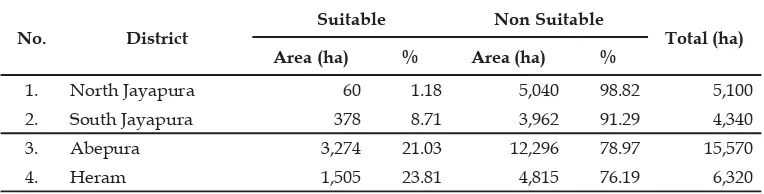
Geographically, Jayapura City is dominated by hills that cause the majority of the land cannot be developed as cultivation area, while the land for cultivation area should be the dominant area. Land suitability of Jayapura City can be examined from the physical aspects, the spatial policy, and the carrying capacity of LQIUDVWUXFWXUHV7KHDUHDPHHWVWKHUHTXLUHPHQW to be developed as cultivation area is 40,492 ha or 43% of the total area, while the non-suitable area is approximately 53,508 ha or 57%. Suitable area for cultivation is located in Muara Tami District, which is 87% of the total suitable area for cultivation. North Jayapura District has the VPDOOHVWIRUFXOWLYDWLRQLHKDZKHUHLV6RXWK Jayapura District has 378 ha (Table 1).
Table 1. S
No. District
Suitable Non Suitable
Total (ha)
Area (ha) % Area (ha) %
1. North Jayapura 1.18 5,040 98.82 5,100
2. South Jayapura 378 8.71 91.29 4,340
3. Abepura 3,274 21.03 78.97 15,570
No. District Suitable `Non Suitable Total (ha)
Area (ha) % Area (ha) %
5. Muara Tami 35,274 43.71
Total (ha) 40,492 43.08 53,508 94,000
S : , 20 4 )
From the land positioning based on the assessment of the productive area in Jayapura City, the optimal land has been utilized for the urban productive area is at the northern part of Jayapura City. The areas developed as urban areas of Jayapura City include North Jayapura
District, South Jayapura District, Abepura District and Heram District. Nevertheless, the suitable area mostly located in Muara Tami District has not been optimized as urban area as it is dominated by agricultural land (Figure 1).
Source: Bappeda Kota Jayapura, 2014
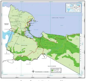
Figure 1. Land Suitability Map of Jayapura City
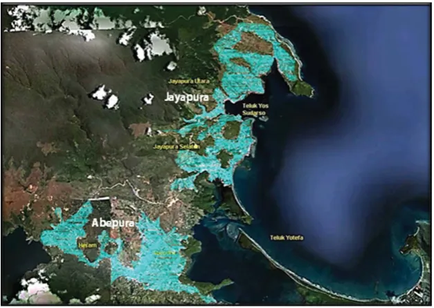
The geographical conditions of Jayapura City lead to the development of the built-up area in fragmentary. From the assessment of the urban built-up area, there are two urban areas situated in the north and the south part (Figure 2). The urban areas in the northern part of the Jayapura City are North Jayapura and South Jayapura District, while the urban areas in the southern part of Jayapura City are Abepura District and Heram District. Nowadays, the residents of Jayapura City recognize Jayapura and Abepura within the city. Jayapura region covers North Jayapura and South Jayapura District, while Abepura region includes Heram District and Abepura District. Geographically,
Source: Google Earth, 2013 (Data analysis)
Figure 2. The urban areas of Jayapura City
Jayapura area serves as the central government and the economy. Jayapura is situated on Yos Sudarso Bay has a port that serves as a major transportation node nationwide. As the center of economic activity, Jayapura is strongly supported by the activity at the Port of Jayapura with an important role in receiving various economic commodities from other regions and also distributes goods to destinations around Jayapura. Various facilities economy is growing rapidly in this area. Currently, developments in Jayapura tend to have saturated because the availability of suitable land is very limited because its topography is dominated by hills.
Abepura is located in hinterland area which serves as a center of growth and the economy. Abepura has a major role to the growth of the region around Jayapura City. Abepura also a transport node as a transit area on the main route leading to the buffer zones around Jayapura City which is the center of agricultural production. As a growth center, Abepura experiencing rapid economic development in terms of providing economic facilities are supported by the availability of VXLWDEOHODQGLVTXLWHVSDFLRXVFRPSDUHGWRWKH Jayapura area.
b. The In uence of eographical
Conditions on Residents’ Visual Image The geographical conditions of Jayapura City prevailed by the hills/mountain in which the urban areas are constructed on each side of WKH KLOOVPRXQWDLQ EURXJKW D FRQVHTXHQFH RI the designation of the strong spatial structure with the hill as urban spatial landscape (Figure 3). It is the particular characteristic of the spatial image which is able to affect person’s interpretation or impression on a space in accordance with the attached visual image.
addition, as many as 74,55% respondents from Abepura consider that Jayapura and Abepura are two separate cities and 25,54% respondents think Jayapura and Abepura is one single FLW\ (QWLUHO\ UHVSRQGHQWV SHUFHLYH Jayapura and Abepura are two different cities
ZLWKLQ-D\DSXUD&LW\DQGUHVSRQGHQWV think that Jayapura and Abepura are non-separated cities. It indicated that most of the residents of Jayapura City assume that Jayapura and Abepura are two separated cities within Jayapura City (Table 2).
Figure 3. The hills shape a determined spatial structure as landscape element in urban areas of Jayapura City Source: Research survey, 2014
Table 2.
Image on the existence of two cities
Total
Yes % No %
Respondents of Jayapura 80 72,73 30 27,27 110
Respondents of Abepura 82 74,55 28 25,45 110
Total 58 220
S : , 20 4
)URP WKH UHVXOW RI UHVSRQGHQWV assuming that Jayapura and Abepura are two VHSDUDWHGFLWLHVWKHUHZDVDIROORZXSLQTXLU\ on the image of Jayapura and Abepura as WZRVHSDUDWHFLWLHV7KHTXHVWLRQQDLUHRQWKH image why Jayapura and Abepura seem to be two separated cities instead of one single city demonstrated that 47,53% respondents opt up Skyline hills as the reason; 22.22% respondents opt up the distance between those areas; 9.88% respondents opt up the availability of only one arterial highway between those areas; 7.41% respondents consider the different topography
of hilly Jayapura and relatively plain Abepura; DQGUHVSRQGHQWVRSWXSWKHKLVWRU\RI those areas as old cities of Hollandia Haven and +ROODQGLD%LQQHQ)URPWKHTXHVWLRQQDLUHWKH geographical element which is the Skyline hills as the “boundary” is the most attached image perceived by the residents of Jayapura City. The opinions demonstrated the respondents’ image on the distinctive visual characteristic of a space. Nevertheless, it is evidenced that JHRJUDSKLFDOFRQGLWLRQVDUHWKHPRVWVLJQLÀFDQW factor regarding with the spatial image of distinctive visual characteristic (Table 3).
Table 3.
Why Jayapura and Abepura seem to be two separated cities instead of a single Jayapura
City
Respondents of Jayapura
Respondents of
Abepura Total %
Why Jayapura and Abepura seem to be two separated cities instead of a single Jayapura
City
Respondents of Jayapura
Respondents of
Abepura Total %
Distance 14 22 22.22
Only one main access road available, in
addition to alternative roads 12 4 9.88
Topography, Jayapura is hilly while
Abepu-ra is plains 8 4 12 7.41
History of the two old cities 4 17 21
Total 80 82 100.00
S : , 20 4
The result of a survey on the image of the range of Jayapura and Abepura showed that the image is affected by geographical factors in addition to the historical image of those cities. It demonstrated by the option of “other answers” explicated by the respondents, that generally, they provided answers showing their strong impression on the spots where Jayapura and $EHSXUD ZHUH HVWDEOLVKHG IRU WKH ÀUVW WLPH Those spots are currently the centers of the cities, Jayapura at Imbi Park and Abepura at Abepura Circle.
Triangulation of data obtained from observations on the geographical conditions DQGWKHTXHVWLRQQDLUHLQGLFDWHGWKHPDLQUHDVRQ for the formation of Jayapura and Abepura was the geographic conditions of Jayapura City. They are separated by Skyline hills. It is also a FUXFLDOHOHPHQWRIVSDWLDOVWUXFWXUHDVDXQLTXH visual characteristic perceived by most of the residents of Jayapura.
4. Conclusion
The spatial structure of a city is assessed from the physical and geographical conditions, as well as the visual image perceived by the residents. Geographical conditions lead to the formation of two parts of Jayapura City that are separated by Skyline Hills. Analysis of
topography and land-use indicated the presence of two primary urban areas, namely, Jayapura and Abepura. This situation has caused the disconnection of those two by non-building area, thus, it seems to be unfeasible to fuse the boundaries between those areas. Historically, Jayapura and Abepura were two old cities established in the early of Jayapura City. Both of them had their own town centers constructed simultaneously during the establishment of the city. The center of Jayapura is located at Imbi Park (Taman ,PEL) and Abepura is located at Abepura Circle (/LQJNDUDQ$EHSXUD).
The results showed that the geographical FRQGLWLRQV RI -D\DSXUD &LW\ LQÁXHQFH RQ the formation of two separate urban areas, Jayapura and Abepura. The presence of two geographically separate urban areas in Jayapura City is also reinforced by the image perceived by the residents regarding with the powerful visual image of those cities. It, however, forms XQLTXHDQGGLVWLQFWLYHSURSHUWLHVLQWKHVSDWLDO structure of Jayapura City. In its development, the existence of two urban areas show the persistent characteristics of ‘two cities within a city’. As a continuation of this study, it is necessary to conduct an in-depth study on the functional linkages formed between Jayapura and Abepura in the overall system of Jayapura City.
5. References
Bappeda Kota Jayapura (2014). 7DWD5XDQJ:LOD\DK.RWD-D\DSXUD. Jayapura: Bappeda Kota Jayapura.
BPS Kota Jayapura (2014). -D\DSXUD&LW\LQ)LJXUHV. Jayapura: BPS Kota Jayapura. 'H&KLDUD-DQG/HH(.RSSHOPDQ6WDQGDU3HUHQFDQDDQ7DSDN. Jakarta: Erlangga Hartshorn, T. A. (1992). ,QWHUSUHWLQJ7KH&LW\$Q8UEDQ*HRJUDSK\ Toronto: John Wiley & Sons. Hartshorne, R. (1932). 7KH 7ZLQ &LW\ 'LVWULFW $ 8QLTXH )RUP RI 8UEDQ /DQGVFDSH. Geography
Kambu, M.R, dkk. (2009). 6DWX$EDG.RWD-D\DSXUD0HPEDQJXQ Jakarta: Indomedia Global.
Kemendagri (Ministry of Home Affairs) (2013). KWWSZZZNHPHQGDJULJRLGSDJHVSURÀO
daerah/kabupaten/id/18/name/lampung/detail/1871/kota-bandar-lampung#profil
Accessed on April 20, 2013.
Kostof, S. (1992). 7KH&LW\$VVHPEOHG7KH(OHPHQWVRI8UEDQ)RUP7KURXJK+LVWRU\ London: Thames & Hudson.