A Framework on Biodiversity Indicators and Parameters for Multipurpose Monitoring
System in South Sumatera
Lilik Budi Prasetyo
Ellyn Kathalina Damayanti
Mariana Silvana Moy
Syarif Indra Surya Purnama
Hendi Sumantri
Berthold Haasler
Zulfikhar
Citation:
Prasetyo, L.B., E. K. Damayanti, M.S. Moy, S.I.S. Purnama, H. Sumantri, B. Haasler and Zulfikhar. 2014. A Framework on Biodiversity Indicators & Parameters for Multipurpose Monitoring System in South Sumatera. Biodiversity and Climate Change (BIOCLIME) Project. Deutsche Gesellschaft für Internationale Zusammenarbeit (GIZ). Palembang
National Library: Cataloging in Publication
Prasetyo, L.B., E. K. Damayanti, M.S. Moy, S.I.S. Purnama, H. Sumantri, B. Haasler and Zulfikhar.
A Framework on Biodiversity Indicators & Parameters for Multipurpose Monitoring System in South Sumatera.
Palembang. BIOCLIME-GIZ. 2014 xvii + 59 pages
Copy Right
© BIOCLIME - GIZ
Cites this book is allowed by mentioning the source and publisher.
Front Cover (from left to right):
Meranti Protection Forest (Hendi Sumantri/BIOCLIME)
Mangrove Forest (Dudy Nugroho/BIOCLIME)
Rafflesia arnoldi (mongabay.com)
Sumatran Tiger (teknologi.news.viva.co.id)
A Framework on Biodiversity Indicators and Parameters for Multipurpose Monitoring System in South Sumatera | iii
EXECUTIVE SUMMARY
Indonesia is known as a mega diversity country and the nation attention to the conservation of biological diversity is very high. It is stated in the Principal Law of the Republic of Indonesia (UUD 1945) and also is expressed by the Indonesian government's commitment to ratify the Convention on Biological Diversity (CBD) in 1992 at a meeting of the United Nations Conference on Environment and Development (the Rio "Earth Summit") and followed by the assignment of Law No. 5 of 1994 on the Ratification of the United Nations Convention on Biological Diversity. Further, to support the achievement one of the objectives of the CBD, the Law No. 11 in 2013 on the Ratification of the Nagoya Protocol on access to genetic resources and equitable sharing of benefits arising from the balanced and utilization on biodiversity has also been realized. Conservation of biodiversity have been also given special attention in Law No. 41 in 1999 on forestry, in particular specific location has been allocated in the form forest nature reserves, forest conservation, and hunting parks. The allocation of space for the protection of essential ecosystem functions (peat ecosystems, freshwater swamp ecosystem and other protected areas) are also mandated in the Act No. 26 in 2007 on the National Spatial Planning.
In an effort to protect biodiversity and habitat loss and at the same time reducing greenhouse gas emissions (GHG) emissions as global climate change mitigation efforts, the Government of Indonesia has committed to implement the scheme Reducing Emissions from Deforestation and Forest Degradation (REDD+), through avoiding deforestation, reforestation, conservation of forest carbon stock, and sustainable forest management. In order to prevent negative affect in the implementation of REDD+, the government has set Principles, Criteria and Indicators Safeguard for Indonesia (PRISAI), adopted from the 7 principles of the safeguards of the Cancun agreement.
A Framework on Biodiversity Indicators and Parameters for Multipurpose Monitoring System in South Sumatera | iv biodiversity benefits and services and (e) improving implementation through participatory planning and capacity building.
Fulfillment of Aichi targets in line with the mandate of Indonesian Forestry Law, National Spatial Planning Law and REDD + safeguards. The achievement of the Aichi target requires data and information about the current state of biological diversity as a base line. So it is very urgent to develop a set of indicators and parameters of biodiversity, which is used to monitor periodically the trend of changes of habitat and biodiversity. Local government (province) has a mandate to do most matters relating to the environment and forestry, as outlined in the Act No. 23 in 2014 on Regional Government and Law No.33 in 2004 on Financial Balance between Central and Local Government, and Law no. 41 of Forestry. One of them is to describe the Indonesian Biodiversity Strategy and Action Plan (IBSAP) into strategic programs at the provincial level.
To achieve this goal, GIZ through the Biodiversity and Climate Change (BIOCLIME) will assist the Government of Indonesia to design and implement legal, policy and institutional reforms for biodiversity conservation and sustainable forest management at the local and provincial level in South Sumatra Province. This program not only contributes to the achievement of biodiversity in Indonesia according to the CBD, but also to meet the target of climate change mitigation and adaptation set UNFCCC to reduce greenhouse gas emissions by 2020. In the early stages, GIZ Bioclime sets up a framework biodiversity criteria, indicators and parameters, which are used to monitor habitat and biodiversity trends measurable changes that are conducted periodically in South Sumatra.
The conservation effort/program achievement should be measurable, and therefore development of criteria, indicator and parameter of biodiversity is urgently needed. At the initial stage, the GIZ has assisted the regional government of South Sumatera to formulate frame work on Biodiversity indicator, criteria and parameter for long term and periodical monitoring. Two type of approach have been formulated, namely Landscape Ecological and Driver, Pressure & Response (DPSIR) approach.
Under the Landscape Ecological approach, Criteria and indicators are arranged in tiers (hierarchical approach), from landscape level to community/ecosystem, population-species and genetics, adopting
Noss’ (2005) approach. Hierarchical approach is also selected to anticipate resource availability, both
human resources and funding. In a very constrained condition the most macro criteria and indicator of biodiversity can be chosen, and if possible it can be done for all levels of criteria and indicators. Criteria at the Regional landscape level is the most macro criteria that is easiest and fastest to be monitored, which consists of physical condition, landscape condition (habitat type, Land cover type & Land use type), area status, threat and environmental services (Table 7.1). These indicators further are divided into several parameters.
A Framework on Biodiversity Indicators and Parameters for Multipurpose Monitoring System in South Sumatera | v fauna. The criteria of habitat status are related to the threat indicator of important habitat for target species. The method to obtain such data and information is to conduct field survey (primary data). Indicators at the level of species and genes include (a) capability of an area in supporting sustainability of a species, (b) occurrence of invasive species, (c) species sustainability, and (d) cultural aspect (Table 7.3)
The second approach is DPSIR. Monitoring of DPSIR is organized to examine Driver and Pressure, and to what extent Response from stakeholders has been given. Table 7.4 shows a fill in form of several drivers and pressures that might happen in various places, based on some information sources/field. Table 7.5 is a form for identifying to what extent the Drivers and Pressures have been responded by Government/manager. It is expected that by analyzing this data stakeholders can monitor and identify various important drivers and pressures as well as formulation of necessary policy intervention/program (response).
Based on the literature study and FGDs, the priority of the program are as follows: 1. Assessment of Policy related to Conservation Biodivesity
a. Biodiversity Conservation Policy Analysis
b. Biodiversity Strategy and Action Plan Making for South Sumatera Province c. Strategic Environment Assessment and South Sumatera Spatial Planning d. Parliament Forum Establishment
2. Assessment in Social, Cultural, Economy and Education Program
a. Baseline Survey in Economy, Social, and Cultural of Community Who Can Access the Natural Resources
b. Conflict Mapping between Community and Wildlife Animal, including Community Mitigation and Adaptation Efforts
c. Assessment of Protection Area Encroachment
d. Mainstreaming Biodiversity into Basic Education Curricullum
e. Biodiversity Management Collaboration : Citizen Science and Monitoring Participative System Approach
f. Community-Private Partnership Formation 3. Assessment in Landscape Ecology
a. Analysis of Structure and Landscape Change and Its Impact on Biodiversity
b. Corrridor Development study that Linked the Fragment of Protection/Conservation Area c. Habitat Vulnerability on Fire and Oil and Gas Exploitation Accident
d. Mapping the Suitability Habitat for Tiger and Elephant
A Framework on Biodiversity Indicators and Parameters for Multipurpose Monitoring System in South Sumatera | vi 4. Study in Habitat Level Program
a. The Habitat Qualities (Density, Age/Size Distribution) in Fragmented Forest b. Mapping the Location Distribution for Feed and Salt Lick Area of Priority Wildlife 5. Study in Species/Population Level Program
a. Study of Protected Flora and Fauna Population 6. Program Database and Information
a. Database and WEB GIS Management Penyusunan
A Framework on Biodiversity Indicators and Parameters for Multipurpose Monitoring System in South Sumatera | vii
TABLE OF CONTENTS
EXECUTIVE SUMMARY ... III TABLE OF CONTENTS ... VII LIST OF FIGURE ... X LIST OF TABLE ... XI ACRONYN AND ABBREVIATION ... XII
I. INTRODUCTION ... 1
1.1. Background ... 1
1.2. Objective ... 2
1.3. Activities ... 3
II. METHOD ... 4
2.1. Development Process ... 4
2.2. Report Structure ... 5
III. ENVIRONMENTAL CONDITION OF SOUTH SUMATERA... 7
3.1. Geographics Condition ... 7
3.2. Climate... 7
3.3. Topography ... 7
3.4. Area and Its Status ... 8
3.5. Critical Land ... 12
3.6. Ecosystem Biodiversity ... 12
3.7. Biodiversity ... 13
IV. BIODIVERSITY CONSERVATION AND ITS CONTEXT WITH LEGISLATION AND CONVENTION ... 15
4.1. Convention on Biodiversity (CBD)... 15
4.1.1. In-situ dan Ex-situ Conservation ... 16
4.1.2. Sustainable utilization... 17
4.1.3. Access arrangements, transfer of technology, patent and benefit sharing ... 18
4.1.4. National Biodiversity Strategies and Action Plans/NBSAPs) ... 18
A Framework on Biodiversity Indicators and Parameters for Multipurpose Monitoring System in South Sumatera | viii
4.2. The Nagoya Protocol ... 19
4.3. National Biodiversity Strategies and Action Plans/NBSAPs) ... 20
4.4. RAMSAR Convention ... 21
4.5. Biodiversity Conservation in the Context of MRV REDD + ... 21
V. DEFINITION OF THE CONTENT OF THE SUB NATIONAL BIODIVERSITY STRATEGY AND ACTION PLAN BASED ON NATIONAL BIODIVERSITY STRATEGIES AND ACTION PLANS (NBSAPS) ... 25
5.1. Description of the report and purposes of its preparation (Chapter I) ... 26
5.2. Present condition of habitat & biodiversity (Chapter II) ... 26
5.3. Biodiversity Management Strategy and Action Plan (Chapter III) ... 27
5.4. Biodiversity Conservation Management Strategy... 28
5.5. Implemmentation Strategy of Biodiversity Conservation ... 29
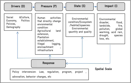
6.1. Driver, Pressure, State, Impact & Response (DPSIR) Approach ... 32
6.2. Lanskap Ecological approach (Structure & Function of Landscape) ... 35
6.2.1. Landscape Definition ... 35
6.2.2. Structure and Function of Landscape ... 35
6.2.3. Variable (Index) of Landscape ... 37
VII. CRITERIA, INDICATOR DAN PARAMETER MONITORING ... 40
7.1. Matrix of Criteria, Indicator, & Monitoring Parameters of Biodiversity at Regional Landscape Level ... 40
7.2. Matrix of Criteria, Indicators and Monitoring Parameter of Biodiversity at Habitat Level ... 43
7.4. Monitoring Driver, Pressure & Response ... 45
VIII. PROPOSE PROGRAM PRIORITY... 48
8.1. Policy Assessment ... 48
8.1.1. Biodiversity Conservation Policy Analysis ... 48
8.1.2. Biodiversity Strategy and Action Plan Making for South Sumatera Province ... 48
8.1.3. Strategic Environment Assessment and South Sumatera Spatial Planning ... 49
8.1.4. Parliament Forum Establishment ... 49
8.2. Assessment in Social, Cultural, Economy and Education Program ... 49
A Framework on Biodiversity Indicators and Parameters for Multipurpose Monitoring System in South Sumatera | ix 8.2.2. Conflict Mapping between Community and Wildlife Animal, including Community
Mitigation and Adaptation Efforts ... 50
8.2.3. Assessment of Protection Area Encroachment ... 50
8.2.4. Biodiversity Management Collaboration : Citizen Science and Monitoring Participative System Approach ... 51
8.2.5. Community-Private Partnership Formation ... 51
8.3. Landscape Ecological Assessment ... 51
8.3.1. Structure Landscape Changes and Its Impacts on Biodiversity ... 51
8.3.2. Corrridor Development study that Linked the Fragment of Protection/Conservation Area 51 8.3.3. Habitat Vulnerability on Fire and Oil and Gas Exploitation Accident ... 52
8.3.4. Mapping the Suitability Habitat for Tiger and Elephant ... 52
8.3.5. Environmental Service Assessment with focusing on Provider of Water and Carbon .... 52
8.4. Study in Habitat Level Program... 53
8.4.2. Mapping the Location Distribution for Feed and Salt Area of Priority Wildlife ... 53
8.5. Study in Protected Species/Population ... 53
8.6. Program Database and Information Program ... 53
8.6.1. Database and WEB GIS Management ... 53
8.6.2. The Biodiversity Collaboration Secretariat Establishment ... 53
IX. CLOSING REMARK... 55
A Framework on Biodiversity Indicators and Parameters for Multipurpose Monitoring System in South Sumatera | x
LIST OF FIGURE
Figure 3.1. Distribution of elevation class Sumatera Selatan Province... 8
Figure 3.2. Distribution of Slope of Sumatera Selatan Province ... 9
Figure 3.3. Trend of Deforestation in Sumatera Selatan Province (Sumber: Ditjenplan, dianalisis) ... 12
Figure 3.4. Land cover of South Sumatra Province in (a) 2000 (b) 2003 (c) 2006 (d) 2009 and (e) 2012 ... 14
Figure 4.1. Scheme of the CBD ... 16
Figure 4.2. Scheme of MRV REDD+ Indonesia ... 22
Figure 6.1. DPSIR Concept ... 33
Figure 6.2. Landscape Structure ... 35
Figure 6.3. Difference Resolution (a) Landsat 30 x 30 m), (b) Ikonos (0.67 x 0.67 m) ... 36
Figure 6.4.Conservation Area Structure ... 37
A Framework on Biodiversity Indicators and Parameters for Multipurpose Monitoring System in South Sumatera | xi
LIST OF TABLE
Table 3.1. Forest State Land of Sumatera Selatan Province ... 10
Table 3.2. Forest Cover wit regard to Forest Function in Sumatera Selatan Province ... 11
Tabel 6.1. Kriteria pemilihan indikator keanekaragaman hayati ... 34
Table 6.2. Indikator dan Variabel (Index) pada Fragstat dan Patch Analysis ... 37
Table 7.1. Matrix of Criteria, Indicators & Parameters of Biodiversity Monitoring at Landscape Level ... 41
Table 7.2. Matrix of Criteria, Indicator and Monitoring Parameter of Biodiversity at Habitat Level ... 43
Table 7.3. Matrix of Criteria, Indicator & Parameter of Biodiversity Monitoring at species and genetic levels... 44
Table 7.4. Monitoring of drivers of biodiversity change (Driver and Pressure) ... 45
A Framework on Biodiversity Indicators and Parameters for Multipurpose Monitoring System in South Sumatera | xii
ACRONYN AND ABBREVIATION
AFOLU : Agriculture Forestry Other Land Use AMDAL : Environmental Impact Analysis BAPI : Biodiversity Action Plan for Indonesia BKSDA : Natural Resources Conservation Unit BIOCLIME : Biodiversity and Climate Change
BMKG : Meteorology Climatology and Geophysics Agency BPS : BPS-Statistics Indonesia
CA : Nature Reserve
CBD : Convention on Biological Diversity COP : Conference of the Parties
CPO : Crude Palm Oil
CSR : Corporate Social Responsibility
DPSIR : Driver-Pressure- State-Impact-Response DPRD : Regional People’s Representative Council
EEA : European Environmental Agency
FAO : Food and Agriculture Organization of The United Nations FGD : Focussed Group Disscusion
FPIC : Free, Prior and Informed Consent GMO : Gene Modified Organism
GIZ : The Deutsche Gesellschaft für Internationale Zusammenarbeit GRK : Greenhouse Gas
HTI : Industrial Plant Forest
IBSAP : Indonesian Biodiversity Strategy and Action Plan IUPHHK : Business Permit for Timber Forest Product Utilization KLH : Ministry of the Environment
KLHS : Environmental Strategic Assessment KPA : Nature Conservation Area
KPH : Forest Management Unit KSA : Sanctuary Reserve Area LIPI : Indonesian Intitute of Sciences LSM : Non Government Organization MODEF : Monitoring of Deforestation
A Framework on Biodiversity Indicators and Parameters for Multipurpose Monitoring System in South Sumatera | xiii NALEM : National Level Land-Based Emission Monitoring
NAPEM : National Level Peat Emission Monitoring
NBSAPs : National Biodiversity Strategies and Action Plans NOAA : National Oceanic and Atmospheric Administration
OECD : Organisation for Economic Co-operation and Development PBB : United Nations
PHBM : Forest Community Based Management
PRISAI : Indonesian Safeguard Principle Criteria and Indicator
RAN-GRK : National Action Plan for Greenhouse Gas Emissions Reduction
REDD+ : Reducing Emissions from Deforestation and Forest Degradation including reforestation, fores carbon stock conservation and sustainable management of forest RTRWP/K : Regional (Province/District) Spatial Planning
RTR : Spatial Planning
SALEM : Sub-National Level Land-Based Emission Monitoring SAPEM : Sub-National Level Peat Emission Monitoring SDM : Human Resources
SKPD : Regional Government Management Units SIG : Geography Information Systems
SM : Wildlife Sanctuary TN : National Park
TNKS : Kerinci Seblat National Park TNS : Sembilang National Park TWA : Nature Recreation Park
UNFCCC : United Nations Framework Convention on Climate Change
A Framework on Biodiversity Indicators and Parameters for Multipurpose Monitoring System in South Sumatera | xiv
GLOSARY
AFOLU : Refers to Agriculture, Forestry and Other Land Use is a new term that published in the guideline of IPCC 2006 including LULUCF scheme (Land Use, Land Use Change, and Forestry), by adding agriculture issues
Cancun Agreement
: A set of significant decisions by the international community to address the long-term challenge of climate change collectively and comprehensively over time and to take concrete action for accelerating the global response
CA : A protected area of importance for wildlife, flora, fauna or features of geological or other special interest, which is reserved and managed for conservation and to provide special opportunities for study or research
COP : The highest decisions making unit in an international convention. Each country that has ratified the convention has their delegation in COP. COP held annually or
bi-annually. COP’s agenda consists of monitoring the implementation of the decisions
and law instrument and decisions making to achieve the convention implementation effectively, including institutional and administrative rules
CSR : A management concept that the private company evolve to integrate social and environmental awareness into business operational management and interaction with others stakeholder
Deforestasi : Deforestation is defined as a long-term/permanently land cover changes from forested land to non forested land, including for estate crops, settlement, industrial area, etc. On the annexes of Protocol Kyoto (COP UNFCCC) deforestation refers to forest land use change into other non-forest land use by man. FAO stated that deforestation is forest land use change to others land use or forest cover decreasing below the minimum standard value 10 % for long term. Additionally, FAO set the minimum of tree height (FAO: 5 m in situ) and minimum area (FAO: 0,5 ha) and stated that agriculture is not a dominated land use. Each country has different definition of minimum forest cover, height and area
DPSIR : Drivers-Pressures-States-Impacts-Responses is a causal framework to link the connection of community and environment
A Framework on Biodiversity Indicators and Parameters for Multipurpose Monitoring System in South Sumatera | xv Indikator : The indicator is a measure , generally quantitative , which can be used to describe
and communicate the complex phenomena simply , including trends and progress regularly
KLHS : A set of systematically, holistic and participatory analysis in order to ensure that the principles of sustainable development has become a basic and integrated into regional development or policy, planning and program
Konservasi in-situ
: On-site conservation or the conservation of genetic resources, species, in natural ecosystem
Konservasi ex-situ
: Out-site conservation or the conservation of genetic resources, species, in a artificial ecosystem
KPA : A Nature Conservation area shall be a specific terrestrial or aquatic area whose main function are to serve life support system and preserve diversity of plant and animal species. As well as to provide a sustainable utilization of living resources and their ecosystems
KPH : Forest Management Unit is the smallest management unit which is feasible to maintain efficiently and sustainably
KSA : A Sanctuary Reserve Area shall be a specific terrestrial or aquatic area having specific criteria for preserving biodiversity plant and animal as well as ecosystem, which also serve as life support system
MODEF : An approach for monitoring deforestation by using low satellite resolution (MODIS atau NOAA)
NALEM : A measurement and monitoring system of dry land national emission by using high satellite resolution, usually held in twice a year
NAPEM : A measurement and monitoring system of national peat-land emission directly the field, usually held in twice a year
OECD : An international forum with the aims to promote policy related to the community economy and social welfare over the world
Parameter : A characteristic, image, and measureable factor that can describe a system or an important element to determine or evaluate a project, situation, and trend
A Framework on Biodiversity Indicators and Parameters for Multipurpose Monitoring System in South Sumatera | xvi of natural resources and the enhancement the Human Development Index which is flexible, participatory, and accommodative
PRISAI : A set of instruments to achieve the safeguard condition in REDD mechanism Remote
Sensing
: A method to measure deforestation and forest degradation using tools indirectly e.g. satellite
RAN-GRK : A national working plan guideline in order to mainstream the efforts in reducing greenhouse gas directly and indirectly based on national development target REDD+ : An international agreement to prevent the climate change by giving compensation
mechanism to developing country in protecting the forest
SALEM : A measurement and monitoring system of sub-national dry land emission by using high satellite resolution
SAPEM : A measurement and monitoring system of sub-national peat-land emission directly the field, usually held in twice a year
SM : A protected area, a naturally occurring sanctuary, that provides protection for species from hunting, predation or competition
SKPD : A set of regional management unit both in province and district, that consists of regional secretariat, parliament secretariat, government office and regional technically unit. SKPD is a regional executive implementing agency that collaborating each other to support the regional program achievement
A Framework on Biodiversity Indicators and Parameters for Multipurpose Monitoring System in South Sumatera | 1
I.
INTRODUCTION
1.1.
Background
Indonesia is known as a mega diversity country and the nation attention to the conservation of biological diversity is very high. It is acknowledge in the Law 5 of 1990 on the Conservation of Biodiversity and ecosystem. The foundation of this policy is stated in the Principal Law of the Republic of Indonesia (UUD 1945) and its amendment, Article 33 section 3, in which Natural resources) including forest ecosystem, biodiversity) belong to the country and must be utilized for the wealth of Indonesian people.
The Indonesian government's commitment is also seen when ratifying the Convention on Biological Diversity (CBD) in 1992 at a meeting of the United Nations Conference on Environment and Development (the Rio "Earth Summit") and followed by the assignment of Law No. 5 of 1994 on the Ratification of the United Nations Convention on Biological Diversity. To support the achievement one of the objectives of the CBD, the Law No. 11 in 2013 on the Ratification of the Nagoya Protocol on access to genetic resources and equitable sharing of benefits arising from the balanced and utilization on biodiversity has also been realized. Conservation of biodiversity have been also given special attention in Law No. 41 in 1999 on forestry, in particular specific location has been allocated in the form forest nature reserves, forest conservation, and hunting parks. The allocation of space for the protection of essential ecosystem functions (peat ecosystems, freshwater swamp ecosystem and other protected areas) are also mandated in the Act No. 26 in 2007 on the National Spatial Planning.
In an effort to protect biodiversity and habitat loss and at the same time reducing greenhouse gas emissions (GHG) emissions as global climate change mitigation efforts, the Government of Indonesia has committed to implement the scheme Reducing Emissions from Deforestation and Forest Degradation (REDD+), through avoiding deforestation, reforestation, conservation of forest carbon stock, and sustainable forest management. In order to prevent negative affect in the implementation of REDD+, the government has set Principles, Criteria and Indicators Safeguard for Indonesia (PRISAI). The PRISAI contains 10 principles, adopted from the 7 principles of the safeguards of the Cancun Agreement, which was agreed at a meeting of the parties to the 16 (COP16) of the United Nations Framework Convention on Climate Change / UNFCCC in 2012 in Mexico. Principle 6th of PRISAI is
supporting biodiversity, protection of natural forests and environmental services.
A Framework on Biodiversity Indicators and Parameters for Multipurpose Monitoring System in South Sumatera | 2 logging, forest fires, and others. This activity causes the loss, degradation and fragmentation of habitats, which encourages the extinction of endemic species of Sumatra, including orangutans, Sumatran tigers, and Sumatran elephants.
In order to protect and conserve habitat and biodiversity, the parties have agreed to set up strategic plan to protect the ecosystem until 2020, which was formulated at COP 10 of the Convention on Biological Diversity (CBD) in Nagoya, Japan. The plan called the Aichi Target, which contains 20 targets, divide into 5 strategic objectives, namely: (a) Mainstreaming biodiversity in government institutions and society as efforts to suppress loss of biodiversity), (b) Reducing the pressure on biodiversity and promote sustainable use , (c) improving the status of biodiversity by protecting its ecosystems, species and genetic diversity, (d) increase the biodiversity benefits and services and (e) improving implementation through participatory planning and capacity building.
Fulfillment of Aichi targets in line with the mandate of Indonesian Forestry Law, National Spatial Planning Law and REDD + safeguards. The achievement of the Aichi target requires data and information about the current state of biological diversity as a base line. So it is very urgent to develop a set of indicators and parameters of biodiversity, which is used to monitor periodically the trend of changes of habitat and biodiversity. Local government (province) has a mandate to do most matters relating to the environment and forestry, as outlined in the Act No. 23 in 2014 on Regional Government and Law No.33 in 2004 on Financial Balance between Central and Local Government, and Law no. 41 of Forestry. One of them is to describe the Indonesian Biodiversity Strategy and Action Plan (IBSAP) into strategic programs at the provincial level.
To achieve this goal, GIZ through the Biodiversity and Climate Change (BIOCLIME) will assist the Government of Indonesia to design and implement legal, policy and institutional reforms for biodiversity conservation and sustainable forest management at the local and provincial level in South Sumatra Province. This program not only contributes to the achievement of biodiversity in Indonesia according to the CBD, but also to meet the target of climate change mitigation and adaptation set UNFCCC to reduce greenhouse gas emissions by 2020. In the early stages, GIZ Bioclime sets up a framework (framework) biodiversity indicators and parameters, which are used to monitor habitat and biodiversity trends measurable changes that are conducted periodically in South Sumatra.
1.2.
Objective
A Framework on Biodiversity Indicators and Parameters for Multipurpose Monitoring System in South Sumatera | 3
1.3.
Activities
a) Identify the necessary activity/program at national and provincial levels for monitoring and reporting of biodiversity
b) Defining the contents of the strategy and action plan for biodiversity at the national and sub-national (provincial)
c) Defining measures, methods and techniques for monitoring biodiversity in South Sumatra d) Identify the likely source of data for monitoring biodiversity in South Sumatra
e) Designing matrix biodiversity monitoring for forest ecosystems including participatory monitoring (which includes the scope, indicators, measurement, data sources, techniques and equipment)
A Framework on Biodiversity Indicators and Parameters for Multipurpose Monitoring System in South Sumatera | 4
II.
METHOD
2.1.
Development Process
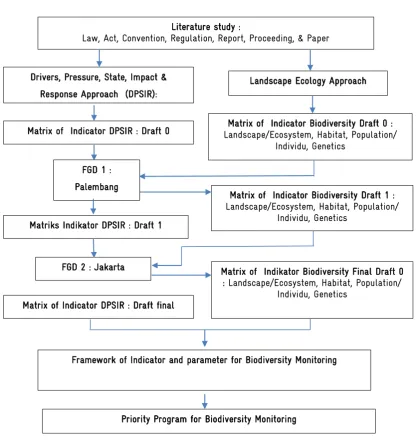
The development of document on framework of indicators and parameters of biodiversity monitoring is participative through Focused Group Discussion / FGD. The process begins with the study of literature from a variety of sources including international conventions, regulations, books, reports, papers/ scientific papers published in journals to determine the framework approach (approach) (Figure 2.1).
Figure 2.1. Flowchart the development of Framework of Indicator and parameter for Biodiversity Monitoring
Matriks Indikator DPSIR : Draft 1
Literature study :
Law, Act, Convention, Regulation, Report, Proceeding, & Paper
Drivers, Pressure, State, Impact & Response Approach (DPSIR):
Landscape Ecology Approach
Matrix of Indicator Biodiversity Draft 0 : Landscape/Ecosystem, Habitat, Population/
Individu, Genetics Matrix of Indicator DPSIR : Draft 0
FGD 1 : Palembang
Matrix of Indicator Biodiversity Draft 1 : Landscape/Ecosystem, Habitat, Population/
Individu, Genetics
Matrix of Indikator Biodiversity Final Draft 0 : Landscape/Ecosystem, Habitat, Population/
Individu, Genetics Matrix of Indicator DPSIR : Draft final
FGD 2 : Jakarta
Priority Program for Biodiversity Monitoring
A Framework on Biodiversity Indicators and Parameters for Multipurpose Monitoring System in South Sumatera | 5 From the above process two approaches was produced, namely Landscape Ecology (Landscape Ecology) and Drivers, Pressure, State, Impact and Response (DPSIR) approach. Based on these two approaches Draft 0 matrix of indicators and parameters of biodiversity monitoring was constructed. The next process was to collect input from relevant institutions (stakeholders) such as NGOs, private sector, and the Local Government Unit / SKPDs through FGD 1st at provincial level (in Palembang).
Based on the first FGD, the Draft 0 was refined into Draft 1 and it was presented in the second FGD in Jakarta to be reviewed by participants from universities, researchers from the Indonesian Institute of Sciences / LIPI), the Ministry of Forestry, and Non-Governmental Organization (NGO). The revised Draft 1 (Final Draft) was used as an input for priority program development.
2.2.
Report Structure
A Framework on Biodiversity Indicators and Parameters for Multipurpose Monitoring System in South Sumatera | 6
REPORT PART 1
III. Environmental Condition of South Sumatera Provinces
IV. Biodiversity Conservation and Its Context with Legislation and Convention
V. Definition of Content Sub-National Biodiversity Strategy and Action Plans based
A Framework on Biodiversity Indicators and Parameters for Multipurpose Monitoring System in South Sumatera | 7
III.
ENVIRONMENTAL CONDITION OF SOUTH SUMATERA
3.1.
Geographics Condition
South Sumatra is one of the ten provinces in Sumatra island, located between 1 ° -4 ° south latitude and 102 ° -106 ° East Longitude (BPS Sumsel 2014). Administratively, the Province adjacent with the province of Jambi province in the north, the province of Lampung in the south, the province of Bangka Belitung in the east and Bengkulu province in the west. Most areas in South Sumatra Province are located in the lowlands, in which many rivers flowing, consisted 54 main river, 287 sub-rivers, 908 sub-sub rivers and 1,723 branches of the river (www.sumselprov.go.id) (MOE 2012).
3.2.
Climate
South Sumatra province has a wet climate and situated at the boundary between the monsoonal pattern that is characterized by a single peak periods of rain and equatorial pattern characterized by two peak periods of rain (MOE 2012). In 2013, BPS South Sumatra (2014) reported an average rainfall reached 281.7 mm, the average air temperature between 26-27oC, the intensity of rainfall between 86 mm-613 mm, and the number of rainy days reached 238 days. Driest days in July while the wettest day in January.
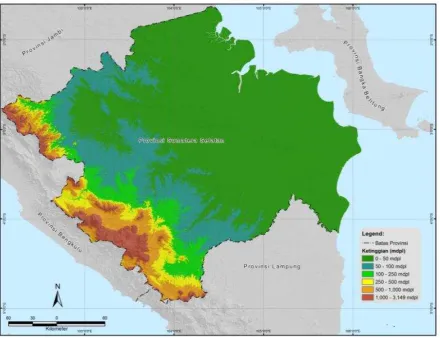
3.3.
Topography
A Framework on Biodiversity Indicators and Parameters for Multipurpose Monitoring System in South Sumatera | 8 Figure 3.1. Distribution of elevation class Sumatera Selatan Province
3.4.
Area and Its Status
Based on the Provincial Spatial Plan in 1994 (RTRWP), total area of South Sumatra Province about 10.9254 million hectares, of which one third is forest area (4,255,843 ha). Based on the Decree of the Minister of Forestry 76 / Kpts-II / 2001 dated March 15, 2001, the forest area in South Sumatra province is 4 416 837 hectares, meanwhile the area of forest state land area reached 4,399,837 hectares. However, area of state forest area has undergone a change. Based on the up dated designation of forest area map in 2012, the state forest area of South Sumatra Province of about 3 670 957 hectares (Alikodra et al. 2013). Detail classification of state forest land are as follows: 1. Forest Conservation (NAC / KSA): 792 907 ha
a) Wildlife: 267 772 ha b) National Parks: 466 060 ha c) Natural Park: 223 Ha d) Forest Park: 607 Ha
A Framework on Biodiversity Indicators and Parameters for Multipurpose Monitoring System in South Sumatera | 9 2. Protection Forest : 591 832 ha
3. Production Forests: 2,286,218 ha
a) Limited Production Forest: 236 893 ha b) Permanent Production Forests: 1,688,445 ha c) Convertible forest: 360 881 ha
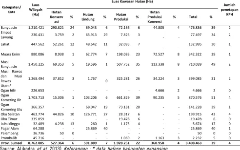
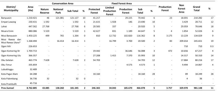
Overall, the largest forest area is located in the district Banyuasin (39%) (Table 3.1).
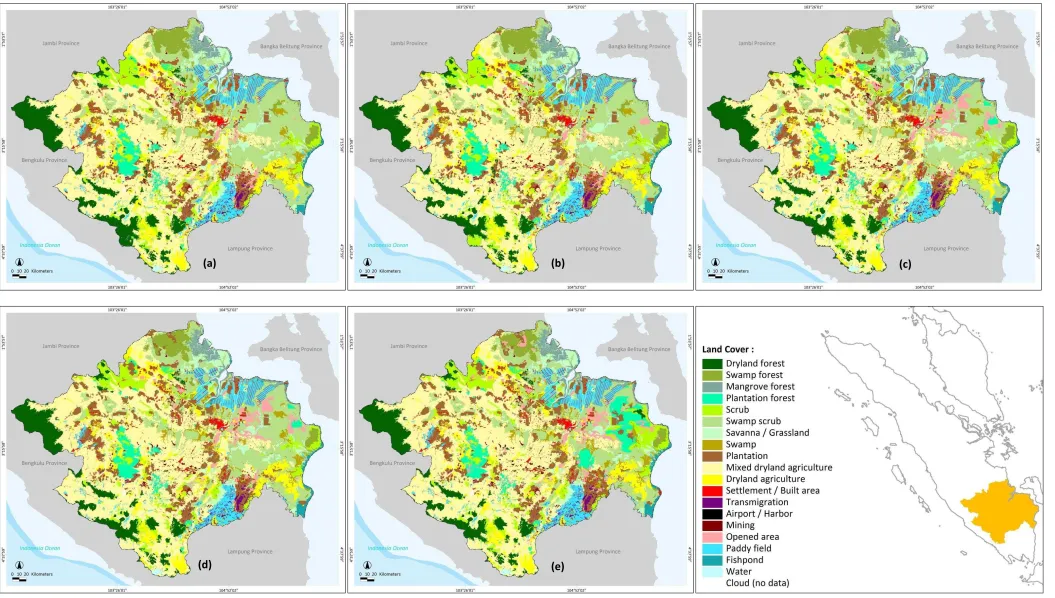
After the island of Java, Sumatra's forests has undergone high pressure from a variety of pressure including the expansion of agricultural land and plantations, unsustainable forest exploitation, mining exploitation, illegal logging, transmigration, and population growth (Damayanti, et al. 2015) . This causes a low percentage of forest cover, which is only 11% (Table 3.2). In 2000, there were approximately 1.06 million ha of natural forest and in 2012 fell to 0.942 million ha, or a decrease of about 9,780 ha per year. The decline is more common in swamp forest, while the upland and mangrove forests are relatively fixed, especially since 2009. In contrast since 2009, plantation area has increased quite large (Figure 3.3). Spatial distribution is presented in Figure 3.4.
A Framework on Biodiversity Indicators and Parameters for Multipurpose Monitoring System in South Sumatera | 10 Table 3.1. Forest State Land of Sumatera Selatan Province
Kabupaten/ Kota
Luas Wilayah
(Ha)
Luas Kawasan Hutan (Ha)
Jumlah penetapan KPH Hutan Konserv asi
% Hutan
Lindung %
Hutan Produksi %
Hutan Produksi Konversi
% Total %
Banyuasin 1.210.421 290.821 24 69.043 6 72.166 6 44.805 4 476.836 39 2 Empat
Lawang 230.431 3.759 2 65.913 29 7.825 3 - - 77.497 34 2 Lahat 447.562 52.261 12 48.642 11 32.093 7
- - 132.995 30 1
Muara Enim 880.086 8.938 1 62.774 7 198.083 23 72.527 8 342.322 39 1
Musi
Banyuasin 1.450.225 69.353 5 19.596 1 507.752 35 113.338 8 710.039 49 2 Musi Rawas
dan Musi Rawas Utara*
1.268.494 37.812 3 1.767
0 325.281 26 34.224 3 399.085 31 2
Ogan hilir 226.653 - - - 4.666 2 4.666 2 0
Ogan
Komering Ilir 1.703.713 15.306 1 103.206 6 661.829 39 90.235 5 870.576 51 4 Ogan
Komering Ulu 366.357 - - 68.047 19 73.181 20 - - 141.228 39 1 Oku Selatan 463.774 44.826 10 126.771 27 28.317 6 - - 199.915 43 4
Oku Timur 335.859 - - - - 19.478 6 - - 19.478 6 0
Lubuklinggu 32.489 4.238 13 260 1 1.175 4 - - 5.674 17 0
Pagar Alam 64.288 - - 25.869 40 - - - - 25.869 40 1
Palembang 36.736 50 0 - - - 50 0 0
Prambulih 45.716 - - - - 1.069 2 1.163 3 2.232 5 0
Prov. Sumsel 8.762.805 527.364 6 591.889 7 1.928.251 22 360.958 4 3.408.463 39 4 (Source: Alikodra et al. 2013) Keterangan : * data before kabupaten expansion
A Framework on Biodiversity Indicators and Parameters for Multipurpose Monitoring System in South Sumatera | 11 Table 3.2. Forest Cover with regard to Forest Function in Sumatera Selatan Province
District/ Municipality
Area (Ha)
Conservation Area Fixed Forest Area
Production Forest
Non Forest
Area
Grand
Total %
Nature Reserve
National
Park Sub Total %
Protected Forest
Limited Production
Forest
Production Forest
Sub
Total %
Banyuasin 1.210.421 46 121.081 121.127 10 41.217 - 29.225 70.442 6 23 18.691 210.282 17 Empat Lawang 230.431 1.592 - 1.592 1 21.615 1.928 146 23.690 10 - 3.429 28.711 12
Lahat 447.562 27.768 - 27.768 6 20.583 337 - 20.920 5 - 29.959 78.646 18
Muara Enim 880.086 5.520 - 5.520 1 42.627 831 1.189 44.647 5 4 1.854 52.026 6
Musi Banyuasin 1.450.225 499 765 1.264 0 810 12.732 102.820 116.362 8 3.175 13.229 134.029 9 Musi Rawas dan
Musi Rawas Utara* 1.268.494 - 16.414 16.414 1 - 16.799 3.700 20.500 2 83 209.654 245.651 19
Ogan hilir 226.653 - - - 710 710 0.3
Ogan Komering Ilir 1.703.713 - - - - 19.442 - 36.646 56.088 3 472 10.656 67.217 4
Ogan Komering Ulu 366.357 - - - - 27.208 1.415 7.370 35.993 10 - 14.317 50.310 14
Oku Selatan 463.774 7.628 - 7.628 2 54.703 - - 54.703 12 - 17.884 80.216 17
Oku Timur 335.859 - - - 4.573 4.573 1 - 9.494 14.067 4
Lubuklinggu 32.489 - - - -
Kota Pagar Alam 64.288 - - - - 18.160 - - 18.160 28 - 89 18.249 28
Kota Palembang 36.736 32 - 32 0 - - - 4 36 -
Kota Prambulih 45.716 - - - -
Prov.Sumsel 8.762.805 43.085 138.260 181.345 2 246.365 34.043 185.670 466.078 5 3.757 329.970 981.148 11
A Framework on Biodiversity Indicators and Parameters for Multipurpose Monitoring System in South Sumatera | 12 Figure 3.3. Trend of Deforestation in Sumatera Selatan Province (Source: Ditjenplan, result from
analysis)
3.5.
Critical Land
MoF (2013) reported in 2007, total area of critical land in South Sumatra was 2,824,849 ha, consisting of critical land area of 2,085,364 ha and very critical land area of 739,485 ha. The area of critical land increased significantly in 2011, which reached to 3,668,355 ha, fortunately, the area of very critical land decreased to 217 707 ha.
3.6.
Ecosystem Biodiversity
A Framework on Biodiversity Indicators and Parameters for Multipurpose Monitoring System in South Sumatera | 13
3.7.
Biodiversity
South Sumatra is home to unique species and high conservation value (MoF 2013). Forest ecosystems in TNKS is home to 4,000 plant species, 350 bird species, and 144 mammal species, including some mammals with rare status (endangered) such as the Sumatran tiger (Panthera tigris sumatrae), Sumatra Asian elephant (Elephas maximus sumatranus), rabbit Sumatra (Nesolagus netscheri), small Sumatran rhino (Dicerorhinus sumatrensis), clouded leopard (Neofelis nebulosa), and Malayan tapir
(Tapirus indicus).
Wetlands and mangrove ecosystems is habitat for many species of water birds including migratory birds (Siberian migrant bird), birds dowitcher Asia (Limnodromus semipalmatus), birds Greenshank
(Pseudototanus guttifer), eastern white bird pelican (Pelecanus onocrotalus), milky stork (Mycteria
cinerea), heron lesser adjutant (Leptoptilos javanicus), black and white bird-winged tern (Chlidonias
leucoptera). In addition there is also a saltwater crocodile (Crocodylus porosus), freshwater dolphins
(Orcaella brevirostris), the giant freshwater turtle (Chitra indica), gibbon (Hylobates syndactylus
syndactylus), golden cat (Catopuma temminckii temminckii), Sambar deer (Cervus unicolor equinus),
bears (Helarctos malayanus), Sumatran tiger (Panthera tigris sumatrae), Sumatra Asian elephant
(Elephas maximus sumatranus), Malayan tapir (Tapirus indicus), and 249 species of fish include fish
Sembilang (Plotusus canius) which is a fish endemic in South Sumatra and fish belida (Chitala lopis) which is also used as the logo of the province. As for vegetation, a wide variety of terrestrial and aquatic plant life in wetlands include nail elephant (Acrostichum aureum), palm (Nypa fruticans), Sea pine (Casuarina equisetifolia), pandan (Pandanus tectorius), sea hibiscus (Hibiscus tiliaceus), nibung
(Oncosperma tigillaria), jelutung (Jelutong), Kempas (Koompassia excelsa), Gelam (Syzygium
A Framework on Biodiversity Indicators and Parameters for Multipurpose Monitoring System in South Sumatera | 14 Figure 3.4. Land cover of South Sumatra Province in (a) 2000 (b) 2003 (c) 2006 (d) 2009 and (e) 2012
(a)
(b)
(c)
A Framework on Biodiversity Indicators and Parameters for Multipurpose Monitoring System in South Sumatera | 15
IV.
BIODIVERSITY CONSERVATION AND ITS CONTEXT WITH LEGISLATION AND
CONVENTION
The context of biodiversity conservation with laws and conventions need to be understood. This is important because the participation of state in signing the convention and its ratification in form of laws lead to consequences that must be implemented, so that things that should be done either at the national or provincial levels can be identified. Several important conventions/protocols include Convention on Biodiversity/CBD, Nagoya Protocol, Aichi Biodiversity Targets, Ramsar Convention and Reducing Emissions from Deforestation and Forest Degradation/REDD).
4.1.
Convention on Biodiversity (CBD)
Convention on Biological Diversity (CBD) was signed by 150 leaders of countries in 1992 at the United Nations Conference on Environment and Development (the Rio "Earth Summit"). Indonesia has ratified the CBD and defined by Act No. 5 of 1994 on the Ratification of the United Nations Convention on Biological Diversity. CBD is a world community’s recognition of the value of biodiversity and its function in the process of evolution and its function in maintaining the life support system on earth. The ratification of the CBD is also caused by the important role of biodiversity in socio-economic and culture of people as well as concerns over the growing amount of pressure on habitats and biodiversity, which triggered the extinction of species.
A Framework on Biodiversity Indicators and Parameters for Multipurpose Monitoring System in South Sumatera | 16 Figure 4.1. Scheme of the CBD
4.1.1.
In-situ dan Ex-situ Conservation
In achieving the conservation goal, the CBD emphasizes the importance of in-situ and ex-situ conservation (Article 8 and Article 9), through a variety of programs including: (a) establishing a network of conservation/protected areas; (b) creating guidelines for development and management of protected areas; (c) managing important biological resources for conservation of biodiversity both inside and outside conservation areas; (d) promoting conservation/protection of ecosystems, natural habitats and maintain viable populations of species in their natural environment; (e) promoting environmentally friendly and sustainable development around conservation/protected areas; (f) conducting rehabilitation and restoration of degraded ecosystems and promoting recovery of threatened species; (g) preparing regulations to control the risk factors of the use and release of genetically modified organisms (GMOs), which can create negative impact on biodiversity, including risk to human health; (h) preventing the introduction of, controlling or eliminating invasive alien
CBD Objectives (Article 1)
a. Conservation of
biodiversity,
b. Sustainable use of its
components, and
c. Fair and balance
distribution of benefits arising from utilization of genetic resources, including to ensure access to genetic resources and the transfer of its technology, and the funding.
In and Ex-situ conservation
(Articles 8 & 9)
Basic data and
Information of
biodiversity, as basis of monitoring
(Article 7)
Sustainable Use
Supporting programs: a. Incentive (Article 11)
b. Research and training
(Article 12)
c. Community education
and awareness (Article 13)
d. Environmental impact
assessment (Article 14)
e. Technical and
research cooperation (Article 18)
f. Funding source
(Article 20) a. Distribution of
benefits (Article 19) + Nagoya Protocol
b. Access to information
& Technology (Article 16)
Preparation of
NBSAP/Strategic Plan (Article 6)
& periodic
reporting (Article 26) Access & distribution of
benefits
A Framework on Biodiversity Indicators and Parameters for Multipurpose Monitoring System in South Sumatera | 17 species which threaten ecosystems, habitats or species; (i) make every effort to harmonize the use and conservation of biological diversity and the sustainable use of its components; (j) to respect, preserve and maintain knowledge, innovations and practices in ways of life of indigenous people and local communities which are in harmony with conservation and sustainable use of biodiversity; (k) to establish/maintain laws/regulations that protect threatened species/populations; (l) managing activities that affect biodiversity; (m) provide funding and other supports for the realization of the above mentioned activities. In in situ conservation, area managers are expected to perform initial identification of components of biodiversity as well as the processes and activities and also conducting periodic monitoring related to the dynamics of changes in habitat/population (Article 7).
As of ex-situ conservation (Article 9), it is advisable to: (a) adopt different ways of ex-situ
conservation; (b) establish and maintain facilities for ex-situ conservation and conduct research on flora, fauna, and micro-organisms; (c) adopt methods to implement the recovery and rehabilitation of threatened species, to be reintroduced to their natural habitats, (d) regulate and manage collection of biological diversity derived from natural habitats for ex-situ conservation purposes; (e) provide funding to support the ex-situ conservatio x-situ.
4.1.2.
Sustainable utilization
In order to make use of biodiversity sustainably, efforts which are feasible economically and socially are obliged to be adopted as incentives for the conservation and sustainable use (Article 11). Research and training (Article 12) shall also be carried out by: (a) establishing and maintaining education and training program, both scientifically and technically, (b) promoting and encouraging research that contributes to the conservation and sustainable use of biodiversity, and (c) promoting and cooperating in the use of scientific advances in biological diversity research in developing methods for conservation and sustainable use of biological resources.
The results of research and training need to be promoted through community education and awareness programs (article 13) through: (a) promoting understanding of the importance of biodiversity conservation and propagation, either through the media or integrating it in educational programs, and (b) cooperating with other countries as well as international organizations in developing educational and public awareness programs.
A Framework on Biodiversity Indicators and Parameters for Multipurpose Monitoring System in South Sumatera | 18 Sources of funding for implementation of the CBD (Article 20) should be pursued by each country in accordance with their own capabilities, plans, priorities, and national programs. In this regard, developed countries are obliged to assist developing countries in forms of source of funding as well as technology transfer.
4.1.3.
Access arrangements, transfer of technology, patent and benefit sharing
Warranty of access and equitable benefit-sharing on sustainable use of biodiversity are also mandated (Articles 16 and 19), by undertaking legislative, administrative, and policy efforts, so that the village/ forest communities that have been interacting and using biodiversity for in their daily lives since long ago, both for the fulfillment of food, medicine, housing and clothing, are treated fairly. It is further described in section 2.2 of Nagoya Agreement.
4.1.4.
National Biodiversity Strategies and Action Plans/NBSAPs)
NBSAPs or equivalent instruments are instruments used for implementation of the CBD at national level. NBSAPs are plans and strategies to achieve objectives of biodiversity conservation through integration of sustainable use of biodiversity into the programs in all sectors, such as that mandated in Article 6 of the CBD and reported periodically (Article 26).
NBSAP Indonesia or better known as Indonesian Biodiversity Strategies and Action Plans (IBSAP) was first created in 1993 with the name of the Biodiversity Action Plan for Indonesia (BAPI), and then updated in 2003 for the period of up to 2020. IBSAP of 2003 to 2020 period has gone through changes associated with changes in biodiversity management paradigm with more emphasize on participation and transparency.
The main purpose of IBSAP 2003-2020 is to facilitate the activities of conservation and sustainable use of biodiversity as has been stated in the CBD. The specific objectives of IBSAP 2003-2020 are as follows: (a) assessing the needs and priorities of action as mentioned in the BAPI 1993, identifying what has been achieved, what could not been done, and find out why the needed funds and/or motivation have not yet been obtained.(b) to identify new needs and priority actions and revise plans of action based on potential changes in environmental policy at this time or in the future; (c) to identify existing opportunities and constraints for effective conservation and sustainable use of biodiversity, including gaps in existing knowledge, as well as setting targets and realistic actions to address these gaps; and (d) to prepare a new and clear strategy with a more detailed plan of action.
4.1.5.
Next Step of CBD
A Framework on Biodiversity Indicators and Parameters for Multipurpose Monitoring System in South Sumatera | 19 (a) Formulation of Strategy and Action Plan on Biological Diversity at provincial level (Provincial
Biodiversity Strategy and Action Plan)
(b) Identification/recording of the wisdom of traditional community (c) Identification of the status of biodiversity of flora and fauna (d) The preparation of biodiversity indicators for monitoring purposes. (e) Develop a database of biodiversity
(f) Conducting a program of mainstreaming of biodiversity conservation in various sectors.
4.2.
The Nagoya Protocol
The Nagoya Protocol is a supplementary agreement to the CBD that provide legal and transparent framework for the implementation of the three objectives of the CBD, namely the distribution of the fair and equitable benefits arising from the utilization of genetic resources, including assurance of access to genetic resources and transfer of its technology, by taking into account all rights over the resources and technology, and the funding. The Nagoya Protocol is an elaboration of Article 15 and Article 19 of the CBD.
The Nagoya Protocol will create certainty and transparency for both parties, namely the providers and users of genetic resources, by (a) making access to genetic resources more predictable and (b) help ensure the sharing of benefits when genetic resources leave the country of origin of the genetic resource provider. Nagoya Protocol applies to genetic resources covered by the CBD and the distribution of benefits on their utilization, including traditional knowledge associated with genetic resources contained in the CBD and the benefits arising from their utilization.
There are three obligations under the Nagoya Protocol that should be adhered to:
A Framework on Biodiversity Indicators and Parameters for Multipurpose Monitoring System in South Sumatera | 20 profits/benefits can be in forms of financial and non-financial, such as royalties and dissemination of information on research results.
3) The obligation of compliance. Some special obligations that support compliance with domestic legislation or regulatory requirements of providers of genetic resources and contractual obligations reflected in the terms that have been agreed on represent significant innovations of the Nagoya Protocol. The parties are obliged to: (a) take measures which the utilization of genetic resources within their jurisdiction has been accessed in accordance with the approval of initial information (FPIC-) and the terms that have been agreed upon have been made, and in accordance with the request of other parties; (b) cooperate in cases of alleged infringement of other party; (c) encourage the terms of contract on dispute resolution in the terms that have been agreed on; (d) ensure an opportunity is available to look for other alternatives in the legal system when a dispute occurs; (e) take measures of access to justice; (f) take measures to monitor the utilization of genetic resources after leaving a country, including through the creation of effective checkpoints at every stage of the value chain: research, development, innovation, pre-commercialization and commercialization.
4.3.
National Biodiversity Strategies and Action Plans (NBSAPs)
At COP 9 in 2008 in Bonn, Germany it was agreed that there is a necessity for a revision of the strategic plan of 2003-2020. The revision was approved at COP 10 in Aichi Prefecture, Nagoya-Japan by submitting Aichi Biodiversity Targets for the period 2011-2020 (decision X/2 on the Strategic Plan for Biodiversity 2011-2020). This is a lesson learned) from the implementation of the strategic plan which was not achieved in 2010.
Aichi Target has 20 targets, which are grouped into 5 strategies 5 achievement, namely:
a. Strategic Objective A. Addressing underlying causes/Drivers of the loss of biodiversity by means of mainstreaming biodiversity in government and society.
b. Strategic Goal B. Reducing direct pressures on biodiversity and promoting sustainable use c. Strategic Objective C: Improving the status of biodiversity through safeguards to the
ecosystem, species and genetic diversity.
d. Strategic Goal D: Enhance the benefits of all forms of diversity and environmental services e. Strategic Goal E. Enhance implementation of biodiversity conservation program through
participatory planning, knowledge management and capacity building.
A Framework on Biodiversity Indicators and Parameters for Multipurpose Monitoring System in South Sumatera | 21
4.4.
RAMSAR Convention
The International Convention on the Conservation of Wetlands and Waterfowl/Ramsar, Iran 1971) or the Ramsar Convention is an agreement among countries that are committed to conserve important ecological characteristics of international wetlands especially that serve as habitats for water birds and to plan the utilization wisely and sustainably. This convention is not affiliated with any agreements between countries under the United Nations. The mission of this convention is the conservation and use of wetlands through local and national actions through international cooperation as a contribution to achieving sustainable development throughout the world.
At this convention the position of South Sumatra Province was very important because Sembilang National Park was one of Indonesia's wetlands which was registered in the Ramsar Convention, in addition to Berbak National Park (Jambi), Sentarum Lake National Park (West Kalimantan), Pulau Rambut Wildlife Reserve (Jakarta), Rawa Opa Watumohai National Park (South Sulawesi), Tanjung Puting National Park (Central Kalimantan), and Wasur National Park (Papua). This required the local government of South Sumatra conducted various programs to reduce pressures (Drivers & Pressure) in addition to finding efforts to utilize it in a sustainable manner.
4.5.
Biodiversity Conservation in the Context of MRV REDD +
Reducing Emissions from Deforestation and Forest Degradation including reforestation, forest carbon stock conservation and sustainable management of forest/REDD+ is one of the mechanisms to mitigate global climate change by means of reducing greenhouse gas emissions from deforestation and forest degradation, conservation of forest carbon stocks and peat lands, sustainable forest management, and enhance forest carbon stocks. REDD+ scheme was proposed by Papua New Guinea and Costa Rica at the Conference of the Parties /COP 11 in Montreal in 2005, which was later adopted at COP 13 (FCCC/CP/ 2007/6/Add./2/CP. 13) and was recognized in Copenhagen Agreement (Copenhagen Accord) at COP 15 (FCCC/CP/2009/11/Add.1/4/CP.15).
In addition to REDD+ other mitigation measures that have been implemented by Indonesia at national level is the National Action Plan for Greenhouse Gas Emission Reduction (RAN-GRK) which is regulated by Presidential Decree 61/2011. In RAN-GRK, the REDD+ is grouped as effort to reduce emissions from the forestry sector (Agriculture, Forestry, and Other Land Use/AFOLU). Indonesia's emissions reduction target in 2020 is 26% of the scenario of Business As Usual (BAU) on the country’s own efforts and
41% with the cooperation of international community (President's speech at the G20 forum in Pittsburgh-Pennsylvania USA, on September 25, 2009). Periodically, each country reported its GHG emissions to the United Nations Framework Convention on Climate Change (UNFCCC).
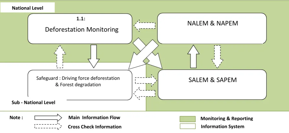
A Framework on Biodiversity Indicators and Parameters for Multipurpose Monitoring System in South Sumatera | 22 Plan at COP 13 in 2007 (1/CP.13 paragraph 1 (b) (ii)), the Cancun agreement at COP 16 in 2010 (add 1/C/ Par.70, 1/CP.16 par 61, par 62 and par 71), and the conclusion at SBSTA 36 in Bonn in 2012. Indonesia has designed the MRV structure as shown in Figure 4.2.
At national level there are two monitoring activities, namely Measurement and Monitoring of Deforestation (MODEF) and National Emission Measurement and Monitoring, which can be divided into peatland emissions (National Level Peat Emission Monitoring (NAPEM) and non-peat (National Level Land- based Emission Monitoring (NALEM). In MODEF monitoring of deforestation is conducted near real time per month by using low resolution satellite data (Moderate-Resolution Imaging Spectroradiometer/MODIS or the National Oceanic and Atmospheric Administration/NOAA).
The objective of MODEF is to obtain information on deforestation as early as possible, so that appropriate action can be taken. NALEM and NAPEM are conducted every two years. NALEM uses high-resolution satellite data, while NAPEM is done by direct measurement in the field. At the sub-national level there are also emissions measurements on dry land (SALEM) and peat (SAPEM). In the scheme of MRV REDD+ the biodiversity monitoring is placed on Safeguard Framework Information Systems. The monitoring of biodiversity is conducted biennially.
[image:39.595.75.566.374.600.2]Figure 4.2. Scheme of MRV REDD+ Indonesia
Security Framework principles have been agreed in the Cancun Agreements (Cancun Agreement) at COP 16 (FCCC / CP / 2010/7 / Add.1 / C / App.I / Par.2), namely:
a. The conducted activities are consistent with the objectives of national forest programs, conventions, and related international agreements.
b. The structure of national forest governance that is transparent and effective, considering the applicable provisions of law and the sovereignty of the country concerned.
National Level
Deforestation Monitoring
NALEM & NAPEM
Safeguard : Driving force deforestation
& Forest degradation
SALEM & SAPEM
Sub - National Level
Note : Main Information Flow
Cross Check Information
A Framework on Biodiversity Indicators and Parameters for Multipurpose Monitoring System in South Sumatera | 23 c. Respect for the knowledge and rights of indigenous peoples and local communities, taking
into account national responsibilities, conditions and law.
d. Full and effective participation of the parties, especially indigenous and local communities. e. Consistent with the conservation of natural forests and biodiversity, and be able to provide
incentives for the protection and conservation of natural forests and ecosystem services, as well as to improve social and other environmental benefits.
f. Actions to address reversals.
g. Action to reduce emissions diversion.
For implementation, Indonesia has built Principles, Criteria, and Indicators of Safeguards Indonesia (PRISAI) containing 10 principles which are developed from the 7 safeguard principles above, as follows:
a. Verify the status of rights of the land and territory.
b. Complete or consistent with emission reduction targets, relevant international conventions and agreements.
c. Improving forest governance.
d. Respect and empower knowledge and rights of indigenous people and local communities. e. Full and effective participation of stakeholders and to consider gender equality.
f. Strengthen the conservation of natural forests, biodiversity, and ecosystem services. g. Action to manage reversals.
h. Action to reduce emissions diversion.
i. The benefits of REDD+ are shared equitably to all the rights holders and relevant stakeholders. j. Ensure that information is transparent, accountable and institutionalized.
Based on the Cancun Agreement, biodiversity is contained in the 5th safeguard framework, that is "Consistent with the conservation of natural forests and biodiversity, and is able to provide incentives for the protection and conservation of natural forests and ecosystem services, as well as to improve the social and other environmental benefits". Whereas according to PRISAI, conservation of biodiversity is the 6th principle, namely "to strengthen the conservation of natural forests, biodiversity, and ecosystem services". The principles outlined above are in line with the objective of achieving the Aichi Targets.
A Framework on Biodiversity Indicators and Parameters for Multipurpose Monitoring System in South Sumatera | 25
V.
DEFINITION OF THE CONTENT OF THE SUB NATIONAL BIODIVERSITY
STRATEGY AND ACTION PLAN BASED ON NATIONAL BIODIVERSITY
STRATEGIES AND ACTION PLANS (NBSAPS)
This chapter provides direction and defines the contents of the document of Sub-National Biodiversity Strategy and Action Plan. This document is a derivative of the National Biodiversity Strategy and Action Plan, which consists of at least five main chapters, which is structured as follows.
Chapter I. Description of the document and purpose of its preparation 1.1.Description of the document
1.2.Purpose of the document preparation Chapter II. Present condition of habitats & biodiversity
2.1. Trend of habitat change 2.1.1. Forest Ecosystem
a. Low land forest
b. Swamp and peat forest c. Mangroves
d. Riparian
2.1.2. Agroforestry (Jungle rubber) 2.1.3. Agriculture and plantation 2.2. Biodiversity
2.2.1. Terrestrial Ecosystem 2.2.2. Swamp and Peat Ecosystem 2.2.3. River and Riparian Ecosystem 2.2.4. Coastal and Marine Ecosystem
2.3. Drivers & Pressures of Degradation of Habitat and Species Diversity
2.4. Policy/Program (Response) of regional government for conservation of habitat and species diversity
Chapter III. Biodiversity management strategy and action plan 3.1. Vision & Mission
3.2. Goals
3.3. Biodiversity Conservation Action Plan Chapter IV. Biodiversity Conservation Management Strategy
Chapter V. Implementation Strategy of Biodiversity Conservation Action Plan REFERENCES
A Framework on Biodiversity Indicators and Parameters for Multipurpose Monitoring System in South Sumatera | 26
5.1.
Description of the report and purposes of its preparation (Chapter I)
Chapter I contains a description of the report and the purpose of the preparation of the report. This chapter can be divided into two sub-chapters, namely the description of sub-chapter of description of the document, and sub-chapter of purpose of the document preparation. The description of the document outlining the relationship between the Biodiversity Strategy and Action Plan at Provincial and National levels.
In addition, it is also necessary to be explained the position of this document compares to other regulation and international agreements such as the Convention on Biodiversity (CBD) which has been enacted into Law No. 5, 1994 on the ratification of the United Nations Convention on Biological Diversity, and Law No. 11, 2013 on the ratification of the Nagoya Protocol, namely access to genetic resources and the fair and equitable sharing of benefits arising from their utilization to the convention on biological diversity).
In addition, it should be emphasized the relation between the report and REDD+ which has been agreed at COP 13 in Bali in 2007, where the government has set PRISAI (Principles, Criteria and Indicators Safeguard Indonesia) as a follow up. PRISAI contains 10 principles which were developed from the 7 principles of the safeguards of the Cancun Agreement, which was agreed at the 16th meeting of the parties (COP 16) of the United Nations Framework on Climate Change (UNFCC) in 2012 in Mexico. The 5th principle of PRISAI is Supporting biodiversity, protection of natural forests and environmental services. In the description of the purpose of the preparation of the document it is described briefly the contents of the document chapter by chapter.
5.2.
Present condition of habitat & biodiversity (Chapter II)
Chapter II describes the current condition of habitats and biodiversity. In this chapter there is a need of support of data that is up to date. The data is obtained from secondary data derived from reports of various related parties, government agencies, NGOs or researchers from universities. At the first FGD meeting in Palembang and at the second in Jakarta, important types of habitat that have been identified in South Sumatra Province include peat swamp forests, mangroves, forest lowland, upland forest, agroforestry rubber, agriculture and plantations. In addition, it has been known about some research related to several important species including elephant, Sumatran tiger, crocodile sinyulong, hornbills, and Ulen.
Sub-chapter 2.1 on habitat change can be done by comparing satellite imagery data after spatial classification and analysis by using Geographic Information System (GIS).
A Framework on Biodiversity Indicators and Parameters for Multipurpose Monitoring System in South Sumatera | 27 Forest