Open Geospatial Consortium
Submission Date: 2017-06-14
Approval Date: 2017-08-14
Publication Date: 2017-09-22
External identifier of this OGC® document: <http://www.opengis.net/doc/standard/infragml/part7/1.0>
Internal reference number of this OGC® document: 16-107r2
Version: 1.0
Category: OGC® Encoding Standard
Editor: Paul Scarponcini
Contributors: Erik Stubkjær
OGC InfraGML 1.0: Part 7 – LandInfra Land Division -
Encoding Standard
Copyright notice
Copyright © 2017 Open Geospatial Consortium
To obtain additional rights of use, visit http://www.opengeospatial.org/legal/.
Warning
This document is an OGC Member approved international standard. This document is available on a royalty free, non-discriminatory basis. Recipients of this document are invited to submit, with their comments, notification of any relevant patent rights of which they are aware and to provide supporting documentation.
Document type: OGC® Standard Document subtype:
License Agreement
Permission is hereby granted by the Open Geospatial Consortium, ("Licensor"), free of charge and subject to the terms set forth below, to any person obtaining a copy of this Intellectual Property and any associated documentation, to deal in the Intellectual Property without restriction (except as set forth below), including without limitation the rights to implement, use, copy, modify, merge, publish, distribute, and/or sublicense copies of the Intellectual Property, and to permit persons to whom the Intellectual Property is furnished to do so, provided that all copyright notices on the intellectual property are retained intact and that each person to whom the Intellectual Property is furnished agrees to the terms of this Agreement.
If you modify the Intellectual Property, all copies of the modified Intellectual Property must include, in addition to the above copyright notice, a notice that the Intellectual Property includes modifications that have not been approved or adopted by LICENSOR.
THIS LICENSE IS A COPYRIGHT LICENSE ONLY, AND DOES NOT CONVEY ANY RIGHTS UNDER ANY PATENTS THAT MAY BE IN FORCE ANYWHERE IN THE WORLD.
THE INTELLECTUAL PROPERTY IS PROVIDED "AS IS", WITHOUT WARRANTY OF ANY KIND, EXPRESS OR IMPLIED, INCLUDING BUT NOT LIMITED TO THE WARRANTIES OF MERCHANTABILITY, FITNESS FOR A PARTICULAR PURPOSE, AND NONINFRINGEMENT OF THIRD PARTY RIGHTS. THE COPYRIGHT HOLDER OR HOLDERS INCLUDED IN THIS NOTICE DO NOT WARRANT THAT THE FUNCTIONS CONTAINED IN THE INTELLECTUAL PROPERTY WILL MEET YOUR REQUIREMENTS OR THAT THE OPERATION OF THE INTELLECTUAL PROPERTY WILL BE
UNINTERRUPTED OR ERROR FREE. ANY USE OF THE INTELLECTUAL PROPERTY SHALL BE MADE ENTIRELY AT THE USER’S OWN RISK. IN NO EVENT SHALL THE COPYRIGHT HOLDER OR ANY CONTRIBUTOR OF
INTELLECTUAL PROPERTY RIGHTS TO THE INTELLECTUAL PROPERTY BE LIABLE FOR ANY CLAIM, OR ANY DIRECT, SPECIAL, INDIRECT OR CONSEQUENTIAL DAMAGES, OR ANY DAMAGES WHATSOEVER RESULTING FROM ANY ALLEGED INFRINGEMENT OR ANY LOSS OF USE, DATA OR PROFITS, WHETHER IN AN ACTION OF CONTRACT, NEGLIGENCE OR UNDER ANY OTHER LEGAL THEORY, ARISING OUT OF OR IN CONNECTION WITH THE IMPLEMENTATION, USE, COMMERCIALIZATION OR PERFORMANCE OF THIS INTELLECTUAL PROPERTY.
This license is effective until terminated. You may terminate it at any time by destroying the Intellectual Property together with all copies in any form. The license will also terminate if you fail to comply with any term or condition of this Agreement. Except as provided in the following sentence, no such termination of this license shall require the termination of any third party end-user sublicense to the Intellectual Property which is in force as of the date of notice of such termination. In addition, should the Intellectual Property, or the operation of the Intellectual Property, infringe, or in LICENSOR’s sole opinion be likely to infringe, any patent, copyright, trademark or other right of a third party, you agree that LICENSOR, in its sole discretion, may terminate this license without any compensation or liability to you, your licensees or any other party. You agree upon termination of any kind to destroy or cause to be destroyed the Intellectual Property together with all copies in any form, whether held by you or by any third party.
Contents
1. Scope ... 8
2. Conformance ... 8
3. References ... 9
4. Terms and Definitions ... 9
4.1 Land Division Terms ... 10
5. Conventions ... 10
5.1 Abbreviations ... 10
5.2 UML Package and Class Diagrams ... 10
5.3 Requirements ... 10
6. InfraGML Parts ... 11
7. Requirements Classes for this Part ... 14
7.1 Structural Overview of Requirements Classes ... 14
7.1.1 Requirement Classes Defined in This Part ... 14
7.1.2 Dependent Requirement Classes Defined in Other Parts ... 15
7.1.3 Other Standards upon which the Requirement Classes of this Part Depend 15 7.2 Requirements Class: LandDivision ... 16
7.2.1 Implementation decisions regarding OGC 15-111r1 UML ... 16
7.2.2 Specific Requirements for this Requirements Class ... 16
7.3 Requirements Class: Condominium ... 18
7.3.1 Implementation decisions regarding OGC 15-111r1 UML ... 18
7.3.2 Specific Requirements for this Requirements Class ... 18
8. Media Types for any data encoding(s) ... 19
Annex A: Conformance Class Abstract Test Suite (Normative) ... 20
A.2 Conformance class: Condominium ... 20
Annex B: Sample XML (Informative) ... 21
B. 1 Complete land division and condominium example ... 21
B. 2 Bounding Elements example ... 28
B. 3 Condominium example ... 43
Annex C: Revision history ... 51
Figures
i.
Abstract
This OGC InfraGML Encoding Standard presents the implementation-dependent, GML encoding of concepts supporting land and civil engineering infrastructure facilities specified in the OGC Land and Infrastructure Conceptual Model Standard (LandInfra), OGC 15-111r1. Conceptual model subject areas include land features, facilities, projects, alignment, road, railway, survey (including equipment, observations, and survey results), land division, and condominiums.
InfraGML is published as a multi-part standard. This Part 7 addresses the LandDivision and Condominium Requirements Classes from LandInfra.
ii.
Keywords
The following are keywords to be used by search engines and document catalogues. OGC document, LandInfra, InfraGML, infrastructure, land parcel, real estate, immovable property, condominium, strata title
iii.
Preface
In order to achieve consensus on the concepts supporting land and civil engineering infrastructure facilities, a UML Conceptual Model, LandInfra, was approved as an OGC standard 2nd August, 2016. This model provides a unifying basis for encodings including but not limited to InfraGML, including similar work in buildingSMART International. It can also provide a framework for discussing how other software standards relate to LandInfra.
As an OGC standard, LandInfra follows the OGC modular specification standard, OGC 08-131r3. Because of the breadth of LandInfra, its subject areas are divided into separate Requirements Classes. This InfraGML encoding similarly is divided into Requirements Classes which are then grouped into Parts. A Part may address multiple LandInfra
Requirements Classes but each Requirements Class is addressed in a single part. Because Requirements Classes may depend on other Requirements Classes (see LandInfra Figure 1, “Requirements Classes as UML Packages with their dependencies”), the reader of this InfraGML Part may need to conform to Requirements Classes in other Parts as well. Note that this InfraGML encoding standard is a target of LandInfra and therefore this standard conforms to the Requirements Classes in LandInfra. On the other hand, an application claiming conformance to this InfraGML encoding standard must conform to the Requirements Classes contained in this InfraGML standard.
constraints. And of course, it should be easier for the application software developer to only deal with Parts relevant to their application.
Attention is drawn to the possibility that some of the elements of this document may be the subject of patent rights. The Open Geospatial Consortium shall not be held
responsible for identifying any or all such patent rights.
Recipients of this document are requested to submit, with their comments, notification of any relevant patent claims or other intellectual property rights of which they may be aware that might be infringed by any implementation of the standard set forth in this document, and to provide supporting documentation.
iv.
Submitting organizations
The following organizations submitted this Document to the Open Geospatial Consortium (OGC):
Bentley Systems, Inc.
Aalborg University, Dept. of Development & Planning Trimble Inc.
Leica Geosystems
v.
Submitters
All questions regarding this submission should be directed to the editor or the submitters:
Name Affiliation
Paul Scarponcini, SWG chair Bentley Systems, Inc.
Erik Stubkjær Aalborg University, Dept. of
Development & Planning
Leif Granholm Trimble Inc.
Johnny Jensen Trimble Inc.
Hans-Christoph Gruler, SWG co-chair Leica Geosystems
Orest Halustchak Autodesk
1.
Scope
InfraGML is a GML encoding standard of the LandInfra Conceptual Model standard, OGC 15-111r1. InfraGML is provided as a set of individual though inter-dependent Parts, each of which is a GML standard.
The overall scope of this InfraGML Encoding Standard is infrastructure facilities and the land on which they are constructed. Also included is the surveying necessary for the setting out and as-built recording of these facilities and interests in land. Primarily
having a civil engineering point of view, InfraGML is relevant across all life cycle phases of a facility. Subject areas include land features, facilities, projects, alignment, road, railway, survey (including equipment, observations, and survey results), land division, and condominiums.
The scope of this Part 7of InfraGML addresses the following subject area(s): land division and condominium. These subject areas are commonly termed ‘cadastral survey’, but this term is avoided here, as it includes surveying, which is addressed by Part 6 of InfraGML. Two InfraGML Requirements Classes are included: LandDivision and Condominium. An application can conform to InfraGML without supporting all other parts of InfraGML, for example the Survey Requirements Classes of Part 6. However, to claim support for LandDivision, an application must also support the InfraGML Core and to claim support for Condominium, an application must in addition support the
LandDivision Requirements Class.
2.
Conformance
The InfraGML encoding standard defines requirements, grouped into Requirements Classes, for applications which read and write information about infrastructure facilities and the land on which they are constructed, including the surveying necessary for the setting out and as-built recording of these facilities and land interests.
The OGC modular specification (OGC 08-131r3) defines “standardization target” as the entity to which requirements of a standard apply. It further notes that the standardization target is the entity which may receive a certificate of conformance for a requirements class. The standardization target type for this standard is therefore:
• software applications which read/write data instances, i.e., XML documents that encode land, infrastructure facility, and survey data for exchange.
testing, and the criteria to be achieved to claim conformance are specified in the OGC Compliance Testing Policies and Procedures and the OGC Compliance Testing web site1. In order to conform to this OGC encoding standard, a standardization target shall choose to implement the core conformance class and any of the other conformance classes with their dependencies. Conformance classes are based on Requirements Classes which are specified in this and possibly other Parts of the InfraGML standard.
All requirements classes and conformance classes described in this document are owned by the standard(s) identified. Note that Conformance Classes for this Part of InfraGML may require conformance with Conformance Classes from other Parts of InfraGML.
3.
References
The following normative documents contain provisions that, through reference in this text, constitute provisions of this Part of InfraGML. For dated references, subsequent amendments to, or revisions of, any of these publications do not apply. For undated references, the latest edition of the normative document referred to applies.
OGC 07-036, OpenGIS® Geography Markup Language (GML) Encoding Standard, v3.2.1, August 27, 2007
OGC 10-129r1, OGC® Geography Markup Language (GML) — Extended schemas and encoding rules, v3.3, February 7, 2012
OGC 15-111r1, OGC Land and Infrastructure Conceptual Model Standard (LandInfra), v1.0, August 2nd , 2016.
OGC 16-100, OGC InfraGML 1.0: Part 0 – LandInfra Core – Encoding Standard, v1.0, June, 2017
4.
Terms and Definitions
This document uses the terms defined in Sub-clause 5.3 of [OGC 06-121r8], which is based on the ISO/IEC Directives, Part 2, Rules for the structure and drafting of
International Standards. In particular, the word “shall” (not “must”) is the verb form used to indicate a requirement to be strictly followed to conform to this standard.
The LandInfra standard contains a long list of terms and definitions relevant to the scope of InfraGML. As these will not be repeated here, the reader is directed to Clause 4 of LandInfra. Only terms not already appearing there are listed below.
4.1 Land Division Terms
4.1
cadastral survey
survey of the boundary of an interest in land
Note 1 to entry: Cadastral survey is performed for the initial formation of property units, as well as for re-establishment of missing boundaries and subsequent changes of the boundaries.
Note 2 to entry: Demarcation of boundary with survey monument and documentation in terms of a
statement is covered by this standard, while adjudication (the process leading to determination of rights in land) and registration (the official recording by the pertinent agency) is out of scope.
5.
Conventions
5.1 Abbreviations
In this document the following abbreviations and acronyms are used or introduced: GML Geography Markup Language
ISO International Organization for Standardization OGC Open Geospatial Consortium
UML Unified Modeling Language XML eXtensible Markup Language
5.2 UML Package and Class Diagrams
The LandInfra standard contains UML diagrams for the concepts supported by InfraGML. As these will not be repeated here, the reader is directed to Clause 7 of LandInfra. UML will only appear in InfraGML in the rare cases where LandInfra is extended by InfraGML.
5.3 Requirements
When referred to in a Requirement or Requirements Class, the boxes contained in the LandInfra UML figures may all be called “Classes” even if they are data types, enumerations, code lists, unions etc. In most cases, these will be encoded as XML elements in InfraGML.
When an InfraGML Requirement states that “A conforming application shall support the [Requirements Class] XML elements listed in Table <n> in accordance with the GML XSD in this standard.”, the XSD was developed to support the UML for the
a) all classes shown as blue boxes for the corresponding LandInfra Requirements Class UML diagrams;
b) all attributes, attribute cardinalities, and attribute data types of these classes (usually shown in subsequent diagrams);
c) all associations, navigation, roles, and role cardinalities connected to the blue classes;
d) all classes shown as beige boxes (another Requirements Class) in the diagrams connected to the blue box classes by association or used as attribute data types; and
e) all classes shown as pink boxes (another Standard) in the figure connected to the blue box classes by association or used as attribute data types.
Note that, in rare cases, the OGC 15-111r1 UML may be altered. In such cases, the alterations are declared in the first subclause of each Requirements Class, entitled “Implementation decisions regarding OGC 15-111r1 UML”. Logical Model UML diagrams may be included if the implementation constraints of GML (or XML) dictate that the Conceptual Model cannot be implemented directly as shown in OGC 15-111r1. In most cases, the InfraGML XML derived from the LandInfra UML follows the rules in OGC 07-036, GML, Annex E, UML-to-GML application schema encoding rules.
The only normative version of the GML XSD (XML schema definition) for all Parts of the InfraGML Encoding Standard is available from the official OGC XML schema repository at http://schemas.opengis.net. Any occurrences of all or part of this XSD contained within this document are to be considered to be informative only.
The URI base for the LandInfra Conceptual Model standard is
http://www.opengis.net/spec/landinfra/1.0. All URIs of Requirements Classes,
Requirements, and Conformance Classes contained in that standard are relative to this base.
The URI base for this InfraGML encoding standard is
http://www.opengis.net/infragml/part7/1.0. All URIs of Requirements Classes,
Requirements, and Conformance Classes contained in this standard are relative to this base.
6.
InfraGML Parts
“OGC 16-10n, OGC® InfraGML 1.0: Part n - <part name> Encoding Standard”, where Part numbers and names are as follows:
n <part name> 0 LandInfra Core
1 LandInfra LandFeatures
2 LandInfra Facilities and Projects 3 LandInfra Alignments
4 LandInfra Roads 5 LandInfra Railways 6 LandInfra Survey 7 LandInfra LandDivision
Some InfraGML Parts depend upon other parts:
0. Core
2. Facilities and Projects
6. Survey 7. LandDivision
3. Alignments
4. Roads 5. Railways
1. LandFeatures
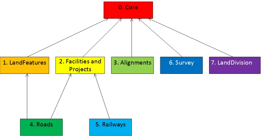
Figure 1. InfraGML Part Dependencies
The boxes above represent InfraGML Parts. Arrows show Part dependencies. The Part dependencies derive from the dependencies of the InfraGML Requirements Classes contained in these Parts. The reader should rely more on the InfraGML Requirements Class dependencies and only use the Part dependencies as a guide for knowing which InfraGML Part standards to consider.
LandInfra
0
Facility
2
Survey
6
LandDivision
7
Condominium
7
Project
2
Equipment
6
SurveyResults
6
Observations
6
Alignment
3
Road
4
RoadCrossSection
4
Railway
5
LandFeature
1
Sampling
6
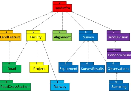
Figure 2. LandInfra Requirements Classes grouped into InfraGML Parts
7.
Requirements Classes for this Part
7.1 Structural Overview of Requirements Classes
The Requirements Classes for this Part of the InfraGML encoding standard (shown in blue in Figure 3 below) are defined in this Clause 7. Requirements Classes from other Parts upon which this Part’s Requirements Classes are dependent (Core shown in beige in Figure 3 below) are listed here but defined in the documentation of their respective Parts. External OGC and ISO standards on which Requirements Classes in this Standard depend (shown in pink in Figure 3 below) are also listed. Below is a brief summary of the
function of each of these Requirements Classes.
Figure 3. Requirements Classes for this Part and their Dependencies
7.1.1 Requirement Classes Defined in This Part
LandDivision
Land can be divided up into LandDivisions. These can either be public (political, judicial, or executive) or private in nature. The former are AdministrativeDivisions and the latter are InterestsInLand. Both of these are specified in the LandDivision Requirements Class, though condominium interests in land are specified in a separate, Condominium
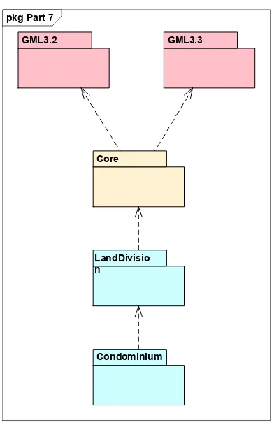
pkg Part 7
GML3.3 GML3.2
Core
LandDivisio n
Requirements Class. The geometrical shape of these spatial units is modelled independently from their administrative or legal status, (see LandInfra UML, Error! Reference source not found.Error! Reference source not found.).
Condominium
A CondominiumUnit is a concurrent ownership of real property that has been divided into private and common portions [2, 3]. The privately owned part is made up of clearly demarcated, floor related parts of a building (BuildingPart), as specified by a
CondominiumScheme. CondominiumUnit owners are members of a mandatory owners’ association. Moreover, each CondominiumUnit has a share in the common parts of the property.
The Condominium Requirements Class includes information about condominium units, buildings and schemes. The Condominium Requirement Class is dependent on the LandDivision Requirement Class.
7.1.2 Dependent Requirement Classes Defined in Other Parts
The Requirements Classes defined in this Part are dependent on the following Requirements Classes from other Parts.
Part 0. LandInfra Core
LandInfra is the core Requirements Class and is the only mandatory Requirements Class. This class contains information about the Land and Infrastructure dataset that can contain information about facilities, land features, documents, professional, survey marks,
surveys, sets, and feature associations. LandInfra also contains the definition of types common across other Requirements Classes, such as the Status CodeList.
7.1.3 Other Standards upon which the Requirement Classes of this Part Depend
For external OGC and ISO standards on which Requirements Classes in this Standard depend, a brief summary of the function of each of these Standards is described below.
GML 3.2
OGC 07-036, OpenGIS® Geography Markup Language (GML) Encoding Standard, v3.2 provides most of the geometry types (e.g., Point, LineString, Polygon) used for spatial representations in this Standard. Defines Coordinate Reference Systems. Supports the General Feature Model upon which this Standard is based.
GML 3.3
OGC 10-129r1, OGC® Geography Markup Language (GML) — Extended schemas and encoding rules, v3.3 defines the linear referencing concepts (e.g., linear element, distance along, Linear Referencing Methods) used for linearly referenced locations in this
7.2 Requirements Class: LandDivision
Requirements Class /req/landdivision
Target type Conforming application
Name LandDivision
Dependency /req/core (from InfraGML Part 0) Requirement /req/landdivision/elements
7.2.1 Implementation decisions regarding OGC 15-111r1 UML
The following implementationtation decisions have been made regarding the OGC 15-111r1 LandInfra Requirements Class UML:
1. GML will not allow an element to be associated with another element if it is already on the part side of a composition association. For example, if, as the 15-111r1 Figure 62 UML shows, LandParcel is a compositional part of LandPropertyUnit, then it cannot also be associated with Easement. Therefore the composition association has been replaced by a mandatory, uni-directional (1..*) association from LandPropertyUnit to LandParcel. The LandParcel-Easement association has been simplified to become uni-directional from Easement to LandParcel.
7.2.2 Specific Requirements for this Requirements Class
Requirement /req/landdivision/elements
A conforming application shall support the LandDivision XML elements listed in Table 1 below, in accordance with the GML XSD specified in http://schemas.opengis.net/infragml/part7/1.0/landdivision.xsd.
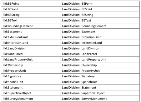
An application conforming to this standard shall support the LandDivisionXML elements listed below in Table 1 in accordance with the GML XSD specified in http://schemas.opengis.net/infragml/part7/1.0/landdivision.xsd. LandDivisionXML element names are shown with a XML namespace prefix of “lild”. Corresponding LandInfra UML classes are shown with their LandInfra Requirements Class prefix of “LandDivision”.
InfraGML XML element LandInfra UML Class
lild:AdministrativeDivision LandDivision::AdministrativeDivision
lild:BEExplicitFace LandDivision::BEExplicitFace
lild:BEExtrudedFace LandDivision::BEExtrudedFace
lild:BEFace LandDivision::BEFace
lild:BEPoint LandDivision::BEPoint
lild:BESolid LandDivision::BESolid
lild:BEString LandDivision::BEString
lild:BEText LandDivision::BEText
lild:BoundingElement LandDivision::BoundingElement
lild:Easement LandDivision::Easement
lild:ExtrusionLimit LandDivision::ExtrusionLimit
lild:InterestInLand LandDivision::InterestInLand
lild:LandDivision LandDivision::LandDivision
lild:LandParcel LandDivision::LandParcel
lild:LandPropertyUnit LandDivision::LandPropertyUnit
lild:Ownership LandDivision::Ownership
lild:PropertyUnit LandDivision::PropertyUnit
lild:Signatory LandDivision::Signatory
lild:SpatialUnit LandDivision::SpatialUnit
lild:Statement LandDivision::Statement
lild:SuperficieObject LandDivision::SuperficieObject
lild:SurveyMonument LandDivision::SurveyMonument
7.3 Requirements Class: Condominium
Requirements Class /req/condominium
Target type Conforming application
Name Condominium
Dependency /req/landdivision
Requirement /req/condominium/elements
7.3.1 Implementation decisions regarding OGC 15-111r1 UML
The following implementation decisions have been made regarding the OGC 15-111r1 Condominium Requirements Class UML:
1. LandInfra UML specifies CondominiumBuilding as subtype of Facility::Building, thereby creating a dependency on InfraGML Part 2 Facility. While this modelling is adequate, the benefit does not outweigh the cost of dependency. Waiting for linking with IFCs, CondominiumBuilding is here made subtype of LandInfra::Feature, similar to the modelling chosen for SuperficieObject (LandInfra UML 7.10.2.6)
2. GML will not allow an element to be associated with another element if it is already on the part side of a composition association. For example, if, as the 15-111r1 Figure 69 UML shows, BuildingPart is a compositional part of CondominiumBuilding, then it cannot also be associated with CondominiumUnit. Therefore the composition association has been replaced by a mandatory, uni-directional association from BuildingPart to CondominiumBuilding. The redundant CondominiumScheme-CondominiumBuilding association can now be dropped, as it is possible to determine the
CondominiumBuildings participating in a CondominiumScheme by tracing from CondominiumScheme to CondominiumUnit to BuildingPart to CondominiumBuilding.
7.3.2 Specific Requirements for this Requirements Class
Requirement /req/condominium/elements
A conforming application shall support the Condominium XML elements listed in Table 2 below, in accordance with the GML XSD specified in http://schemas.opengis.net/infragml/part7/1.0/condominium.xsd.
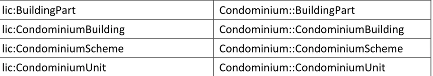
An application conforming to this standard shall support the Condominium XML elements listed below in Table 2 in accordance with the GML XSD specified in http://schemas.opengis.net/infragml/part7/1.0/condominium.xsd. Condominium XML element names are shown with a XML namespace prefix of “lic”. Corresponding LandInfra UML classes are shown with their LandInfra Requirements Class prefix of “Condominium”.
lic:BuildingPart Condominium::BuildingPart
lic:CondominiumBuilding Condominium::CondominiumBuilding
lic:CondominiumScheme Condominium::CondominiumScheme
lic:CondominiumUnit Condominium::CondominiumUnit
Table 2. InfraGML Condominium XML elements with corresponding LandInfra UML classes
8.
Media Types for any data encoding(s)
Annex A: Conformance Class Abstract Test Suite (Normative)
A.1 Conformance class: LandDivision
/conf/landdivision
Requirements /req/landdivision
Dependency /conf/core(from InfraGML Part 0)
Test /conf/landdivision/elements
Requirement /req/landdivision/elements
Test purpose Verify that the conforming application supports the LandDivision XML elements listed in Table 1 in accordance with the GML XSD specified in http://schemas.opengis.net/infragml/part7/1.0/ landdivision.xsd.
Test method Inspect the GML output to verify the above requirement.
Test type Capability
A.2 Conformance class: Condominium
/conf/condominium
Requirements /req/condominium Dependency /conf/landdivision
Test /conf/condominium/elements
Requirement /req/condominium/elements
Test purpose Verify that the conforming application supports the Condominium XML elements listed in Table 2 in accordance with the GML XSD specified in
http://schemas.opengis.net/infragml/part7/1.0/condominiu m.xsd
Test method Inspect the GML output to verify the above requirement.
Annex B: Sample XML (Informative)
B. 1 Complete land division and condominium example
The following XML example document demonstrates all attributes and roles from all classes contained in the LandDivision and Condominium RCs, except for bounding elements which are shown in Annex Error! Reference source not found..
<?xml version="1.0" encoding="UTF-8"?>
<li:LandInfraDataset xmlns:lic="http://www.opengis.net/infragml/condominium/1.0"
xmlns:lild="http://www.opengis.net/infragml/landdivision/1.0"
xmlns:li="http://www.opengis.net/infragml/core/1.0" xmlns:gml="http://www.opengis.net/gml/3.2"
gml:id="c00" xmlns:gmllr="http://www.opengis.net/gml/3.3/lr"
xmlns:gmllro="http://www.opengis.net/gml/3.3/lro" xmlns:xlink="http://www.w3.org/1999/xlink"
xmlns:xsi="http://www.w3.org/2001/XMLSchema-instance"
<li:author>Erik Stubkjær, Aalborg University, Denmark</li:author> <li:infraVersion>1.0</li:infraVersion>
<li:language>English</li:language>
<li:defaultCRS xlink:href="urn:ogc:def:crs:EPSG::4094"/> <!-- Administrative Division --> <li:feature>
<lild:AdministrativeDivision gml:id="ad1">
<lild:adID>
<lild:ID>
<li:identifier>851</li:identifier>
</lild:ID>
</lild:adID>
<lild:adType>Municipality</lild:adType>
<lild:AdministrativeDivision gml:id="ad2">
<li:documentType>easementEstablishment</li:documentType>
<li:documentContent>DocumentContent.odt</li:documentContent>
</lild:landRecordingDocumentId>
<lild:type xlink:href="http://example.com/EasementType#rightOfWay" xlink:title="RightOfWay"/>
<lild:beneficiaryParty>Current owner of LandParcel 'lp'</lild:beneficiaryParty>
<lild:permittedUse>Context-specific description of the permitted use</lild:permittedUse>
<lild:across xlink:href="lp"/>
</lild:Easement> </li:feature>
<!-- SurveyMonument --> <li:feature>
<lild:SurveyMonument gml:id="sm">
<lild:type xlink:href="http://example.com/SurveyMonumentType#boundaryMark" xlink:title="boundaryMark"/>
<lild:LandPropertyUnit gml:id="lpu">
<lild:documentation/>
<lild:propertyUnitID>
<lild:ID>
</lild:ID>
</lild:propertyUnitID>
<lild:ownership xlink:href="os"/>
<lild:postAddress>Post address of LandPropertyUnit</lild:postAddress>
<lild:landParcel>
<lild:currentLandUse>Residential</lild:currentLandUse>
<lild:plannedLandUse>Residential, low and detached</lild:plannedLandUse>
<lild:parcelState>current</lild:parcelState>
<lild:SuperficieObject gml:id="so1">
<lild:ID>
<li:documentContent>Details on location, access and relation to surface LandParcels, which may be formally provided through LandParcel, SpatialUnit, and
Easement</li:documentContent>
<lic:subSurfaceFloor>false</lic:subSurfaceFloor>
<lic:floorArea uom="m2">87</lic:floorArea>
<lic:buildingPartType>condominiumMainPart</lic:buildingPartType>
<li:feature>
<lic:CondominiumScheme gml:id="cs1">
<li:documentID>
<li:ID>
<li:identifier>678</li:identifier>
</li:ID>
</li:documentID>
<li:documentType>CondominiumScheme</li:documentType>
<lild:type xlink:href="http://example.com/StatementType#condominiumScheme" xlink:title="condominiumScheme"/>
<lic:buildingDescription>Free-text building description</lic:buildingDescription>
<lic:unit>
<lic:shareInJointFacilities>23/108</lic:shareInJointFacilities>
<lic:condominiumUseType
<lic:buildingPartType>condominiumMainPart</lic:buildingPartType>
<lic:shapeAndLocation/>
<lic:buildingPartType>condominiumAccessoryPart</lic:buildingPartType>
<lic:shapeAndLocation/>
<lic:partOf xlink:href="cb1"/>
</lic:accessoryPart>
</lic:CondominiumUnit>
</lic:unit>
<lic:unit>
<lic:CondominiumUnit gml:id="cu2">
<lild:documentation/>
<lild:propertyUnitID>
<lild:ID>
<li:identifier>23</li:identifier>
</lild:ID>
</lild:propertyUnitID>
<lild:ownership/>
<lic:shareInJointFacilities>10/108</lic:shareInJointFacilities>
<lic:mainPart>
<lic:BuildingPart gml:id="bp4">
<lic:floorNumber>2</lic:floorNumber>
<lic:subSurfaceFloor>false</lic:subSurfaceFloor>
<lic:buildingPartType>condominiumMainPart</lic:buildingPartType>
<lic:shapeAndLocation/>
<lic:partOf xlink:href="cb1"/>
</lic:BuildingPart>
</lic:mainPart>
</lic:CondominiumUnit>
</lic:unit>
</lic:CondominiumScheme> </li:feature>
B. 2 Bounding Elements example
This example demonstrates how Bounding Elements are encoded. Every type is included as if it were valid for Land Parcels, though some may be more appropriate for
Condominium Building Parts. Coordinate values are chosen for clarity and may
therefore not be realistic for real Land Parcels or Building Parts. See OGC 15-111r1 for a complete definition of the various types of Bounding Elements.
The first three Spatial Units demonstrate the difference in dimension only and are not complete in definition, as they lack Bounding Elements.
3D
LIM
2D
<?xml version="1.0" encoding="UTF-8"?>
<LandInfraDataset xmlns="http://www.opengis.net/infragml/core/1.0" xmlns:lild="http://www.opengis.net/infragml/landdivision/1.0"
xmlns:gml="http://www.opengis.net/gml/3.2" gml:id="BE"
xmlns:xlink="http://www.w3.org/1999/xlink" xmlns:gmllr="http://www.opengis.net/gml/3.3/lr" xmlns:gmllro="http://www.opengis.net/gml/3.3/lro"
xmlns:xsi="http://www.w3.org/2001/XMLSchema-instance"
xsi:schemaLocation="http://www.opengis.net/infragml/landdivision/1.0 Part7LandDivision0410.xsd">
<datasetID>
<ID>
<identifier>BE</identifier>
</ID> </datasetID>
<dateTime>2017-03-22T10:00:00</dateTime> <datasetVersion>1.0</datasetVersion> <application/>
<author>Paul Scarponcini</author> <infraVersion>1.0</infraVersion> <language>English</language> <defaultCRS/>
<feature>
<lild:LandPropertyUnit gml:id="lpu1">
<lild:documentation></lild:documentation>
<lild:propertyUnitID>
<lild:ID>
<identifier></identifier>
</lild:ID>
</lild:propertyUnitID>
</lild:ID>
The 2D-T Spatial Unit demonstrates the use of the BEText Bounding Element in 2D:
<lild:isComplete>true</lild:isComplete>
<lild:geometry>
"Beginning at Survey Monument SM1, thence North 50 feet, thence East 100 feet, thence South 50 feet, thence West 100 feet to the point of beginning"
</lild:geometry>
</lild:BEText>
</lild:boundingElement>
</lild:SpatialUnit>
</lild:shapeAndLocation>
</lild:LandParcel>
The 2D-P Spatial Unit demonstrates the use of the BEPoint Bounding Element in 2D, where a single representative point within the Land Parcel is used. The 2D-R Spatial Unit demonstrate the use of the BEString ring type of Bounding Element in 2D, where the exterior boundary is specified as a closed linestring geometry. 2D-H extends the ring example to include an interior ring defining a hole boundary.
</lild:cadastralParcelId>
<lild:parcelArea uom="sf">4800</lild:parcelArea>
<lild:shapeAndLocation>
<lild:SpatialUnit gml:id="su2D-H">
<lild:spatialUnitID>
<lild:ID>
<identifier></identifier>
</lild:ID>
</lild:spatialUnitID>
<lild:dimension>2D</lild:dimension>
<lild:boundingElement>
<lild:BEString gml:id="hole1">
<lild:boundingElementID></lild:boundingElementID>
<lild:isComplete>true</lild:isComplete>
<lild:geometry>
<gml:MultiCurve gml:id="mc1">
<gml:curveMember>
<gml:LineString gml:id="ls2">
<gml:pos>200 0</gml:pos>
<gml:pos>300 0</gml:pos>
<gml:pos>300 50</gml:pos>
<gml:pos>200 50</gml:pos>
<gml:pos>200 0</gml:pos>
</gml:LineString>
</gml:curveMember>
<gml:curveMember>
<gml:LineString gml:id="ls3">
<gml:pos>270 30</gml:pos>
<gml:pos>270 40</gml:pos>
<gml:pos>290 40</gml:pos>
<gml:pos>290 30</gml:pos>
<gml:pos>270 30</gml:pos>
</gml:LineString>
</gml:curveMember>
</gml:MultiCurve>
</lild:geometry>
<lild:stringType>ring</lild:stringType>
</lild:BEString>
</lild:boundingElement>
</lild:SpatialUnit>
</lild:shapeAndLocation>
</lild:LandParcel>
The 2D-CC Spatial Unit demonstrate the use of the other four types of BEString
Bounding Elements in 2D: partial, unstructured, structured, and topological. The partial type specifies that only part of the common boundary (linestring ls4) is used by 2D-CC. The 2D-TC Spatial Unit demonstrates how a Bounding Element geometry (linestring ls7) can be shared by two Spatial Units (in opposite directions). Note that 2D-TC uses
another part of the common boundary (linestring ls4)
<lild:ID>
<identifier></identifier>
</lild:ID>
</lild:spatialUnitID>
<lild:dimension>2D</lild:dimension>
<lild:boundingElement xlink:href="partial1">
</lild:boundingElement>
<lild:boundingElement>
<lild:BEString gml:id="topo2">
<lild:boundingElementID></lild:boundingElementID>
<lild:isComplete>false</lild:isComplete>
<lild:geometry xlink:href="ls7"></lild:geometry>
<lild:stringType>topological</lild:stringType>
<lild:direction>forward</lild:direction>
</lild:BEString>
</lild:boundingElement>
</lild:SpatialUnit>
</lild:shapeAndLocation>
</lild:LandParcel>
The last two Spatial Units are 3D. The first, 3D-FC has a combination of the three
</gml:Polygon>
</gml:surfaceMember>
</gml:Shell>
</gml:exterior>
</gml:Solid>
</lild:geometry>
</lild:BESolid>
</lild:boundingElement>
</lild:SpatialUnit>
</lild:shapeAndLocation>
</lild:LandParcel>
</lild:landParcel>
</lild:LandPropertyUnit> </feature>
B. 3 Condominium example
A PropertyUnit consist of the LandParcel 17b with a building of two stairwells and three floors. The owner wants to subdivide the PropertyUnit into CondominiumUnits. In the example, the CondominiumUnits generally consist of an apartment and a storeroom, as specified in the CondominiumScheme below, here showing only two
<?xml version="1.0" encoding="UTF-8"?>
<?xml-stylesheet type="text/xsl" href="CondominiumExample0518.xsl"?> <li:LandInfraDataset xmlns="http://www.opengis.net/infragml/condominium/1.0"
xmlns:lild="http://www.opengis.net/infragml/landdivision/1.0"
xmlns:li="http://www.opengis.net/infragml/core/1.0" xmlns:gml="http://www.opengis.net/gml/3.2"
gml:id="c00" xmlns:gmllr="http://www.opengis.net/gml/3.3/lr"
xmlns:gmllro="http://www.opengis.net/gml/3.3/lro" xmlns:xlink="http://www.w3.org/1999/xlink"
xmlns:xsi="http://www.w3.org/2001/XMLSchema-instance"
<li:name>Part7 Condominium Dataset</li:name>
<li:description>LandInfra dataset to test content for Part7 Condominium</li:description> <li:dateTime>2017-03-10T21:00:00</li:dateTime>
<li:datasetVersion>1.0</li:datasetVersion> <li:application>manual</li:application>
<li:author>Erik Stubkjær, Aalborg University, Denmark</li:author> <li:infraVersion>1.0</li:infraVersion>
<li:language>English</li:language> <li:defaultCRS/>
<!--
The present dataset is needed for establishment of CondominiumUnits. They consist of one or more parts of CondominiumBuilding(s). Future CondominiumUnits owners get exclusive rights to their CondominiumUnit as well as a mandatory share in the joint elements of the PropertyUnit: Roof, outer walls, technical installations, the LandParcel(s), etc. The sale and future owners are out of scope relative to the present condominiumSchemeEstablishment.
The LandSurveyor documents the requested through the present CondominiumScheme, which provides the data for the above tabular and graphical parts.
-->
<!-- The LandPropertyUnit to be subdivided into CondominiumUnits --> <li:feature>
<lild:LandPropertyUnit gml:id="lpu1">
<lild:documentation xlink:href="st1"/>
<lild:propertyUnitID>
<lild:ID>
<li:identifier>123</li:identifier>
<li:scope>Recording District</li:scope>
Jurisdiction-specific text which identifies the PropertyUnit and LandParcel(s) concerned, describes the building(s) to be subdivided, and declares the establishment of CondominiumUnits, which are detailed below. Completed with signatures of owner(s), professional and land registry recordings.
</lild:ID>
<CondominiumBuilding gml:id="cb1">
<gml:description>Location of CondominiumBuilding on LandParcel</gml:description>
<li:spatialRepresentation>
</li:SpatialRepresentation>
</li:spatialRepresentation>
<buildingNumber>1234</buildingNumber>
<parcelLocation xlink:href="lp1"/>
</CondominiumBuilding> </li:feature>
<!-- The CondominiumScheme with CondominiumUnits and their BuildingParts. Of a total of 10 units, only two are shown -->
<li:feature>
<CondominiumScheme gml:id="cs1">
<li:documentID>
<li:ID>
<li:identifier>001</li:identifier>
</li:ID>
</li:documentID>
<li:documentType>condominiumSchemeEstablishment</li:documentType>
<lild:type
xlink:href="http://example.com/StatementType#condominiumSchemeEstablishment" xlink:title="condominiumSchemeEstablishment"/>
<lild:draftsman>
<li:Professional gml:id="prof1">
<li:fullName>Hans Pedometer</li:fullName>
<li:type xlink:href="http://example.com/ProfessionalType#landSurveyor" xlink:title="landSurveyor"/>
<li:company>Measurewell</li:company>
<li:registration>LicenseX_1968-43</li:registration>
<li:licensingCountry>DK</li:licensingCountry>
<buildingDescription>Optional description of building</buildingDescription>
<unit>
<shareInJointFacilities>10/120</shareInJointFacilities>
<condominiumUseType/>
<mainPart>
<buildingPartType>condominiumAccessoryPart</buildingPartType>
<lild:stringType>structured</lild:stringType>
<shareInJointFacilities>11/120</shareInJointFacilities>
<BuildingPart gml:id="bp9a">
<floorNumber>Basement</floorNumber>
<subSurfaceFloor>true</subSurfaceFloor>
<buildingPartType>condominiumAccessoryPart</buildingPartType>
<shapeAndLocation>
<buildingPartType>condominiumAccessoryPart</buildingPartType>
</lild:BEString>
</lild:boundingElement>
</lild:SpatialUnit>
</shapeAndLocation>
<partOf xlink:href="cb1"/>
</BuildingPart>
</accessoryPart>
</CondominiumUnit>
</unit>
</CondominiumScheme> </li:feature>
Annex C: Revision history
Date Release Author Paragraph modified
Description 20170611 107r1 Paul
Scarponcini
Annex B Fixed GML striping; added complete example; removed Cadastre example
20170814 107r2 Paul
Scarponcini
Annex D: Bibliography
[1] OGC 08-131r3 The Specification Model — A Standard for Modular specifications, Open Geospatial Consortium, (2009)
[2] Des Ormeaux, Anne and Jean-Marie Lessard. Legal Dictionary of Property in Canada - Dictionnaire juridique de la propriété au Canada, [online], 2009. [dualjuridik.org, 6. November 2015]