CONCEPTS, MODELS AND IMPLEMENTATION OF THE MARINE SPATIAL DATA
INFRASTRUCTURE IN GERMANY (MDI-DE)
C. Rüh, R. Bill
Rostock University, Professorship for Geodesy & Geoinformatics, Germany - {christian.rueh|ralf.bill}@uni-rostock.de
KEY WORDS: Spatial information science, interoperability, web-based, marine, data infrastructure
ABSTRACT:
In Germany currently the development of a marine data infrastructure takes place with the aim of merging information concerning the fields coastal engineering, hydrography and surveying, protection of the marine environment, maritime conservation, regional planning and coastal research. This undertaking is embedded in a series of regulations and developments on many administrative levels from which specifications and courses of action derive. To set up a conceptual framework for the marine data infrastructure (MDI-DE) scientists at the Professorship for Geodesy and Geoinformatics at Rostock University are building a reference model, evaluating meta-information systems and developing models to support common workflows in marine applications.
The reference model for the marine spatial data infrastructure of Germany (MDI-DE) is the guideline for all developments inside this infrastructure. Because the undertaking is embedded in a series of regulations and developments this paper illustrates an approach on modelling a scenario for the Marine Strategy Framework Directive (MSFD) using the Unified Modelling Language (UML).
Evaluating how other countries built their marine spatial infrastructures is of main importance, to learn where obstacles are and errors are likely to occur. To be able to look at other initiatives from a neutral point of view it is necessary to construct a framework for evaluation of marine spatial data infrastructures. Spatial data infrastructure assessment approaches were used as bases and were expanded to meet the requirements of the marine domain. As an international case-study this paper will look at Canada’s Marine Geospatial Data Infrastructure (MGDI), COINAtlantic and GeoPortal.
1. INTRODUCTION
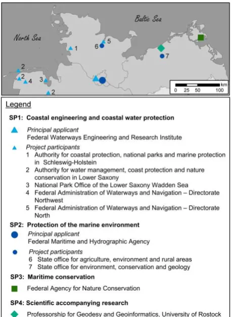
In Germany currently the development of a marine data infrastructure takes place with the aim to integrate existing technical developments (NOKIS – a metadata database in Germany – and the spatial data infrastructure of the German Federal Maritime and Hydrographic Agency [GDI-BSH]) as well as merging information concerning the fields coastal engineering, hydrography and surveying, protection of the marine environment, maritime conservation, regional planning and coastal research. The funded parties and their sub projects (SPs) in this project (sponsored by the Federal Ministry of Education and Research [BMBF]) are (see figure 1):
- Federal Waterways Engineering and Research Institute (BAW, SP1 - “coastal engineering and coastal water protection”), - German Federal Maritime and Hydrographic Agency (BSH, SP2 - “protection of the marine environment”),
- German Federal Agency for Nature Conservation (BfN, SP3 - “maritime conservation”) and
- Professorship for Geodesy and Geoinformatics at Rostock University (GG, SP4 – “scientific accompanying research”). This undertaking is embedded in a series of regulations and developments on many administrative levels from which specifications and courses of action derive. On the European level it is the INSPIRE (Infrastructure for Spatial Information in the European Community) initiative as well as the Marine Strategy Framework Directive (MSFD), the Water Framework Directive (WFD) and Natura2000 with their regulation counterparts for Germany and its federal states (MSRL, WRRL, FFH-RL, VS-RL).
To keep track of all the things mentioned and to give the marine data infrastructure (MDI-DE) a conceptual framework scientists at the Professorship for Geodesy and Geoinformatics at Rostock University are building a reference model, evaluating meta-information systems and developing models to support common workflows in marine applications.
Figure 1. Project participants, sub projects (SP) and their locations
2. COMPOSITION OF THE REFERENCE MODEL
Modelling is a necessity for the development of a spatial data infrastructure in particular when lots of partners are involved and many requirements should be met. The reference model for MDI-DE is the guideline for all developments inside this infrastructure and is based on the ISO Reference Model for Open Distributed Processing [RM-ODP] and other reference models for federal states and Germany as a whole. It consists of several sub models which focus on different aspects of the marine data infrastructure.
The aims, requirements and interests of the participants towards the infrastructure are defined in the business model which corresponds to the enterprise viewpoint of RM-ODP. Certain scenarios – which are part of the process model and are modelled as workflows – are the base for modelling the business processes. The participants (or actors) and their roles inside the system are collected in the role model so that one can see what types of data a certain actor holds, for example. The flow of the scenarios and the state of the data inside the processes are described in the process model which corresponds to the engineering viewpoint of RM-ODP. This model divides the processes in activities and shows the course of actions and the state of data. It is being modelled by activity and sequence diagrams. The architecture model corresponding to the informational and computational viewpoints of RM-ODP characterizes the technical components (e.g. services, interfaces and clients) as well as their functions and the interrelation between them. Since the architecture is service-oriented mainly service types and their roles inside the scenarios are of main importance in this model. The precise realization of the architecture model leads to implementation specifications for which the implementation model is responsible. The implementation model corresponds to the technology viewpoint of RM-ODP and basically uses existing specifications to come to the implementation specifications. The existing specifications are expanded with profiles to match the requirements of the marine domain.
3. MODELLING A SCENARIO FOR THE MSFD
Because the undertaking is embedded in a series of regulations and developments an approach on modelling a scenario for the Marine Strategy Framework Directive (MSFD) using the Unified Modelling Language (UML) will be outlined. Since the modelling should be in step with actual practice as good as possible, an overview about the MSFD and the data this directive requires will be provided first.
3.1 Outline MSFD
The marine strategy framework directive (MSFD) is a European directive and aims at achieving resp. maintaining a good environmental status (GES) for the seas. The directive calls in the member states to develop and implements strategies that protect and conserve marine environment, prevent its deterioration and – where applicable – restore damaged marine ecosystems. A first report described the current situation resp. condition, defined what a GES is and how the GES can be achieved and maintained. To measure the results on a regular base reports for the EU have to be prepared. For that purpose indicators were defined. These indicators will be evaluated and enter the evaluation of a superordinate descriptor. All eleven descriptors induce the total evaluation of the seas and the eleven descriptors are (source: [MSFD-GES]): 1. Biological diversity, 2. Non-indigenous species, 3. Population of commercial fish /
shell fish 4. Elements of marine food webs, 5. Eutrophication, 6. Sea floor integrity, 7. Alteration of hydrographical conditions, 8. Contaminants, 9. Contam. in fish & seafood for human consumption, 10. Marine litter and 11. Introduction of energy, including underwater noise.
3.2 Modelling the construction resp. evaluation of indicators and descriptors
In this scenario an actor has to evaluate indicators resp. descriptors to prepare a report to the EU for the MSFD.
Figure 2. UML-activity diagram to evaluate an indicator
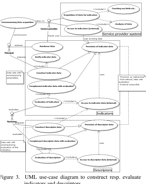
Figure 3. UML use-case diagram to construct resp. evaluate indicators and descriptors
The business model defined that the topic “MSFD” should have a high priority and the role model specified that the federal agency for nature conservation for instance has to deal with the MSFD in the sense that it records data needed for the reports to the EU. It gathers data about the population of sea birds (descriptor 1 of the MSFD) for example. The different roles of
the role model can be recognized in the use-case diagrams. In figure 3 the federal agency for nature conservation could be principal or reviewer as well as both. The process model describes the operations of the scenario, inter alia, with activity diagrams. The activity diagram shown in figure 2 takes the use-case “Evaluation of indicators” off the use-case diagram (figure 3) and characterizes its course of actions. Firstly an indicator is requested from a service which contains the limits for evaluation. The parameter recorded then gets compared to the limits and if it is under “limit4” but above” limit3” the indicator will be evaluated with “good” and sent back to the service. Figure 3 furthermore shows that the provision of indicators resp. descriptors uses services. This is a link to the architecture model which constituted the orientation towards the usage of services.
But the MSFD is not the only important directive MDI-DE focusses on. As outlined in the introduction there is inter alia the INSPIRE directive playing an important role in the marine sector, too. The next chapter will analyse the extent of said role
4. REVIEW OF INSPIRE DATA SPECIFICATIONS ANNEX III WITH RELEVANCE TO THE MARINE
FRAMEWORK DIRECTIVE
The drafts of the INSPIRE data specifications for annex II and III have been published recently. This chapter shows the relevant themes of the specifications addressing the marine information community and compares them with existing requirements for marine data which are in preparation for the European Marine Framework Directive (MFD).
4.1 Analysis of the specifications
We found out that the following INSPIRE specifications are of special importance to the MFD:
Agricultural and Aquaculture Facilities (AF)
Area management/restriction/regulation zones and reporting units (AM)
Bio-geographical Regions (BR) Energy Resources (ER)
Environmental Monitoring Facilities (EF) Habitats and Biotopes (HB)
Land Use (LU)
Mineral Resources (MR) Natural Risk Zones (NZ)
Oceanographic Geographical Feature (OF) Species Distribution (SD)
Sea Regions (SR)
Because of limited amount of space only two specifications are discussed in more detail. Species Distribution (SD): This specification provides a schema for the modelling of the geographical distribution of the occurrence of animal and plant species aggregated by grid, region, administrative unit or other analytical unit. Sea Regions (SR): Sea regions are named seas, like Baltic Sea, and subdivisions and aggregation of seas, according to a range of physical or chemical properties. “Sea Region” is a defined area of common (physical) characteristics. The key relationships between SR and the other INSPIRE themes are “located in”, “specialization of” and “property of”. The shore is proposed to be managed by the land cover theme.
4.2 Conclusions
The specifications Sea Region, Oceanographical and Geographical Feature, Habitats and Biotops and Species
Distribution will be of main importance for the modelling of marine data in accordance to MSFD. Nevertheless the other themes stated in this paper are also involved in use cases which describe the management of the marine environment. In a next step we will adapt the data models used to describe the indicators for the MSFD to the INSPIRE application schemas.
5. EVALUATION OF MARINE SPATIAL DATA INFRASTRUCTURES
The components of an SDI were outlined inter alia in [SRW06] which answered the question how people can be linked to data (both are already components of an SDI): by standards, policies and access networks (see figure 4).
Figure 4. Components of SDI (source: [SRW06])
[SRW08] takes these components and defines areas that should be inspected when assessing spatial data infrastructures (SDIs): Policy Level - Policy, Management Level - Standards and Access Network, Operational Level - Access Network and Data, Other Influencing Factors - People, Performance Assessment. For the defined areas the paper then suggests
Standards 15. Interoperability 16. Organizational arrangements for
standardization Table 1. Indicators for comparing SDIs on the basis of Web
services and data management (source: [NRWG07])
[NRWG07] is undertaking a similar approach for the assessment of SDIs by proposing three components (data and metadata, web services, standards) accompanied by several indicators for each of the components. Since indicators could have a technical or organizational meaning, they are further classified by these two factors (see table 1).
We may have to adjust the so far outlined components because we want to evaluate and compare marine spatial data infrastructures (MSDIs), which are “the component of a National SDI that encompasses marine and coastal geographic and business information in its widest sense. An MSDI would typically include information on seabed bathymetry (elevation), geology, infrastructure (e.g. wrecks, offshore installations, pipelines, cables); administrative and legal boundaries, areas of conservation and marine habitats and oceanography.” [IR09]. When having a look at [BBLB11] we find out that “the four main components of a successful coastal and ocean information network (COIN), as an important component of an SDI, are:
online access to data using recognized standards metadata catalogues used to search for geospatial data a web interface that allows users to search, access and
retrieve information from the most reliable sources active participation of data providers and data users to
ensure that the right data are available to contribute to more effective decision-making.“
These components are more or less equal to the five components (fig. 4) just in another form. When we compare them we come to:
online access to data using recognized standards people, data, standards and access networks metadata catalogues that can be used to search for
geospatial information
people, data, standards, policies and access networks
a web interface that allows users to search, access and retrieve the best available information from the most reliable sources
people, data, standards, policies and access networks
active participation of data providers and data users to ensure that the right data are available to contribute to more effective decision-making
people, data, policies
Because we have seen that the components of a general SDI and a MSDI are equal we can assume that we are able to apply the indicators mentioned in the two beforehand shown papers to the evaluation of a MSDI.
Due to the fact that MSDIs are special SDIs we had to ask ourselves if more indicators are needed to compare MSDIs. In [SRW08] in the list of possible indicators we do not find metadata at all although metadata is mentioned in the paper several times. [NRWG07] on the other hand lists metadata as a component so that the first 11 indicators also apply to metadata and indicator 7 (harmonization of data and metadata) mentions metadata explicitly. But what is not mentioned in both papers is the availability of metadata in general and a metadata catalogue (CSW) in particular. After all in times of widespread and agreed on metadata specifications (like ISO’s 19115) and services (OGC’s CSW) this would fit as an indicator to look at. In what way and by which institutions metadata is handled (metadata coordination) should also be a thing to look at. Since metadata is linked to “real” data we should also define an indicator which looks at the availability of web (map) services enabling interoperability and availability. To better understand how other marine initiatives got to their infrastructures and how they are
built a glance at the architecture should be thrown. The last thing which should be checked is whether the definitions for shorelines and/or maritime zones differ in varying MSDIs.
5.1.2 Compiling the framework
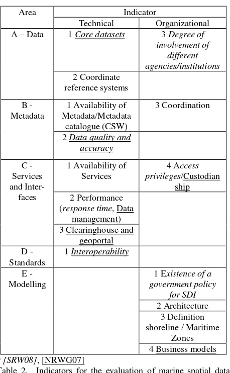
In table 2 one can see the old and new indicators and - if old - where they are sourced from. For clarity purposes the indicators are classified into the factors technical and organizational. The first area (A) covers the organizational and technical indicators regarding data. Because data is the most important thing in a MSDI this is the first area looked at. The indicator A1 (core datasets) can be found in [SRW08] and [NRWG07], too, and describes what basic reference spatial data is covered by a country’s MSDI. The datasets which could be covered are bathymetry, shoreline and other maritime zones like EEZ, marine cadastre, coastal imagery, marine navigation, tidal benchmarks and benthic/nature conservation habitats. Indicator A2 (coordinate reference systems) lists all the supported CRS of the MSDI while the last indicator (A3) looks at the degree of involvement of different agencies resp. institutions by reason that a MSDI has to incorporate various datasets coming from a wide range of agencies/institutions and these will be listed for this indicator.
For area B it is important that data is augmented by metadata so that one is able to find it and is able to know what the data is about later on. The indicator B1 (availability of metadata/a metadata catalogue [CSW]) looks at the availability of metadata and tries to answer the questions: is it searchable, how is it held and is it available through a standardized catalogue (CSW) interface? Because we are in the marine field much data will be sensor data thus making data quality and accuracy a big issue. That is why indicator B2 especially tells if metadata is available that handles how the measurements were done and how accurate they are. Indicator B3 (coordination) is used because metadata should be homogeneous inside the MSDI and it would be good if there is a central coordination unit dealing with implementing metadata rules.
For interoperability it is important that you are able to get marine-related data into any application of your choice and to not depend on a geoportal alone. Thus the indicator C1 (availability of services) lists all the available services. When you want to work with the data provided by services it is important that the services meet certain criteria regarding response time (indicator C2 - performance). Furthermore the system has to be able to cope with large data sets and there should be an update cycle with short intervals which is well documented. The MSDI should have a central entry point to access its data which is the geoportal resp. clearinghouse (indicator C3). It is important that there is a search functionality and map viewer. Additionally indicator C4 (access privileges/custodianship) asks if there was a focus on a role model which deals with actors or stakeholders of the system when the MSDI was modelled.
All areas so far involved standards in some way. Area D (in its only indicator D1 - Interoperability) analyses which standards are used and checks whether their usage lead to interoperability. Apart from that it asks if the stakeholders of the infrastructures are involved in standardization processes or organizations.
Area Indicator organizational viewpoint. It considers the existence of a government policy for (M)SDI (indicator E1) and thus answers the question if the government backs up the developments. This area also gazes at the varying definitions for shorelines and/or maritime zones in diverse MSDIs (indicator E3). To better understand how other marine initiatives got to their infrastructure and how they are built, the architecture (indicator E2) and in particular the underlying business models (indicator E4) are examined. All last three indicators (E2-E4) are not directly measureable and thus are only needed for reference.
5.2 International case study: Canada
5.2.1 Introduction
The national spatial data infrastructure (NSDI) is called Canadian Geospatial Data Infrastructure (CGDI) but is also known as “GeoConnections” and is divided into twelve nodes. The CGDI “recognizes that governments have a responsibility to make geospatial information available, and to ‘play their role’ in developing a knowledge economy in response to the needs of citizens, industry and communities in support of the economic, social and environmental well-being.” [LCE98]. The CGDI aims to help users access and integrate said geospatial information by facilitating the infrastructure. Thus the CGDI does not house the spatial data but provides the framework so that various authorities can provide their data through the use of common standards. The CGDI mainly consists of:
the GeoConnections Discovery Portal (GDP), a national search engine allowing providers to catalogue their data sets and users to search for it;
GeoGratis, a national repository where suppliers may place data for free distribution;
GeoBase, a national suite of framework layers that includes place names, a digital elevation model, a layer of satellite imagery, a road network, geodetic (survey reference) points, and a layer of administrative boundaries [AS07].
One component of the CGDI is the Marine Geospatial Data Infrastructure (MGDI) which goal is “to satisfy the geographic data needs of water-oriented stakeholders.” [NRC03]. The development of the MGDI is led by the Marine Advisory the MGDI and provides services that enables DFO employees to index and publish their and find, view and download other spatial data. The GeoPortal does not intend to be a data warehouse but rather acts as a clearing house for marine spatial data by using an open standards-based architecture [BCMSRM03].
Another initiative inside CGDI is COINAtlantic which “has implemented a coastal and ocean information network for the western North Atlantic.” [BBLB11]. The initiative is led by the Atlantic Coastal Zone Information Steering Committee (ACZISC) and aims at the provision of open access to spatial data to support integrated coastal and ocean management (ICOM) by adopting all standards of and complying with the architecture of the CGDI [SBLGC09].
5.2.2 Evaluation and Summary
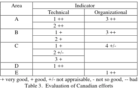
With its many core datasets, its open policy towards coordinate reference systems and the broad variety of involved agencies/institutions Canada’s approaches perform very good in area A. In area B a few points have to be deducted because there is no central marine-only CSW available and data quality does not have seemed to be of great importance. But apart from that there is much metadata available in catalogues and everything is well organized with recognition of international trends in standardisation. Area C is where the most points are lost because there could be more services available and a central geoportal is lacking. Unfortunately nothing really can be stated for C2 (performance) and C4 (custodianship). The performance in area D and E is overall great due to the facts that the CGDI is endorsing and/or investigating a multitude of standards and that the CGDI is the national spatial data infrastructure (NSDI) of Canada which means that it is implemented by the Canadian government and that the CGDI “[...] recognizes that governments have a responsibility to make geospatial information available [...].” [LCE98].
Area Indicator
Technical Organizational
A 1 ++ 3 ++
2 ++
B 1 + 3 ++
2 +
C 1 + 4 +/-
2 +/- 3 +
D 1 ++
E 1 ++
++ very good, + good, +/- not appraisable, - not so good, -- bad Table 3. Evaluation of Canadian efforts
In summary it can be stated that a lot has been done to overcome the tradition of holding data in silos for in-organization/institution-use only in Canada (see table 3). Through the adoption of the Canadian Geospatial Data Infrastructure (CGDI) Canada got to an interoperable MSDI based on widely adopted international standards which offers marine-themed data for (almost) everybody. The only problematic area to be seen is the division into several projects and thus missing a central entry point for marine data so that users do not have to look at several places to get the data they need.
6. REFERENCES
AS07: Sherin, A. G.: COINAtlantic: Planning for a Sustainable Future. In: Proceedings of CoastGIS 2007: 8th International Symposium on GIS and Computer Mapping for Coastal Zone Management, 2007
BCMSRM03: British Columbia Ministry of Sustainable Resource Management and Fisheries and Oceans Canada and GeoConnections Canada and Canadian Centre for Marine Communications: Towards a Cooperative Ocean Information Network of the Pacific (COINPacific) - Benefit Analysis British Columbia Ministry of Sustainable Resource Management, 2003
BBLB11: Butler, M.; Boudreau, P.; LeBlanc, C. & Baldwin, K.: Spatial Data infrastructures in Support of Ecosystem Based Management and Ecosystem Approach to Fisheries in the Caribbean. In: Towards Marine Ecosystem-based Management in the Wider Caribbean. 2011
DFO01: Department of Fisheries and Oceans Canada: Marine User Requirements for Geospatial Data - Summary 2001, www.geoconnections.org/publications/reports/marine/Marine_ User_Requirements_E.pdf
IR09: Russell, I.: HYDROGRAPHY and MARINE SPATIAL DATA INFRASTRUCTURE - Programme and Presentation
Abstracts. 2009.
www.ths.org.uk/documents/ths.org.uk/downloads/symposium_b rochure.pdf
LCE98: Labonte, J.; Corey, M. & Evangelatos, T.: Canadian Geospatial Data Infrastructure (CGDI) - Geospatial Information for the Knowledge Economy. In: Geomatica, 1998, 52, 214-222
MSFD-GES: Good Environmental Status (GES) of the Marine Environment, European Commission Environment. http://ec.europa.eu/environment/water/marine/ges.htm
NRC03: Natural Resources Canada: Marine geospatial data - safeguarding Canada's coastal and offshore areas, 2003 www.cgdi.gc.ca/programsCommittees/proCom_marine/marine_ factsheet_E.pdf
NRWG07: Najar, C.; Rajabifard, A.; Williamson, I. & Giger, C.: A Framework for Comparing Spatial Data Infrastructures on the basis of Web Services and Metadata Management: An Australian-Swiss Case Study. In: Research and Theory in Advancing Spatial Data Infrastructure Concepts. 2007, p. 201-213
SBLGC09: Sherin, A. G.; Butler, M. J.; Leblanc, C.; Gillespie, R. & Collins, N.: Coastal Ocean Information Network (ATLANTIC): From Concept to Reality: A Status Report. In: Coastal and Marine Geospatial Technologies, Springer, 2009, pp. 73-85
SRW06: Strain, L.; Rajabifard, A. & Williamson, I.: Marine Administration and Spatial Data Infrastructures. In: Marine Policy. 2006
SRW08: Steudler, D.; Rajabifard, A. & Williamson, I.: Chapter 10 - Evaluation and Performance Indicators to Assess Spatial Data Infrastructure Initiatives. In: A Multi-View Framework to Assess Spatial Data Infrastructures. 2008, p. 193-210
RM-ODP: Information technology – Open Distributed Processing – Reference Model: Architecture. International Standard ISO/IEC 10746-3 from 15.09.1996.
![Figure 4. Components of SDI (source: [SRW06])](https://thumb-ap.123doks.com/thumbv2/123dok/1875544.1169865/3.595.341.499.321.392/figure-components-sdi-source-srw.webp)