FOREST, EAST KALIMANTAN
Murniati1,2, Michael Padmanaba3, and Imam Basuki3
ABSTRACT
The forest of Gunung Lumut in Pasir District, East Kalimantan was designated for a protection forest in 1983. It is surrounded by 15 villages and one settlement lies inside it. Communities in those villages are dependent upon the landscape and forest resources mainly for non timber forest products. This study was focused on the perception of the communities on the importance of the landscape and forests. The study was conducted in two settlements, located in and outside (near) the protection forest, namely Rantau Layung Village and Mului Sub-Village. Data collection was undertaken through general fi eld observations, key-informant personal interviews and focus group discussions. In Rantau Layung, the most important land type was rice fi eld, whereas in Mului was forest. There were 13 and 14 use categories of landscape resources in Rantau Layung and Mului, respectively, such as food, medicine, constructions and source of income. People in Rantau Layung and Mului ranked plants to be more important than animals. People also considered products from wild resources to be more important than those from cultivated and purchased sources. Communities living in both settlements considered the future uses of forests to be the most important as compared to those of the present and past. They suggested that sungkai (Peronema canescens) and telien (Eusideroxylon zwageri) to be the most important plants while payau (Cervus unicolor) and telaus (Muntiacus muntjak) to be the most important animals. People used the wildlife mainly for food and source of income. They also identifi ed important and potential resources for economic development in the area, i.e. ecotourism and hydro-power for electric generator.
Keywords: Forest and landscape resources, biodiversity, use category, economy
I. INTRODUCTION
The protection forest of Gunung Lumut was gazetted through the Forestry Minister’s Decree No. 24/Kpts/Um/1983. Previously, since 1970 the forest had been a production forest managed by PT. Telaga Mas. Gunung Lumut Protected Forest (GLPF) (116º02’57”-116º50’41” E; 01º19’08”-01º49’33” S) covers an area of 35,350 ha and stretches from the north to the south about 56.3 km in length and 8.3 km in width. It is surrounded by 15 villages and one settlement is located inside
1 Forest and Nature Conservation Research and Development Center, Jalan Gunung Batu No. 5
Bogor 16610, Indonesia.
2 Corresponding Author. E-mail: [email protected].
3 Center for International Forestry Research, Jl. CIFOR Situ Gede, P.O. Box 0113 BOCBD,
the protection forest (Tropenbos Kalimantan Program, 2005). Administratively, GLPF belongs to Pasir District and consists of four sub districts i.e. Long Kali, Muara Komam, Long Ikis and Batu Sopang. Saragih (2004) reported that there are 74,037 people living in and around the protection forest who are highly dependent upon forest resources mainly non timber forest products as well as environmental services.
The GLPF is mainly covered by dipterocarp lowland forest, part of which is dominated by trees of meranti (Shorea spp.) and kapur (Dryobalanops lanceolata). About one third of the protection forest (12,800 ha) was surveyed in 2004, and the result revealed that around 90% of the surveyed area was forested and the remaining 10% was covered by shrubs (UPTD Planologi Kehutanan Balikpapan, 2004).
Buffer zones of the GLPF are production and limited production forests, which unfortunately are in a degraded condition, wherein only a small number of big diameter trees can be found (UPTD Planologi Kehutanan Balikpapan, 2004). These buffer zones are inhabited by thousands of forest dependent people. Based on the Forest Land Use Agreement (Tata Guna Hutan Kesepakatan) and Regional Spatial Planning of Pasir District, the buffer zones of GLPF is designated for forestry purposes (Kawasan Budidaya Kehutanan).
Although forest of Gunung Lumut has been designated as a protection forest, logging activities have continued and even worsened in the period of 1999-2004 when a large number of small concessions (IPPK = Ijin Pemungutan dan Pemanfaatan Kayu) around the protection forest were granted by the Bupati (Head of the District) of Paser. Fortunately, the issuing of such small concessions has been put to an end in compliance with the Forestry Minister’s Decree No. 541/Kpts-II/2002. Yet, recently the protection forest is still under a heavy pressure from various activities. Several big forest concessions still operate and forest encroachments are still taking place around the protection forest.
The designation of this forest area as a protection forest has been made ‘top-down’ by the central government without taking into consideration their social and economic dimensions or functions to the communities living within and around the forest. These communities, most of them are indigenous people, are relatively marginalized, with very limited access to basic services and fi nancial and
technical resources needed for improving their lot. They are heavily dependent on the existence of the forest for non-timber forest products and environmental services, but have no legal stake in management of the forest. In addition, the existing traditional rights of the local communities have been ignored and their access to the forest has been limited.
a degradation of part of the forest. Currently only about 60% of the forest is still in a relatively pristine condition with various fl ora and fauna. Apart from the loss
of fl ora and fauna and their habitat, the lost of part of the forest had also resulted
in environmental problems. In the last few years, fl ooding during the rainy season
and water shortages during the dry periods have occurred more frequently and more intensively causing immense problems to the people in the dependent settlements and industries in the lower watershed (Tropenbos Kalimantan Program, 2005).
In order to accommodate the traditional right of the local communities in the management of the GLPF, it is necessary to identify and to quantify the important level of lands and forest type, distribution of biodiversity and natural resource for local livelihood. A management model with active participation of local stakeholders (community based forest management) is needed in order to maintain the GLPF sustainable.
This report is the second part of two articles of the study conducted at the same location (see Murniati at al. (2008) for the fi rst article). This report, focuses
on identifying, quantifying (in percentage) and comparing the level of importance of lands and forest types by use categories, distance, source of products, and time (past-present and future) through Local User Value Index (LUVI). The previous report mainly discussed the most valuable parts of plants and animals being used by the local communities, the estimated value (nominal price) as well as the community household income and expenditure pattern.
The study was focused on the community perceptions on landscape and forest importance as well as local livelihoods of the community living in and around the protection forest. In order to address the objectives, data collected were those related to: (1) experiences and lessons on socio-cultural and socio-economic condition of the communities, (2) the importance of lands and forest type, distribution of biodiversity and natural resource for local livelihood, and (3) landscape and forest importance through LUVI.
II. METHODS
A. Locations and Time
motor boat through Kasunge River for six hours. The small road, built in 2003, is the only ground access from Rantau Layung to the main road (actually logging road). Meanwhile, Mului is a part of Swan Slutung village and belongs to Muara Komam Sub-District. The settlement at Mului can be reached by car for six hours from Balikpapan. There is a logging road that connects Mului to the nearest town.
B. Data Collection
The primary data were collected through general observation, participatory mapping of land-types and natural resource, focus group discussions (FGD) and key-informant personal interviews. General observation was conducted prior to the participatory mapping, interviews and FGD, to describe landscapes characteristics and natural resources. The observation was also done to cross check the information collected from the communities. The data collection was initialized by a community meeting in each research site, which was attended by most of community elements: men and women, young and grown up as well as customary leaders. During the meeting, participants were asked to discuss how they recognize land types around them. In both villages, people defi ned some land types i.e. river, village, rice fi elds,
garden, fallow (young and old), and forest (young and old). In this meeting, four groups of villagers in each research site participated in the FGD.
Participatory mapping of land-types and natural resources was developed to describe biodiversity resources distribution in the two villages, where they occur and their abundance in some types of landscape. The map construction began from the main river and its tributaries. Several key informants provided information on natural resources, important trees and animals, cultural sites, potential sites for ecotourism etc. To avoid sensitive issues from which a horizontal confl ict might
occur, the village boundaries were not discussed during this activity.
The FGD was carried out basically to obtain general data from various people representing different groups in the community. Four groups of villagers, based on gender and age (old men, old women, young men and young women), were participated in the discussion in each research site. Each group was composed by
fi ve to seven members. They all participated in focus group discussion facilitated
by the researchers. Several topics discussed included specifi c information about
useful natural resources, landscapes and forest as well as various products. Using Pebble Distribution Method (PDM) scoring exercise (Sheil et al., 2003), a number of methods was explored to assess people’s judgment on the relative importance of various products and landscape units. In each stage of the exercise, informants were asked to distribute 100 counters (buttons, seeds or pebbles) among labeled and illustrated cards in proportion to their ‘importance’. The informants also ensured that the comparative nature of the exercise was understood by giving at least three examples at the start of each exercise. To identify important species of fauna, Payne
Personal interview was conducted with some key-informants both in Rantau Layung and Mului in order to know how people manage their land and natural resources. They included the village head, customary leader, old villagers, informal community leaders like teacher and ustadz (Islamic teacher).
The secondary data consisted of demographic (population related ethnic composition), education level, public facilities and land use systems. The related literatures were collected from several sources (e.g. local government, research institutions and mass media).
C. Data Analysis
Data on community perspectives, including score or rank, on importance of landscape and products were recorded and tabulated. Each importance’ score was expressed as percentage. Each score was always accompanied by explanation provided by the people. Among other perspectives, the top ten importance species of plants and animals from the forests was described in a series and was valued using LUVI (Sheil et al., 2003).
III. RESULTS AND DISCUSSION
A. People and Livelihood
Rantau Layung Village is inhabited by 50 households or 217 people with a population density about 1 person/km2 (Desa Rantau Layung, 2005). The dominant ethnic is Paser and most of them are indigenous people. Only 30 villagers completed their elementary school (SD), 10 villagers fi nished secondary school (SMP) and
three people accomplished high school (SMU). The rest of the population did not fi nish elementary school and even some of them never went to school at all.
Customary law was still applied in the daily life as traditional guideline and rules to defi ne what is right or wrong for the whole community. Especially in managing
natural resources, it was used to classify forest (alas) into categories according to its function, i.e. Alas Tuo, Alas Adat, Alas Nareng and Alas Mori. Defi nitions of these
forest categories are explained in the discussion about landscape in the other part of this manuscript.
Most of the villagers cultivated upland rice fi elds by shifting cultivation system
for their daily consumption. They went for hunting and fi shing and collecting non
July 2005 to combat illegal logging, the small-scale timber extraction signifi cantly
ceased.
In Mului, there are 18 households of 121 people, most of them belong to Paser Mului ethnic group (Desa Swan Selutung, 2002). Children and young people dominate the population. The children just started going to school less than two years ago. Previously, there was no formal school in the area. The older people never went to school except some outsiders who got married with Mului people. Separated from the other villagers, Mului people live inside the area of Gunung Lumut Protected Forest from which they gathered many types of products. Most Mului people cultivated rice fi eld in a small area (± 1 ha per household) near their
houses which provided insuffi cient yield per year for their consumption. People
mixed the rice plant with vegetables plant and fruits trees. It seems that after people left the area for a new rice fi eld, it will become a fruit garden or agro-forests in
the future. They went hunting at least once a month, usually used snare and a few air-rifl es. At the same occasion, they collected young sprouts and mushrooms as
well vegetables. Fishes were also important for local protein source. Selling fruits, animals, and honey was the main source of income for Mului people. Customary rules concerning management of natural resources were still important in Mului.
B. Biodiversity and Natural Resources Distribution
1. Rantau Layung
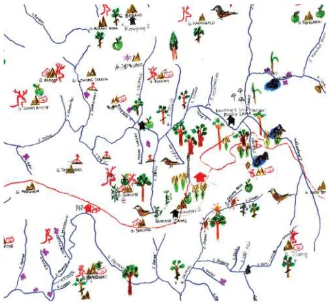
In Rantau Layung, although most informants have good knowledge on what natural resources that are important for them, only a few including the customary leader and hunters can mention where the resources are usually found and put their input to the map. The main resources and special features drawn in the map (Figure 1) were: honey trees (((( ), agarwood ((((((((((( ), cave ((((((((((((((( ), waterfall ((((((( ), salt spring (
(
( ( ( (
( ), rattan garden (((((((((( ), and old villages ((((((((((( ). Hunters were experts mainly in wildlife resources such as deer ((((((((( ), sun bear ((((((((((((( ), monkey (((( ), snake ((((((((((((((((( ), and birds ((((( ).
2. Mului
Figure 1. Part of biodiversity and natural resources distribution map of Rantau Layung Village
[image:7.468.130.360.81.299.2] [image:7.468.126.365.358.579.2]animals (((((((( ), birds (((((((((((( ), bear ((((( ), mountains ((((((( ), lakes (((((((((((((((((((( ), agriculture fi elds
(
(
( ), fruit garden (((((((((((((((((((((((((( ) etc were also provided and drawn on the map (Figure 2). Villagers recognized specifi c sites that seem to be habitat for some endangered species of wildlife
(e.g. sun bear, deer, and hornbills). The GLPF management may consider these sites as key biodiversity areas since most of them are located within and around protected areas. Springs, mountain and riverbanks are among these special areas.
C. Landscape
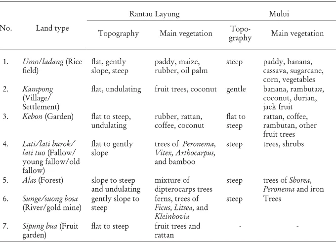
[image:8.468.57.397.277.522.2]There are several types of landscape in Rantau Layung and Mului where communities do their daily activities and collect products as sources of revenue (Table 1).
Table 1. Identifi ed land types in Rantau Layung and Mului, including their
characteristics
No. Land type
Rantau Layung Mului
Topography Main vegetation
Topo-graphy Main vegetation
1. Umo/ladang (Rice
fi eld)
fl at, gently
slope, steep
paddy, maize, rubber, oil palm
steep paddy, banana, cassava, sugarcane, corn, vegetables 2. Kampong
(Village/ Settlement)
fl at, undulating fruit trees, coconut gentle banana, rambutan,
coconut, durian, jack fruit 3. Kebon (Garden) fl at to steep,
undulating
rubber, rattan, coffee, coconut
fl at to
steep
rattan, coffee, rambutan, other fruit trees 4. Lati/lati burok/
lati tuo (Fallow/ young fallow/old fallow)
fl at to gently
slope
trees of Peronema, Vitex, Arthocarpus,
and bamboo
steep trees, shrubs
5. Alas (Forest) slope to steep and undulating
mixture of dipterocarps trees
steep trees of Shorea, Peronema and iron 6. Sunge/suong bosa
(River/gold mine)
gently slope to steep
ferns, trees of
Ficus, Litsea, and
Kleinhovia
steep Trees
7. Sipung bua (Fruit garden)
fl at to steep fruit trees and
rattan
-
-Note: Land type of Sipung bua (Fruit garden) was only identifi ed in Rantau Layung Village
1. Landscape Importance by Use Categories
in an average value of the importance of the landscape types for all use categories (Figures 3 and 4).
Rice fields, 25%
Gardens, 17%
Forest, 16% Village, 14%
Fruits garden, 12%
River, 10% Fallow, 7%
Figure 3. Land types importance (mean value) for all groups in Rantau Layung
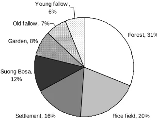
Forest, 31%
Rice field, 20% Settlement, 16%
Suong Bosa, 12% Garden, 8%
Old fallow , 7% Young fallow ,
6%
Figure 4. Land types importance (mean value) for all groups in Mului
Except old women group that valued ‘forest (alas)’ as the most important, all groups ranked ‘rice fi elds (ladang)’ with the highest score (25%) particularly
because of its role as the main source of food. Garden is considered as the second most important (17%) landscape as most villagers plant rattan in their garden which becomes a valuable source of income. In Rantau Layung, forest (alas) is classifi ed
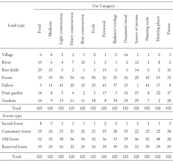
[image:9.468.153.339.120.243.2] [image:9.468.164.326.304.428.2]Table 2. PDM exercise summary of land and forest type importance (mean value) by use categories for all groups in Rantau Layung
Land type Use Category F o o d M ed ic in e L igh t co n str u cti o n H ea vy c o n str u cti o n B o at co n str u cti o n T o o ls F ir ew o o d B as k etr y /c o rd ag e O rn am en t/ ri tu al So u rc e o f in co m e H u n ti n g to o ls H u n ti n g p la ce s F u tu re
Village 6 8 2 2 3 0 1 0 16 1 1 0 3
River 15 6 4 7 10 1 2 1 0 12 1 8 2
Rice fi elds 29 23 3 2 1 3 15 0 1 14 0 0 10
Forest 19 35 30 54 61 50 16 25 26 20 42 53 32
Fallow 3 11 41 20 12 25 41 37 23 1 41 17 8
Fruit garden 14 8 5 4 2 3 17 3 10 23 8 20 17
Gardens 14 9 15 11 11 18 8 34 24 29 7 2 28
Total 100 100 100 100 100 100 100 100 100 100 100 100 100
Forest type
Sacred forest 8 7 3 1 1 1 0 0 1 0 1 1 5
Customary forest 25 26 23 21 20 21 25 28 35 22 20 22 38
Old forest 32 42 38 56 54 42 36 33 39 46 50 48 28
Reserved forest 35 25 36 22 25 36 39 39 25 32 29 29 29
Total 100 100 100 100 100 100 100 100 100 100 100 100 100
In Rantau Layung Village, forest provides main resources for some uses i.e. medicine, house/building as well as boat materials, tools, ornament/ritual, hunting tools and hunting place. It is even considered as the most important land types in the future. Among all forest types, old forest is considered as the most important (Figure 5).
Table 3 shows that forest is the most important landscape in Mului on all use categories including for people’s future, simply because it provides many things for their livelihood. Rice fi eld is the second most important since it guarantees
the availability of food, fi rewood, and culture materials. Rice is the main type of
[image:10.468.52.396.114.433.2]13 24 24 39 0 25 50
Old forest Reserved forest Customary forest Sacred forest
Im p o rt an ce ( % )
Figure 5. Forest types importance (mean value) for all groups in Rantau Layung
Table 3. PDM exercise summary of land and forest type importance (mean value) by use categories for all groups in Mului
Land type Use Category F o o d M ed ic in e L ig h t co n str u cti o n H ea vy c o n str u cti o n B ik e co n str u cti o n T o o ls F ir ew o o d B as k etr y O rn am en t In co m e so u rc e H u n ti n g m ate ri al H u n ti n g p la ce C u sto m ar y F u tu re
Settlement 9 6 1 0 0 0 2 0 1 3 3 0 8 8 Garden 12 9 2 0 0 2 5 0 2 10 0 5 12 12 Rice field 23 9 2 5 4 6 36 0 2 13 0 0 14 16
Young fallow 6 11 5 5 0 3 6 8 4 5 5 6 9 8 Old fallow 10 13 24 10 14 14 13 26 20 10 21 13 11 9
Forest 32 46 59 80 82 75 38 66 67 43 70 65 37 32
Suong Bosa 8 6 7 0 0 0 0 0 4 16 1 11 9 15 Total 100 100 100 100 100 100 100 100 100 100 100 100 100 100 Forest type
Old forest 65 55 48 55 47 45 38 55 59 57 56 51 53 48 Young forest 35 45 52 45 53 55 62 45 41 43 44 49 47 52
Total 100 100 100 100 100 100 100 100 100 100 100 100 100 100
[image:11.468.113.378.87.210.2] [image:11.468.71.417.306.553.2]as more important (70% and 68%; Figure 6) than young forest. This forest provides people with secure source of food and income either today or in the future.
33 68
30 70
0 20 40 60 80
Old forest Young forest
Forest type
Im
por
ta
nc
e
(
%
)
Women Men
Figure 6. Men and women group perceptions (mean value) on forest type importance in Mului
Young forest is less important (30% and 33%) because fewer products come from this forest at present, but it is considered to be more important in the future. Some uses people gathered more from this forest than the old one were light construction, bike construction and tools (Table 3).
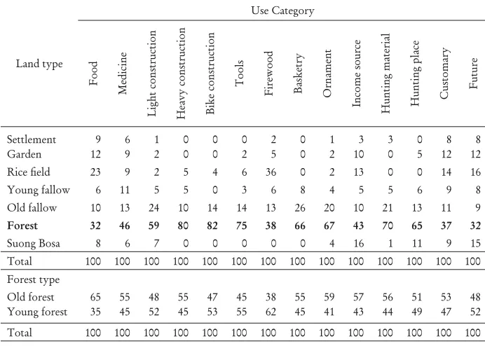
2. Landscape Importance by Distance
How important each landscape compared to the others according to the distance from the settlements was also assessed by using scoring exercises. Rantau Layung people considered rice fi elds as the most important land type, either near (half an
hour walk) or far (more than two hours walk) from the village, as it provides the main source of food to the whole community (Figure 7).
8 9
14 15
17 37
6 10
19 17
16 32
0 10 20 30 40
Ric e fiel
ds Gar
dens Rive
r Fore
st Fallo
w
Frui ts gar
den
Im
p
o
rt
an
ce val
u
e (
%
)
Short distance Long distance
[image:12.468.122.331.133.213.2] [image:12.468.103.344.445.580.2]Garden is the second most important if it is located near by the village so that people can cultivate fruits and rattan to be sold. If it is far from the village, then people suggested forest as the second most important which plays a signifi cant role
in providing many kinds of products such as materials for houses and building as well as boat construction.
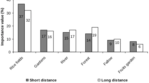
Assuming total area of one certain land type is as extensive as the others, rice
fi eld is considered as the most important land type for most people in Mului (Figure
8). It provided daily needs for food, e.g. cassava, vegetables, etc. This perspective remains the same for both short and long distances. People described that in similar total area, they could collect more food from rice fi eld than from the forest.
However, it is interesting to note that among the other groups only young men perceived forest as the most important landscape. They argued that either in short or long distance the forest will provide them more food and source of income such as fruits, meat and honey. This view is most probably related to their strengths which enable them to walk farther and work harder in the forest than the other groups.
26
16
15 12
9 9
8
6 26
21 19
7 8 8 6
5 10
20 30
m
portance v
a
lue
(%
)
6 5
0
Im
Short distance Long distance
Figure 8. Importance of landscapes (mean value) by distance categories for all groups in Mului
3. Importance of the Source of Products
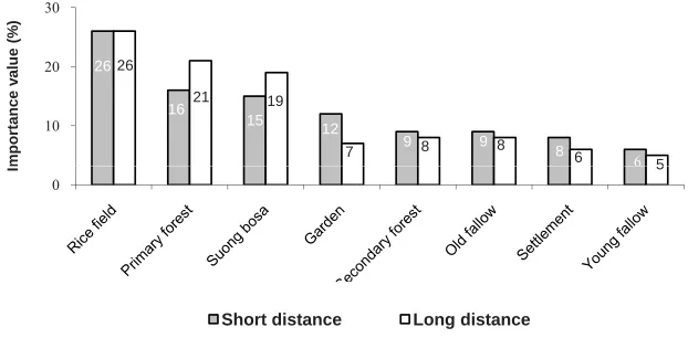
a. The most importance wild, domesticated and bought products
[image:13.468.87.398.299.452.2]plants to be more important than animals. People also considered products from wild resources were more important than those from domesticated and purchased resources. Wild plants (score 32) are important as source of food (vegetables, fruits) and provide valuable products as source of income and other daily needs (basketry, construction, etc.). The second most important category is domesticated products especially rice as the main source of food and rattan as the major source of income. Bought resources are less important as people can still easily fi nd what they need
from the wild and from those they planted and farmed.
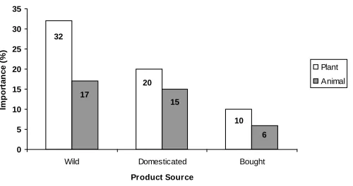
Domesticated and wild plants from the forest are perceived as the most important source for Mului people (Figure 10). Domesticated plants, taken from both wild and bought sources, are important because they provide villagers with food. Wild plants from the forest are important because there are more species of plants available than the cultivated sources. Wild animals either from the forest or other land types are the most important because they are the most available and are free sources.
10 20
32
6 15
17
0 5 10 15 20 25 30 35
Wild Domesticated Bought
Product Source
Im
por
ta
nc
e
(
%
)
Plant Animal
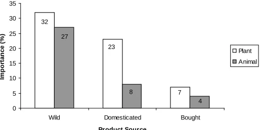
[image:14.468.104.354.289.421.2]7 23
32
4 8
27
0 5 10 15 20 25 30 35
Wild Domesticated Bought
Product Source
Im
por
ta
nc
e
(
%
)
Plant Animal
[image:15.468.121.379.95.224.2]
Figure 10. Product sources importance (mean value) for plants and animals by all groups in Mului
b. The most important plants and animals
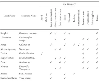
The ten most important plant and animal species that the villagers gained from the forest were listed and ranked for all use categories in Rantau Layung and Mului settlements. People in Rantau Layung ranked sungkai (Peronema canescens) and telien (Eusideroxylon zwageri) as the two most important plants (Table 4) and used as resources for construction, tools, and living in the future. The two most important animals ranked by Rantau Layung people are payau (Cervus unicolor) and telaus (Muntiacus muntjak and M. atherodes) (Table 5) that are perceived as resources for food, income, and future expenditures.
In Mului, sungkai and telien are perceived as the two most important plants (Table 6) which are sources for medicine, construction, tool, fi rewood etc. Payau
Table 4. Ten most important species of plants for all use categories (mean value) in Rantau Layung
Local Name Scientifi c Name
Use Category F o o d M ed ic in e L igh t co n str u cti o n H ea vy c o n str u cti o n B o at co n str u cti o n T o o ls F ir ew o o d B as k etr y O rn am en t/ ri tu al In co m e so u rc e H u n ti n g to o ls H u n ti n g p la ce F u tu re
Sungkai Peronema canescens √ √ √ √ √
Ulin/telien Eusideroxylon
zwageri √ √ √ √ √
Rotan Calamus sp. √ √ √ √ √ √
Meranti/putang Shorea spp. √ √ √ √ √
Durian Durio zibethinus √ √ √
Kapur/sintuk Dryobalanops sp. √ √ √ √ √
Perari Neolitsea sp. √ √ √ √ √ √
Nyarau Elmerrillia
Tsiampacca √ √ √ √ √
Bambu Fam. Poaceae √ √ √
Sambu/mahlaban Vitex vestita √ √
D. Forest
1. Forest Importance: Past-Present-Future
Scoring exercise helps compare the importance of forest in the past (10 years ago), at present, and in the future (next 10 years). For all categories of uses, Rantau Layung people considered forest in the future as the most important for them (43%) as it is the period when useful plants and animals will be more diffi cult to fi nd.
According to these people, the less number of resources available in the forest, the more diffi cult they can be found and the more important they are for local daily
needs. Furthermore, local people thought forest was more important in the past (30%) compared to at present (27%), as it was source of materials for boat, tools, basketry, hunting tools and hunting places. People believed that animal resource was decreasing so that hunting will be more diffi cult in the future and people tend
[image:16.468.50.400.112.393.2]In Mului, the period used to mark the past condition was six years, when people moved from Gunung Janas (old settlement) to current settlement in Tana Rian so that they will easily remember how important the forest.
Table 5. Ten most important species of animal for all use categories (mean value) in Rantau Layung
Local Name Scientifi c Name
Use Category F o o d M ed ic in e L igh t co n str u cti o n H ea vy co n str u cti o n B o at co n str u cti o n T o o ls F ir ew o o d B as k etr y O rn am en t/ ri tu al In co m e so u rc e H u n ti n g to o ls H u n ti n g p la ce F u tu re
Rusa/payau Cervus unicolor √ √ √ √ √ √
Kijang/telaus Muntiacus muntjak and M. atherodes
√ √ √ √ √
Lebah Fam. Apidae √ √ √
Ikan Ichthyofauna √ √
Pelanduk/kancil Tragulus sp. √ √ √
Trenggiling/ayom Manis javanica √ √ √ √
Merak/jue Argusianus argus √ √ √
Beruang Helarctos
malayanus √ √ √
Landak/tetung Hystrix
brachyuran √ √ √ √ √
Ayam hutan/sakan Lophura ignita √ √
Forest is the most important landscape in Mului and it will be more important in the future (49%) compared to at present (33%) and in the past (18%). People described that in the future there will be more benefi t from the forest. People
[image:17.468.71.419.170.463.2]Table 6. Ten most important species of plants for all use categories (mean value) in Mului
Local
Name Scientifi c Name
Use Category F o o d M ed ic in e L igh t co n str u cti o n H ea vy c o n str u cti o n B ik e co n str u cti o n T o o ls F ir ew o o d B as k etr y O rn am en t In co m e so u rc e H u n ti n g m ate ri al H u n ti n g p la ce C u sto m ar y F u tu re
Sungkai Peronema canescens √ √ √ √ √ √ √ √
Telien Eusideroxylon zwageri √ √ √ √ √ √
Putang Dipterocarpaceae √ √ √ √ √ √ √
We Korthalsia sp. √ √ √ √ √
Lomu Canarium littorale √ √ √ √
Durian Durio zibethinus √ √ √ √
Nyarau Elmerrillia tsiampacca √ √ √
Puti Koompassia excelsa √ √ √ √
Nunuk Ficus sp. √ √
Perari Litsea sp. √ √ √
E. Specifi c Resources
Rantau Layung and Mului have many interesting features. Several objects and resources identifi ed important and believed that they can potentially be developed
and managed for economic and specifi c purposes such as for a source of drinking
water, an electric generator and ecotourism which may attract outsiders. However, no proper development has been done for these specifi c potential features in the
area, i.e. objects of ecotourism and hydro-power for electric generator.
Four objects in Rantau Layung, i.e water falls (Sai River and Kepala Luayang),
Riam (Lumbang), cave and Batu utok uwok are potential for ecotourism. The distances from the village are not far, however, path-ways still need to be established to reach them. Several objects that are potential to provide clean water and source of electricity for local community are waterfalls (Kuaro River and Kepala Luayang),
[image:18.468.51.399.115.369.2]Table 7. Ten most important species of animal for all use categories (mean value) in Mului
Local Name Scientifi c Name Use Category F o o d M ed ic in e L igh t co n str u cti o n H ea vy c o n str u cti o n B ik e co n str u cti o n T o o ls F ir ew o o d B as k etr y O rn am en t In co m e so u rc e H u n ti n g m ate ri al H u n ti n g p la ce C u sto m ar y F u tu re
Payau Cervus unicolor √ √ √ √ √ √ √
Telaus Muntiacus muntjak
and M. atherodes √ √ √ √ √ √
Juwe Argusianus argus √ √ √
Bilaomban Copsychus
malabaricus √ √
Sakan Tragulus javanicus √ √ √ √
Pelanuk Lophura ignita √ √ √
Biwang Helarctos
malayanus √ √ √
Lisio Rollulus rouloul √ √ √ √
Tetung Hystrix brachyura
and H. crassispinis √ √ √ √ √ √
Pengulor Bird species √
Three objects in Mului, i.e. waterfall, bengenget stone and cave are among the most potential sites for ecotourism. They are located relatively near the settlement, save and easy to reach. They offer some interesting features for visitors such as scenery of waterfall, fresh water for bathing in natural pool, underground adventures/caving and experience to observe thousand of bats in their natural habitat.
F. Implication to Policy on Protection Forest Management
[image:19.468.72.420.114.421.2]The new paradigm “Community Based Forest Management” should also be implemented in managing this protection forest. Village and customary institutions that still exist in the area are potential to be used and should be strengthened to involve the communities in arranging, utilizing and conserving the forest. These institutions can also be used as media for socialization and/or extension about the legal status of GLPF, since the extension worker from forestry services are usually limited in number. Peoples’ recognition of the high importance level of the protection forest resource, indicates that the awareness of the communities in gathering and utilizing the forest resource wisely, especially non timber forest product, would increase.
IV. CONCLUSIONS AND RECOMMENDATIONS
A. Conclusions
In Rantau Layung, the most important land type was rice fi eld, whereas in
Mului, is forest. There were 13 use categories of landscapes in Rantau Layung, among other are food, medicine, constructions and source of income. Whereas, in Mului there were 14 use categories. People in Rantau Layung and Mului ranked plants to be more important than animals. People also considered products from wild resources to be more important than those from cultivated and bought resources.
Communities living in both settlements considered forest as the most important in the future compared to the other periods (in the past and at present). They also suggested that sungkai and telien were the most important plants of forest while payau (Cervus unicolor) and telaus (Muntiacus muntjak) were the most important animals. People used the important wildlife mainly for food and source of income.
Specifi c natural resources in Rantau Layung and Mului such as waterfall,
cave, spring, etc. including culture and local wisdom are potential to be developed to support local livelihoods. A management model of the GLPF with active participation of the local stakeholders may be developed to accommodate the needs to conserve the forest while recognizing the rights of the people live in and benefi t
from the forest.
B. Recommendations
As forest resources are of a high importance for local people, the protection forest management unit should ensure community involvement in the management. Some potential specifi c resources in the areas need to be developed to improve local
REFERENCES
Boissiere, M., M. van Heist, D. Sheil, I. Basuki, S. Frazier, U. Ginting, M. Wan, B. Hariadi, H. Hariyadi, H.D. Kristianto, J. Bemei, R. Haruway, E.R.Ch. Marien, D.P.H. Koibur, Y. Watopa, I. Rachman dan N. Liswanti. 2006. Pentingnya sumberdaya alam bagi masyarakat lokal di Daerah Aliran Sungai Memberamo, Papua, dan implikasinya bagi konservasi. Journal of Tropical Ethnobiology 1: 76-95.
Desa Rantau Layung. 2005. Daftar isian potensi desa tahun 2005. Rantau Layung. Pemerintah Kabupaten Pasir.
Desa Swan Selutung. 2002. Profi l Desa Swan Selutung, Kecamatan Muara Komam,
Kabupaten Pasir, Kalimantan Timur. Departemen Dalam Negeri Republik Indonesia.
Murniati, M. Padmanaba and I. Basuki. 2008. Forest resources utilization value of the communities living in and around Gunung Lumut Protection Forest, East Kalimantan. Journal of Forestry Research 5:147-171.
Payne, J., C.M. Francis, K. Phillipps, and S.N. Kartikasari. 2000. Panduan lapangan mamalia di Kalimantan, Sabah, Sarawak & Brunei Darussalam. The Sabah Society-WCS Indonesia Program. WWF Malaysia.
Saragih, B. 2004. Nilai ekonomi kawasan Hutan Lindung Gunung Lumut bagi masyarakat dan pemerintah Kabupaten Pasir. A paper presented in Tropenbos Workshop in Balikpapan, 1-2 December 2004.
Sheil, D., R.K. Puri, I. Basuki, M. van Heist, M. Wan, N. Liswanti, Rukmiyati, M.A. Sardjono, I. Samsoedin, K. Sidiyasa, Chrisandini, E. Permana, E.M. Angi, F. Gatzweiler, B. Johnson, and A. Wijaya. 2003. Exploring biological diversity, environment and local people’s perspectives in forest landscapes: methods for a multidisciplinary landscape assessment,. CIFOR. Bogor. Sheil, D., R.K. Puri, M. Wan, I. Basuki, M. van Heist, N. Liswanti, Rukmiyati, I.
Rachmatika and I. Samsoedin. 2006. Recognizing local people’s priorities for tropical forest biodiversity. Ambio 35 (1): 17-34
Tropenbos Kalimantan Program. 2005. Proposal of Gunung Lumut Biodiversity Assessment. Loka Litbang Satwa Primata in cooperation with TBI Indonesia Programme. Balikpapan.