Washington Uses
Spatial Planning
to Honor its
Paciic Coast and
Offshore Waters —
Past, Present
and Future
The Washington State Paciic Coast and offshore waters are diverse in both their natural re-sources and how the people who live and work there use them. The area’s rich inshore and offshore waters teem with commercially valuable inish and shellish, marine mammals, and rare deep-sea corals. The people who call this area home include several federally recognized Tribes, marine users ranging from commercial ishermen to surfers, and private citizens. All have a long-standing relationship with and reliance on these natural resources. It is not surprising that they also have long played an active role in the management of these waters. Their goal? Protect the natural resources they depend upon and appropriately manage increased human activity.
MARINE SPATIAL PLANNING
I
n 2002 and 2007, proposals for renewable energy fa-cilities off the Washington Paciic coast became the driver for implementing marine spatial planning (MSP) for these waters. When the industry leader of the 2007 proposal shared his vision of the ocean in 2050, crab isher-man Dale Beasley said: “There’d be no room for anything else in the ocean . . . our legislators said absolutely that is not the vision for this state!” The response was the state’s 2010 “Marine Waters Planning and Management” law, spearheaded by state Senator Kevin Ranker. That law would outline a way to both strategi-cally plan for new uses while protecting existing uses in state waters. While the initial renew-able energy proposals did not come to fruition, the MSP pro-cess continues today — driven both by the law and by the need to consider possible future development in these waters.Planning has started with the Paciic Coast area. Boundaries — based on agency, stakeholder and public input — include state waters out to 3 nautical miles and federal waters out to 700 fathoms deep (4200 feet).
WASHINGTON PACIFIC COAST PLANNING AREA
W
ashington’s Paciic Coast has a history of spatial planning and community-led initiatives to manage its waters. There’s the Olympic Coast National Marine Sanctuary “Area to be Avoided,” which guides ships away from sensitive marine environments. A second tool, the Crabber Towboat Lane Agreement, reduces conlicts between crab ishermen and towing vessels. Both tools successfully balance protection of natural resources with appropriate human uses.Washington’s four Coastal Treaty Tribes — the Hoh, Makah, and Quileute Tribes and the Quinault Indian Nation — manage shellish and inish in tribal “usual and accustomed areas” in accordance with tribal law. Washington Paciic Coast municipalities and counties have community-developed Shoreline Master Programs that man-age shoreline lands and waters out to 3 nautical miles. Paciic Coast counties have longstanding, active Marine Resources Committees — citizen volunteers promoting stewardship of coastal and marine resources. The communities of the Paciic Coast are dedicated. They help lead the management of Paciic Coast resources.
In public workshops on
the marine spatial plan,
stakeholders repeated:
“protect and preserve
existing sustainable
uses.” These exact
words were integrated
into the plan’s goals
W
ashington State’s Paciic Coast and offshore waters are a study in contrasts. This region has low sandy shorelines in the south and rocky elevated shorelines in the north. It hosts diverse marine life in its waters and a migratory pathway for millions of sea birds. That’s the natural environment.But, who are the people who live, work and play there? These are individuals who have relied heavily on the natural resources for their living and/or as part of their history and culture. Four Coastal Treaty Tribes – the Hoh, Makah, and Quileute Tribes and the Quinault
Indian Nation — as well as the Shoalwater Bay Tribe call this coast home. Under 19th century treaties with the federal government, the Coast-al Treaty Tribes have the right to take 50 percent of all naturally occurring inish and shellish in tribal “usual and accustomed areas,” and they are co-managers of these resources. They ish both for subsistence and employment. In oth-er communities, commoth-ercial ishoth-ermen target Dungeness crab, whiting, albacore and other species, while aquaculturists farm clams, oys-ters and geoducks. Offshore, cargo ships travel through these waters and service Paciic Coast ports including Grays Harbor and Port Angeles. Closer to shore, residents and visitors alike enjoy recreational ishing, suring and other activities.
These natural resource-dependent industries have ebbed and lowed with economic and environmental change, yet they have deined the culture and traditions of many Paciic Coast communities.
During the public scoping process for the marine spatial plan, stakeholders voiced their sentiment loud and clear.
The plan should not just preserve Paciic Coast and off-shore natural resources but must “protect and preserve existing sustainable uses.” Agency leads agreed and incorporated this wording into the plan’s goals and ob-jectives. This goal, which is now integral to the planning process, honors the coast — past, present and future.
The MSP law and process became, and continues to be, an opportunity for the state and coastal communities to work together to plan for Paciic coastal and offshore wa-ters comprehensively and with an eye toward the future.
T
he Washington Coast MSP process will result in a non-regulatory marine spatial plan for Pacif-ic coastal and offshore waters that is intended to ensure a resilient and healthy marine ecosystem to support sustainable economic, recreational, and cultur-al opportunities for coastcultur-al communities, visitors and future generations.The Washington Department of Ecology, working closely with Washington’s Department of Natural Resources and Department of Fish and Wildlife, is leading the MSP
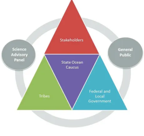
Committees and stakeholders including ishermen, shell-ish farmers, recreational users, conservation interests and many others. Washington Sea Grant, another important player, coordinates a Science Advisory Panel and many of the state-organized outreach activities. Other key partners who provide both professional expertise and irsthand experience include the Coastal Treaty Tribes and environ-mental organizations. All of these participants — whether government agencies or stakeholders — are important both for their role in plan development and because they will use the inal plan once completed.
P
lanning for the Paciic Coast began in earnest in 2012 with the allocation of $2.1 million in state funding and an expected completion date of late 2016. Actions to date include:• “Pre-planning,” including deining the plan area and management goals and objectives
• “Understanding impacts” tasks, including conducting numerous mapping, research, and assessment projects with examples that include:
— A Sector Analysis, identifying current and future projections for the shipping, ishing, aquaculture, recreation and tourism, and renewable energy sectors; and
— An Ecosystem Assessment with ecological, social
W
hat lies ahead? The inal plan will identify potentially suitable areas for new uses as well as those areas to avoid. It will include maps of areas with high potential for renewable energy and minimal potential for conlicts with existing uses or sensitive environments. Currently, the state is using GIS tools to assess the potential spatial interactions between existing and possible new uses. It is also drafting maps showing the intensity of existing uses and total num-ber of uses — maps the public will have the chance to review and vet.Washington’s MSP law requires that the plan include an adaptive management strategy. As new information on the marine environment and speciic projects arises, the state must consider the need to update the plan.
Last, once the state adopts the marine spatial plan, it will use information and analysis from the MSP process to develop a Geographic Location Description — a coastal management tool that allows states to list the federal licenses or permits for activities in a deined area of federal waters that are automatically subject to state re-view because of the potential impacts of those activities on state coastal resources and uses.
Stage 1: Pre-Planning
FALL 2012- JUNE 2013
• Deine the plan area
• Map uses & resources
• Identify criteria for adoption into WA CZMP
• Deine management goals & objectives
Stage 2: Understanding Impacts
JULY 2013- JUNE 2015
• Complete SEPA scoping
• Sector Analyses:
Understand requirement of each use & predict future uses/needs
• Ecosystem Assessment
• Economic Analysis
• Use Analysis:
Identify conlicts and compatibilities (fall 2015)
Stage 3: Developing the Plan
JUNE 2015- DEC. 2016
• Select and evaluate Management Strategies and Plan Scenarios
• Develop spatial plan and draft/inal EA/EIS (SEPA) and Adapt MSP (ongoing)
➧
➧
➧
Stakeholder involvement, tribal consultation, government coordination and public input throughout process
GRAPHIC COURTESY OF WASHINGTON DEPARTMENT OF ECOLOGY
TABLE ADAPTED FROM WASHINGTON DEPARTMENT OF ECOLOGY
Lessons Learned from
Washington State
W
ashington State’s MSP process has not yet concluded. Nevertheless, it hasgenerated lessons learned that can continue to inform Washington practitioners as they inalize and implement their plan and be equally useful for other MSP and coastal management practitioners throughout the U.S. and the world. For a more complete description of these lessons, please visit the website www.crc.uri.edu/initiatives_page/msp/
Understand Where You’re
Starting From
Which planning efforts worked and which did not work in the past? Why? How were successful decisions made? Who was involved? Learn from and build on past successes and avoid repeating the same mistakes. These are questions practitioners need to ask during the initial phase of developing a marine spatial plan.
Manage Expectations
Know what is realistic and help others understand. Marine spatial planning can be complex. Outline realistic goals and a process and commit to clear and transparent communication. Make sure more than one person is delivering the communication, and that they are communicating the same message and communi-cating it widely.
Be Flexible and Adapt to
Keep Your Driver Compelling
If a planning driver stops being relevant — for exam-ple, if the driving issue becomes less pressing or ceases to be a problem — stakeholders may drop out of the process. They may ask, “What’s in it for me?” If this happens, talk with stakeholders. Learn their priori-ties. From that, identify another compelling issue that its within the scope of the planning process and can become the new driver for the MSP effort. If no alter-nate driver emerges, complete tangible stand-alone products that will be useful to stakeholders. Keep your stakeholders in the game!
This document was produced in 2016 by the Coastal Resources Center and Rhode Island Sea Grant College Program at the University of Rhode Island Graduate School of Oceanography. It is one of a series of products sharing lessons learned from the practice of marine spatial planning in the United States and abroad. These products include the “Case Studies in Marine Spatial Planning Report Series” edited by Jennifer McCann. They are part of our ongoing research and capacity-building initiative to strengthen the network of MSP and coastal management practitioners.
For further information, and for access to other documents including technical reports summarizing