MPA’s and Poverty Alleviation
An Empirical Study of 24 Coastal Villages on
Mainland Tanzania and Zanzibar
February 2004
ACRONYMS
CHICOP Chumbe Island Coral Park Ltd.
JCBA Jozani-Chwaka Bay Conservation Area MIMP Mafia Island Marine Park
MPA Marine Protected Area
MPRU Marine Parks and Reserves Unit, Government of Tanzania MBCA Menai Bay Conservation area
MICA Misali Island Conservation Association MICP Misali Island Conservation Program
TCZCDP Tanga Coastal Zone Conservation and Development Program WWF World Wide Fund for Nature
IUCN The World Conservation Union
ACKNOWLEDGMENTS
This study was conducted for the World Bank under the guidance of Indu Hewawasam, Senior Environmental Specialist, and Paavo Eliste, World Bank Young Professional. The primary authors of this report are Yolanda León, James Tobey, Elin Torell, Rose Mwaipopo, Adolf Mkenda, Zainab Ngazy, and Farhat Mbarouk. We appreciate the work of twenty-four field assistants who conducted the household and focus group interviews. Appreciation is also
TABLE OF CONTENTS
ACRONYMS... i
ACKNOWLEDGMENTS... i
List of tables... 3
LIST OF FIGURES... 4
INTRODUCTION... 5
Background... 6
Poverty in Tanzania... 6
Tanzania’s Coastal Resources... 7
Marine Fisheries... 8
Coastal Management Issues... 9
Tanzanian Government Commitment... 10
MPAs as a Strategy of Marine and Coastal Management... 11
Alternative Livelihood Strategies... 12
MPAs in Tanzania... 13
Methods... 15
Study Sites... 15
Tanga Coastal Zone Conservation and Development Program 18 Mafia Island Marine Park 19 Kilwa District 22 Menai Bay Conservation Area 23 Jozani-Chwaka Bay Conservation Area 24 Misali Island Marine Conservation Area 26 Household and focus group surveys... 28
Results... 30
Village and Household Characteristics... 30
Household demographics 31 Education 31 Health 34 Drinking Water 35 Sanitation and Public Services 37 Cooking fuel 37 Productive Activities... 38
Food Security... 42
Savings and Credit... 45
Material lifestyle... 46
Social Capital... 54
Fishery Characteristics... 56
MPA Awareness... 72
MPA Involvement... 73
Impact of MPAs... 74
DISCUSSION... 88
REFERENCES... 91
LIST OF TABLES
Table 1. Selected country information: Tanzania... 6
Table 2. Key facts about the study sites... 15
Table 3. Characteristics of protected areas in the selected study sites... 15
Table 4. Villages and number of households surveyed for this study... 16
Table 5. Total number of male and female headed households surveyed in each field site... 29
Table 7. Perceptions of priority problems in the village... 30
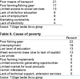
Table 8. Cause of poverty... 31
Table 9a. Highest level of education achieved by adults... 32
Table 9b. Highest level of education achieved by adults according to sex... 32
Table 10. Percent literacy of adults1 in surveyed households... 33
Table 11. Primary school enrollment ratios (children aged 7-13 years)1... 33
Table 12. Percent of households affected by sickness or injury within the past 12 months... 34
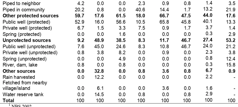
Table 13. Source of drinking water ... 35
Table 14. Water problems in villages... 36
Table 15. Type of toilet used by household... 37
Table 16. What is the principal energy source for cooking?... 37
Table 17. Main economic activity declared by head of household)... 38
Table 18. Resource-based household subsistence and employment activities... 39
Table 19. Major problems facing fishers as perceived by heads of household... 40
Table 20. Major problems facing farmers as perceived by heads of household... 40
Table 21. Where do you sell your products?... 41
Table 22. How do you purchase and sell your products?... 41
Table 23. How is fish stored before it is sold?... 41
Table 24. Percentage of households with three meals a day... 42
Table 25. Household perceptions on food situation compared to five years ago (percent)... 42
Table 26. Over last 12 months, reason the household failed to get daily normal diet?... 43
Table 27. Most important factors affecting household income that could lead to famine... 43
Table 28. During period of insufficient food, how did the household cope with the situation?. 44 Table 29. How does the household store its surplus (i.e. money or produce)?... 45
Table 30. Where have you borrowed money from?... 45
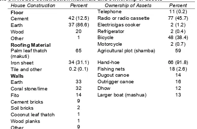
Table 31. House construction materials and ownership of assets... 46
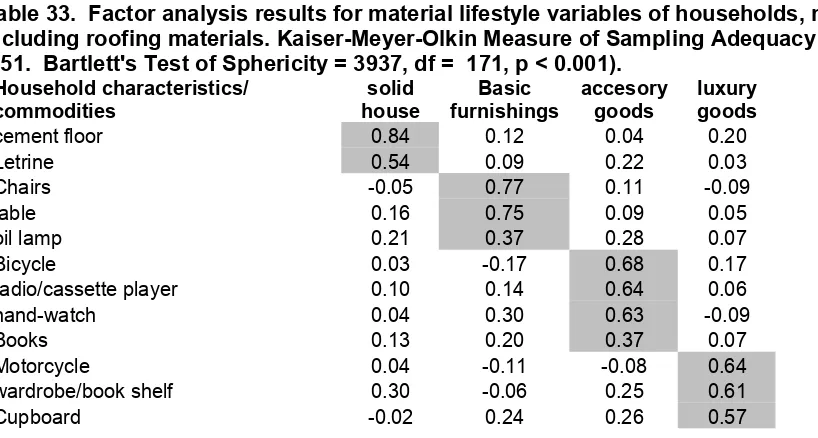
Table 32. Factor analysis results for material lifestyle including roofing materials. ... 48
Table 33. Factor analysis results for material lifestyle not including roofing materials. ... 48
Table 34. Linear regression of village and household variables and material lifestyle ... 52
Table 35. Linear regression of village and household variables and material lifestyle (no roof) 53 Table 36. Group membership and importance... 54
Table 37. Benefits of joining groups... 54
Table 38. Can any member of the household can influence decisions in the village?... 55
Table 39. In general, how do you view trust among villagers?... 55
Table 40. Marine species harvested... 56
Table 41. Factor analysis results for fishers. ... 60
Table 43. Have you ever heard anything about marine parks?... 72
Table 44. Where did you get information on the MPA?... 72
Table 45. What are the objectives of marine parks?... 73
Table 46. How have you been involved in the MPA? (percentages)... 73
Table 47. How have you been involved in MPA income generating components?... 74
Table 48. Has the MPA placed restrictions over marine resource use?... 74
Table 49. Comparison of selected variables in project (p) and control (c) sites... 75
Table 51. What do you dislike about MPA’s?... 76
LIST OF FIGURES Figure 1. Location of study sites... 17
Figure 2. Household source of drinking water... 36
Figure 3. Frequency of seaweed farming... 40
Figure 4. How often did your household fail to get normal diet during the past 12 months?... 43
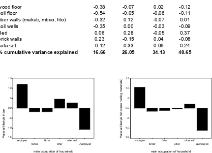
Figure 5. Material lifestyle indices by main economic activity of the head of household... 49
Figure 6. Mean scores of material lifestyle components by gender of the head of household... 49
Figure 7. Material lifestyle index by literacy condition of the head of household... 50
Figure 8. Material lifestyle score by MPA/region... 50
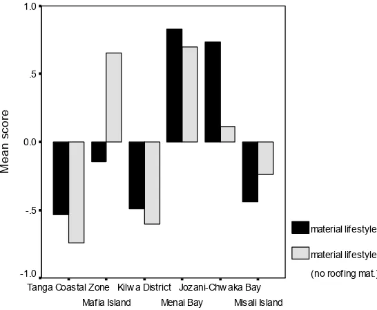
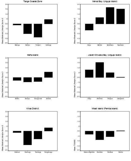
Figure 9. Mean material lifestyle score 2 by MPA / Region and village... 51
Figure 10. Frequency of marine species commonly harvested by households... 58
Figure 11. Fishing platforms used an their frequency... 58
Figure 12. Ownership of fishing platforms and their frequencies... 59
Figure 13a. Fishing gears used and their frequency... 59
Figure 13b. Ownership of fishing gears and their frequencies... 60
Figure 14. Mean factor dagaa scores by villages in study areas... 64
Figure 15. Mean factor reef scores by villages in study areas... 65
Figure 16. Mean factor pelagic shallow scores by villages in study areas... 66
Figure 17. Mean foot component by villages in study areas... 67
Figure 18. Mean shark component score by villages in study areas... 68
Figure 19. Mean scores for pelagic deep by villages in study areas... 69
Figure 20. Mean scores for SCUBA by villages in study areas... 70
Figure 21. Mean scores for beach component by villages in study areas... 71
Figure 22. Mean MPA impact scores by MPA and village... 80
Figure 23. Mean impact of MPA on employment... 82
Figure 24. Mean impact of MPA on household involvement in coastal resource decisions... 83
Figure 25. Impact of MPA on local culture and traditions... 85
INTRODUCTION
The purpose of this study is to provide baseline information on a wide variety of social and economic variables in coastal areas of mainland Tanzania and Zanzibar where there are existing or potential future Marine Protected Areas (MPAs). In particular, it explores the links between the coastal and marine environment and poverty with the goal of identifying long-term
management options for poverty alleviation through community-driven coastal and marine management. Data sources for the study comprise an extensive review of literature, key
informant interviews, household surveys and focus group meetings in 24 villages from six coastal sites.
Attention to the links between the environment and poverty has grown in recent years. The 2002 World Summit on Sustainable Development in Johannesburg, South Africa, resulted in an
international consensus that for sustainable development to be successful it needs to be defined by the simultaneous objectives of poverty alleviation and conservation Since then, environmentally sustainable development and poverty alleviation have become focal points of international aid and development assistance. In Tanzania, the importance of sustainable environmental
management and poverty reduction is articulated in the government’s Poverty Reduction Strategy Paper and Development Vision 2025. These documents highlight the heavy dependence of the poor in Tanzania on the environment and natural resources for their livelihood and therefore emphasize the need to mainstream environmental sustainability into poverty reduction efforts. MPA management as an approach to coastal and marine conservation has also grown rapidly in Tanzania and worldwide. Brown et al. (2002) report that there are approximately 1,300 MPAs worldwide. Francis et al. (2002) identify some 28 MPAs in East Africa. Support for protected area management in Africa was recently reconfirmed in July 2003 when heads of state amended the African Convention on the Conservation of Nature and Natural Resources to promote the establishment of community-based protected areas and address gaps in the conservation of biodiversity. Boersma and Parrish (1999) have reviewed the reasons for the establishment of MPAs and find that almost all aim for some form of protection of local marine resources. In addition, conservation of biodiversity, maintenance of fisheries and sustainable tourism
development are frequent reasons for designation. MPAs have multiple objectives, but all are in effect related to a desire to maintain or increase ecosystem values.
The links between poverty and MPA management have not previously been analyzed
systematically across MPA sites in Tanzania. A better understanding of the status, issues, and threats to the coastal and marine environment and the direct and indirect links to human welfare is essential for policy decisions to manage natural resources in a sustainable and effective manner.
BACKGROUND
Poverty in Tanzania
Addressing the issues associated with poverty and sustainable use of the coastal and marine environment is critical in Tanzania. Despite significant economic growth in recent years, most rural coastal communities are still very poor and dependent on common property natural resources—the sea, intertidal marine systems, and forests—for livelihood.
We define poverty broadly to include income and non-monetary dimensions of poverty. This highlights the idea that development must be people-centered to be sustainable and include the human dimensions of development such as participation in decision making,health, education, vulnerability, food security, cooperation, trust, and equity. Poverty is a multidimensional phenomenon with different sets of indicators illustrating different factors that exclude people from a minimum acceptable way of life within their own society. By almost any poverty measure, Tanzania ranks low compared to other countries (Table 1).
Table 1. Selected country information: Tanzania
Population (2002 census) 34.5 million
Life expectancy at birth (2000) 44
Under-5 mortality rate (2000) 149 per 1000
Gross national income (2001) US$270/capita
Rural population below the poverty line (1993) 49.7%
Ranking on the Human Development Index 151 (out of 173) Source: 2003 World Development Report, World Bank, 2003.
The National Bureau of Statistics conducted a household budget survey in 2000-2001 (NBS 2002). The survey results confirm that income poverty is high and social indicators show high levels of non-income poverty. Nationwide only 12% of households have electricity (only 2% in rural areas), 6% have a bank account, 25% have modern walls, and for 45% of households, drinking water is more than 1 km away. One quarter of Tanzanian adults have no education and 29% can neither read nor write. Women are about twice as likely as men to have no education. The survey also revealed that poverty remains overwhelmingly rural—87 percent of the poor live in rural areas. The percentage of rural population in food poverty and basic needs poverty
Tanzania’s Coastal Resources
The Tanzanian coastline runs approximately north-south and is dominated by three large offshore islands: those of Pemba, Zanzibar1 and Mafia. Among the countries of Eastern Africa, Tanzania has the greatest reef area (3,580 km 2 ; Spalding et al., 2001). There are fringing and patch reefs along much of the mainland coast and the offshore islands.
Misali Island, just west of Pemba, has been singled out for having some of the highest recorded coral cover, and high species diversity. Chumbe and Mnemba islands off Zanzibar have been similarly singled out as offshore islands with diverse and well-protected reefs. Mafia Island has extensive reefs, particularly in the south, many of which remain in good condition. Likewise there are many reefs around the Songo Songo Archipelago in good condition, especially those furthest from the mainland.
There are mangrove forests in most river mouths and seagrass ecosystems are widespread, particularly in the shallow waters around the Mafia and Songo Songo Archipelagos. The Rufiji delta supports the largest single mangrove forest in eastern Africa, covering 53,000 hectares. Mangroves and shallow coral reef resources represent accessible open access resources, which are highly diverse, productive, and provide an important resource for poor people living on the coast.
There are over 43,000 marine fishermen in Tanzania predominantly operating in shallow waters using traditional canoes, outrigger canoes, and dhows (Jiddawi and Ohman, 2002). Fish caught by small-scale fishers provide a high percent of the animal protein consumed in coastal communities. The fish from rural communities also take part in fulfilling a growing need for fish protein in the expanding urban centers. Fishing is practiced throughout the year but the peak season is during the Northeast monsoon (November to April) when the ocean is calmer and clearer (TCMP, 2003). When the sea is turbulent, fishermen spend their time repairing fishing gear and cultivating their farms.
The coastal population of Tanzania is about 23 percent of the national population and is mostly concentrated in the urban areas of Tanga, Zanzibar, Dar es Salaam and Mtwara. In the urban areas, rapid population growth combined with poor management of the coastal area has lead to the rapid and extreme degradation of coral reefs, shoreline change, and deforestation. In the vicinity of high population areas, shallow reefs are almost completely destroyed. The large urban demand for resources from the coast also exerts pressure on the natural environment along the entire coast. For example, the urban demand for timber, poles for construction and charcoal for fuel, ornamental shells, lobster, crabs, octopus and all types of fish products is a driving force of growing resource exploitation in rural areas.
Most of the coast is relatively isolated with very poor infrastructure in terms of roads,
communications, electrical service, and ports. For communities directly on the coast or located on small islands, fishing is the primary activity. Overfishing and destructive fishing is a problem everywhere. Inshore fishing effort has roughly doubled in less than 20 years. A report published in August 2003 on the state of the coast of Tanzania proved a comprehensive overview of the human and environmental condition of the coast of Tanzania (TCMP, 2003). We know with considerable certainty that the inshore fishery of mainland Tanzania and Zanzibar is
1
overexploited and that shallow reefs are degraded. Fish abundance in most locations has declined significantly in the last decade, while fishing effort has increased. With essentially no deep-sea fishery, the pressure exerted on fragile inshore coral reef ecosystems is persistent.
Marine Fisheries
The marine fisheries in Tanzania are mostly artisanal and are located along a relatively narrow strip along the coast. This limitation is due to the limited range of the traditional vessels and the narrow continental shelf. The continental shelf typically extends to about 4k offshore with the exception of the Zanzibar and Mafia channels, where the shelf extends form 60km. Nevertheless, this nearshore fishery is extremely important to coastal communities, both as a direct source of food for households and as a source of income. As with many other tropical countries, the fishing community in Tanzania is comprised mostly of individuals with very little alternative income-earning capacity.
Fishing activities also take place along the intertidal zones during low spring tides especially by fisherfolk who cannot afford vessels or gear. They usually collect sea cucumbers, shells, and octopus by hand or with the assistance of a stick. Historically, shells were exported in bulk from Zanzibar.
Marine fisheries are an important source of income for many groups besides fishers. These include all those involved in boat construction and repair, and marketing and sale of fish products. The middlemen and traders play an important role in the artisanal fishery in providing an opportunity for those fishermen who cannot afford to buy gear or vessels. A middleman usually owns the expensive gear and vissels, such as the seine or gill net and boats or dhows. He partners with the fishermen such that the money obtained from the catch is divided into three parts: one to the middlemen, one for boat and gear maintenance and one for all the fishers on the boat. And, besides local consumption, fisheries provide foreign currency through
international export products like sea cucumber, shells, live lobsters, crabs, squid, octopus, sardines and shark fins.
According to Jiddawi and Ohman (2002), there has been an increase in the number of local fishermen as well as an increase in the number of migrating fishermen who travel from their homes to camp and fish in other areas. This movement locally known as dago is an important characteristic of many fisheries in Tanzania. It has resulted in a localized increase of fishing effort in some areas during certain periods of the year and has been the cause of fishery conflicts with local communities. It also poses particular problems for the management of fisheries, and for the adoption of community based approaches to management. Fishing activities are strongly influenced by the monsoon winds which are seasonally reversing winds, with most fishing ocurring during the northeast monsoon (kaskazi) which prevails from november to February and is characterized by higher air temperatures and weaker winds.
fitted with outboard or inboard engines. Most of these vessels lack cooling and freezing facilities so fishing is limited by both time and distance, thus fisherfolk continue to fish the same grounds as were fished by earlier generations.
Fishery target species are very numerous, especially in terms of fish species. The number of marine fish species in Tanzania is estimated to be over 1000, out of which about half may be utilized as food or for commercial purposes (Jiddawi and Ohman 2002). The lobster fishery is especially important for tourist hotels and restaurants, although some lobsters are also exported to Portugal, UK and Hong Kong (Jiddawi and Ohman 2002). The seacucumber trade is a
comparatively big industry in Tanzania. Twenty two species are traded, with Holothuria scabra
and H. nobilis being the most important. The product is gutted, boiled and dried before being
exported ot the Far East. Virtually no sea cucumbers are consumed locally. More than 150 species of sea shells are collected by fishermen in Tanzania for food and to be sold as curios. Artisanal fishing for octopus is also a highly important economic and subsistence activity for local coastal communities in East Africa, and is extensively practiced along the coast of Tanzania (Guard and Mgaya 2002). Octopi (pweza) are collected from intertidal reef flats and subtidal inner reefs for both local and inland consumption and for export to European and Far Eastern markets (Darwal 2000). Traditionally, fishing for octopus has been dominated by women and children and is important for being one of the few sources of income for this gender group (Guard and Mgaya 2002). In recent years, however, men have become increasingly involved with octopi fisheries due to a rise in demand and greater income opportunities (Guard and Mgaya 2002). Outside buyers, who export octopus, now operate along the coast, and using specially
comissioned boats to take fishers to fishing sites also pay premium prices for the catch. Mafia island and Tanga have octopus processing plants which involve considerable number of fisherfolk and have created an overexploitation of the resource (Jiddawi and Ohman 2002). The majority of octopus is sold fresh or iced with some going to the local restaurant industry. The remaining is salted and dried and later exported to Kenya, the Middle East, and Spain. Octopus is also an important component on tourist restaurant menus.
Coastal Management Issues
Much of the pressure on fisheries and degradation of reef ecosystems in Tanzania has been caused by destructive fishing methods. By far the most destructive type of fishing is the use of dynamite.
Dynamite fishing was once widespread, but its use has been reduced drastically throughout the country. Dynamite fishing has been practiced in Tanzania for over 40 years. Each blast of dynamite instantly kills all fish and most other living organisms within a 15-20 m radius and completely destroys the reef habitat itself with a radius of several meters. With numerous blasts occurring daily on reefs all over the country, over a period of many years, the cumulative effect has been devastating. Before 1995, Mafia Bay was reported to be like a “war zone” with blasts going off every hour. A survey in Tanga region has shown that dynamite fishing was responsible for the damage beyond recovery of 10 percent of coral reefs in the region and 70 percent showed significant damage but could recover if protected.
1998). One square kilometer of reef in poor condition, on the other hand, produces no more than 5 metric tons of fish per year, barely enough to feed 100 people.
The use of small mesh seine nets to capture fish on the bottom and around reefs is almost as destructive as the use of dynamite. The nets are weighted and dragged through the reef flat or are pulled around coral reefs. Dragging them over the reef flat unavoidably damages coral and other marine life. Some techniques additionally involve beating and smashing coral colonies with poles to frighten fish into the net. The small-mesh size of seine nets results in the capture of many juveniles. Capture of juvenile fish, when conducted intensively in nursery areas, results in
depletion of fish stocks, alteration of species composition, loss of species diversity, and disruption of food webs.
Destructive fishing methods are illegal, but continue to be used due to lack of enforcement and competition for marine harvests. Shells, sea cucumbers, and lobsters are all over exploited. Nesting populations of marine turtles have been declining rapidly due to incidental turtle catch, hunting, poaching of turtle eggs on the beach, and loss of nesting beaches. In some areas of mainland Tanzania (especially the Rufiji Delta area and Bagamoyo) the commercial shrimp trawling fishery degrades or destroys seagrass, destroys marine turtles, and depletes fish stocks and diversity through incidental bycatch.
Extraction of living coral for use in building and in conversion into lime for cement is another highly destructive activity that is also widespread along the entire coast. Live and dead corals are extracted from reefs using pick axes, crowbars and other implements. The corals are brought ashore where they are piled into kilns and burned to produce lime for local building and trade. It is prevalent in Lindi and Mtwara regions and in Dar es Salaam. In 2000 it was estimated that 1,500 tons of coral were being mined every year from the Mikidani Bay area in southern
Tanzania alone. The damage to shallow inshore reefs in such a case is immense. On Mafia Island, coral mining was ranked third as an income-generating activity, in terms of the numbers of people involved in the early 1990’s (Dulvy et al., 1995).
Other significant pressures on wood resources in the coast include mangrove and forest cutting for household cooking, charcoal production, building poles, and fuelwood to produce lime from coral. A recent GIS assessment of land cover change in the coastal districts of mainland Tanzania by the University of Rhode Island shows that mangrove forest and closed woodland have
declined in area from 1990 to 2000, while grassland, urban area and residential area have increased (Wang et al, 2003).
Tanzanian Government Commitment
marine resources and degradation of the coastal environment led to the establishment of the Marine Parks and Reserves Unit (MPRU) in 1994 under the Ministry of Natural Resources and Tourism. MPRU has the mandate to establish and ensure sustainable conservation for areas of outstanding marine ecological importance and manage them in partnership with coastal
communities on mainland Tanzania and other stakeholders. In addition, a government decree will soon be released that mandates all small islands be developed as multi-purpose protected areas. Protected areas in Zanzibar are considered to be an essential element in the implementation of both the National Environmental Policy (1991) and the Forest Policy. The legal framework for protected area establishment is enabled through the Environmental Management for Sustainable Development Act (1996), the Forest Resources Management Act (1996) and the Fisheries Act (1988), which provides for the establishment of MPAs. A National Protected Areas Board was established in 2002 in Zanzibar under section 80 of the Environmental Management for Sustainable Development Act to coordinate the designation and management of the national protected area system.
The National Integrated Coastal Management Strategy (adopted by Cabinet in 2002) stresses the need “to preserve, protect and develop the resources of Tanzania’s coast for use by the people of today and for succeeding generations to ensure food security and to support economic growth.” One of the principles of the Strategy is that coastal development decisions shall be consistent with the government’s priority of poverty alleviation and food security. The Strategy offers an
opportunity for the coordination of marine parks, conservation areas and reserves with a broader policy framework focused on the conservation of natural resources, on ensuring food security, and on supporting poverty alleviation and economic growth.
MPAs as a Strategy of Marine and Coastal Management
There is occasional debate among marine researchers and conservation practitioners as to the precise definition of a “marine protected area.” In this study, we use the generic term MPA to mean any designated coastal and marine area where specific natural resource and conservation actions are undertaken. This broad interpretation of an MPA is consistent with the definition used by the World Conservation Union:
“Any area of intertidal or subtidal terrain, together with its overlying waters and associated flora, fauna, historical and cultural features, which as bee reserved by law or other effective means to protect part or all of the enclosed environment.”
Brown et al. (2002) report that there are approximately 1300 MPAs worldwide today, but only four countries in Africa have designated MPAs. The degree of protection, responsible
governmental authority, and reasons for establishing MPAs are varied. Boersma and Parrish (1999) have reviewed these reasons and find that almost all aim for some form of protection of local marine resources, and either conservation of biodiversity, maintenance of fisheries or sustainable tourism development are additional reasons for designation. The two principal uses of MPAs are therefore as fisheries management tools and as national parks protecting habitats and resident marine communities.
There is ample empirical evidence that MPAs can, if well managed, provide benefits for
survey of MPA effectiveness in the Philippines concludes that only some 20-25 percent of the over 400 MPAs in the Philippines are successful (Crawford et. al., 2000). Likewise, Kenchington (2000) notes that the concept of a protected area that can be managed in effective isolation from activities in surrounding areas is not ecologically tenable.
Today we find much ongoing work on the design principles and best practices by which MPAs are made sustainable and effective in practice. Pollnac et al. (2001) measured success of MPAs in the Philippines in terms of the MPA’s impact on the resource, degree of adherence to the rules associated with the MPA, and degree that community members are empowered to manage their own resources. Their results show that critical to MPA success is: community involvement in negotiating the objectives of the area and in subsequent management and monitoring, political commitment, and the integration of conservation with promotion of alternative livelihood options. An extensive survey of the state of MPA management by Alder (1996) concludes that planning and management are constrained by factors including complicated legislation, absence of political support, lack of funding, and insufficient information and education for the decision-makers and resource users. The survey also finds that despite the widespread promotion of “integrated conservation and development” models, most MPAs are still implemented as more conventional exclusionary protected areas with little involvement by local communities and little local input to decisions on user or access rights to the resources in the MPA.
Alternative Livelihood Strategies
Promotion of alternative income-generating options has become a standard practice to reduce fishing pressure on overexploited inshore fisheries is often part of MPA strategies. The strategy is summarized by a quote from a specialist working with the national ICM program in the
Philippines:
Seaweed farming helps protect our remaining coastal resources by building up other marine life and providing alternative livelihood for coastal fishermen, who might have otherwise resorted to cyanide and dynamite fishing. (Sun Star Manila, February 25, 2000).
There is evidence from specific project experience that new sources of employment and income have been created as a result of efforts promoting alternative livelihood strategies. However, whether or not alternative livelihood strategies have reduced pressure on fisheries is not clear. A comparative empirical study of coastal resource management in the Pacific islands found that most alternative income generation programs have not been successful in reducing pressure on coastal resources (World Bank, 1999). We can identify several possible reasons.
One is that in most low-income countries there is a large surplus labor force. Another reason is the unique characteristics of fishing that make it a desirable occupation. For instance, coastal communities in Tanzania mainland and Zanzibar believe that the fresh sea air and salty moisture from seawater is healthier than working on land and builds strength and resistance to disease. In Tanzania mainland and Zanzibar, there are also positive social sentiments and relations between fishermen from one coastal village and other villages along the coast. Finally, traditional, small-scale fishing ensures a daily food supply and/or income.
outsiders while people from the coastal village are employed in the lower paying jobs, as they lack skills. Where enterprises have partial foreign ownership, profits may “leak” abroad and the local benefits of income generation can be small. Thus, to alleviate poverty, the type and ownership of the enterprise must be considered in advance and job training may be necessary to increase local employment benefits.
Care must also be taken to ensure that alternative livelihoods do not generate new forms of environmental degradation or resource use conflicts. Depending on the specific situation, tourism, mariculture and other income-generating activities can entail environmental impacts and generate conflicts with other resource users.
The importance of income generation and poverty reduction in rural coastal communities makes alternative livelihood strategies an important component of MPAs and integrated coastal management despite their uncertainties and complexities. It has been found that promoting income-generating businesses as part of community-based coastal management improves
community interest and participation, and therefore the likelihood of success. An empirical study of community-based coastal management efforts in Philippines showed that those coastal projects with a sustainable livelihood component were more successful in marine conservation (Pollnac et al., 2001).
MPAs in Tanzania
Coastal and marine protection takes a variety of forms in Tanzania. The Dar es Salaam Marine Reserves System, encompassing four small islands was designated in 1975. None of these was fully implemented and, in reality, their status as a marine reserve remains on paper alone. The Fisheries
Division is authorized to manage the reserves, but no specific management and institutional mechanisms were put in place. Maziwi Island (off Pangani) and Chole Bay and Tutia Reef (Mafia Island) were designated as marine reserves in 1981. The Mafia Island sites were later incorporated in the Mafia Island Marine Park and Maziwi Island is now part of the Ushongo collaborative reef and reef fisheries management plan lead by the Tanga Coastal Zone Conservation and Development
Program (TCZCDP). By law, the reserves are restricted no-take zones.
The Marine Parks and Reserves Act of 1994 provided the first guide on the establishment and the institutional mechanisms for the management of parks and reserves. Mafia Island Marine Park was legally established in 1996 and the Mnazi Bay Marine Park
Marine Park and Reserve Unit, Government of Tanzania
Goal: To ensure sustainable conservation of Marine Protected Area resources for the benefit of present and future generations
Vision: Establishment of a well managed, integrated network of marine and fresh water protected areas, which ensure the sustainability of Tanzania’s aquatic biological diversity and ecological processes for the benefit of present and future generations
Objectives:
• To protect, conserve, and restore the species and genetic diversity of living and non-living marine resources and ecosystem processes of marine and coastal areas.
• To stimulate rational development of underutilized natural resources.
• To manage marine and coastal areas so as to promote sustainability of existing resource use, and the recovery of areas and resources that
• To ensure communities in the vicinity of marine parks and reserves are involved in the all process of
management and share the benefit of protected areas.
was gazetted in 2000. These MPAs consist of relatively large, multiple use MPAs that are very much like small-scale models of integrated coastal management. The need to balance the protection of the natural resource base while maintaining the local communities’ right to resources has necessitated the adoption of this management approach.
Protected areas are declared under separate legislation in Zanzibar and Pemba. The Menai Bay Conservation Area off the south coast of Unguja island was established in 1997 and is one of a number of new marine protected areas being operated at the local level. Menai Bay Conservation Area started as a local initiative based on local fishermen’s interest in halting the trend of
environmental degradation and overexploitation of marine resources. Local communities have developed regulations and procedures governing fishing and the establishment of fishing camps excluding outsiders from fishing in the bay. Another initiative in Unguja island is Jozani-Chwaka BayConservation Area, located 35 kilometers south east of Zanzibar town. Jozani Forest was declared a Reserve in 1960. In recent years its status was upgraded to a National Park expanding the area from 2,500 to 5,000 hectares and extending its area to the Chwaka Bay mangrove system. Misali Island Marine Conservation Area is located 10 km off the west coast of Pemba. Misali Island was leased to a private company for hotel development in 1993, but local community and international objections led to an annulment of their permit and establishment of the island as a conservation area.
Another approach to marine protection in Tanzania is community-based management, which is based on the idea of enabling communities to care for their own resources. Some examples are the Tanga, Muheza, and Pangani Districts under the direction of the Tanga Coastal Zone Conservation and Development Program (TCZCDP). Rather than establishing marine
protected areas through formal MPA legislation, the program has relied on a reef closure system based on community-based, collaborative fisheries management plans. A marine reserve, the Maziwi Island Marine Reserve, has been incorporated into the Ushongo fisheries management plan.
METHODS
Study Sites
Six sites from the United Republic of Tanzania were selected for this study: five with existing MPAs (Tanga, Mafia Island, Kilwa, Menai Bay, Jozani-Chwaka Bay, and Misali Island)and one where a new MPA has been proposed (Kilwa; for key facts and characteristics see Tables 2 and 3). Of the selected sites, three were located in mainland Tanzania, and three were in the Zanzibar islands of Unguja (Menai and Jozani Chuaka Bay) and Pemba (Misali Island) (Figure 1). Data was collected in 4 villages within each of the study sites (Table 4). Three out of the four villages selected at each site were located within the MPA or in close proximity to it, and one (to be used as a control village) outside the MPA or far enough from it so that it lacked major interactions with it. With no MPA in Kilwa, all four villages from that site are controls. In Tanga, all coastal villages are to some extent involved in the collaborative fisheries management program and hence, there is no control village in Tanga.
Villages were selected in consultation with local and national level officials and MPA project staff. Key criteria in selection of villages included proximity to the protected area, community involvement in conservation, and livelihood dependence on coastal and marine resources such as mangrove, coral reefs, fishing and seaweed farming. We also purposefully selected island villages as part of the sample; villages representative of the entire geographical area; and, in some cases selected villages where there were known histories of conflict (e.g. the village of Jibondo in Mafia).
Table 2. Key facts about the study sites
Tanga
1994 1995 1999 1997 1995 1998
Size of protected
Population 150,000 18,000 172,000 16,000 9,100 ~11,000 Approved
na = not applicable
Table 3. Characteristics of protected areas in the selected study sites.
Tanga Coastal Zone
Irish AID and IUCN in collaboration with local government
Mafia Island Marine Park Marine Protected Area WWF and NORAD in collaboration with Marine Parks and Reserves Unit
Kilwa District Proposed Marine Protected Area
District government office
Menai Bay Conservation Area
Conservation Area WWF in collaboration with Department of Fisheries and Marine Products
Jozani-Chwaka Bay Conservation Area
Forest Reserve CARE International, Government of Austria, with the Zanzibar Department of Commercial Crops, Fruits and Forestry Misali Island Marine
Conservation Area, Pemba
Conservation Area CARE Tanzania with the Zanzibar Department of Commercial Crops, Fruits and Forestry and the Misali Island Conservation Association
Table 4. Villages and number of households surveyed for this study.
Site Name and Location
District Village
(C) = control
Population 1 No. of Households1
No. of Household
Surveys
Tanga Sahare Kijijini 828 170 31
Tanga Tongoni 1566 356 30
Pangani Ushongo 760 219 30
Tanga Coastal
Pangani Mkwaja 746 187 30
Mafia Baleni 2938 761 37
Mafia Jibondo 1580 301 31
Mafia Bwejuu 833 158 30
Mafia Island Marine Park
Coast Region Mafia Chunguruma (C) 1881 493 34
Kilwa Somanga (C) 3529 722 30
Kilwa Kisiwani (C) 995 215 30
Kilwa Songosongo (C) 2577 601 32
Kilwa District
Lindi Region Kilwa Rushungi (C) 1030 240 30
Magharibi Nyamanzi 868 186 32
Chake Ng’ambwa 4851 846 34
Kusini Mtende 1431 347 35
Menai Bay Conservation Area
Unguja Island
Magharibi Buyu Hamlet (C) 474 112 32
Kati Ukongoroni 752 157 30
Kati Michamvi 1120 202 31
Kati Cheju 302 57 30
Jozani-Chwaka Bay
Conservation Area
Unguja Island
Kati Pongwe (C) 513 106 30
Mkoani Wambaa 2603 431 30
Mkoani Mwambe 7444 1432 30
Chake Chake Wesha 3209 575 30
Misali Island
Tanga Coastal Zone Conservation and Development Program
The Tanga Coastal Zone Conservation and Development Program was initiated in 1994 to halt the decline of the economic wellbeing of coastal fishing villages in Tanga Region resulting from a decline of fish resources. This decline was attributed to over fishing and the intensive and long-term use of destructive fishing gears and methods. The Tanga Program was designed to improve coastal wellbeing by empowering local communities to restore and protect the coastal
environment. The three coastal districts of the Tanga Region have ecologically important and diverse marine habitats, including coral reefs, mangrove forests, estuaries and bays, and seagrass beds. In total there are 96 fringing and patch reefs along the 180-km shore of the Tanga Region. Phase one (July 1994 - June 1997) had two objectives: to strengthen the capacity of local public institutions to undertake integrated coastal management, and to work with coastal communities to manage coral reefs and other natural resources. Phase two, which ended in December 2000, focused on the development and implementation of collaborative fisheries and reef management plans. Phase three has continued with a similar focus.
The Tanga Program is acknowledged worldwide as a practical example of the application of effective methods for community-based coastal management. The core strategy of the program has been action planning—the use of issue-based plans, outlining specific actions targeted at either the causes or effects of problems, and providing detailed guidance on how they will be implemented, monitored, and adapted over time.
When the Tanga Program began a strategic decision was made to work at the most decentralized level (village, ward and districts) rather than work with Regional governmental bodies to develop institutional capacity and plans for coastal management. This proved to be an important decision and was consistent with policy changes in Tanzania, such as the Local Government Reform Act of 1998 and the Land Act of 1999.
Nine villages were selected (three in each district of Muheza, Tanga, and Pangani) to take part in a participatory resource assessment of coral reefs and coastal forests and an overall socio-economic assessment. These studies described ecosystem condition, resource use patterns and priority resource management issues. The Program intentionally invested much time and effort into the assessment process to ensure that the participants, i.e. the resource users and managers, were the ones to identify and prioritize issues and recommend actions. A number of priority resource management issues were selected: 1) Over fishing and destructive fishing methods 2) Poor government 3) enforcement and management 4) Coastal erosion 5) Destruction of mangroves, 6) lack of firewood and building materials 7) Poor agricultural production due to vermin 8) Beach pollution 9) Lack of basic sanitation in villages.
first plans were formally adopted by the Village Committees, District Advisory Committee and the Tanga Program in early 1996.
The second stage of action planning (1996-1999) was directed at marine ecosystem issues (such as reduced fish catch and dynamite fishing) shared across more than one village. Implementation of village specific action plans continued in the initial villages, and additional villages were added to two of the first three villages (Kigombe and Kipumbwi) to develop multi-village fisheries management plans.
As a response to the conflicts created by the attempt to do single-village management of coral reefs, the program decided that all villages that share a specific fishing area should be equal partners in developing, implementing, monitoring, and evaluating the fisheries management plan. A system was created in which each participating village elects a Village Environmental
Committee responsible for developing a plan for fisheries management in their village. The village committees feed into a Central Coordinating Committee (CCC) comprised of
representatives from all villages that take part in the collaborative management scheme. The CCC is responsible for formulating a management plan approved by all villages. The collaborative fisheries management plans include actions, common rules, and penalties. The CCC is also responsible for resolving inter-village disputes and proposing by-laws to complement the implementation of the management plan. After the plan is approved by all villages and adopted by the CCC, the Village Environmental Committees are responsible for implementing village-based actions while the CCC is responsible for overseeing overall plan implementation and monitoring. Currently, all 42 coastal villages in the Tanga Region are to some extent involved in planning and implementing collaborative fishery management plans.
The six collaborative management plans in operation currently encompass six reef closures (one permanent, some for five years, and others to be reviewed annually) and cover most of the coastline. Some villages have been equipped with radio equipment and patrol boats for
enforcement and monitoring. Fishermen have established patrol units in several involved villages to monitor and report incidences of illegal fishing. The navy is also involved in enforcing the protected areas and the program has worked to increase follow-up at the government level for prosecuting dynamite fishermen. Villagers are also involved in data collection and monitoring or reef status and fish counting.
The program has implemented gear exchange programs for illegal nets and installed offshore fish aggregating devices to draw fishers away from the reefs. After initial success, these devices were stolen. Several attempts have been also made to initiate alternative livelihood programs in participating villages such as mariculture and expansion of seaweed farming.
Mafia Island Marine Park
Mafia Island Marine Park (MIMP) is the largest marine park in the Indian Ocean. It covers an area of 822 km² around the south end of Mafia Island and Chole Bay. Mafia Island and its chain of small islets lie approximately 20 km offshore from the Rufiji river delta. The huge Rufiji delta influences the Mafia Island ecosystem by supplying additional nutrients to the marine food chain . The main island of Mafia is about 48 km long and 17 km wide at its widest point.
including coral reefs, seagrass beds, mangroves, inter-tidal flats and contain important nesting grounds for sea turtles.
MIMP is managed by the Marine Parks and Reserves Unit in collaboration with the World Wide Fund for Nature (WWF). Norwegian Aid (NORAD) has also supported alternative livelihood activities in villages in the Park. A General Management Plan for the Park was adopted in June 2000. The Plan’s zoning scheme divides all areas within the park boundary into 3 types of use-zones, each with different degrees of protection and permitted activities. The aim is to spatially separate extractive resource-use areas from sensitive habitats.
MIMP supports a wide array of connected activities: fishery monitoring and enforcement, improved fishing techniques and marketing, environmental education, mariculture development, livelihood development, micro loans, and coral and mangrove conservation. These actions are having a significant impact on the marine environment in the Park. In the 1980’s fishing pressure was intense with a big influx of fishermen from the coast further south. Patrol boats and a water guns successfully stopped dynamite fishing, about 50 percent of illegal seine nets have been eliminated, and the permit system was successful in controlling outside fishers in the boundaries of the Park. Fish abundance and reef condition has improved and new ways to improve the condition of people’s lives have been introduced.
MIMP has three boats on the water monitoring the Park’s boundaries all day. Also, two tourist lodges have agreements with MIMP to monitor seine net fishing through their guests when they go on the water (when illegal seine net fishers see the MIMP boats they stop using them because they know it is illegal). MIMP collects fish catch data through fish traders. Fish traders with permits to trade in the Park are required to complete forms on catch provided by the Park. Most fish is sold to traders on the water and the fish is carried to boat to Dar es Salaam. Mafia does not have landing sites. Some fishers also volunteer to collect fish catch data themselves. MIMP provides weighing equipment and the forms to register data. The Park has conducted numerous surveys and baseline analyses: reef benthic survey, reef fish survey, mangrove inventory, community knowledge survey, and household economic survey.
A fishing gear exchange program aims to eliminate small mesh seine nets and to both promote fishing outside of Mafia Bay and alternative fishing techniques. The net to be exchanged is valued and a calculation of the value of the old net and cost of the new net is made. If the new net costs more an interest free loan equal to the difference is provided. If the old net belongs to a fish trader, the net is returned and the fisherman is given a new one with a loan (with favorable conditions, such as no interest and 3-6 month repayment grace period). About 40-50 percent of nets are owned by intermediaries. The limiting factor to increase the rate of gear exchange is funding.
not technical or financial, it is human. The cost would be only about $4,000 for a boat, 40 hp engine, and 2 ton ice box. They plan to form two Fishing Groups, one focused on fish catch the other on marketing.
Environmental education has always been part of the MIMP project. At first, adults were targeted, but school children are now the main target of education and awareness programs. MIMP has supported some community development projects. The MIMP project is building a community center that can be used to hold meetings, workshops, and conduct training. Also, the project contributed to construction of a dispensary.
In mariculture development, the project is working on rabbit fish cage farming, pearl farming, and plans to explore the feasibility of sponge farming. Rabbit fish culture as a subsistence activity is the most advanced of the mariculture efforts. Two villages are involved, one has already had a harvest. MIMP established fishing groups to guide the activity in the future.
MIMP has worked with villages to improve agricultural practices and to introduce alternative livelihoods. The project is providing improved crop seeds, like improved maize and introducing new oil seed cash crops (sunflower, palm oil, simsim). It has also provided chicken vaccinations against Newcastle disease, which is a big problem. The project is trying to make this sustainable by providing interest free loans and technical assistance to small shops to stock and sell drugs for livestock, seeds, and pesticides. Also helping Juani Island with problems of pests (monkeys and pigs) that are feeding off the shambas (household agricultural plots). These types of assistance are really appreciated by the communities. However, agriculture will always be only supplementary in the fishing villages because of the soil and hydrology. Ninety percent of the population is dependent on fishing for their livelihood.
In alternative livelihoods the project has helped introduce handicrafts, seaweed farming, and apiculture. MIMP has convinced traditional beekeepers to incorporate modern methods to increase profits and has provided technical assistance in the marketing of honey products. A Beekeepers Cooperative Society is being established to take over this role marketing later. Four villages in the Park have beekeeping. Marketing honey at hotels began in December 2002. A handicrafts projects with NORAD funding has assisted village women to produce and market doormats made from coconut fiber and rope. The products are marketed in Dar es Salaam. In seaweed farming, MIMP helped to get it started on the small island village of Jibondo in partnership with the ZASCOL seaweed farming company.
Coral mining and mangrove cutting was a serious environmental threat in Mafia Island prior to establishment of the Marine Park. The original Park plan banned all coral mining and mangrove cutting. Later there was a compromise in which coral mining and cutting was banned for commercial sale, but allowed for household use (with a permit). Commercial lime production (from live and dead coral) was successfully stopped after MIMP staff confiscated boatloads of lime being shipped to the capital. MIMP is providing technical assistance and demonstrations of home building without coral or poles. The technology involves stabilized mud bricks and coconut fiber tiles. Individuals in 3 villages have been trained and in each of those villages, demonstration houses are being built.
beekeeping, fishing gear replacement, or small shop is that they become a Member of the Savings and Credit Society. Without the Saving and Credit Society, saving money in practice is very difficult here. Setting money aside is normally impossible.
Kilwa District
Kilwa is a coastal district in the Lindi Region with a coastline of about 150 km. There are no marine protected areas in Kilwa at present, although the District Council is pursuing establishing an MPA like MIMP in order to control overexploitation of marine resources and destructive fishing practices. The goals of the MPA would include legal empowerment, enforcement, improved fishing gear, and development of markets for fish projects.
Coastal management initiatives in Kilwa include the Community Based ICM Program under the Pew Fellowship Award of Magnus Ngoile, the Mangrove Management Project, the Village Based Forest and Wood Management Project (UTUMI), and the tourism management planning work of the Kilwa District Council and Tanzania Coastal Management Partnership.
The marine and coastal assets of Kilwa are similar to Mafia: abundant and diverse coral reefs, seagrass beds, extensive mangroves, inter-tidal flats and highly productive marine fisheries. Agriculture is generally poor along the coastal strip and the fishery is the primary source of livelihood. There is some traditional bee keeping, but there are no District officers with expertise that can provide extension assistance. The area is very isolated due to poor roads, lack of
electricity and communications. The road from Kilwa to Dar es Salaam passes through one of Africa’s largest mangrove and wetland system.
Seaweed farming and other mariculture is being promoted by District officials. They would like to see seaweed farming expand with floating rafts and try to introduce pearl oyster culture. There are now four villages farming seaweed, having started about 5 years ago.
Anecdotal information indicates that pressure on marine resources is increasing. Main sources of pressure include:
• Dynamite fishing has begun in the last 10 years
• Before fishing was seasonal, now people fish everywhere regardless of the season
• Before only women fished lobster, now male divers also capture lobster
• Before gill netting took place only at certain times, now its year-round.
• Harvest of juvenile lobsters
• There is a growing number of visiting fishing boats (including commercial trawlers) from Mtwara district, Dar es Salaam, Tanga, Zanzibar and even Pemba and Mozambique
• Lime making from live corals is widespread
.Archeological and historical attributes make Kilwa unique. The historical coastal ruins include mosques, forts and palaces of early traders. Kilwas was a most famous a prosperous city from the 14th Century all the way through the mid-19th Century. It was occupied as early as the 10th Century and by the time the Portuguese arrived in 1498, it was a large town that derived its wealth from gold trade with the African interior. Many of the ruins can be visited today. Kilwa was designated by UNESCO as a World Heritage Site in 1981.
resources for sport fishing, diving and boat excursions, terrestrial parks and caves, and historic archeological sites.
Menai Bay Conservation Area
Menai Bay Conservation Area (MBCA) is situated in the southwest of Zanzibar and covers an area of 467 km² inclusive of 6 islets, with a seaward boundary close to 61 km offshore. It is the biggest marine conservation area in Zanzibar. The government of Zanzibar officially designated Menai Bay a conservation area in August 1997. The area is extensively covered with coral reefs, sea grass beds and mangrove forest. It had remained relatively undisturbed until recently, when fishing pressures combined with destructive fishing techniques became a serious environmental concern. This is partly due to high demand for fish from the growing urban populations of Dar es Salaam and Zanzibar town.
The decline of fish resources in other fishing grounds has resulted in the influx of fishermen from outside the area. The traditional dago system, referring to seasonal visits by fishermen camping in the area, has been replaced by permanent settlement on some of the bay area islets. Studies done in 1992 confirmed extensive reef damage in the Menai Bay.
As a step toward regulating fishing pressure, local communities around Fumba Peninsula, with the assistance of the Commission of Natural Resources formed an informal management committee to monitor fishing activities of visiting fishermen. Members of the committee volunteered to undertake unpaid sea patrols, but ran into trouble due to lack of training in arresting procedures.
In 1994, at the invitation of the Commission of Natural Resources, WWF began to provide support to enhance management measures originally initiated by local communities of Fumba Peninsula. This was instrumental in having the area designated a conservation area. Designation of the bay as a conservation area was received with mixed feelings. Visiting fishermen, especially those from Dar es Salaam, condemned the move outright as an act intended to discriminate against them. Local communities, however, applauded the decision.
The MBCA is sponsored by the Department of Fisheries and Marine Products with WWF providing both technical and financial support. There are seventeen villages in the MBCA with a population of about 16,000. For most of the villagers living around Menai Bay, fishing is the main source of income. Most of the villages are situated within the coral rag area with poor soil. The main goal of MBCA is to conserve the natural resources of the area for sustainable use with active community participation. The objectives of the project are to:
• Protect the marine ecosystem and improve resource yields through management systems that include active local community participation
• Involve local communities in planning, implementation and monitoring of the natural resources of Menai Bay
• Increase awareness of conservation through educational and public awareness programs
• Support biological and socio-economic research and monitoring to provide the basis for rational management
illegal fishing methods in collaboration with the government anti-smuggling unit. Local fishermen help to patrol their areas using hand-held radios provided by WWF, and a 7-meter fiberglass patrol boat is based in one village to respond to emergencies and incidences of illegal fishing. This patrol system has significantly reduced dynamite fishing in the area and fishermen using illegal nets are increasingly being prosecuted in court (Ngaga et al., 1999). However, some villages do not see the Menai program as useful because it has not provided alternative sources of livelihood to villages in the area that have traditionally used illegal fishing gear.
Under the supervision of village headmen and Menai Bay project staff, an Environmental Committees has been setup in each of the 16 participating villages. Village representatives also participate in the overall management of the project. A number of alternative income generating projects have been supported, including bee keeping and tree farming. The program also encourages mangrove protection and replanting. Many of these activities were initiated by villagers before the program began. The program has provided infrastructure (such as hives and harvesting equipment) to several communities and helped to form bee keeping and mangrove protection projects in others.
Menai Bay, including the 17 surrounding coastal villages is a large area. A primary problem for the Menai program is lack of funding to effectively support all the work that is needed and fulfill program expectations. Levine (2002) notes that in the Fumba peninsula, which is far from the patrol boat headquarters, villagers feel particularly abandoned by the project. Villages in this area had previously established patrol systems and their own conservation committees, which they recently dismantled at the request of program officers to fit into the structure of the Menai project. However, the project has not followed through on promised support to build the new committees, and the patrol boat is rarely able to respond to their calls for assistance because of distance and the price of petrol. Because previously existing local conservation initiatives were dismantled, local fishermen in these villages believe that illegal fishing is on the increase in their area.
Local officials hope that user fees collected from tourists visiting MBCA will provide a
sustainable source of revenue. Menai Bay, particularly Kizimkazi village is a popular destination for dolphin viewing and boating excursions, but the current fee of $2 per person is rarely
collected successfully from tour operators using the area. Previously, hoteliers maintained a record of the number of boats and visitors on dolphin sighting tours with information on country of origin. This helped to monitor expected revenues, but the system is no longer in use. Research in currently being undertaken on how to improve the impacts of dolphin tourism on the welfare of village residents, including ways to promote cultural tourism in Kizimkazi. Because the Menai Bay area is so large, many villages may never directly receive benefits of tourism. Other alternative livelihoods need to be promoted in these villages.
Jozani-Chwaka Bay Conservation Area
Jozani forest was declared a reserve in 1960. Within the groundwater forest the soil is black and highly organic but outside the forest margin it changes abruptly into coral rag with red brown soil. The reserve is currently 2,500 ha, of which 76 percent is coral rag. The intention of the Government of Zanzibar is to upgrade the status of Jozani into a National Park and expand the protected area to 5,000 ha, which will connect with the Chwaka Bay mangrove. This will provide a legal base for protection, especially from woodcutting.
The Jozani-Chwaka Bay Conservation Area forms the last remnant of the vegetation types that once existed throughout the island. Twenty-six endemic tree and shrub species grow in this habitat. Jozani also holds a variety of endangered bird and animal species that have both national, as well as international significance. About one-third of the total 2,400 endemic red colobus monkeys of Zanzibar are found in Jozani. Jozani forest has also recorded 86 bird species, including many endemic and endangered.
The main resource threat in the area is forestry over harvesting. Masoud (2001) reports that annual extraction of wood is four times the allowable cut of 8,000 cubic meters. A driving force behind high extraction rates is demand of wood fuel in Zanzibar town. 85% of the households in the Zanzibar urban area use fuel wood and charcoal for cooking and heating. Wood cutting is one of the few sources of income in the area. Agriculture is limited by soil and hydrological
conditions. Almost all the villages under JCBCA are located in the coral rag zone, in which soils are poor. Farming is mainly for household subsistence though some crops may be grown locally for sale.
The Jozani-Chwaka Bay Conservation Area partnership is a collaborative initiative between the government of Austria, the Zanzibar Commission for Natural Resources (now the Department of Commercial Crops, Fruits and Forestry), CARE Tanzania, and most recently the GEF/UNDP biodiversity conservation fund. The JCBA partnership was initiated in 1995 with the long-term goal of biodiversity conservation and enhancing the living conditions of people around the protected area. A special area of interest is to protect the biodiversity of the last remaining ground water forest and associated fauna. The project goals are:
• Assist the Government of Zanzibar in development and management of Jozani Forest and Chwaka Bay Conservation areas
• Improve the local economy and living conditions of surrounding communities through ecotourism and the wise use of resources
• Improve awareness of conservation through extension training and conservation activities
The groundwork for designating the park has been accomplished and includes negotiations with local communities about boundaries, surveying and mapping proposed boundaries, and zonation of the proposed park based on use categories. The National Park regulation is being drafted and will be submitted to the cabinet.
Local land use management agreements are being developed in each of the villages for
submission to the Department of Commercial Crops, Fruits and Forestry. By the end of 2001, one agreement had been approved and was ready for implementation (Masoud, 2001).
The JCBCA project will promote ecotourism development and management. Attractions include the ground water forest, mangrove boardwalk and red colobus monkey viewing site. Jozani currently collects $70,000 annually from tourism (Masoud, 2001). Twenty percent of total revenue is shared with the community as a means to compensate farmers whose crops suffer damage by the red colobus monkeys. A larger portion is spent on community development activities.
Community development projects of the JCBCA partnership include improvements to social services like schools, dispensaries, water supply and electrification. These project are largely being funded by tourism revenue from Jozani Reserve.
A Grameen model savings and credit scheme was established in 1999 for the purpose of issuing loans to village groups to be used for developing small enterprises. A total of 76 groups were formed. It proved difficult to identify income-generating activities so loans were used for purposes other than small investments. Other challenges included low repayment rate and loans too small to establish enterprises. The Grameen model was replaced with an Accumulated Savings and Credit Association (ASCA). Individuals can borrow up to three times the amount saved but must repay in three months with 5% interest. Training on how to manage the Association and on alternative income generation was also provided.
Income generating activities promoted by the JCBCA partnership include beekeeping,
handicrafts, and weaving. A visitor shop was established at Jozani for local producers to sell their products. The project has also trained farmers to produce crops, such as vegetables, for the tourist market. Pumping water in the coral areas is the main difficulty due to the nature of the land. Misali Island Marine Conservation Area
Misali is a small (0.9 km2) forested island of coral rag surrounded by a ring of coral, located 10 km west of Pemba Island. No one lives on Misali permanently, but it provides a campground for fishermen who stay there for shorter periods of time. Over 1500 fishermen, living in some 30 villages around Pemba, are active in the Misali waters and it is estimated that about 11,000 people directly depend on Misali for food and income (based on an estimate of the number of fishermen times number of average number of household members).
Misali is renowned in diving circles for its coral and marine diversity. At least 300 species of fish and 42 genera of corals have been observed in a single day visual census. The island supports a number of endangered and endemic species. The Pemba Flying-fox, Pemban velvet monkey, the Pemba Sunbird, and the Pemba White-eye are endemic. The endangered coconut crab and sea turtles are common on the island.
Zanzibar. The government counterpart in the Misali Island Conservation Program is the
Department of Forestry. The Fisheries Department is not directly involved. The reason for this is that it is part of the CARE ICDP program, which is forestry-focused.
The conservation area is relatively small, approximately 22 km2, including a non-extractive use zone (core protected area) and an extractive use zone (the multiple use area). The non-extractive use zone on the western side of the island is 1.4 km2 and includes important turtle nesting beaches and coral reefs. In the multiple-use zone fishing is allowed, but regulations on fishing gear and techniques are slightly stricter and more tightly enforced than in other waters around Pemba. Five rangers have been recruited from neighboring communities and take turns living and working on the island. Tourists and researchers are charged a small fee for visiting the island. Out of these fees, 60% are used for the conservation program and 40% are fed back into the communities. The funds have been used to support community projects such as building or improving dispensaries, wells, and schools.
Fishermen participate in the management of Misali Island through the Misali Island Conservation Association, MICA. The association, which has more than 700 member, works in 36 Pemba villages. It has established village conservation committees in over 20 villages where there are Misali Island fishers. In addition the association is leading a broad range of activities:
management of Misali, revenue collection, environmental education in communities, establishing environmental clubs, building capacity of village leaders, and a savings and credit scheme. By June 2003, a total of 389 persons (189 women and 200 men) from 8 villages had obtained loans through the credit and savings scheme. The scheme follows that same design as that established in the Jozani-Chwaka Bay Conservation Area project. It provides loans for
supplemental livelihood projects such as bee keeping, seaweed farming, vegetable gardens, and mushroom growing. Everyone with loans is required to take part in a MICA organized training on how to formulate a CBO, how to save, and how to plan and manage small-scale
income-generating projects.
Women and men from Pemba villages can participate in the Misali program through village-level Conservation Committees, District Environmental Committees, and the Misali Island
Management Committee. The Management Committee has fifteen members, including
representatives from villages (nine individuals), NGOs (i.e. MICA), and government. This is the main decision-making body of the Misali program. Through a memorandum of understanding, the Management Committee has charged MICA with the task of managing the protected area. The Misali Island Conservation Program also has an environmental education program based on Islamic ethics. Since over 95% of the population are Muslim, the program decided to experiment with a religious environmental education program. The program operates in 12 villages divided into three groups. The first group of villages receives religious environmental messages, the second receive technical information on resource conservation and the third group receives no specific environmental education. The project found that some religious leaders did not have the capacity to link Islam and the environment. Training has helped and overall the feeling is that combining religion and environmental education has helped build awareness among
communities. Before starting the experiment, the group did a baseline survey to be compared with an end survey, which will be conducted in 2003.