Open Geospatial Consortium
Submission Date: 2014-02-24 Approval Date: 2014-07-10 Publication Date: 2014-07-17 External identifier of this OGC® document: http://www.opengis.net/def/BP/rest-sps-for-eo-tasking/1.0
Internal reference number of this OGC® document: OGC 14-012r1 Version: 1.0 Category: OGC® Best Practice Editor: Nicolas FANJEAU Sebastian ULRICH
OGC RESTful encoding of OGC Sensor Planning Service
for Earth Observation satellite Tasking
Copyright notice
Copyright © 2014 Open Geospatial Consortium
To obtain additional rights of use, visit http://www.opengeospatial.org/legal/.
Warning
This document defines an OGC Best Practices on a particular technology or approach
related to an OGC standard. This document is not an OGC Standard and may not be referred to as an OGC Standard. It is subject to change without notice. However, this document is an official position of the OGC membership on this particular technology topic.
License Agreement
Permission is hereby granted by the Open Geospatial Consortium, ("Licensor"), free of charge and subject to the terms set forth below, to any person obtaining a copy of this Intellectual Property and any associated documentation, to deal in the Intellectual Property without restriction (except as set forth below), including without limitation the rights to implement, use, copy, modify, merge, publish, distribute, and/or sublicense copies of the Intellectual Property, and to permit persons to whom the Intellectual Property is furnished to do so, provided that all copyright notices on the intellectual property are retained intact and that each person to whom the Intellectual Property is furnished agrees to the terms of this Agreement.
If you modify the Intellectual Property, all copies of the modified Intellectual Property must include, in addition to the above copyright notice, a notice that the Intellectual Property includes modifications that have not been approved or adopted by LICENSOR.
THIS LICENSE IS A COPYRIGHT LICENSE ONLY, AND DOES NOT CONVEY ANY RIGHTS UNDER ANY PATENTS THAT MAY BE IN FORCE ANYWHERE IN THE WORLD.
THE INTELLECTUAL PROPERTY IS PROVIDED "AS IS", WITHOUT WARRANTY OF ANY KIND, EXPRESS OR IMPLIED, INCLUDING BUT NOT LIMITED TO THE WARRANTIES OF MERCHANTABILITY, FITNESS FOR A PARTICULAR PURPOSE, AND NONINFRINGEMENT OF THIRD PARTY RIGHTS. THE COPYRIGHT HOLDER OR HOLDERS INCLUDED IN THIS NOTICE DO NOT WARRANT THAT THE FUNCTIONS CONTAINED IN THE INTELLECTUAL PROPERTY WILL MEET YOUR REQUIREMENTS OR THAT THE OPERATION OF THE INTELLECTUAL PROPERTY WILL BE UNINTERRUPTED OR ERROR FREE. ANY USE OF THE INTELLECTUAL PROPERTY SHALL BE MADE ENTIRELY AT THE USER’S OWN RISK. IN NO EVENT SHALL THE COPYRIGHT HOLDER OR ANY CONTRIBUTOR OF INTELLECTUAL PROPERTY RIGHTS TO THE INTELLECTUAL PROPERTY BE LIABLE FOR ANY CLAIM, OR ANY DIRECT, SPECIAL, INDIRECT OR CONSEQUENTIAL DAMAGES, OR ANY DAMAGES WHATSOEVER RESULTING FROM ANY ALLEGED INFRINGEMENT OR ANY LOSS OF USE, DATA OR PROFITS, WHETHER IN AN ACTION OF CONTRACT, NEGLIGENCE OR UNDER ANY OTHER LEGAL THEORY, ARISING OUT OF OR IN CONNECTION WITH THE IMPLEMENTATION, USE, COMMERCIALIZATION OR PERFORMANCE OF THIS INTELLECTUAL PROPERTY.
This license is effective until terminated. You may terminate it at any time by destroying the Intellectual Property together with all copies in any form. The license will also terminate if you fail to comply with any term or condition of this Agreement. Except as provided in the following sentence, no such termination of this license shall require the termination of any third party end-user sublicense to the Intellectual Property which is in force as of the date of notice of such termination. In addition, should the Intellectual Property, or the operation of the Intellectual Property, infringe, or in LICENSOR’s sole opinion be likely to infringe, any patent, copyright, trademark or other right of a third party, you agree that LICENSOR, in its sole discretion, may terminate this license without any compensation or liability to you, your licensees or any other party. You agree upon termination of any kind to destroy or cause to be destroyed the Intellectual Property together with all copies in any form, whether held by you or by any third party.
Contents
1. Scope ... 12
2. Conformance ... 15
3. References ... 18
3.1 Normative references ... 18
3.2 Other references ... 19
4. Terms and Definitions ... 20
5. Conventions ... 22
5.1 Abbreviated terms ... 22
5.2 UML notation ... 24
5.3 Used parts of other documents ... 24
5.4 Platform-neutral and platform-specific standards ... 24
5.5 Data dictionary tables ... 24
6. RESTful encoding of Sensor Planning Service for Earth Observation satellite Tasking (RESET) overview ... 26
6.1 RPC view of RESET ... 26
6.2 Resource view of RESET ... 28
6.3 Essential use cases ... 29
6.3.1 Planning with feasibility study ... 30
6.3.2 Direct planning ... 32
6.3.3 Reservation planning ... 34
7. Resource model ... 36
7.1 Resource root path ... 36
7.2 Capabilities resource ... 37
7.3 Procedures resource ... 42
7.3.1 URL ... 42
7.3.2 Definition ... 42
7.3.3 HTTP methods ... 44
7.3.4 Error handling ... 45
7.4 Feasibility resource ... 46
7.4.1 URL ... 46
7.4.2 Definition ... 47
7.4.3 HTTP methods ... 49
7.4.4 Error handling ... 51
7.5 Planning resource ... 52
7.5.1 URL ... 52
7.5.2 Definition ... 53
7.5.3 HTTP methods ... 56
7.5.4 Error handling ... 58
7.6 Reservation resource ... 59
7.6.1 URL ... 59
7.6.2 Definition ... 60
7.6.3 HTTP methods ... 62
7.6.4 Error handling ... 63
8.2 Procedures ... 71
8.2.1 Tasking description ... 71
8.2.2 Sensor description ... 71
8.2.3 Sensor availabilities ... 72
8.3 Tasking ... 73
8.3.1 Task status ... 73
8.3.2 Task description ... 73
9. RESET Feasibility Requirement Class ... 74
9.1 Capabilities ... 74
9.2 Procedures ... 74
9.3 Feasibility ... 75
9.3.1 Creation ... 75
9.3.2 Task description ... 75
10. RESET Planning Requirement Class ... 76
10.1 Capabilities ... 76
10.2 Procedures ... 76
10.3 Planning ... 77
10.3.1 Status ... 77
10.3.2 Creation ... 78
10.3.3 Acquisition ... 79
10.3.4 Task description ... 79
10.3.5 Result description ... 79
10.3.6 Segments validation ... 80
11. RESET Feasibility Planning Requirement Class ... 81
11.3.1 Submission ... 82
11.4 Planning ... 82
12. RESET Reservation Requirement Class ... 83
12.1 Capabilities ... 83
12.2 Procedures ... 83
12.3 Planning ... 83
12.4 Reservation ... 84
12.4.1 Creation ... 84
12.4.2 Modification ... 85
12.4.3 Submission ... 85
13. RESET Cancellation Requirement Class ... 87
13.1 Capabilities ... 87
13.2 Procedures ... 87
13.3 Tasking ... 87
13.3.1 Task cancellation ... 87
14. Annex A: Conformance Class Abstract Test Suite (Normative) ... 89
14.1 Conformance class: Core ... 90
14.1.1 Capabilities resource ... 90
14.1.2 Procedures resource ... 93
14.1.3 Tasking resources ... 95
14.5 Conformance class: Reservation ... 108
14.5.1 Capabilities resource ... 108
14.5.2 Planning resource ... 108
14.5.3 Reservation resource ... 111
14.6 Conformance class: Cancellation ... 114
14.6.1 Capabilities resource ... 114
14.6.2 Planning resource ... 114
14.6.3 Reservation resource ... 115
15. Annex B: Revision history ... 117
Figures
Figure 2-1 RESET Requirement Classes ... 15
Figure 6-1 Planning with Feasibibility study sequence diagram ... 31
Figure 6-2 Direct planning sequence diagram ... 33
Figure 6-3 Reservation planning sequence diagram ... 35
Figure 7-1 Operation Metadata example ... 38
Figure 7-2 Operation URL example ... 38
Tables
Table 2-1 RESET Requirement Classes ... 16Table 5-1 Contents of data dictionary tables ... 25
Table 7-1 Capabilities URL ... 37
Table 7-2 Capabilities HTTP methods ... 40
Table 7-3 Capabilities Error Handling ... 41
Table 7-4 Procedures URL ... 42
Table 7-5 Procedures URL parameters ... 42
Table 7-6 Procedures HTTP methods ... 44
Table 7-7 Procedures HTTP methods parameters ... 44
Table 7-8 Procedures Error handling ... 45
Table 7-9 Feasibility URL ... 46
Table 7-10 Feasibility URL parameters ... 46
Table 7-11 Feasibility HTTP methods ... 49
Table 7-12 Feasibility HTTP methods parameters ... 50
Table 7-13 Feasibility Error handling ... 51
Table 7-14 Planning URL ... 52
Table 7-15 Planning URL parameters ... 52
Table 7-16 Planning: Results not available ... 54
Table 7-17 Planning: Segment cancellation ... 55
Table 7-18 Planning HTTP methods ... 56
Table 7-19 Planning HTTP methods parameters ... 57
Table 7-20 Planning Error handling ... 58
Table 7-21 Reservation URL ... 59
Table 7-22 Reservation URL parameters ... 59
Table 7-23 Reservation HTTP methods ... 62
Table 7-24 Reservation HTTP methods parameters ... 62
Table 7-25 Reservation Error handling ... 63
Abstract
This OGC® Best Practices document specifies the interfaces, bindings, requirements and conformance classes that enable complete workflows for the tasking of sensor planning services for Earth Observation (EO) satellites. In fact it provides the interfaces for supporting the following EO sensor planning scenarios:
Planning future acquisitions with feasibility study, Direct planning of future acquisitions,
Reservation of planning for future acquisitions.
This specification includes a comprehensive list of sensor options and tasking options derived from the parent specification OGC 10-135 [NR22] which gathered inputs from several Satellite Agencies and Operators:
ESA
EUMETSAT
CNES
DLR
CSA
Airbus Defence & Space
This document is based on the standard:
OGC 10-135, Sensor Planning Service Interface Standard 2.0 Earth Observation Satellite Tasking Extension, version 2.0. 2011.
which was initially produced during the ESA HMA (Heterogeneous Missions Accessibility) initiative [OR1] and related projects.
With respect to the parent specification this Best Practice document proposes the following changes:
Replaces SOAP with REST for service encoding. This affects not only the way the service is implemented but also the way the standard is presented and described. In fact, basing the standard on REST implies that the service has to be described in terms of resources and methods applied on them whilst in SOAP services, the description is focusing on operations and in fact the OGC 10-135[NR22] is structured in Web Service operations.
Keywords
The following are keywords to be used by search engines and document catalogues.
Preface
This OGC® Best Practices document specifies the interfaces for issuing EO satellite tasking sensor planning in different scenarios (e.g. feasibility, planning, etc.) and with a lot of flexibility (feasibility options, planning options).
Due to the number of supported feasibility and planning scenarios covering different and also alternative needs, then a number of Requirements Classes have been defined collecting the specific requirements a conformant implementation has to comply with. In parallel, a number of Conformance Classes have been defined that regroup all the tests that a server has to pass in order to claim compliance with the corresponding Requirement Class. A server can comply with some of the Requirement Classes as it is not required to implement all classes.
Implementers shall be aware that:
Not all scenarios (Requirement Classes) shall be implemented, only the Core one plus the others that are necessary for their use cases (see §0). However a server has to specify the supported Conformance Classes as evidence of the provided functionality. If tasking options are supported, then the implementation has to use a sub-set of the
already identified scenarios unless they are not fitting with their needs; in that case an application profile listing the new scenarios to be modeled with SWE Common 2.0, has to be defined and implemented.
Attention is drawn to the possibility that some of the elements of this document may be the subject of patent rights. The Open Geospatial Consortium shall not be held responsible for identifying any or all such patent rights.
Recipients of this document are requested to submit, with their comments, notification of any relevant patent claims or other intellectual property rights of which they may be aware that might be infringed by any implementation of the standard set forth in this document, and to provide supporting documentation.
Submitting organizations
The following organizations submitted this Document to the Open Geospatial Consortium (OGC):
Submitters
All questions regarding this submission should be directed to the editor or the submitters:
Name Affiliation
Nicolas FANJEAU Airbus Defence & Space Sebastian ULRICH Airbus Defence & Space
1.
Scope
The scope of this Best Practice document is to describe the interfaces for providing an interoperable access to the tasking capabilities of various types of earth observation systems. The interfaces can be used for determining the feasibility of an intended sensor planning request, for submitting such a request, for inquiring about the status of such a request, for updating or cancelling such a request and for requesting information on means of obtaining the data collected by the requested task.
It allows the preparation of different types of operation:
GetCapabilities: describes abilities of the specific server implementation. DescribeSensor: describes a sensor.
DescribeTasking: format of the tasking requests that can be submitted.
GetSensorAvailibility / GetStationAvailibility: check the availability of a sensor or a ground station.
GetFeasibility: perform the feasibility analysis process.
Submit: submit a planning task described by the Tasking Parameters to the mission planning system.
SubmitSegmentByID: submit a planning task created from the results of a Feasibility Analysis.
To verify whether the submission has been successfully completed and to retrieve / manage the results, dedicated operations have to be called:
A set of additional information permits the implementation of a reservation system. It includes the following operations:
Reserve: reserve a task before submitting it. Update: change the parameters of a reserved task.
Confirm: confirm the submission of a reservation and enter it to the mission planning system.
Tasking and Sensors Options are declared and set in two different formats:
“Tasking and Sensors Options in Canonical XML format” (§8.1.4): the format defined in the parent Standard OGC 10-135 [NR22], represented by the eosps:TaskingParameters and swes:procedureDescriptionFormat elements which are complex structure regrouping options defined via SWE Common [NR20] and EO-SPS [NR22].
“Tasking and Sensors Options in OpenSearch Description Document format” (§7.3.1 [NR23]): Tasking and sensors options can be declared in the OpenSearch Template URL similar to the other query parameters. However options elements in “Canonical XML format” are embedded as foreign mark-up in the OpenSearch Description Document in order to provide the information that a simple template parameter is not able to describe e.g. type, allowed values, default values etc.
This specification uses REST for defining its service interface: actually it is the re-engineering of the standard (replacing SOAP by REST):
OGC 10-135, Sensor Planning Service Interface Standard 2.0 Earth Observation Satellite Tasking Extension, version 2.0. 2011.
Additionally to REST replacement of SOAP, a further modification has been done:
The REST encoding also affects the way the document is presented. In fact according to REST philosophy, the service is described in terms of Resources and Methods applied on them rather than in terms of operations as the parent specification did. From the Resource perspective, this Best Practice document defines the following:
Service Metadata (§7.2): which is the resource document returning the description of the service capabilities, supported operations, supported collections and other service capabilities.
Procedures (§7.3): which is the resource document returning the description of the sensors offered by the server.
Ground Stations (§7.5): which is the resource document returning the description of the ground station.
Feasibility (§7.4): which is the resource to perform a Feasibility Analysis on a given sensor or type of sensor (optical, SAR, etc.), as well as accessing its results.
Reservation (§7.6): which is the resource allowing a user to reserve a task before submitting it.
Planning (§7.5): which is the resource allowing a user to submit a planning task, access its status, its results, as well as cancelling a task.
For each resource, the document specifies:
The definition, via XML schema, of the various items composing the resource.
The HTTP Methods available (according to the REST – Uniform Interface concept) e.g. GET, POST, PUT and DELETE.
The HTTP URLs for accessing the resource.
The connections with the other resources (according to the REST – Connectedness concept).
The section §6 provides a more detailed description of the REST approach for this specification and the mapping with the parent Standard document.
2.
Conformance
This Best Practice document defines the interfaces and the requirements for implementing a server supporting the feasibility and planning for Earth Observation satellite sensors.
Therefore different Requirement Classes have been defined specifying the requirements for implementing the feasibility and planning processes. Moreover additional classes have been considered for defining optional functions that might be implemented by servers having extended functionality.
The complete list of Requirements Classes is listed below:
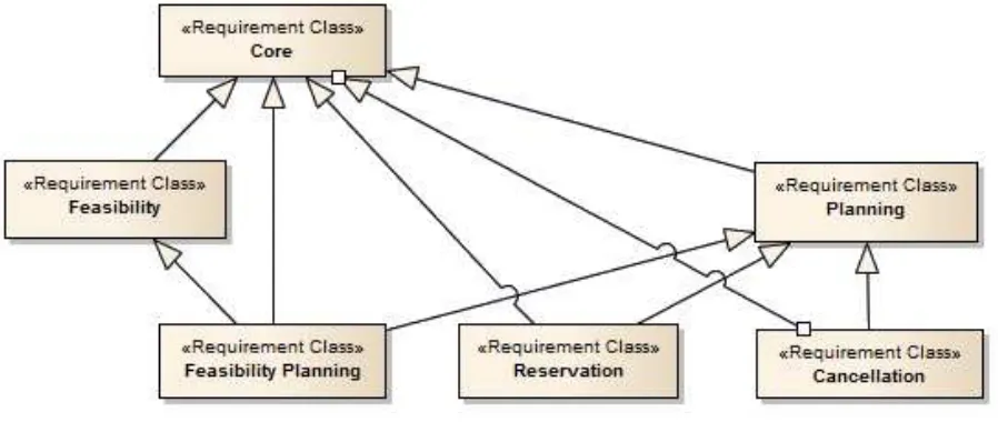
Core, which specifies the minimum behaviour that all RESET servers shall implement. It includes the support of the operations Tasking description, Sensor description or Task description.
Feasibility, which specifies the additional requirements a RESET server has to implement for performing a feasibility analysis process.
Planning, which specifies the additional requirements a RESET server shall implement for performing a planning process.
Feasibility Planning, which specifies the additional requirements a RESET server shall implement for performing a feasibility analysis process and then submitting the subsequent results.
Reservation, which specifies the additional requirements a RESET server shall implement for performing a feasibility analysis process and then submitting the subsequent results.
Cancellation, which specifies the additional requirements a RESET server shall implement for performing the cancellation of planning or reservation processes.
The inheritance relationship between the different classes represents the inheritance of all requirements from the super class. E.g.: The Feasibility class defines its specific requirements and includes the requirements defined in the Core class. Hence a Server claiming compliance to the Feasibility class has to comply with all the Feasibility and Core class requirements. The following table reports:
o The Requirement Class name,
o The URI,
o The dependency with other requirements classes.
Table 2-1 RESET Requirement Classes
Requirement Class
Requirement Class URI Dependency
Core http://www.opengis.net/spec/RESET/1.0/req/Core
Feasibility http://www.opengis.net/spec/RESET/1.0/req/Feasibility Core Planning http://www.opengis.net/spec/RESET/1.0/req/Planning Core Feasibility
Planning
http://www.opengis.net/spec/RESET/1.0/req/FeasibilityPlanning Core
Feasibility Planning Reservation http://www.opengis.net/spec/RESET/1.0/req/Reservation Core
Planning Cancellation http://www.opengis.net/spec/RESET/1.0/req/Cancellation Core
Planning
The root path of all Requirements and conformance test URIs defined in this document is: http://www.opengis.net/spec/RESET/1.0/
In order to conform to this OGC® interface standard, a software implementation shall choose to implement at least Core class and optionally the other classes.
A server that complies only with the Core class is a server supporting feasibility and planning based on identified EO sensors.
3.
References
The following normative documents contain provisions that, through reference in this text, constitute provisions of this document. For dated references, subsequent amendments to, or revisions of, any of these publications do not apply. For undated references, the latest edition of the normative document referred to applies.
3.1 Normative references
[NR1] IETF RFC4287, ATOM The Atom Syndication Format. 2005 [NR2] IETF RFC 3066, Tags for the Identification of Languages. 2001 [NR3] IETF RFC 3339, Date and Time on the Internet: Timestamps. 2002 [NR4] IETF RFC 5988, Web Linking. 2010
[NR5] OpenSearch, OpenSearch Specification, version 1.1 draft 5. [NR6] OpenSearch, OpenSearch Geo Extension, version 1.0 draft 2. [NR7] OpenSearch, OpenSearch Time Extension, version 1.0 draft 1. [NR8] OpenSearch, OpenSearch Parameters Extension, version 1.0 draft 2.
[NR9] OASIS, SearchRetrieve: Part 4. APD Binding for OpenSearch, version 1.0. 2013. [NR10] OGC 10-176r4, New OGC Document Template Draft.
[NR11] OGC 10-177r2, Guidance to Editors and Authors of OGC Documents that use the OGC Standards document template, version 1.2. 2012.
[NR12] OGC 06-135r11, Policy Directives for Writing and Publishing OGC Standards: TC Decisions. 2011.
[NR13] OGC 08-131r3, The Specification Model - A Standard for Modular specifications, version 1.0. 2009.
[NR20] OGC 08-094r1, SWE Common Data Model Encoding Standard, version 2.0.0. 2011.
[NR21] OGC 09-000, Sensor Planning Service Implementation Standard, version 2.0. 2011. [NR22] OGC 10-135, Sensor Planning Service Interface Standard 2.0 Earth Observation
Satellite Tasking Extension, version 2.0. 2011.
[NR23] OGC 10-039, OpenSearch Extension for Earth Observation Satellite Tasking, version 1.0. 2013.
[NR24] OGC 09-001, OGC SWE Service Model Implementation Standard, version 2.0. 2011.
[NR25] OGC 13-042, RESTful Encoding of Ordering Services Framework For Earth Observation Products, version 1.0. 2014.
3.2 Other references
[OR1] ESA, TM-21, Design Methodology, Architecture and Use of Geospatial
4.
Terms and Definitions
This document uses the terms defined in Sub-clause 5.3 of [OGC 06-121r8], which is based on the ISO/IEC Directives, Part 2, Rules for the structure and drafting of International Standards. In particular, the word “shall” (not “must”) is the verb form used to indicate a requirement to be strictly followed to conform to this standard.
For the purposes of this document, the following additional terms and definitions apply.
earth observation satellite
Artificial spacecraft specifically designed to observe the earth from orbit, often using sensors that are sensitive to some part of the electromagnetic spectrum.
identifier
A character string that may be composed of numbers and characters that is exchanged between the client and the server with respect to a specific identity of a resource.
OpenSearch
Draft specification for web search syndication, originating from Amazon's A9 project and given a corresponding interface binding by the OASIS Search Web Services working group.
profile
Set of one or more base standards and - where applicable - the identification of chosen clauses, classes, subsets, options and parameters of those base standards that are necessary for accomplishing a particular function [ISO 19101, ISO 19106].
procedure oriented architectural style
Platform-independent design approach that is focused on operations, their parameters and their results, that can be defined in an abstract level specification. Concrete platform dependent specifications can be derived from the abstract level, allowing, for example, KVP or SOAP messaging.
requirement
Task
Conceptual resource that represents an SPS assignment. It includes the (possibly empty) set of tasking parameters.
Tasking
Parameterizing an asset; can be done by sending one or more tasking requests.
Tasking request
Request with certain tasking semantics that contains tasking parameters.
Tasking Parameter
Parameter that has an influence on the parameterization of an asset.
URL component
Text contained after the context path between two forward slashes “/”, that are not placed between two matching parentheses “(...)”, and before any question mark character “?”.
URL component key
Text contained in a URL component that comes before an opening parenthesis “(“.
URL component value
Text contained in a URL component that is enclosed between the first opening parenthesis “(“ and the last closing parenthesis “)” in the → component.
Example In the http://example.org/component1/componentKey(componentValue), components are as follows:
Context Path: http://example.org/
URL Components: component1, componentKey(componentValue) URL Component Keys: component1, componentKey
5.
Conventions
This sections provides details and examples for any conventions used in the document. Examples of conventions are symbols, abbreviations, use of XML schema, or special notes regarding how to read the document.
5.1 Abbreviated terms
Some of the abbreviated terms listed in sub clause 5.1 of the OWS Common Implementation Specification (OGC 06-121) apply to this document, plus the following abbreviated terms. API Application Program Interface
ATM Atmospheric
COTS Commercial Off The Shelf
CQL Common Query Language
CRS Coordinate Reference System
DCE Distributed Computing Environment DCP Distributed Computing Platform DDS Data Dissemination Service
EC European Commission
EO Earth Observation
EO-SPS Earth Observation Satellite Tasking Extension for the SPS 2.0 Standard ESA European Space Agency
GCM GMES Collaborative Mission
GMES Global Monitoring for Environment and Security GML Geographic Markup Language
O&M Observations & Measurements OGC Open Geospatial Consortium OSDD OpenSearch Description Document
OASIS Organisation for the Advancement of Structured Information Standards
OPT Optical
RESET RESTful encoding of Sensor Planning Service for Earth Observation satellite Tasking
REST Representational State Transfer
ROSEO RESTful Encoding of Ordering Services Framework for Earth Observation Products
RSS Rich Site Summary SAR Synthetic Aperture Radar SensorML Sensor Model Language SPS Sensor Planning Service SWE Sensor Web Enablement SWS Search Web Services
UML Unified Modelling Language URI Uniform Resource Identifier URL Uniform Resource Locator URL Uniform Resource Name UUID Universal Unique Identifier URN Uniform Resource Name
UTF-8 Unicode Transformation Format-8 WSDL Web Service Definition Language W3C World Wide Web Consortium
5.2 UML notation
Most diagrams that appear in this standard are presented using the Unified Modeling Language (UML) static structure diagram, as described in sub-clause 5.2 of OGC 05-008. 5.3 Used parts of other documents
This document uses significant parts of document OGC 10-032. To reduce the need to refer to that document, this document copies some of those parts with small modifications. To indicate those parts to readers of this document, the largely copied parts are shown with a light grey background (15%).
5.4 Platform-neutral and platform-specific standards
As specified in Clause 10 of OGC Abstract Specification Topic 12 “OGC Service Architecture” (which contains ISO 19119), this document includes both Distributed Computing Platform-neutral and platform-specific standards. This document first specifies each operation request and response in platform-neutral fashion. This is done using a table for each data structure, which lists and defines the parameters and other data structures contained.
The specified platform-neutral data could be encoded in many alternative ways, each appropriate to one or more specific DCPs. This document now specifies encoding appropriate for use of HTTP GET transfer of operations requests (using KVP encoding), and for use of HTTP POST transfer of operations requests (using XML or KVP encoding).
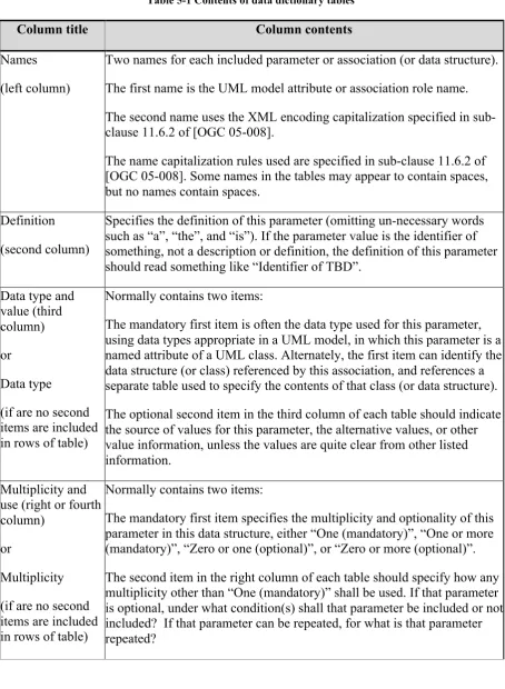
5.5 Data dictionary tables
When the data type used for this parameter, in the third column of such a table, is an enumeration or code list, all the values specified by a specific OWS shall be listed, together with the meaning of each value. When this information is extensive, these values and meanings should be specified in a separate table that is referenced in the third column of this table row.
Table 5-1 Contents of data dictionary tables
Column title Column contents
Names (left column)
Two names for each included parameter or association (or data structure). The first name is the UML model attribute or association role name. The second name uses the XML encoding capitalization specified in sub-clause 11.6.2 of [OGC 05-008].
The name capitalization rules used are specified in sub-clause 11.6.2 of [OGC 05-008]. Some names in the tables may appear to contain spaces, but no names contain spaces.
Definition (second column)
Specifies the definition of this parameter (omitting un-necessary words such as “a”, “the”, and “is”). If the parameter value is the identifier of something, not a description or definition, the definition of this parameter should read something like “Identifier of TBD”.
Data type and items are included in rows of table)
Normally contains two items:
The mandatory first item is often the data type used for this parameter, using data types appropriate in a UML model, in which this parameter is a named attribute of a UML class. Alternately, the first item can identify the data structure (or class) referenced by this association, and references a separate table used to specify the contents of that class (or data structure). The optional second item in the third column of each table should indicate the source of values for this parameter, the alternative values, or other value information, unless the values are quite clear from other listed information.
Multiplicity and use (right or fourth column)
or
Multiplicity (if are no second items are included in rows of table)
Normally contains two items:
6.
RESTful encoding of Sensor Planning Service for Earth Observation
satellite Tasking (RESET) overview
As highlighted in the introduction sections, this document provides a simplified and RESTful encoding of the parent specification Earth Observation Satellite Tasking Extension for SPS 2.0 [NR22].
This is a RESTful specification and so it is described in terms of resources. However it is derived from [NR22], which is a SOAP Web Service and thus is both operations centric and following an “RPC style” Both techniques have almost the same functionality. This then means that this specification can be identically described from the two different points of view. This section summarizes this specification from both a Resource point of view and from an RPC style point of view and explains how they relate to each other.
6.1 RPC view of RESET
RESET deals with the following information items:
‐ Sensor description, provides descriptions of the sensors that can be tasked. These descriptions can be provided in multiple OGC standards, including SensorML, SOS, etc.
‐ Tasking requests, are the requests to be sent. These contain all the information to configure the acquisition of a sensor, or set of sensors;
‐ Feasibility Study, describes the results of a feasibility request. This preliminary process allows the calculation of the possibilities offered by a given sensor to perform a given tasking request. This structure contains a list of Segments, which represent a given acquisition.
‐ Programming Status, describes the results of the submission of a task. It describes the current status of the Segment which represents a single acquisition.
From RPC perspective, this specification is composed of the following operations:
‐ GetCapabilities: allows a client to request and receive a service metadata (or Capabilities) document that describes the abilities of the specific server implementation.
‐ GetSensorAvailability / GetStationAvailability: these operations allow a user to check the availability of a sensor or a ground station.
‐ GetFeasibility: this operation requests the feasibility analysis process to be performed. The Segments provided by this function can then be submitted by the SubmitSegmentByID operation. Its results are also available through the GetTask operation.
‐ Submit, allows the submission of a planning task described by the Tasking Parameters to the mission planning system.
‐ SubmitSegmentByID, allows a user to submit a planning task created from the results of a Feasibility Analysis.
These operations are “asynchronous” meaning that they perform the submission of the task to the mission planning system and return a summary containing the status of the Segments that have been submitted.
To verify whether the submission has been successfully completed and to retrieve / manage the results, dedicated operations have to be called.
‐ GetStatus, allows the retrieval of the status of a planning task.
‐ GetTask, allows the retrieval of either the results of a Feasibility Study or of a submitted planning task.
‐ DescribeResultAccess, allows access to the submitted products ready for download once they have been acquired, downloaded to the Ground Station and processed as required.
‐ Cancel cancels a previously submitted planning task. This operation is a two-part process : the first call will evaluate the possibility of the cancellation and return a status report showing which segments can, or cannot, be cancelled, along with the time this report will be valid. The second call will then validate the cancellation of the segments that are cancellable.
‐ Validate allows the user to manually validate an acquisition once it has been acquired. Indeed, several attempts are sometimes needed for earth observation systems to acquire satisfactory data for an area of the earth surface. For instance, optical acquisitions are subject to cloud cover that can prevent clear imaging of the region of interest. In this case new acquisitions are performed until the region of interest is imaged properly. This operation provides a means to confirm that the last acquisition fits the user’s needs.
‐ A set of additional information that allows the implementation of a reservation system. It includes the following operations :
o Reserve that allows the user to reserve a task before submitting it, for example if the user wants to perform another feasibility study before confirming.
o Update allows the changing of the parameters of a reserved task.
6.2 Resource view of RESET
From the “Resource” perspective, this specification is composed of the following resources:
‐ Service Metadata: Describes the service capabilities, supported operations, supported collections and other service capabilities.
The following HTTP methods are used:
o GET: returns the capabilities of the system.
‐ Procedures: Describes the sensors offered by the server. The following HTTP methods are used:
o GET /procedures/{sps:procedure}/{swes: procedureDescriptionFormat?}: equivalent to the DescribeSensor operation. Allows the retrieval of the capabilities of a sensor in the given format (providing it is used by the server).
o GET /procedures/{sps:procedure}/tasking: equivalent to DescribeTasking.
o GET /procedures/{sps:procedure}/availability: equivalent to GetSensorAvailibility.
‐ Ground Stations: Retrieves information about a ground station.
o GET /groundstation/{eosps:station}: Describes the ground station.
o GET /groundstation/{eosps:station}/availability: equivalent to GetStationAvailability.
‐ Feasibility: Perform a Feasibility Analysis on a given sensor or type of sensor (optical, SAR, etc.), as well as accessing its results. The following HTTP methods are used :
o POST /feasibility: equivalent to GetFeasibility. The content of the request shall be based on the response provided by the DescribeTasking operation.
o POST /feasibility/{sps:taskID}:equivalent to SubmitSegmentByID in the RPC view of RESET 6.1 above. The method submits a set of segments that have been produced by a Feasibility Analysis.
o GET /feasibility/{ sps:taskID}: equivalent to GetTask. The method retrieves the results of a Feasibility Analysis.
‐ Reservation: allows the user to reserve a task before submitting it. The following HTTP methods are used :
o POST /reservation: equivalent to the Reserve operation. Allows the user to reserve a planning task for a certain time.
request shall be based on the response provided by the DescribeTasking operation.
o GET /planning/{ sps:taskID}: equivalent to the GetStatus operation. Checks the status of a task.
o GET /planning/{ sps:taskID}/segments: equivalent to the GetTask operation. Retrieves a complete report of the task, with description of all segments submitted and their status. It should also be used prior to a Cancel request in order to assess the possibility of the cancellation.
o POST /planning/{ sps:taskID}/segments/{ eosps:segmentID}: equivalent to the Validate operation. Allows the user to validate an acquisition as corresponding to the user’s needs.
o GET /planning/{ sps:taskID}/results: equivalent to DescribeResultAccess.
o DELETE /planning/{ sps:taskID}: equivalent to the Cancel operation. Cancels a selected task.
6.3 Essential use cases
The scenarios described here demonstrate the three basic use cases that perform the submission of a planning task to a (set of) mission planning system(s).
In these scenarios, the following entities are specified:
‐ RESET client: the client application or user that will send the requests to the client.
‐ RESET server: the server application that will handle those requests.
6.3.1 Planning with feasibility study The typical scenario is:
‐ The client gets the capabilities of the server using the GetCapabilities operation (GET /).
‐ Selects the sensor to be tasked from the GetCapabilities and optionally (if more information is required) the DescribeSensor methods
(GET /procedures/{sps:procedure}/{swes:sensorDescriptionFormat?}). The user then requests the format of the Tasking parameters needed to submit a task, through the DescribeTasking operation
(GET /procedures/{sps:procedure}/tasking).
‐ Then this structure is filled in on the client side, allowing the user to choose the area of interest, the time of interest, as well as other parameters such as the instrument mode.
‐ This structure is then sent to the server as part of a GetFeasibility request (corresponding to POST /feasibility). This will return a set of segments representing acquisitions that fulfill the given tasking parameters.
‐ The user will then assess these results in order to choose the segments required to be submitted for acquisition. These segments will then be submitted using the SubmitSegmentByID (POST /feasibility/{taskID}). This will start a new planning task.
‐ After that, the following events are possible:
o The user requests the status of the task using the GetStatus operation (GET /planning/{taskID}), or the complete description of the task using the GetTask operation (GET /planning/{taskID}/segments).
o The user cancels the task using the Cancel operation (DELETE /planning/{taskID}).
‐ Once the task is finished, which corresponds to all segments involved begin acquired, the user can do the following:
o Get the data describing a given segment, through the GetTask (GET /planning/{taskID}/segments), and the results with the DescribeResultAccess operation (GET /planning/{taskID}/results). This will provide the means to connect to the Download Server in order to get the acquired products.
Figure 6-1 Planning with Feasibility study sequence diagram sd FeasibilityPlanning
RESET Client RESET Server Download Server
opt
opt
opt
opt
GetCapabilities()
DescribeSensor()
DescribeTasking()
FillInRequest()
GetFeasibility(taskingParameters)
SubmitSegmentByID(taskID, segments)
getStatus(taskID)
cancel(taskID)
getTask(taskID)
describeResultAccess(taskID)
validate(taskID, segmentID)
6.3.2 Direct planning The typical scenario is:
‐ The client gets the capabilities of the server using the GetCapabilities operation (GET /).
‐ Selects the sensor to be tasked from the GetCapabilities and optionally (if more information is required) the DescribeSensor methods
(GET /procedures/{sps:procedure}/{swes:sensorDescriptionFormat?}). The user then requests the format of the Tasking parameters needed to submit a task, through the DescribeTasking operation
(GET /procedures/{sps:procedure}/tasking).
‐ Then this structure is filled in on the client side, allowing the user to choose the area of interest, the time of interest, as well as other parameters such as the instrument mode.
‐ This structure is then sent to the server as part of a Submit request (corresponding to POST /planning). This will return a set of segments representing the acquisitions that have been submitted to fulfill the given request. This will start a new planning task.
‐ After that, the following events are possible:
o The user requests the status of the task using the GetStatus operation (GET /planning/{taskID}), or the complete description of the task using the GetTask operation (GET /planning/{taskID}/segments).
o The user cancels the task using the Cancel operation (DELETE /planning/{taskID}).
‐ Once the task is finished, which corresponds to all segments involved begin acquired, the user can do the following:
o Get the data describing a given segment, through the GetTask (GET /planning/{taskID}/segments), and the results with the DescribeResultAccess operation (GET /planning/{taskID}/results). This will provide the means to connect to the Download Server in order to get the acquired products.
Figure 6-2 Direct planning sequence diagram
sd DirectPlanning
RESET Client RESET Server Download Server
opt
opt
opt
opt
getCapabilities()
describeSensor()
describeTasking()
fillInRequest()
submit(taskingParameters)
getStatus(taskID)
cancel(taskID)
getTask(taskID)
describeResultAccess(taskID)
validate(taskID, segmentID)
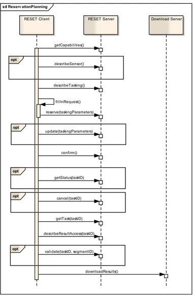
6.3.3 Reservation planning The typical scenario is:
‐ The client gets the capabilities of the server using the GetCapabilities operation (GET /).
‐ Selects the sensor to be tasked from the GetCapabilities and optionally (if more information is required) the DescribeSensor methods
(GET /procedures/{sps:procedure}/{swes:sensorDescriptionFormat?}). The user then requests the format of the Tasking parameters needed to submit a task, through the DescribeTasking operation
(GET /procedures/{sps:procedure}/tasking).
‐ Then this structure is filled in on the client side, allowing the user to choose the area of interest, the time of interest, as well as other parameters such as the instrument mode.
‐ This structure is then sent to the server as part of a Reserve request (corresponding to POST /reservation). This will return a set of segments representing the acquisitions that have been submitted to fulfill the given request. This will start a new reservation task.
‐ This will reserve the task. The user then has the possibility, until the reservation expiration time, to change the request by using the Update operation (PUT /reservation/{taskID}).
‐ If the result is satisfactory, the user can then submit the task with the Confirm operation (POST /reservation/{taskID}). This will start a new planning task.
‐ After that, the following events are possible:
o The user requests the status of the task using the GetStatus operation (GET /planning/{taskID}), or the complete description of the task using the GetTask operation (GET /planning/{taskID}/segments).
o The user cancels the task using the Cancel operation (DELETE /planning/{taskID}).
‐ Once the task is finished, which corresponds to all segments involved begin acquired, the user can do the following:
o Get the data describing a given segment, through the GetTask (GET /planning/{taskID}/segments), and the results with the DescribeResultAccess operation(GET /planning/{taskID}/results). This will provide the means to connect to the Download Server in order to get the acquired products.
Figure 6-3 Reservation planning sequence diagram
e er ationPlanning
RESET Client RESET Server Download Server
opt
opt
opt
opt
opt
getCapabilities()
describeSensor()
describeTasking()
fillInRequest()
reserve(taskingParameters)
update(taskingParameters)
confirm()
getStatus(taskID)
cancel(taskID)
getTask(taskID)
describeResultAccess(taskID)
validate(taskID, segmentID)
7.
Resource model
This section reports all resources defined in this specification including: The URL addressing the resource;
The detailed definition, via XML schema notations;
Supported HTTP methods (e.g. GET, POST) and provided operations. A sub-section is dedicated to each of them.
7.1 Resource root path
All RESET resources belong to the same root path defined as follow:
‐ <serviceRootURL>: http://<hostName>:<hostPort>/<contextPath> ‐ <ResetRootPath>: <serviceRootURL>/RESET/<version>
Where:
‐ <hostName>: the IP address of the server, or the associated DNS address.
‐ <hostPort>: the port at which the application server containing the server listens.
‐ <contextPath>: the path of the web application implementing the RESET interface, within the application server context.
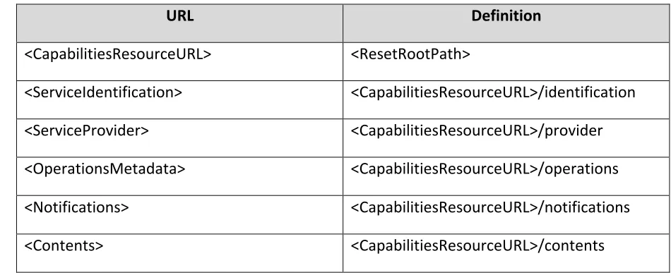
7.2 Capabilities resource
Capabilities resource contains metadata about the RESET server’s capabilities, e.g. identifier, description, restrictions, supported operations, contents, etc.
These capabilities are based on the SPS Capabilities structure, which is itself based on the OWS Capabilities structure, applying the HTTP profile. This profile describes URIs to access with given HTTP methods to a RESTful web service.
Therefore, it contains links to all the other resources accessible on the server, by describing the URLs that provide access to these resources.
7.2.1 URL
Table 7-1 Capabilities URL
URL Definition
<CapabilitiesResourceURL> <ResetRootPath>
<ServiceIdentification> <CapabilitiesResourceURL>/identification
<ServiceProvider> <CapabilitiesResourceURL>/provider
<OperationsMetadata> <CapabilitiesResourceURL>/operations
<Notifications> <CapabilitiesResourceURL>/notifications
7.2.2 Definition
The capabilities document is described in the SPS Specification [NR21]. Therefore, the only part described here will be the OperationMetadata, which will create the URIs to access the other resources.
This structure used is the following:
<ows:OperationsMetadata xmlns:ows="http://www.opengis.net/ows/1.1">
<ows:Operation>
<ows:DCP>
<ows:HTTP>
<ows:Get
xmlns:xlin="http://www.w3.org/1999/xlink"
xlin:href=" <ResetRootPath>/procedures/{procedure}/tasking">
<ows:Constraint name="procedure">
<ows:AllowedValues>
<ows:Value>OPT</ows:Value>
</ows:AllowedValues>
<ows:AllowedValues>
<ows:Value>SAR</ows:Value>
</ows:AllowedValues>
</ows:Constraint>
</ows:Get>
</ows:HTTP>
</ows:DCP>
</ows:Operation>
<ows:OperationsMetadata>
Figure 7-1 Operation Metadata example
However the OWS specification did not foresee the use of the PUT and DELETE HTTP methods. Neither did it provide a way to add these to the OperationsMetadata structure without redefining the whole structure. Therefore the OperationsMetadata structure was replaced in the ROSEO specification [NR24]by the following:
<ns:resourceURL resource="feasibility" methods="POST"
URL="http://127.0.0.1:8080/DreamServices/dream/mmfas/gmes-mmfas/
reset/1.0.0/feasibility/"/>
<ns:resourceURL resource="feasibility" methods="GET"
URL="http://127.0.0.1:8080/DreamServices/dream/mmfas/gmes-mmfas/
reset/1.0.0/feasibility/{taskID}"/>
<ns:resourceURL resource="feasibility" methods="GET"
URL="http://127.0.0.1:8080/DreamServices/dream/mmfas/gmes-mmfas/
7.2.3 HTTP methods
Table 7-2 Capabilities HTTP methods
HTTP Method
URL Definition Request Entity Body
Response Entity Body
GET <RESET Root Path> It returns the complete capabilities document.
Empty <sps:Capabilities> element instance <RESET Root
Path>/ServiceIdentificat ion
It returns the
ServiceIdentification
It returns the ServiceProvider
It returns the Contents element.
Empty <sps:Contents> element instance <RESET Root
Path>/OperationsMetad ata
It returns the
OperationsMetadata element.
Empty <ows:
OperationsMetadata > element instance <RESET Root
Path>/Notifications
It returns the
Notifications element.
Empty <sps: Notifications > element instance POST Not used by this
The following table reports the possible error conditions with the defined HTTP responses. Table 7-3 Capabilities Error Handling
Error Description HTTP Error
Code
OGC Exception Report
“exceptionCode” “locator” “ExceptionText”
Bad Input Parameter.
E.g. an incorrect Capabilities sub-section has been specified.
400 InvalidParameterValu e
Name of parameter with invalid value.
“Invalid value for Parameter”
Internal Server Error
An error occurred inside the server while processing the request.
7.3 Procedures resource
The procedures resource contains descriptions of the sensors handled on this server, as well as the description of the associated tasking requests. It shall contain all the sensors described in the Contents section of the Capabilities resource see 7.2 above.
These description resources are split into three parts:
‐ Sensor description: an XML description of the sensor, including its modes, covered area, and sensor-specific parameters, in a given format, e.g. SensorML, etc.
‐ Tasking requests description: the parameters structure to be sent to task a specific sensor.
‐ Availability: an optional resource that provides the periods of availability of a sensor.
7.3.1 URL
Table 7-4 Procedures URL
URL Definition
<ProcedureResourceURL> <ResetRootPath>/procedures/{procedure}/
<Sensor Description>
in canonical XML format <ProcedureResourceURL>/{sensorDescriptionFormat}
<Sensor and Tasking Description> in OpenSearch Description Document (OSDD)
<ProcedureResourceURL>/osdd
<Tasking Description> <ProcedureResourceURL>/tasking
<Availability> <ProcedureResourceURL>/availability
Table 7-5 Procedures URL parameters
Names Definition Data type and values
{procedure} Identifier of the sensor, or sensor type, which description is required.
‐ Description of the sensor’s capabilities in various formats.
‐ Description of the format of the tasking request needed to task the sensor.
‐ Optionally, the availability of the sensor.
‐ Optionally, the OpenSearch Description Document based on the OS EOSP specification [NR23]. This specification allows the submission of feasibility requests using the OpenSearch specification. This alternative format has been proposed in order to support online data access scenario’s in which the result of the catalogue access includes not only the metadata records matching the query, but also pre-built URLs for direct ordering & downloading of the search results.
7.3.2.1 Sensor capabilities
The DescribeSensor operation is used to obtain a detailed sensor/procedure description encoded in a certain format, for example SensorML. As an SWE service might offer such descriptions in multiple formats, or different versions of the same format, clients generally need to indicate which format they require. The formats supported by a given sensor/procedure are defined in the Capabilities of the service.
Further description of the DescribeSensor operation is available in the SWES specification [NR23].
7.3.2.2 Tasking request description
The DescribeTasking operation is used to get the XML structure that is needed to submit feasibility or planning requests. This structure contains the basic parameters such as the Area of Interest, Time of Interest, as well as instrument modes and sensor specific acquisition and validation parameters. The full description of these parameters is available in the EO-SPS specification [NR22].
7.3.2.3 Sensor availabilities
7.3.3 HTTP methods
Table 7-6 Procedures HTTP methods
HTTP Method
URL Definition Request Entity
Body
Response Entity Body
GET <ResetRootPath>/proce dures/{procedure}/{sens orDescriptionFormat}
It returns the description of the sensor in the required format.
It returns the
ServiceIdentification element.
Empty <swes:ServiceIdentification> element instance
<ResetRootPath>/proce dures/{procedure}/taski ng
It returns the ServiceProvider element.
Empty <swes:
procedureDescriptionFormat > element instance
<ResetRootPath>/proce dures/{procedure}/avail ability
It returns the Contents element.
Table 7-7 Procedures HTTP methods parameters
Names Definition Data type and value
{procedure} Identifier of the sensor, or sensor type, which description
7.3.4 Error handling
In the event that a RESET server encounters an error during the accessing of the procedure description resources, it returns an HTTP response including:
HTTP Status Code: 4XX for errors on the client side; 5XX for errors on server side. HTTP Entity Body: ows:ExceptionReport element set as specified in §8 of [NR15]. The following table reports the possible error conditions with the defined HTTP responses.
Table 7-8 Procedures Error handling
Error Description HTTP Error
Code
OGC Exception Report
“exceptionCode” “locator” “ExceptionText”
Missing Parameter.
E.g. no sensor or sensor type has been specified.
400 MissingParameterVal ue
Name of missing parameter.
“Missing value for Parameter”
Bad Input Parameter. E.g. an incorrect sensor or sensor type has been specified.
“Invalid value for Parameter”
Internal Server Error
An error occurred inside the server while processing the request.
500 “NoApplicableCode”
Authentication Fail 401 AuthenticationFailed “identity_token” “Invalid or missing identity
information” Authorization Fail 403 AuthorizationFailed “procedure” Text describing the
7.4 Feasibility resource
The Feasibility resource is the envelope sent from the client to calculate the feasibility of a tasking request with the selected tasking parameters. Additionally, this resource provides a means to get the status of the request and the results it produces. These results consist of segments that can then be submitted by the user as future acquisitions.
This resource contains the following elements:
‐ FeasibilityResourceURL(base URL): the base URI of the feasibility resource. It is also the URL where the feasibility analysis request shall be sent.
‐ FeasibilityTaskResourceURL: provides access to the result of a given task. It is also the URL where the user shall send the requests in order to submit some segments that are part of this task’s results.
7.4.1 URL
Table 7-9 Feasibility URL
URL Definition
<FeasibilityResourceURL> / <AllTasks> <ResetRootPath>/feasibility/
<Task Status By ID>
in canonical XML format <FeasibilityResourceURL>/{taskId}
<TaskSegmentsByID>
in canonical XML format <FeasibilityResourceURL>/{taskId}/segments
Table 7-10 Feasibility URL parameters
Names Definition Data type and values
{taskId} Identifier of the task required by the user.
7.4.2 Definition
The Feasibility resource implements the following operations of the EO-SPS specification:
‐ GetFeasibility (POST /{ FeasibilityResourceURL}):
This operation starts a feasibility analysis, which is a preliminary calculation of the capabilities of a given sensor, or set of sensors, to acquire a given Area of Interest during a certain Time of Interest. This calculation can be done synchronously or asynchronously. In the case of an asynchronous process, the results of the process shall be available through a GetTask operation;
‐ Get Status (GET /{ FeasibilityResourceURL}/{taskId}/):
This operation should only be implemented in the case of an asynchronous implementation. In which case, the response will provide the status of the task.
‐ GetTask (GET /{ FeasibilityResourceURL}/{taskId}/segments/): This operation retrieves the results of a feasibility analysis process.
‐ SubmitSegmentByID (POST /{ FeasibilityResourceURL}/{taskId}/segments/):
This operation allows the user to submit some individual segments from the task results for a planning request.
7.4.2.1 Submitting a feasibility request
The GetFeasibility request is a POST request that contains the following elements:
‐ Synchronous: a Boolean that allows the selection of synchronous and asynchronous modes for the calculation of the feasibility analysis.
‐ Procedure: the sensor or sensor type that will be used to complete the request.
‐ Tasking parameters: the XML structure containing the parameters of the request. This includes Area of Interest, Time of Interest as well as Acquisition and Validation parameters. This structure is provided by the DescribeTasking request and is described in the EO-SPS specification [NR22].
The response to this request depends on the mode chosen in the request:
‐ In the asynchronous mode, the response will only contain a status report stating if the request has been accepted by the server or not. The response is in XML format and is based on the StatusReport defined in the SPS specification [NR22]. The status of the task will be GETFEASIBILITY_PENDING.
7.4.2.2 Checking the status of a task
The GetStatus operation is optional and should only be implemented if the server implements asynchronous processing. In this case, it allows a user to check the status of a task. The response is based on the StatusReport of the SPS specification [NR22].
7.4.2.3 Getting the segments of a task
The GetTask operation provides access to the results of a feasibility task that has been completed. The response to this request is based on the same structures as the response to a GetFeasibility request:
‐ StatusReport: a summary of the status of the task. It contains the ID of the task, the sensor used, the status of the task and the parameters provided in the tasking request.
‐ FeasibilityStudy: the result of a feasibility analysis. It is composed of a list of segments. The Segment structure contains the full description of an acquisition, including the footprint describing the area covered, the time of acquisition, the sensor used and its mode. It can also be extended to contain additional information, e.g. Downlink information, cloud coverage, etc.
7.4.2.4 Submitting segments for planning
The SebmitSegmentByID operation allows the user to use the results of a feasibility analysis in order to submit the segments for planning. This request requires the following information:
‐ taskId: the ID of the task containing the segments that the user wants to submit.
‐ segmentId (multiple): a list of segment identifiers. This identifier is part of the Segment structure as defined in the EO-SPS specification [NR22].
This operation will create a planning task that will be available in the Planning resource 7.5 below.
The response to the operation will include the following elements:
‐ StatusReport: a summary of the status of the task. It contains the ID of the task, the sensor used, the status of the task and the parameters provided in the tasking request.
7.4.3 HTTP methods
Table 7-11 Feasibility HTTP methods
HTTP Method
URL Definition Request Entity Body
Response Entity Body
GET <ResetRootPath> /feasibility/{taskId}
Equivalent to GetStatus
It returns the status of a task.
Empty < eosps:StatusReport > element instance
<ResetRootPath> /feasibility/{taskId}/seg ments
Equivalent to GetTask. It returns the results of a task.
Empty < eosps:StatusReport > element instance <
eosps:FeasibilityStudy> element instance
POST <ResetRootPath> /feasibility?synchronous ={isSynchronous}
Equivalent to GetFeasibility Permits to perform a Feasibility analysis.
EO-SPS: Tasking Parameters
< eosps:StatusReport > element instance <
eosps:FeasibilityStudy> element instance if synchronous processing It permits to submit the segments resulting from a Feasibility Analysis.
Empty < eosps:StatusReport > element instance <eosps:FeasibilityStudy > element instance
PUT Not used by this document. DELETE Not used by this
document.
Table 7-12 Feasibility HTTP methods parameters
Names Definition Data type and value
{taskId} Identifier of the sensor, or sensor type, which description is required.
xs:string (max 255 chars) URL encoded
Allowed values are described in the GetTask operation.
{segmentId} Identifier of a segment, within the given task, to be submitted for planning.
xs:string (max 255 chars) URL encoded
Allowed values are described in the GetTask operation
{ isSynchronous } A Boolean permitting the client to choose between synchronous and asynchronous processing when starting a feasibility analysis.
7.4.4 Error handling
In the event that a RESET server encounters an error during the accessing of the procedure description resources, it returns an HTTP response including:
HTTP Status Code: 4XX for errors on the client side; 5XX for errors on server side. HTTP Entity Body: ows:ExceptionReport element set as specified in §8 of [NR15]. The following table reports the possible error conditions with the defined HTTP responses.
Table 7-13 Feasibility Error handling
Error Description HTTP Error
Code
OGC Exception Report
“exceptionCode” “locator” “ExceptionText”
Missing Parameter.
E.g. no sensor or sensor type has been specified.
400 MissingParameterVal ue
Name of missing parameter.
“Missing value for Parameter”
Bad Input Parameter. E.g. an incorrect sensor or sensor type has been specified.
“Invalid value for Parameter”
Internal Server Error
An error occurred inside the server while processing the request.
500 “NoApplicableCode”
Authentication Fail 401 AuthenticationFailed “identity_token” “Invalid or missing identity information” Authorization Fail 403 AuthorizationFailed “taskId” Text describing
7.5 Planning resource
The Planning resource is the envelope sent from the client to submit a planning request to the associated mission planning system. This request can be submitted in three different ways: first by reserving and confirming it, second by directly sending the tasking parameters and finally by computing a feasibility analysis and submit some of the resulting segments. Additionally, this resource gets the status of the request and the results it produces. These results consist of segments that have been submitted for acquisition. It also allows the user to submit those segments for the actual acquisition.
This resource contains the following elements:
‐ PlanningResourceURL (base URL): the base URI of the planning resource. It is also the URL where the planning requests shall be sent.
‐ PlanningTaskResourceURL: provides access to the result of a given task. It also allows cancellation of that task.
‐ PlanningTaskSegmentsResourceURL: provides access to the segments that this task contains. It also provides a means to validate those segments once the results are available.
7.5.1 URL
Table 7-14 Planning URL
Definition URL
<PlanningResourceURL> / <AllTasks> <ResetRootPath>/planning/
<Task Status By ID>
in canonical XML format < PlanningResourceURL >/{taskId}
<TaskSegmentsBy ID>
in canonical XML format < PlanningResourceURL >/{taskId}/segments
<TaskResultsBy ID>
in canonical XML format < PlanningResourceURL >/{taskId}/results
<SegmentBy ID>