Open Geospatial Consortium
Date: 2011-03-28
Reference number of this OGC® project document: OGC 10-135
OGC name of this OGC® project document: http://www.opengis.net/doc/IS/EOSPS/2.0
Version:2.0
Category: OGC® Interface Standard
Editors: Alexandre Robin (Spot Image) Philippe Mérigot (Spot Image)
OGC
®Sensor Planning Service Interface Standard 2.0
Earth Observation Satellite Tasking Extension
Copyright notice
Copyright © 2011 Open Geospatial Consortium
To obtain additional rights of use, visit http://www.opengeospatial.org/legal/.
Warning
License Agreement
Permission is hereby granted by the Open Geospatial Consortium, ("Licensor"), free of charge and subject to the terms set forth below, to any person obtaining a copy of this Intellectual Property and any associated documentation, to deal in the Intellectual Property without restriction (except as set forth below), including without limitation the rights to implement, use, copy, modify, merge, publish, distribute, and/or sublicense copies of the Intellectual Property, and to permit persons to whom the Intellectual Property is furnished to do so, provided that all copyright notices on the intellectual property are retained intact and that each person to whom the Intellectual Property is furnished agrees to the terms of this Agreement.
If you modify the Intellectual Property, all copies of the modified Intellectual Property must include, in addition to the above copyright notice, a notice that the Intellectual Property includes modifications that have not been approved or adopted by LICENSOR. THIS LICENSE IS A COPYRIGHT LICENSE ONLY, AND DOES NOT CONVEY ANY RIGHTS UNDER ANY PATENTS THAT MAY BE IN FORCE ANYWHERE IN THE WORLD.
THE INTELLECTUAL PROPERTY IS PROVIDED "AS IS", WITHOUT WARRANTY OF ANY KIND, EXPRESS OR IMPLIED, INCLUDING BUT NOT LIMITED TO THE WARRANTIES OF MERCHANTABILITY, FITNESS FOR A PARTICULAR PURPOSE, AND NONINFRINGEMENT OF THIRD PARTY RIGHTS. THE COPYRIGHT HOLDER OR HOLDERS INCLUDED IN THIS NOTICE DO NOT WARRANT THAT THE FUNCTIONS CONTAINED IN THE INTELLECTUAL PROPERTY WILL MEET YOUR REQUIREMENTS OR THAT THE OPERATION OF THE INTELLECTUAL PROPERTY WILL BE UNINTERRUPTED OR ERROR FREE. ANY USE OF THE INTELLECTUAL PROPERTY SHALL BE MADE ENTIRELY AT THE USER’S OWN RISK. IN NO EVENT SHALL THE COPYRIGHT HOLDER OR ANY CONTRIBUTOR OF INTELLECTUAL PROPERTY RIGHTS TO THE INTELLECTUAL PROPERTY BE LIABLE FOR ANY CLAIM, OR ANY DIRECT, SPECIAL, INDIRECT OR CONSEQUENTIAL DAMAGES, OR ANY DAMAGES WHATSOEVER RESULTING FROM ANY ALLEGED INFRINGEMENT OR ANY LOSS OF USE, DATA OR PROFITS, WHETHER IN AN ACTION OF CONTRACT, NEGLIGENCE OR UNDER ANY OTHER LEGAL THEORY, ARISING OUT OF OR IN CONNECTION WITH THE IMPLEMENTATION, USE, COMMERCIALIZATION OR PERFORMANCE OF THIS INTELLECTUAL PROPERTY. This license is effective until terminated. You may terminate it at any time by destroying the Intellectual Property together with all copies in any form. The license will also terminate if you fail to comply with any term or condition of this Agreement. Except as provided in the following sentence, no such termination of this license shall require the termination of any third party end-user sublicense to the Intellectual Property which is in force as of the date of notice of such termination. In addition, should the Intellectual Property, or the operation of the Intellectual Property, infringe, or in LICENSOR’s sole opinion be likely to infringe, any patent, copyright, trademark or other right of a third party, you agree that LICENSOR, in its sole discretion, may terminate this license without any compensation or liability to you, your licensees or any other party. You agree upon termination of any kind to destroy or cause to be destroyed the Intellectual Property together with all copies in any form, whether held by you or by any third party. Except as contained in this notice, the name of LICENSOR or of any other holder of a copyright in all or part of the Intellectual Property shall not be used in advertising or otherwise to promote the sale, use or other dealings in this Intellectual Property without prior written authorization of LICENSOR or such copyright holder. LICENSOR is and shall at all times be the sole entity that may authorize you or any third party to use certification marks, trademarks or other special designations to indicate compliance with any LICENSOR standards or specifications.
This Agreement is governed by the laws of the Commonwealth of Massachusetts. The application to this Agreement of the United Nations Convention on Contracts for the International Sale of Goods is hereby expressly excluded. In the event any provision of this Agreement shall be deemed unenforceable, void or invalid, such provision shall be modified so as to make it valid and enforceable, and as so modified the entire Agreement shall remain in full force and effect. No decision, action or inaction by LICENSOR shall be construed to be a waiver of any rights or remedies available to it.
Contents
Page1 SCOPE ... 11
2 COMPLIANCE ... 12
3 NORMATIVE REFERENCES ... 13
4 TERMS AND DEFINITIONS ... 14
5 CONVENTIONS ... 15
5.1 Abbreviated terms ... 15
5.2 UML notation ... 16
5.3 Used parts of other documents ... 16
5.4 Platform-neutral and platform-specific standards ... 16
5.5 Table notation used to express requirements ... 17
6 EO SPS OVERVIEW ... 18
7 EXTENSIONS TO EXISTING SPS OPERATIONS ... 20
7.1 Requirements Class: Core requirements for all mission types ... 20
7.1.1 Introduction ... 20
7.1.2 Tasking parameters ... 20
7.1.3 Auxiliary parameters ... 47
7.1.4 Feasibility study model ... 51
7.1.5 Programming status model ... 55
7.1.6 GridCell and Segment model ... 59
7.1.7 Expected behavior of the GetStatus operation ... 65
7.2 Requirements Class: Additional extensions for optical missions ... 66
7.2.1 Introduction ... 66
7.2.2 Additional tasking parameters specific to optical missions ... 66
7.2.3 Tasking responses for optical missions ... 71
7.3 Requirements Class: Additional extensions for SAR missions ... 72
7.3.1 Introduction ... 72
7.3.2 Additional tasking parameters specific to radar (SAR) missions ... 72
7.3.3 Tasking responses for SAR missions ... 76
8 ADDITIONAL OPERATIONS AND SOAP BINDING ... 77
8.1 Requirements Class: GetSensorAvailability Operation ... 77
8.1.1 Introduction ... 77
8.1.3 XML Encoding ... 79
8.1.4 Exceptions ... 81
8.2 Requirements Class: Validate Operation ... 83
8.2.1 Introduction ... 83
8.2.2 Data model ... 83
8.2.3 XML Encoding ... 85
8.2.4 Exceptions ... 86
8.2.5 ManualValidation request extension element ... 87
8.3 Requirements Class: SubmitSegmentByID Operation ... 89
8.3.1 Introduction ... 89
8.3.2 Data model ... 89
8.3.3 XML Encoding ... 91
8.3.4 Exceptions ... 91
8.4 Requirements Class: SOAP binding ... 93
8.4.1 Introduction ... 93
8.4.2 Action URIs ... 93
8.4.3 Asynchronous call to GetFeasibility with WS-Addressing ... 94
9 EXTENSIONS TO THE SPS NOTIFICATION SYSTEM ... 95
9.1 Introduction ... 95
Figures
Figure 1 – UML diagram of the ProgrammingRequest class ... 23
Figure 2 – UML diagram of the QualityOfService class ... 24
Figure 3 – UML diagram of the CoverageProgrammingRequest class ... 26
Figure 4 – UML diagram of the SwathProgrammingRequest class ... 27
Figure 5 – UML diagram of the RegionOfInterest class ... 31
Figure 6 – UML diagram of the TimeOfInterest class ... 34
Figure 7 – UML diagram of the TimeSeries class ... 36
Figure 8 – UML diagram of the AcquisitionType class ... 38
Figure 9 – UML diagram of the MonoscopicAcquisition class ... 39
Figure 10 – UML diagram of the StereoscopicAcquisition class ... 41
Figure 11 – UML diagram of the AcquisitionAngleRange class and its sub-classes ... 43
Figure 12 – UML diagram of the AcquisitionParameters class ... 46
Figure 13 – UML diagram of the ValidationParameters class ... 47
Figure 14 – UML diagram of the FeasibilityStudy class ... 53
Figure 15 – UML diagram of the ProgrammingStatus class ... 57
Figure 16 – UML diagram of the GridCell class ... 59
Figure 17 – UML diagram of the Segment class ... 62
Figure 18 – UML diagram of the AcquisitionParametersOPT class ... 67
Figure 19 – UML diagram of the ValidationParametersOPT class ... 70
Figure 20 – UML diagram of the AcquisitionParametersSAR class ... 73
Figure 21 – UML diagram of the ValidationParametersSAR class ... 75
Figure 22 – UML diagram of the GetSensorAvailability operation ... 78
Figure 23 – UML diagram of the Validate operation ... 84
i.
Abstract
The SPS 2.0 Earth Observation Satellite Tasking Extension Standard specifies extensions to the OGC Sensor Planning Service (SPS) 2.0 Interface Standard. The SPS configuration proposed in this extension is intended to support the programming process of Earth Observation (EO) sensor systems. This standard describes a consistent SPS configuration that can be supported by many satellite data providers, most of whom have existing facilities for the management of these programming requests. The resulting extended web service interface can be used for determining the feasibility of an intended sensor planning request, for submitting such a request, for inquiring about the status of such a request, for updating or canceling such a request, and for requesting information on means of obtaining the data collected by the requested task.
ii.
Keywords
ogcdoc, sps, earth observation, hma, eo
iii.
Preface
This document defines an extension of the version 2.0 of the Sensor Planning Service (SPS) Interface Standard. It is applicable to the tasking of earth observation satellites. This standard has been developed in the context of the Heterogeneous Mission Accessibility (HMA) project initiated by European Space Agency (ESA). The goal of this extension is to define a coherent web service interface for sending requests for future acquisition of data products to various types of space borne earth observation systems. Suggested additions, changes, and comments on this draft report are welcome and encouraged. Such suggestions may be submitted by email message or by making suggested changes in an edited copy of this document.
iv.
Document terms and definitions
v.
Submitting organizations
The following organizations submitted this document to the Open Geospatial Consortium Inc.
• ESA – European Space Agency • Spot Image S.A.
• Deimos Space S.L.U. • Spacebel S.A.
• EADS Astrium
vi.
Document contributor contact points
All questions regarding this document should be directed to the editor or the contributors:
Name Organization Contribution
Alexandre Robin Spot Image Editor
Philippe Mérigot Spot Image Editor
Reuben Wright Deimos Space ATS, review and comments
Daniele Marchionni DATAMAT Review and comments
Jolyon Martin ESA Review and comments
Patrick Floissac Magellium (for CNES) Review and comments
Ingo Simonis iGSI Review and comments
vii.
Changes to the OGC Abstract Specification
The OpenGIS® Abstract Specification does not require changes to accommodate the technical contents of this document.
viii.
Future work
Foreword
This document is an Earth Observation extension for the OGC Sensor Planning Service (SPS) Interface Standard version 2.0. It defines data models as well as additional operations that can be used to provide tasking capabilities of space borne earth observation systems while still being compatible with the SPS 2.0 standard.
This second edition cancels and replaces the best practice document OGC 07-018r2 titled “Sensor Planning Service Application Profile for EO Sensors 0.9.5”. The editorial content of the document has been improved and technically revised.
This document references several external standards and specifications as dependencies (See the normative reference table in section 3 for details). The main dependencies are on the OGC standards listed below:
a) Sensor Planning Service Interface Standard v2.0, [OGC 09-000] b) SWE Common Data Model Encoding Standard v2.0, [OGC 08-094]
c) Earth Observation Metadata profile of Observations & Measurements, [OGC 10-157157]
d) SWE Service Model Standard v2.0, [OGC 09-001]
e) OGC® Web Services Common Specification v2.0, [OGC 06-121]
This document includes three annexes; Annexes A and B are normative, and annex C is informative.
Attention is drawn to the possibility that some of the elements of this document may be the subject of patent rights. The Open Geospatial Consortium Inc. shall not be held responsible for identifying any or all such patent rights.
Introduction
The SPS configuration proposed in this extension is intended to support the programming process of Earth Observation (EO) sensor systems. This standard describes a consistent SPS configuration that can be supported by many satellite data providers, most of whom have existing facilities for the management of these programming requests.
The Sensor Planning Service (SPS) is intended to provide a standard interface to collection assets (i.e., sensors, and other information gathering assets) and to the support systems that surround them. Not only must different kinds of assets with differing capabilities be supported, but also different kinds of request processing systems, which may or may not provide access to the different stages of planning, scheduling, tasking, collection, processing, archiving, and distribution of requests and the resulting observation data and information that is the result of the requests. The EO-SPS is designed to be flexible enough to handle the variety of configurations necessary to cover most EO satellite programming needs.
This document is divided in several requirements class defining requirements for client and server implementations in terms of the structure of the XML exchanged as well as in terms of behavior:
• The first requirements class in section 7.1 constitutes the core of this standard and defines all mandatory components that any implementation of this standard should provide.
• Sections 7.2 and 7.3 define additional requirements that improve support of optical and SAR earth observation systems respectively.
• Section 8 contains requirements classes concerning additional operations that provide functionalities specific to satellite tasking and thus not included in the Sensor Planning Service standard.
1
Scope
This standard specifies interfaces and parameters that are extensions of the Sensor Planning Service 2.0 Interface Standard [OGC 09-000]. These extensions are dedicated to providing an interoperable access to the tasking capabilities of various types of earth observation systems. The resulting extended web service interface can be used for determining the feasibility of an intended sensor planning request, for submitting such a request, for inquiring about the status of such a request, for updating or cancelling such a request, and for requesting information on means of obtaining the data collected by the requested task.
This document builds on information models, descriptions and information defined in version 2.0 of the Sensor Planning Service standard. In particular this extension extends or defines operations for:
• Getting the list of parameters that can be specified for programming a specific space borne earth observation instrument
• Verifying the feasibility of a request that is going to be submitted • Submitting the request and checking its progress
• Subscribing and receiving notifications about a task’s progress • If necessary canceling or updating the submitted request
2
Compliance
Compliance with this standard shall be checked using all the relevant tests specified in Annex A. This annex is normative.
The requirements classes of these standards all have the same standardization target type: server implementation. The conformance tests provided in the abstract test suite in Annex A thus address only this target type. However, most requirements are worded in a way that they also give clear guidance to client implementers even though no conformance tests are formally defined for this target type.
3
Normative references
The following normative documents contain provisions that, through reference in this text, constitute provisions of this document. For dated references, subsequent amendments to, or revisions of, any of these publications do not apply. For undated references, the latest edition of the normative document referred to applies.
[W3C XML] W3C Recommendation 6 October 2000, Extensible Markup Language (XML) 1.0, http://www.w3.org/TR/REC-xml
[W3C XNS] W3C Recommendation January 1999, Namespaces In XML http://www.w3.org/TR/2000/REC-xml-names
[W3C XSD0] W3C Recommendation 2 May 2001: XML Schema Part 0: Primer http://www.w3.org/TR/2001/REC-xmlschema-0-20010502/
[W3C XSD1] W3C Recommendation 2 May 2001: XML Schema Part 1: Structures http://www.w3.org/TR/2001/REC-xmlschema-1-20010502/
[W3C XSD2] W3C Recommendation 2 May 2001: XML Schema Part 2: Datatypes http://www.w3.org/TR/2001/REC-xmlschema-2-20010502/
[W3C SOAP] W3C Recommendation (24 June 2003): SOAP Version 1.2 Part 1: Messaging Framework, http://www.w3.org/TR/SOAP/
[W3C WSDL] WSDL, Web Services Description Language (WSDL) 1.1 http://www.w3.org/TR/wsdl
[W3C WS-A] Web Services Addressing (WS-Addressing) W3C Member Submission 10 August 2004
[OASIS WSN] Web Service Base Notification 1.3 (WS-Base Notification) OASIS standard, 1 October 2006
[OGC 06-121] OGC® 06-121r9
OGC® Web Services Common Specification v2.0 [OGC 08-094] OGC® 08-094r1
SWE Common Data Model Encoding Standard v2.0 [OGC 09-001] OGC® 09-001
SWE Service Model Standard v2.0 [OGC 10-157] OGC® 10-157
Earth Observation Metadata profile of Observations & Measurements [OGC 09-000] OGC® 09-000r1
Sensor Planning Service Interface Standard v2.0 [OGC 07-036] OGC® 07-036
Geographic Markup Language (GML) Encoding Standard v3.2.1 [UCUM] UCUM, Unified Code for Units of Measure
http://aurora.rg.iupui.edu/UCUM [ISO 19107] ISO 19107:2003
4
Terms and definitions
For the purposes of this standard, the definitions specified in Clause 4 of the OWS Common Implementation Specification [OGC 06-121] and Sensor Planning Service Interface Standard [OGC 09-000] shall apply. In addition, the following terms and definitions apply.
4.1. Application profile
Set of one or more base standards and – where applicable – the identification of chosen clauses, classes, subsets, options and parameters of those base standards that are necessary for accomplishing a particular function [ISO 19101, ISO 19106]
4.2. Earth Observation Satellite
Artificial spacecraft specifically designed to observe the earth from orbit, often using sensors that are sensitive to some part of the electromagnetic spectrum.
4.3. Identifier
A character string that may be composed of numbers and characters that is exchanged between the client and the server with respect to a specific identity of a resource
4.4. Requirement
Something that is necessary in advance 4.5. State
5
Conventions
5.1
Abbreviated terms
Most of the abbreviated terms listed in Subclause 5.1 of the OWS Common 2.0 standard [OGC 06-121] apply to this document, plus the following abbreviated terms.
API Application Program Interface ATM Atmospheric
COTS Commercial Off The Shelf
CRS Coordinate Reference System CSW Catalogue Service-Web
EO Earth Observation
EO-SPS Earth Observation Satellite Tasking Extension for the SPS 2.0 Standard GML Geographic Markup Language
HMA Heterogeneous Missions Accessibility HTTP Hypertext Transport Protocol
ISO International Organization for Standardization OGC Open Geospatial Consortium
OPT Optical QoS Quality of Service
SAR Synthetic Aperture Radar SensorML Sensor Model Language SOAP Simple Object Access Protocol
SPS Sensor Planning Service (Interface Standard) SQL Structured Query Language
UCUM Unified Code for Units of Measure UML Unified Modeling Language URI Uniform Resource Identifier URL Uniform Resource Locator URN Uniform Resource Name
UTF-8 Unicode Transformation Format-8 WSDL Web Service Definition Language W3C World Wide Web Consortium XML eXtensible Markup Language
5.2
UML notation
Most diagrams that appear in this standard are presented using the Unified Modeling Language (UML) static structure diagram, as described in Subclause 5.2 of [OGC 06-121].
5.3
Used parts of other documents
This document may use significant parts of the OGC SPS 2.0 standard [OGC 09-000]. To reduce the need to refer to these documents, this document copies some of those parts with small modifications. To indicate those parts to readers of this document, the largely copied parts are shown with a light grey background (15%).
5.4
Platform-neutral and platform-specific standards
As specified in Clause 10 of OGC Abstract Specification Topic 12 “OpenGIS Service Architecture” (which contains ISO 19119), this document includes both Distributed Computing Platform-neutral and platform-specific standards. This document first specifies each operation request and response in platform-neutral fashion. This is done using a table for each data structure, which lists and defines the parameters and other data structures contained. These tables serve as data dictionaries for the UML model presented in Subclauses named “Data Model” throughout the document, and thus specify the UML model data type and multiplicity of each listed item.
EXAMPLES 1 Platform-neutral standards are contained in Subclauses 7.1.2.2.2, 7.1.2.3.2, 7.1.2.4.2, 7.1.2.5.2, 7.1.2.6.2., 7.1.2.7.2, 7.1.2.8.2, etc.
appropriate for use of HTTP POST transfer of operations requests (using XML encoding). The same XML encoded operation requests and responses can be encoded for other specific computing platforms, including the optional SOAP binding defined in clause 8.4. XML encoding of request and responses are defined in Subclauses named “SWE Common encoding” or “XML encoding” throughout the document.
EXAMPLES 2 Platform-specific standards for XML encoding are contained in Subclauses 7.1.2.3.3, 7.1.2.4.3, 7.1.2.5.3, 7.1.2.6.3, 7.1.2.7.3, 7.1.2.9.3, 7.1.3.1.2, 7.1.3.2.2, 7.1.4.2.3, etc.
5.5
Table notation used to express requirements
Requirements class and individual requirements are clearly highlighted and identified throughout the document by using tables and URL identifiers. Each requirements class is marked with the tabular format shown below:
Requirements Class http://www.opengis.net/spec/EOSPS/2.0/req/{class-name}
Target Type Description of standardization target type
Dependency http://www.opengis.net/spec/EOSPS/2.0/req/{class-name}
Individual requirements are described in the following tabular format: Requirement
http://www.opengis.net/spec/EOSPS/2.0/req/{class-name}/{req-name}
6
EO SPS overview
The SPS operations can be divided into informational and functional operations. The informational operations are the GetCapabilities, DescribeSensor, DescribeTasking,
DescribeResultAccess and GetStatus operation. The functional operations are the
GetFeasibility, Reserve, Commit, Submit, Update and Cancel operations. Another informational operation, GetSensorAvailability, and two other functional operations
Validate and SubmitSegmentByID are defined in this EO extension.
Existing SPS operations that are inherited by this standard are described below (gray background):
GetCapabilities (mandatory) – This operation allows a client to request and receive service metadata (or Capabilities) documents that describe the abilities of the specific server implementation. This operation also supports negotiation of the specification version being used for client-server interactions. Moreover, the content section of this operation contains the list of sensor identifiers provided by the service.
DescribeSensor (mandatory) – This operation allows the client to obtain a description of the sensors supported by the current SPS. The mission can decide on the amount of details provided in such a description (The use of hyperlinks can help keep the initial document size small and simple while still allowing the client to go fetch more detailed information).
DescribeTasking (mandatory) – This operation allows a client to request the information that is needed in order to send GetFeasibility (for a feasibility study), Submit, Update
and Reserve (for tasking the asset) requests. The response contains a description of the input (tasking parameters) and optionally the output parameters included in status reports.
GetFeasibility (optional) – This operation is to provide feedback to a client about the feasibility of a programming request. Depending on the sensor type offered by the SPS, the SPS server action may be as simple as checking that the request parameters are valid, and are consistent with certain business rules, or it may be a complex operation that calculates the usability of the sensor to perform a specific task at the defined location, time, orientation, calibration etc.
Submit (mandatory) – This operation submits the programming request. Dependent on the selected sensor, it may perform a simple modification of the sensor or start a complex mission.
GetStatus (mandatory) – This operation allows a client to receive information about the current status of the requested task. The response contains a progress report which content is defined by each service instance in the DescribeTasking response.
Cancel (optional) – This operation allows a client to request cancellation of a previously submitted task.
DescribeResultAccess (mandatory) – This operation allows a client to retrieve information how and where data that was produced by the sensor can be accessed. The server response may contain links to any kind of data and not necessary through an OGC Web services nevertheless OGC Web services such as SOS, WMS, WFS or WCS are desirable.
The following operations enable clients to reserve a task instead of directly submitting it. This facilitates tasking of a group of SPSs. Reserved tasks have a finite lifetime before they expire. During this lifetime such a task can be confirmed so that the service starts execution.
Reserve (optional) – This operation reserves a task. A reservation lasts for a certain amount of time and can be committed during this timeframe.
Confirm (optional) – This operation is used to commit a reserved task. By committing a reserved task the SPS starts execution of the task.
This standard defines additional content that is to be used within some of the existing SPS operations listed above:
- Extensions to the SPS StatusReport object are defined to provide additional information regarding feasibility results and monitoring acquisition progress. These extended objects are defined in sections 7.1.4 and 7.1.5 and are used within responses of the GetFeasibility, Submit and GetStatus operations.
- Simple extensions to tasking requests are defined in sections 7.1.3. They are used within GetFeasibility, Submit and Reserve requests.
This standard also defines the additional operations listed below:
GetSensorAvailability (optional) – This operation provides information on the availability of the sensor during certain time periods.
Validate (optional) – Several acquisition attempts are sometimes necessary to obtain a satisfying result (case of optical acquisitions over cloudy areas for example). The Validate operation can be used by the client to indicate that an acquisition is satisfactory and thus to stop collecting new images for this area.
SubmitSegmentByID (optional) – This operation allows a client to submit a task for acquisition of only certain segments listed in a feasibility study, by using their ID.
7
Extensions to existing SPS operations
7.1
Requirements Class: Core requirements for all mission types
Requirements Class http://www.opengis.net/spec/EOSPS/2.0/req/core
Target Type Server Implementation
Dependency http://www.opengis.net/doc/IS/SPS/2.0/clause/7 Dependency http://www.opengis.net/doc/IS/SPS/2.0/clause/8 Dependency http://www.opengis.net/doc/IS/SPS/2.0/clause/10
7.1.1
Introduction
This clause details core requirements that all implementations of the Sensor Planning Service supporting the “Earth Observation Satellite Tasking Extension” (i.e. EO SPS) have to fulfill. Implementations of EO SPS servers for all mission types shall satisfy the requirements of this class. Most requirements are also applicable to client implementations even though no formal conformance testing is defined for clients.
Since this standard is an extension of the Sensor Planning Service 2.0 standard, these implementations shall also satisfy requirements of the SPS 2.0 standard.
Requirement
http://www.opengis.net/spec/EOSPS/2.0/req/core/dependency-sps
Req 1. An EO SPS implementation shall first pass the “Core”, “Feasibility Controller” and “XML Encoding” conformance test classes of the “Sensor Planning Service Interface Standard 2.0” standard [OGC 09‐000].
7.1.2
Tasking parameters
This paragraph defines the list of parameters a client has to provide to task an EO satellite. The objective is to define the name, type and units of the parameters shared by all the EO missions in a multi mission context. This list can be easily extended with parameters that are specific to certain missions or data providers.
As required by the SPS 2.0 standard, these parameters are described in the
For interoperability reason, when implementing an EO SPS, developers shall use (some of) the tasking parameters specified in this document, even if the name or the unit is different than the ones they usually use. Implementers should thus expect conversions when mapping these standardized field values to the input of existing ground segment planning systems.
Requirement
http://www.opengis.net/spec/EOSPS/2.0/req/core/tasking-params-valid
Req 2. The DescribeTaskingResponse document shall contain the tasking parameters specified in this document encoded in SWE Common by using exclusively the field names, definition and units specified in the tables of this specification.
All or part of these EO parameters can be used by a particular EO SPS instance. Each of them can be made optional or mandatory and its value can be further restricted (by interval or enumerated values).
A given EO SPS instance can also insert vendor, mission or sensor specific parameters in the list of tasking parameters advertised by the server, in addition to those defined in this standard. Such parameters shall be used only if no equivalent parameter is defined in this standard and shall always be optional in order to be compatible with clients that have no prior knowledge of the mission details.
Requirement
http://www.opengis.net/spec/EOSPS/2.0/req/core/tasking-params-vendor
Req 3. Additional vendor parameters shall be used only when no equivalent parameter is defined in this standard and shall be marked as optional.
Note: it is recommended that all parameters marked as optional have a default value in order to inform the client of what value will be used if the parameter is omitted.
7.1.2.1
SWE Common encoding
As specified by the SPS 2.0 standard, the description of the tasking parameters shall be returned in the DescribeTasking operation response and implemented using the SWE Common format defined in [OGC 08-094]. The DescribeTaskingResponse XML document thus contains a list of tasking parameters definitions that are a subset of the parameters defined in this section.
7.1.2.1.1 Default parameter values
The description of a tasking parameter may contain a default value, specified in a
<swe:field name="FusionAccepted">
<swe:Boolean definition="http://www.opengis.net/def/property/OGC-EO/0/FusionAccepted" optional="true">
<swe:value>true</swe:value> </swe:Boolean>
</swe:field>
In the example above, the default value for the FusionAccepted parameter is true. It means that if the client does not specify a value, the server will automatically apply the value true for this parameter.
7.1.2.1.2 Values of parameters embedded in tasking requests
Values of tasking parameters are encoded with any of the encoding defined in the SWE Common standard when embedded within a tasking request (i.e. Submit, Update,
GetFeasibility, Reserve, etc.). A compliant EO SPS service implementation shall support at least the XML encoding method (identified by the corresponding URI defined in the SPS 2.0 standard).
Requirement
http://www.opengis.net/spec/EOSPS/2.0/req/core/tasking-params-xml-encoding
Req 4. An EO SPS implementation shall support the XMLEncoding defined in clause 8.5 of [OGC 08‐094] “SWE Common Data Model 2.0 Encoding Standard” and pass the corresponding conformance tests.
Please refer to [OGC 08-094] for details of the XML encoding rules. Annex C contains examples of tasking requests with the matching tasking parameters description.
As required by the SPS interface standard [OGC 09-000], any invalid value for a tasking parameter (i.e. not matching the parameter definitions provided in
DescribeTaskingResponse) shall result in an InvalidParameterException being sent back to the client.
7.1.2.2
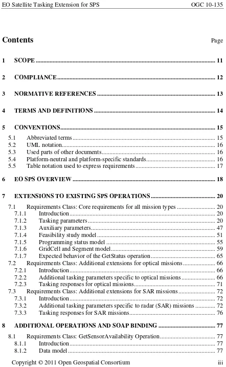
ProgrammingRequest Class
7.1.2.2.1 Description
The ProgrammingRequest class is the root of the list of tasking parameters. It is abstract and cannot be instantiated. Instead, the CoverageProgrammingRequest class (cf. §7.1.2.4) or the SwathProgrammingRequest class (cf. §7.1.2.5) are used.
Requirement
http://www.opengis.net/spec/EOSPS/2.0/req/core/tasking-params-root
7.1.2.2.2 Data model
This abstract class contains two common parameter groups that are inherited by its descendants. These groups are represented by the QualityOfService and
ValidationParameters classes, as shown in the UML diagram below:
«DataType»
ProgrammingRequest
«DataType» QualityOfServ ice
«DataType»
Cov erageProgrammingRequest
«DataType»
ValidationParameters
«DataType» Sw athProgrammingRequest
+QualityOfService 0..1 +ValidationParameters
1..*
Figure 1 – UML diagram of the ProgrammingRequest class
Classes represented in this diagram are fully described in later sections: The class QualityOfService is specified in clause §7.1.2.3.
The class CoverageProgrammingRequest is specified in clause §7.1.2.4. The class SwathProgrammingRequest is specified in clause §7.1.2.5. The class ValidationParameters is specified in clause §7.1.2.16.
7.1.2.3
QualityOfService Class
7.1.2.3.1 Description
If this tasking parameter is supported, the EO-SPS service shall allow at least the two values ‘STANDARD’ and ‘HIGH’ but may provide other mission specific priority levels as well.
Requirement
http://www.opengis.net/spec/EOSPS/2.0/req/core/priority-default
Req 6. The Priority field shall be of type enumeration with at least the two default priority levels ‘STANDARD’ and ‘HIGH’.
Note: A request with a high level of priority can be rejected by the server if the user authorizations don’t allow it (i.e. a user with no special permissions may not be able to get high priority even though he requested it).
All vendor/mission specific extensions related to quality of service should be inserted into this group.
7.1.2.3.2 Data model
This parameter group contains a single PriorityLevel attribute but it provides a container for additional mission specific parameters:
«DataType»
QualityOfServ ice
«property»
«CodeList»
PriorityLev elEnum
«property»
+ PriorityLevel: PriorityLevelEnum + STANDARD: CharacterString + HIGH: CharacterString
Figure 2 – UML diagram of the QualityOfService class
Name Description Type (unit)
PriorityLevel Requested priority level: STANDARD or HIGH,
+ other mission specific levels (e.g. P0, P1 in the example below)…
CodeList
STANDARD, HIGH
7.1.2.3.3 SWE Common encoding
Field Name Definition Component QualityOfService http://www.opengis.net/def/property/OGC-EO/0/QualityOfService DataRecord
PriorityLevel http://www.opengis.net/def/property/OGC-EO/0/PriorityLevel Category
In the following XML snippet, two additional mission specific priority levels have been defined and can thus be used in tasking requests:
<swe:field name="QualityOfService">
<swe:DataRecord definition="http://www.opengis.net/def/property/OGC-EO/0/QualityOfService">
<gml:name>Quality of Service</gml:name>
<swe:field name="PriorityLevel">
<swe:Category definition="http://www.opengis.net/def/property/OGC-EO/0/PriorityLevel">
<swe:constraint>
<swe:AllowedTokens>
<swe:value>STANDARD</swe:value>
<swe:value>HIGH</swe:value> <swe:value>P0</swe:value> <swe:value>P1</swe:value>
</swe:AllowedTokens>
</swe:constraint>
<swe:value>STANDARD</swe:value>
</swe:Category>
</swe:field> </swe:DataRecord> </swe:field>
7.1.2.4
CoverageProgrammingRequest Class
7.1.2.4.1 Description
A CoverageProgrammingRequest is used for tasking a satellite based on an area and period of interest. It is thus adapted to end users who may not know the details of the satellite and remote sensing instrument being tasked. It is also useful to allow tasking a constellation of satellites since the SwathProgrammingRequest is not applicable in this case. Alternatively, a SwathProgrammingRequest can be used (if supported by the server) to request an acquisition from a single satellite based on orbit related criteria (lower level tasking).
7.1.2.4.2 Data model
ProgrammingRequest
+ SurveyPeriod: TM_Period [1..*] + TimeSeries: TimeSeries
Figure 3 – UML diagram of the CoverageProgrammingRequest class
The RegionOfInterest class is specified in §7.1.2.6. Only one region of interest can be specified. Multiple requests should be issued if the coverage of several regions is desired. The TimeOfInterest class is specified in §7.1.2.7. Only one time of interest can be specified but can consist of a list of time period if supported by the server.
The AcquisitionType class is specified in §7.1.2.9.
Note: Time series are used for requesting multiple acquisitions at different dates, whereas specifying several survey periods means only one acquisition, made during one of the several possible periods.
7.1.2.4.3 SWE Common encoding
The following XML snippet shows the skeleton of tasking parameters to be used for the definition of a CoverageProgrammingRequest. The content of each “field” element has been hidden for clarity and is shown in details in later sections:
Field Name Definition Component
CoverageProgramm ingRequest
http://www.opengis.net/def/property/OGC-EO/0/CoverageProgrammingRequest DataRecord
<DescribeTaskingResponse
xmlns="http://www.opengis.net/sps/2.0" xmlns:swe="http://www.opengis.net/swe/2.0">
<taskingParameters name="CoverageProgrammingRequest">
<swe:DataRecord definition="http://www.opengis.net/def/property/OGC-EO/0/CoverageProgrammingRequest">
<swe:field name="QualityOfService" ... />
<swe:field name="RegionOfInterest" ... />
<swe:field name="TimeOfInterest" ... />
<swe:field name="ValidationParameters" ... />
</swe:DataRecord> </taskingParameters> </DescribeTaskingResponse>
7.1.2.5
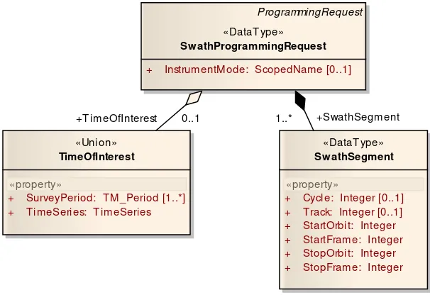
SwathProgrammingRequest Class
7.1.2.5.1 Description
A SwathProgrammingRequest is used to provide low level tasking capabilities based directly on orbit, track and frame numbers. This is usually restricted to advanced users since it requires a-priori knowledge (i.e. technical knowledge of the orbit characteristics) of the mission being tasked.
Moreover, this tasking mode is not applicable to a “virtual” SPS offering representing several missions and allowing the collaborative tasking of different EO instruments on several platforms. This is because a coherent multi-mission programming request is not possible when supplying orbit related information, each mission having a different orbit cycle. A SwathProgrammingRequest is thus inherently single-mission and single-sensor. 7.1.2.5.2 Data model
A SwathProgrammingRequest consists of an optional time of interest (i.e. either a simple time period or a time series) and a list of swath segments to acquire. These segments are identified by their orbit, track and frame numbers and are requested to take place either within a precise orbit cycle or at any time during a certain time period. This is shown on the UML diagram below:
ProgrammingRequest
«DataType»
Sw athProgrammingRequest
+ InstrumentMode: ScopedName [0..1]
«DataType»
+ SurveyPeriod: TM_Period [1..*] + TimeSeries: TimeSeries
0..1 1..*
When a TimeOfInterest is specified, segments can be acquired during any cycle within the temporal window requested. Consequently the Cycle attribute of each requested segment shall be ommited. When no TimeOfInterest is provided, the Cycle attribute shall be included in each segment and the planning system shall try to acquire (or compute the feasibility for) all exact segments requested.
The TimeOfInterest class is specified in §7.1.2.7.
A list of swath segments is used to request the acquisition of one or more portions of imagery swath. The table below further describes individual attributes of the
SwathSegment class:
7.1.2.5.3 SWE Common encoding
The following table describes how this tasking parameters group shall be encoded using the SWE Common Data Model:
Field Name Definition Component
SwathProgramming Request
http://www.opengis.net/def/property/OGC-EO/0/SwathProgrammingRequest DataRecord
InstrumentMode http://www.opengis.net/def/property/OGC-EO/0/InstrumentMode Category
SwathSegmentList http://www.opengis.net/def/property/OGC-EO/0/SwathSegmentList DataArray
SwathSegment http://www.opengis.net/def/property/OGC-EO/0/SwathSegment DataRecord
Cycle http://www.opengis.net/def/property/OGC-EO/0/Cycle Count Requirement
http://www.opengis.net/spec/EOSPS/2.0/req/core/swath-request-time
Req 7. An instance of the SwathProgrammingRequest shall either include a TimeOfInterest as the absolute time period of interest when provided, or set the Cycle attribute on each individual SwathSegment otherwise.
Name Description Type
(unit) Cycle Absolute orbit cycle number during which to acquire the requested imagery
segment. The first cycle usually starts shortly after the platform is launched and it has reached its nominal orbit.
Integer
Track Number of the track where the acquisition is requested to be done. (This is only necessary for satellites that can be pointed off-nadir or with multiple parallel acquisition swaths).
Integer
StartOrbit Number of the orbit (within the cycle) where the acquisition is requested to start. Integer
StartFrame Number of the frame (within the orbit) where the acquisition is requested to start. Integer
StopOrbit Number of the orbit (within the cycle) where the acquisition is requested to stop. Integer
Track http://www.opengis.net/def/property/OGC-EO/0/Track Count
StartOrbit http://www.opengis.net/def/property/OGC-EO/0/StartOrbit Count
StartFrame http://www.opengis.net/def/property/OGC-EO/0/StartFrame Count
StopOrbit http://www.opengis.net/def/property/OGC-EO/0/StopOrbit Count
StopFrame http://www.opengis.net/def/property/OGC-EO/0/StopFrame Count
Values of orbit, track and frame numbers can be further restricted in the
DescribeTaskingResponse corresponding to a given service offering (i.e. for a given mission). This is shown on the following XML snippet that indicates how a
SwathProgrammingRequest shall be encoded with the SWE Common Data Model:
<DescribeTaskingResponse>
<taskingParameters name="SwathProgrammingRequest">
<swe:DataRecord definition="http://www.opengis.net/def/property/OGC-EO/0/SwathProgrammingRequest">
<swe:field name="InstrumentMode">
<swe:Category definition="http://www.opengis.net/def/property/OGC-EO/0/InstrumentMode">
<gml:name>Instrument Mode</gml:name>
<swe:codeSpace xlink:href="http://www.opengis.net/def/property/OGC-EO/0/opt/SpectralModes/"/>
<swe:constraint>
<swe:DataArray definition="http://www.opengis.net/def/property/OGC-EO/0/SwathSegmentList">
<swe:elementCount>
<swe:Count/>
</swe:elementCount>
<swe:elementType name="SwathSegment">
<swe:DataRecord definition="http://www.opengis.net/def/property/OGC-EO/0/SwathSegment">
<swe:field name="Cycle">
<swe:Count definition="http://www.opengis.net/def/property/OGC-EO/0/StartOrbit">
<swe:constraint>
<swe:Count definition="http://www.opengis.net/def/property/OGC-EO/0/StartFrame">
<gml:name>Stop Frame Number</gml:name>
<swe:Count definition="http://www.opengis.net/def/property/OGC-EO/0/StopOrbit">
<gml:name>Stop Orbit Number</gml:name>
<swe:Count definition="http://www.opengis.net/def/property/OGC-EO/0/StopFrame">
<gml:name>Stop Frame Number</gml:name>
When a TimeOfInterest is supported by the service, an additional field is included as shown in the second example below (The content of each field has been omitted for clarity):
<DescribeTaskingResponse>
<taskingParameters name="SwathProgrammingRequest">
<swe:DataRecord definition="http://www.opengis.net/def/property/OGC-EO/0/SwathProgrammingRequest">
<swe:field name="TimeOfInterest" ... /> <swe:field name="InstrumentMode" ... />
<swe:field name="SwathSegmentList" ... />
</swe:DataRecord> </taskingParameters> </DescribeTaskingResponse>
7.1.2.6
RegionOfInterest Class
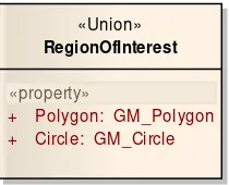
7.1.2.6.1 Description
This class is used within a CoverageProgrammingRequest to specify the desired geographical region of interest that should be covered by the satellite. A user may specify the RegionOfInterest by using either a polygon or a circle. This parameter is mandatory in all EO-SPS tasking requests and shall be supported by all service instances.
7.1.2.6.2 Data model
The RegionOfInterest class is a union of the GM_Polygon and GM_Circle classes defined in [ISO 19107]:
«Union»
RegionOfInterest
«property»
+ Polygon: GM_Polygon + Circle: GM_Circle
Figure 5 – UML diagram of the RegionOfInterest class
7.1.2.6.3 SWE Common encoding of RegionOfInterest
The following table and XML snippet describe how this tasking parameter shall be encoded using the SWE Common Data Model:
Field Name Definition Component
RegionOfInterest http://www.opengis.net/def/property/OGC-EO/0/RegionOfInterest DataChoice
The following example shows the skeleton of the RegionOfInterest parameter definition if the server wants to offer the choice of specifying the ROI via a polygon or a circle:
<swe:field name="RegionOfInterest">
<swe:DataChoice definition="http://www.opengis.net/def/property/OGC-EO/0/RegionOfInterest">
<gml:name>Region of Interest</gml:name>
<swe:item name="Polygon" ... />
<swe:item name="Circle" ... /> </swe:DataChoice>
</swe:field>
Alternatively, it may be too complex or not desired for an EO-SPS to support a choice between polygon and circle. It is then possible for servers to allow the specification of the region of interest by polygon only or circle only. This is done by using a DataRecord
<swe:field name="RegionOfInterest">
<swe:DataRecord definition="http://www.opengis.net/def/property/OGC-EO/0/RegionOfInterest">
<gml:name>Region of Interest</gml:name>
<swe:field name="Polygon" ... /> </swe:DataRecord>
</swe:field>
The contents of the Polygon and Circle elements have been hidden for clarity and are detailed in sections §7.1.2.6.4 and §7.1.2.6.5 respectively.
7.1.2.6.4 SWE Common encoding of GM_Polygon
The GM_Polygon class shall be encoded in SWE Common as indicated by the table and XML snippet below:
Field Name Definition Component
Polygon http://www.opengis.net/def/objectType/ISO-19107/2003/GM_Polygon DataRecord
Exterior http://www.opengis.net/def/objectType/ISO-19107/2003/GM_Ring DataArray
Point No definition required but the coordinates unit shall be ‘deg’ and the reference frame ‘http://www.opengis.net/def/crs/EPSG/0/4326’ shall be specified
Vector
<swe:item name="Polygon">
<swe:DataRecord definition="http://www.opengis.net/def/objectType/ISO-19107/2003/GM_Polygon">
<swe:field name="Exterior">
<swe:DataArray definition="http://www.opengis.net/def/objectType/ISO-19107/2003/GM_Ring">
<swe:elementCount>
<swe:Count/>
</swe:elementCount>
<swe:elementType name="Point">
<swe:Vector referenceFrame="http://www.opengis.net/def/crs/EPSG/0/4326">
<swe:coordinate name="Lat">
<swe:Quantity definition="http://www.opengis.net/def/property/OGC/0/GeodeticLatitude" axisID="Lat">
<swe:uom code="deg"/>
</swe:Quantity>
</swe:coordinate>
<swe:coordinate name="Lon">
7.1.2.6.5 SWE Common encoding of GM_Circle
The GM_Circle class shall be encoded in SWE Common as indicated by the table and XML snippet below:
Field Name Definition Component
Circle http://www.opengis.net/def/objectType/ISO-19107/2003/GM_Circle DataRecord
Center No definition required but the coordinates unit shall be ‘deg’ and the reference frame ‘http://www.opengis.net/def/crs/EPSG/0/4326’ shall be specified
Vector
Radius http://www.opengis.net/def/property/OGC-EO/0/Radius Unit of measure shall be ‘km’ for kilometers
Quantity
<swe:item name="Circle">
<swe:DataRecord definition="http://www.opengis.net/def/objectType/ISO-19107/2003/GM_Circle">
<swe:field name="Center">
<swe:Vector referenceFrame="http://www.opengis.net/def/crs/EPSG/0/4326">
<swe:coordinate name="Lat">
<swe:Quantity definition="http://www.opengis.net/def/property/OGC/0/GeodeticLatitude" axisID="Lat">
<swe:uom code="deg"/>
</swe:Quantity>
</swe:coordinate>
<swe:coordinate name="Lon">
<swe:Quantity definition="http://www.opengis.net/def/property/OGC/0/Longitude" axisID="Long">
<swe:Quantity definition="http://www.opengis.net/def/property/OGC-EO/0/Radius">
<swe:uom code="km"/>
</swe:Quantity>
</swe:field> </swe:DataRecord> </swe:item>
7.1.2.7
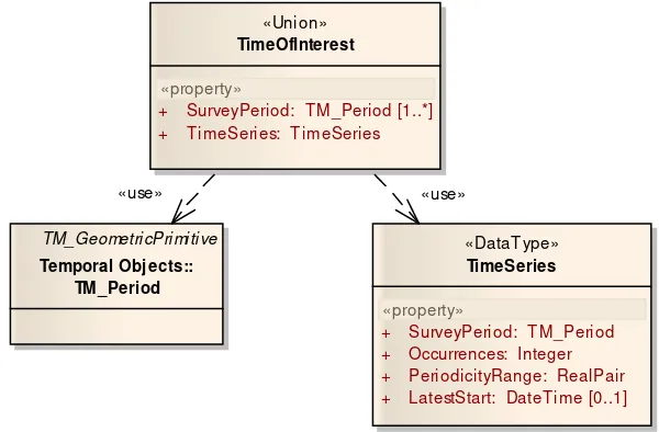
TimeOfInterest Class
7.1.2.7.1 Description
This parameter is used to specify the desired period(s) of acquisition. A TimeOfInterest
may be specified either by one or more time periods (TM_Period) or by a single
Specifying multiple time periods has a different meaning that a time series. In addition to the fact that these periods can be irregularly spaced, a request with several time periods indicates that only one acquisition has to be done within any of the specified time slots. A time series on the other hand corresponds to a request of several acquisitions of the same area at regular intervals. Consequently, only one time series can be specified at a time. 7.1.2.7.2 Data model
The TimeOfInterest class conceptually consists of a union of TM_Period and TimeSeries
classes as shown on the following UML diagram:
«DataType»
TimeSeries
«property»
+ SurveyPeriod: TM_Period + Occurrences: Integer + PeriodicityRange: RealPair + LatestStart: DateTime [0..1] «Union»
TimeOfInterest
«property»
+ SurveyPeriod: TM_Period [1..*] + TimeSeries: TimeSeries
TM_GeometricPrimitive
Temporal Obj ects:: TM_Period
«use» «use»
Figure 6 – UML diagram of the TimeOfInterest class
The encoding of the TM_Period class is specified in clause §7.1.2.7.4. The class TimeSeries is specified in clause §7.1.2.8.
7.1.2.7.3 SWE Common encoding of TimeOfInterest
The following table and XML snippet describe how this tasking parameter shall be encoded using the SWE Common Data Model:
Field Name Definition Component
TimeOfInterest http://www.opengis.net/def/property/OGC-EO/0/TimeOfInterest DataChoice Requirement
http://www.opengis.net/spec/EOSPS/2.0/req/core/survey-period-mandatory
Below is the skeleton of the TimeOfInterest parameter definition:
<swe:field name="TimeOfInterest">
<swe:DataChoice definition="http://www.opengis.net/def/property/OGC-EO/0/TimeOfInterest">
<gml:name>Time of Interest</gml:name>
<swe:item name="SurveyPeriod" ... />
<swe:item name="TimeSeries" ... /> </swe:DataChoice>
</swe:field>
When the support of time series is not desired, a record with a single field containing a survey period shall be used as shown below:
<swe:field name="TimeOfInterest">
<swe:DataRecord definition="http://www.opengis.net/def/property/OGC-EO/0/TimeOfInterest">
<gml:name>Time of Interest</gml:name>
<swe:field name="SurveyPeriod" ... /> </swe:DataRecord>
</swe:field>
The contents of the SurveyPeriod and TimeSeries elements have been hidden for clarity and are detailed in sections §8.1.1.7.4 and §8.1.1.7.5 respectively.
7.1.2.7.4 SWE Common encoding of TM_Period
The following table and XML snippet describe how this tasking parameter shall be encoded using the SWE Common Data Model:
Field Name Definition Component
SurveyPeriod http://www.opengis.net/def/property/OGC-EO/0/SurveyPeriod The unit of measure SHALL be ‘http://www.opengis.net/def/uom/ ISO-8601/0/Gregorian’ to indicate that the time will have to be encoded using ISO 8601 units and format.
TimeRange
<swe:item name="SurveyPeriod">
<swe:TimeRange definition="http://www.opengis.net/def/property/OGC-EO/0/SurveyPeriod">
<gml:name>Survey Period</gml:name>
<swe:uom xlink:href="http://www.opengis.net/def/uom/ISO-8601/0/Gregorian"/> </swe:TimeRange>
</swe:item>
7.1.2.8
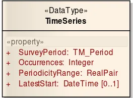
TimeSeries Class
7.1.2.8.1 Description
7.1.2.8.2 Data model
The TimeSeries class contains an overall survey period during which all acquisitions must take place and additional attributes that define the number of occurrences, the periodicity and the latest start date of the series. These attributes are described in more details in the table below:
«DataType»
TimeSeries
«property»
+ SurveyPeriod: TM_Period + Occurrences: Integer + PeriodicityRange: RealPair + LatestStart: DateTime [0..1]
Figure 7 – UML diagram of the TimeSeries class
Name Description Type (unit)
SurveyPeriod Overall period during which the whole series should be acquired, while the latest start, if supported, specifies the date before which the first acquisition of the series must be completed.
TM_Period
Occurences Number of times the region should be fully covered. Integer
PeriodicityRange* Acceptable periodicity range for the temporal series (see note below). This allows for a fine grained specification of the time series periodicity ranging from a loose time interval (e.g. between 4 and 8 weeks) to a very precise period (e.g. exactly 10 days).
RealPair (days)
LatestStart Date before which the first set of acquisitions (i.e. the whole ROI coverage in the case of a CoverageProgrammingRequest or all the requested swath segments in the case of a SwathProgrammingRequest) should be completed.
DateTime
* The periodicity range provides a flexible mechanism to support strict time series (i.e. with an exact periodicity), as well as series with “frozen days” specifying a minimum duration between two successive acquisition of the series. The period is inclusive.
- An exact periodicity is supported by indicating a tight range. It is specified in number of days. For example the following range [1 1] indicates that the periodicity should be EXACTLY 1 day.
- A number of frozen days can be indicated by only specifying the lower bound of the range. For example, [30 +Inf] means that the period between two successive acquisitions must be AT LEAST 30 days, but can be arbitrary larger, as long as the whole series can be completed within the survey period.
acquisitions must be BETWEEN 10 and 20 days, thus leaving more flexibility to the satellite operator, when a strict time series is not really required.
The attributes of the TimeSeries class shall satisfy an additional constraint since the total duration of the survey period cannot be less than the sum of all intervals between successive acquisitions.
7.1.2.8.3 SWE Common encoding
The following table and XML snippet describe how this tasking parameters group shall be encoded using the SWE Common Data Model:
Field Name Definition Component
TimeSeries http://www.opengis.net/def/property/OGC-EO/0/TimeSeries DataRecord
SurveyPeriod http://www.opengis.net/def/property/OGC-EO/0/SurveyPeriod The unit SHALL be ‘ http://www.opengis.net/def/uom/ISO-8601/0/Gregorian’ to indicate that the time will have to be encoded using ISO 8601 units and format.
TimeRange
Occurences http://www.opengis.net/def/property/OGC-EO/0/Occurences Count
PeriodicityRange http://www.opengis.net/def/property/OGC-EO/0/PeriodicityRange QuantityRange
LatestStart http://www.opengis.net/def/property/OGC-EO/0/LatestStart The unit SHALL be ‘ http://www.opengis.net/def/uom/ISO-8601/0/Gregorian’ to indicate that the time will have to be encoded using ISO 8601 units and format.
Time
<swe:item name="TimeSeries">
<swe:DataRecord definition="http://www.opengis.net/def/property/OGC-EO/0/TimeSeries">
<swe:field name="SurveyPeriod">
<swe:TimeRange definition="http://www.opengis.net/def/property/OGC-EO/0/SurveyPeriod">
<gml:name>Survey Period</gml:name>
<swe:uom xlink:href="http://www.opengis.net/def/uom/ISO-8601/0/Gregorian"/>
</swe:TimeRange>
</swe:field>
<swe:field name="Occurences">
<swe:Count definition="http://www.opengis.net/def/property/OGC-EO/0/Occurences">
<gml:name>Number of Occurences</gml:name>
</swe:Count>
</swe:field>
<swe:field name="PeriodicityRange">
<swe:QuantityRange definition="http://www.opengis.net/def/property/OGC-EO/0/PeriodicityRange">
<gml:name>Acquisition Periodicity Range</gml:name>
<swe:uom code="d"/>
</swe:field>
<swe:field name="LatestStart">
<swe:Time definition="http://www.opengis.net/def/property/OGC-EO/0/LatestStart">
<gml:name>Latest Start</gml:name>
<swe:uom xlink:href="http://www.opengis.net/def/uom/ISO-8601/0/Gregorian"/>
</swe:Time>
</swe:field> </swe:DataRecord> </swe:item>
7.1.2.9
AcquisitionType Class
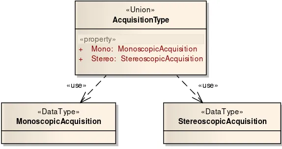
7.1.2.9.1 Description
This parameter is used to specify if the acquisition is monoscopic or stereoscopic, as well as other acquisition parameters.
7.1.2.9.2 Data model
The AcquisitionType class is a union of the MonoscopicAcquisition and
StereoscopicAcquisition classes as shown on the UML diagram below:
«DataType»
MonoscopicAcquisition
«DataType»
StereoscopicAcquisition
«Union»
AcquisitionType
«property»
+ Mono: MonoscopicAcquisition + Stereo: StereoscopicAcquisition
«use» «use»
Figure 8 – UML diagram of the AcquisitionType class
The MonoscopicAcquisition class is specified in clause §7.1.2.10. The StereoscopicAcquisition class is specified in clause §7.1.2.11. 7.1.2.9.3 SWE Common encoding
The following table and XML snippet describe how this tasking parameters group shall be encoded using the SWE Common Data Model:
Field Name Definition Component
The following example shows the skeleton of AcquisitionType parameter definition (the content of MonoscopicAcquisition and StereoscopicAcquisition elements has been hidden for clarity):
<swe:field name="AcquisitionType">
<swe:DataChoice definition="http://www.opengis.net/def/property/OGC-EO/0/AcquisitionType">
<swe:item name="MonoscopicAcquisition" ... />
<swe:item name="StereoscopicAcquisition" ... /> </swe:DataChoice>
</swe:field>
If only one of monoscopic or stereoscopic acquisition types is supported by a given ground segment, the DataChoice shall be replaced by a DataRecord with a single field:
<swe:field name="AcquisitionType">
<swe:DataRecord definition="http://www.opengis.net/def/property/OGC-EO/0/AcquisitionType">
<swe:field name="MonoscopicAcquisition" ... /> </swe:DataRecord>
</swe:field>
7.1.2.10
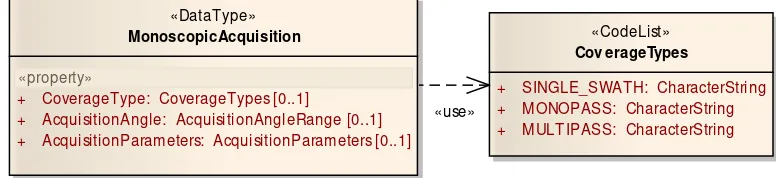
MonoscopicAcquisition Class
7.1.2.10.1 Description
This group of parameters is used to provide geometrical characteristics of a monoscopic acquisition. In particular, the look angles (incidence or pointing angles) are provided by this class.
7.1.2.10.2 Data model
The MonoscopicAcquisition class consists of the attributes listed in the UML diagram below:
«DataType»
MonoscopicAcquisition
«property»
«CodeList»
Cov erageTypes
+ SINGLE_SWATH: CharacterString + MONOPASS: CharacterString + MULTIPASS: CharacterString + CoverageType: CoverageTypes [0..1]
+ AcquisitionAngle: AcquisitionAngleRange [0..1] + AcquisitionParameters: AcquisitionParameters [0..1]
«use»
Name Description Type CoverageType Specifies if the imagery should be acquired in one
or multiple passes.
SINGLE_SWATH: The region of interest should be covered by a single segment.
MONOPASS: The region of interest must be covered by one or more segments acquired from the same orbit (some agile satellites can cover large areas even when satisfying this constraint).
MULTIPASS: The region of interest can be covered by using images extracted from several segments acquired at different dates provided that they are all acquired within the requested time period.
CodeList
SINGLE_SWATH, MONOPASS,
MULTIPASS
AcquisitionAngle Specifies the range of acceptable angles for the acquisition. See section §7.1.2.12 for more details.
AcquisitionParameters Specifies additional requested parameters such as ground resolution, instrument modes, etc. See section §7.1.2.15 for more details.
7.1.2.10.3 SWE Common encoding
The following table and XML snippet describe how this tasking parameters group shall be encoded using the SWE Common Data Model. The AcquisitionAngle and
AcquisitionParameters attributes are not listed in this table as they are detailed in sections §7.1.2.12 and §7.1.2.15 respectively:
Field Name Definition Component
Monoscopic Acquisition
http://www.opengis.net/def/property/OGC-EO/0/MonoscopicAcquisition DataRecord
CoverageType http://www.opengis.net/def/property/OGC-EO/0/CoverageType Code space shall be “ http://www.opengis.net/def/property/OGC-EO/0/CoverageTypes”
Category
Contents of the AcquisitionAngle and AcquisitionParameters “field” elements are hidden in the XML snippet below for clarity:
<swe:field name="MonoscopicAcquisition">
<swe:DataRecord definition="http://www.opengis.net/def/property/OGC-EO/0/MonoscopicAcquisition">
<swe:field name="CoverageType">
<swe:Category definition="http://www.opengis.net/def/property/OGC-EO/0/CoverageType">
<gml:name>Coverage Type</gml:name>
<swe:codeSpace xlink:href="http://www.opengis.net/def/property/OGC-EO/0/CoverageTypes"/>