Publication Date: 2014-02-26 Approval Date: 2013-12-31 Submission Date: 2013-08-22 Reference number of this Document: OGC 10-140r1 External reference for this document: http://www.opengis.net/doc/IS/WCS-application-profile-earth-observation/1.0
Version:1.0 Category: OGC Interface Standard Editor: Peter Baumann, Stephan Meissl, Jinsongdi Yu
OGC® Web Coverage Service 2.0 Interface Standard -
Earth Observation Application Profile
Copyright © 2014 Open Geospatial Consortium.
To obtain additional rights of use, visit http://www.opengeospatial.org/legal/.
Warning
This document is an OGC Member approved international standard. This document is available on a royal-ty free, non-discriminatory basis. Recipients of this document are invited to submit, with their comments, notification of any relevant patent rights of which they are aware and to provide supporting documentation.
Document type: OGC Implementation Standard Document subtype: Interface
Permission is hereby granted by the Open Geospatial Consortium, ("Licensor"), free of charge and subject to the terms set forth below, to any person obtaining a copy of this Intellectual Property and any associated documentation, to deal in the Intellectual Property without restriction (except as set forth below), including without limitation the rights to implement, use, copy, modify, merge, publish, distribute, and/or sublicense copies of the Intellectual Property, and to permit persons to whom the Intellectual Property is furnished to do so, provided that all copyright notices on the intellectual property are retained intact and that each person to whom the Intellectual Property is furnished agrees to the terms of this Agreement.
If you modify the Intellectual Property, all copies of the modified Intellectual Property must include, in addition to the above copy-right notice, a notice that the Intellectual Property includes modifications that have not been approved or adopted by LICENSOR.
THIS LICENSE IS A COPYRIGHT LICENSE ONLY, AND DOES NOT CONVEY ANY RIGHTS UNDER ANY PATENTS THAT MAY BE IN FORCE ANYWHERE IN THE WORLD.
THE INTELLECTUAL PROPERTY IS PROVIDED "AS IS", WITHOUT WARRANTY OF ANY KIND, EXPRESS OR IMPLIED, INCLUDING BUT NOT LIMITED TO THE WARRANTIES OF MERCHANTABILITY, FITNESS FOR A PARTICULAR PURPOSE, AND NONINFRINGEMENT OF THIRD PARTY RIGHTS. THE COPYRIGHT HOLDER OR HOLDERS INCLUDED IN THIS NOTICE DO NOT WARRANT THAT THE FUNCTIONS CONTAINED IN THE INTELLECTUAL PROPERTY WILL MEET YOUR REQUIREMENTS OR THAT THE OPERATION OF THE INTELLECTUAL PROPERTY WILL BE
UNINTERRUPTED OR ERROR FREE. ANY USE OF THE INTELLECTUAL PROPERTY SHALL BE MADE ENTIRELY AT THE USER’S OWN RISK. IN NO EVENT SHALL THE COPYRIGHT HOLDER OR ANY CONTRIBUTOR OF
INTELLECTUAL PROPERTY RIGHTS TO THE INTELLECTUAL PROPERTY BE LIABLE FOR ANY CLAIM, OR ANY DIRECT, SPECIAL, INDIRECT OR CONSEQUENTIAL DAMAGES, OR ANY DAMAGES WHATSOEVER RESULTING FROM ANY ALLEGED INFRINGEMENT OR ANY LOSS OF USE, DATA OR PROFITS, WHETHER IN AN ACTION OF CONTRACT, NEGLIGENCE OR UNDER ANY OTHER LEGAL THEORY, ARISING OUT OF OR IN CONNECTION WITH THE IMPLEMENTATION, USE, COMMERCIALIZATION OR PERFORMANCE OF THIS INTELLECTUAL PROPERTY.
This license is effective until terminated. You may terminate it at any time by destroying the Intellectual Property together with all copies in any form. The license will also terminate if you fail to comply with any term or condition of this Agreement. Except as provided in the following sentence, no such termination of this license shall require the termination of any third party end-user subli-cense to the Intellectual Property which is in force as of the date of notice of such termination. In addition, should the Intellectual Property, or the operation of the Intellectual Property, infringe, or in LICENSOR’s sole opinion be likely to infringe, any patent, copyright, trademark or other right of a third party, you agree that LICENSOR, in its sole discretion, may terminate this license with-out any compensation or liability to you, your licensees or any other party. You agree upon termination of any kind to destroy or cause to be destroyed the Intellectual Property together with all copies in any form, whether held by you or by any third party.
Except as contained in this notice, the name of LICENSOR or of any other holder of a copyright in all or part of the Intellectual Prop-erty shall not be used in advertising or otherwise to promote the sale, use or other dealings in this Intellectual PropProp-erty without prior written authorization of LICENSOR or such copyright holder. LICENSOR is and shall at all times be the sole entity that may author-ize you or any third party to use certification marks, trademarks or other special designations to indicate compliance with any LICENSOR standards or specifications.
iii Copyright © 2014 Open Geospatial Consortium
Contents
Page
1
Scope ... 1
2
Conformance ... 1
3
Normative references ... 1
4
Terms and definitions ... 3
5
Conventions ... 4
6
EO data model ... 5
7
EO service model ... 15
8
WCS extensions ... 31
9
Protocol Bindings ... 32
Bibliography ... 35
Annex A (normative) Abstract test suite ... 36
Annex B (normative) Transitional provisions ... 68
Annex C (informative) Use Case examples ... 69
iv Copyright © 2014 Open Geospatial Consortium
Tables
PageTable 1 — Namespace mappings ... 4
Table 2 — Components of EOWCS::EOMetadata structure ... 7
Table 3 — Components of EOWCS::ReferenceableStitchedMosaic structure ... 11
Table 4 — Components of EOWCS::RectifiedStitchedMosaic structure ... 11
Table 5 — Components of EOWCS::DatasetReference structure ... 11
Table 6 — Components of EOWCS::DatasetSeries structure ... 14
Table 7 — Components of EOWCS::DatasetSeriesSummary structure ... 17
Table 8 — Values for CoverageSubtype elements of EO Coverages ... 18
Table 9 — Values for ows:Constraint elements ... 19
Table 10 — Components of DescribeEOCoverageSet operation request ... 26
Table 11 — Components of EOCoverageSetDescription structure ... 27
v Copyright © 2014 Open Geospatial Consortium
i.
Abstract
The OGC Web Coverage Service (WCS) Application Profile – Earth Observation (EO-WCS), defines a profile of WCS 2.0 [OGC 09-110r4] for use on Earth Observation data. Suggested additions, changes, and comments on this draft document are welcome and en-couraged. Such suggestions may be submitted by email message or by making suggested changes in an edited copy of this document.
ii.
Keywords
ogcdoc, wcs, profile, eo
iii.
Terms and definitions
This document uses the standard terms defined in Subclause 5.3 of [OGC 06-121r9], which is based on the ISO/IEC Directives, Part 2, Rules for the structure and drafting of International Standards. In particular, the word “shall” (not “must”) is the verb form used to indicate a requirement to be strictly followed to conform to this standard.
iv.
Submitting organizations
The following organizations have submitted this Interface Specification to the Open GeoSpa-tial Consortium, Inc.:
Jacobs University Bremen EOX IT Services GmbH
G.I.M. Geographic Information Management nv/sa European Space Agency (ESA)
Spot Image
Additionally, rasdaman GmbH has made substantial contributions.
v.
Document Contributor Contact Points
vi.
Changes to the OGC
®Abstract Specification
The OGC® Abstract Specification does not require any changes to accommodate the technical contents of this (part of this) document.
Name Organization
Peter Baumann Jacobs University Bremen, rasdaman GmbH Jinsongdi Yu Jacobs University Bremen
vi Copyright © 2014 Open Geospatial Consortium
vii.
Future Work
Among the topics for future development are the following items:
Allow additional coverage representations (i.e., “multipart” and “special format” cov-erage encodings) once these are adopted for the GML Application Schema for Cover-ages [OGC 09-146].
Extend the current 2-D EO Coverage footprint to 3-D footprints by extending them with elevation; this will involve extending footprints from bounding multi-curves (polygons) to multi-surfaces.
Specify usage and content of EOWCS::Lineage in more detail.
vii Copyright © 2014 Open Geospatial Consortium
Foreword
This WCS Application Profile for Earth Observation is an OGC Interface Standard which relies on WCS 2.0 (the Core [OGC 09-110r4] plus selected extensions), the GML Applica-tion Schema for Coverages [OGC 09-146r2], the Earth ObservaApplica-tion Metadata Profile of Ob-servations and Measurements [OGC 10-157r3], and GML 3.2.1 [OGC 07-036].
This document includes three annexes; the first two annexes are normative.
Attention is drawn to the possibility that some of the elements of this document may be the subject of patent rights. The Open Geospatial Consortium shall not be held responsible for identifying any or all such patent rights.
viii Copyright © 2014 Open Geospatial Consortium
Introduction
The OGC Web Coverage Service (WCS) Application Profile – Earth Observation (EO-WCS), defines a profile of WCS 2.0 [OGC 09-110r4] for use on Earth Observation data. An Application Profile bundles several specifications and possibly adds additional requirements on an implementation. Extra requirements can be additions (for example, Dataset Series are introduced by this specification) or constraints (for example, coverages offered are restricted to 2-D rasters).
EO-WCS provides the following specification elements:
Definition of specific Earth Observation coverages (EO Coverages) which have a lat-itude/longitude or projected x/y spatial extent and a temporal validity extent. EO Coverages are derived from Referenceable Grid Coverages and Rectified Grid Cov-erages as defined in the GML Application Schema for CovCov-erages [OGC 09-146r2]. Each EO Coverage has an EO metadata set [OGC 10-157r3] contained in its metadata which describes the coverage on hand on a higher semantic level.
Definition of a hierarchy which allows to group EO Coverages suitably for an effi-cient retrieval:
Datasets as plain 2-D EO Coverages (and, hence, accessible as coverages); Stitched Mosaics as homogeneous collections of spatially non-overlapping
sub-sets of Datasub-sets, accessible themselves as coverages;
Dataset Series as collections of Stitched Mosaics, Datasets, and/or Dataset Series; Dataset Series themselves are not coverages.
1 Copyright © 2014 Open Geospatial Consortium
OGC® Web Coverage Service 2.0 Interface Standard –
Earth Observation Application Profile
1 Scope
This OGC WCS Application Profile – Earth Observation Interface Standard – henceforth abbreviated as: WCS Earth Observation Application Profile (EO-WCS) – defines data struc-tures and operations which together allow retrieval of Earth Observation coverages offered by a WCS 2.0 server.
2 Conformance
This document establishes the following requirements and conformance classes: eowcs, of URI
http://www.opengis.net/spec/WCS_application-profile_earth-observation/1.0/req/eowcs, defining EO-WCS on conceptual level in Clauses 6, 7, and 8; the corresponding conformance class is eowcs, with URI
http://www.opengis.net/spec/WCS_application-profile_earth-observation/1.0/conf/eowcs.
eowcs_get-kvp, of URI http://www.opengis.net/spec/WCS_application-profile_earth-observation/1.0/req/eowcs_get-kvp, defining the GET-KVP protocol binding of EO-WCS in Subclause 9.2; the corresponding conformance class is eowcs_get-kvp, with URI
http://www.opengis.net/spec/WCS_application-profile_earth-observation/1.0/conf/eowcs_get-kvp.
eowcs_soap, of URI http://www.opengis.net/spec/WCS_application-profile_earth-observation/1.0/req/eowcs_soap, defining the SOAP protocol binding of EO-WCS on conceptual level in Subclause 9.3; the corresponding conformance class is
eowcs_soap, with URI http://www.opengis.net/spec/WCS_application-profile_earth-observation/1.0/conf/eowcs_soap.
Standardisation target of all requirements and conformance classes are EO-WCS implemen-tations (currently: servers).
Requirements and conformance test URIs defined in this document are relative to http://www.opengis.net/spec/WCS_application-profile_earth-observation/1.0/.
Annex A lists the conformance tests which shall be exercised on any software artefact claim-ing to implement EO-WCS.
3 Normative references
2 Copyright © 2014 Open Geospatial Consortium has OGC URI
http://www.opengis.net/doc/ISx/WCS_application-profile_earth-observation/1.0.
The complete specification is available for download from
http://www.opengeospatial.org/standards/wcs; additionally, the XML Schema is posted online at http://schemas.opengis.net/wcs/wcseo/1.0 as part of the OGC schema repository. In the event of a discrepancy between bundled and schema repository versions of the XML Schema files, the schema repository shall be considered authoritative.
The following normative documents contain provisions that, through reference in this text, constitute provisions of this specification. For dated references, subsequent amendments to, or revisions of, any of these publications do not apply. For undated references, the latest edi-tion of the normative document referred to applies.
OGC 06-121r9 OGC Web Services Common Standard, version 2.0
OGC 09-146r2, GML 3.2.1 Application Schema for Coverages, version 1.0 Conformance classes used:
gml-coverage
OGC 09-110r4, OGC® Web Coverage Service 2.0 Interface Standard Core, version 2.0 Conformance classes used:
core
OGC 11-053, OGC® WCS 2.0 Interface Standard – CRS Service Model Extension, version 1.0
Conformance classes used: crs
OGC 12-039, OGC® WCS 2.0 Interface Standard – Scaling Service Model Extension, ver-sion 1.0
Conformance classes used: scaling
OGC 12-040, OGC® WCS 2.0 Interface Standard – Range Subsetting Service Model Exten-sion, version 1.0
Conformance classes used: range-subsetting
OGC 12-049, OGC® WCS 2.0 Interface Standard – Interpolation Service Model Extension, version 1.0
Conformance classes used: interpolation
OGC 09-147r3, OGC® WCS 2.0 Interface Standard – KVP Protocol Binding Extension, version 1.0
3 Copyright © 2014 Open Geospatial Consortium OGC 09-149r1, OGC® WCS 2.0 Interface Standard – SOAP Protocol Binding Extension, version 1.0
Conformance classes used: soap
OGC 12-100r1, OGC® GML Application Schema – Coverages – GeoTIFF Coverage En-coding Profile, version 1.0
Conformance classes used: geotiff-coverage
OGC 11-010, OGC® WCS 2.0 Interface Standard – NetCDF Encoding Format Extension, version 1.0
Conformance classes used: netcdf
OGC 11-011, OGC® WCS 2.0 Interface Standard – JPEG2000 Encoding Format Extension, version 1.0
Conformance classes used: jpeg2000
OGC 10-157r3, Earth Observation Metadata Profile of Observations and Measurements Conformance classes used:
eop, sar, opt
NOTE Annex B lists transitional provisions until all of the above specifications are available as adopt-ed OGC documents.
4 Terms and definitions
For the purposes of this document, the terms and definitions given in the above references apply. In addition, the following terms and definitions apply. An arrow “” indicates that the following term is defined in this Clause.
4.1 Coverage
digital representation of a spatio-temporally varying phenomenon as defined in [OGC 09-146r2]
4.2 Dataset
2-D EO Coverage
NOTE A Dataset usually represents observations obtained by satellite instruments. 4.3 Dataset Series
4 Copyright © 2014 Open Geospatial Consortium 4.4 EO Coverage
Rectified Grid Coverage or Referenceable Grid Coverage having an EO Metadata rec-ord and a WGS84 bounding box
4.5 EO Metadata
EO Coverage’s metadata record
4.6 Stitched Mosaic
EO Coverage composed from subsets of one or more co-referenced Datasets
4.7 Lineage record
Data structure documenting an operation that has been applied to the coverage it is part of
4.8 refers to
contains, in its EO Metadata element as defined in [OGC 10-157r3], the EO Metadata element of
5 Conventions
5.1 UML notation
Unified Modeling Language (UML) static structure diagrams appearing in this specification are used as described in Subclause 5.2 of OGC Web Services Common [OGC 06-121r9]. 5.2 Data dictionary tables
The UML model data dictionary is specified herein in a series of tables. The contents of the columns in these tables are described in Subclause 5.5 of [OGC 06-121r9]. The contents of these data dictionary tables are normative, including any table footnotes.
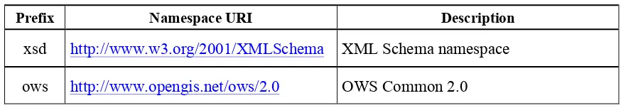
5.3 Namespace prefix conventions
The following namespaces are used in this document. The prefix abbreviations used consti-tute conventions used here, but are not normative. The namespaces to which the prefixes refer are normative, however.
Table 1 — Namespace mappings
Prefix Namespace URI Description
5 Copyright © 2014 Open Geospatial Consortium gml http://www.opengis.net/gml/3.2 GML 3.2.1
gmlcov http://www.opengis.net/gmlcov/1.0 GML Application Schema for Coverag-es 1.0
wcs http://www.opengis.net/wcs/2.0 WCS 2.0
eop http://www.opengis.net/eop/2.0 Earth Observation Metadata Profile of Observations and Measurements opt http://www.opengis.net/opt/2.0 Optical Earth Observation Metadata
Profile of Observations and Measure-ments (extension of eop)
sar http://www.opengis.net/sar/2.0 SAR Earth Observation Metadata Profile of Observations and Measurements (ex-tension of eop)
wcseo http://www.opengis.net/wcs/wcseo/1.0 WCS Application Profile – Earth Obser-vation 1.0
5.4 Multiple representations
When multiple representations of the same information are given in a specification document these are consistent. Should this not be the case then this is considered an error, and the XML schema shall take precedence.
6 EO data model
6.1 Overview
This Clause 6, together with Clauses 7 and 8, establishes the EO-WCS core requirements class, eowcs.
The data model of this EO-WCS centers around the data structure of an Earth Observation coverage (EO Coverage), which is a coverage extended with EO Metadata [OGC 10-157r3] and bound to a location on the Earth. EO Coverages are a subtype of either
GML-COV::RectifiedGridCoverage or GMLCOV::ReferenceableGridCoverage. Based on this EO Coverage concept (cf. Subclause 6.3), three main data elements are de-fined:
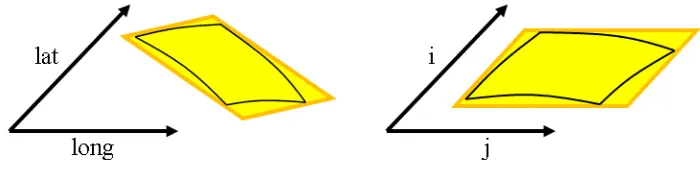
A Dataset is a 2-D horizontal EO Coverage, which can represent, for example, a hy-perspectral satellite scene; cf. Subclause 6.4. A Dataset can be a Rectified Dataset or a Referenceable Dataset, depending on the type of EO Coverage it is derived from. A Stitched Mosaic is a collection of 2-D horizontal EO Coverages referring to
6 Copyright © 2014 Open Geospatial Consortium is derived from. A Stitched Mosaic can be interpreted (i.e. requested) as a single cov-erage.
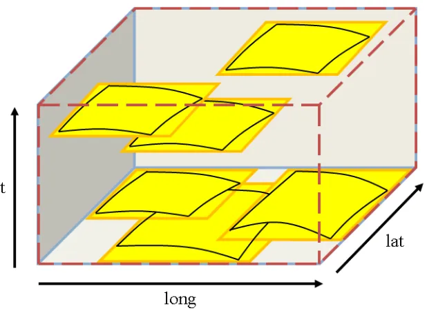
A Dataset Series is a collection of coverages and/or Dataset Series; cf. Subclause 6.6. A Dataset Series can refer to any number of Datasets, Stitched Mosaics, and Da-taset Series. A DaDa-taset Series is not a coverage itself.
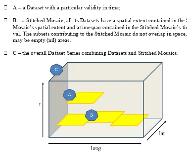
NOTE Annex C provides Use Cases to motivate the definition of these data elements. Figure 1 informally symbolizes how the concepts of Dataset, Stitched Mosaic, and Dataset Series relate to each other spatio-temporally:
A – a Dataset with a particular validity in time;
B – a Stitched Mosaic; all its Datasets have a spatial extent contained in the Stitched Mosaic’s spatial extent and a timespan contained in the Stitched Mosaic’s time inter-val. The subsets contributing to the Stitched Mosaic do not overlap in space, but there may be empty (nil) areas.
C – the overall Dataset Series combining Datasets and Stitched Mosaics.
Figure 1 — Conceptual view of a Dataset Series with Stitched Mosaic and Dataset
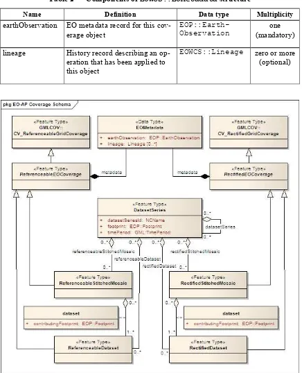
Figure 2 contains the UML diagram defining classes (types) and their correlations in the EO-WCS.
6.2 EO Metadata
7 Copyright © 2014 Open Geospatial Consortium Requirement 1 /req/eowcs/eo-metadata-structure:
A EOWCS::EOMetadata instance shall conform to Table 2, Figure 2, Figure 3, and the XML schema being part of this standard.
Table 2 — Components of EOWCS::EOMetadata structure
Name Definition Data type Multiplicity
earthObservation EO metadata record for this cov-erage object
EOP::Earth-Observation
one (mandatory) lineage History record describing an
op-eration that has been applied to this object
EOWCS::Lineage zero or more (optional)
8 Copyright © 2014 Open Geospatial Consortium NOTE Throughout this standard, eop: and EOP:: can be substituted by opt: and OPT:: or sar: and SAR::, respectively, as in [OGC 10-157r3] opt and sar are in the substitution group of eop.
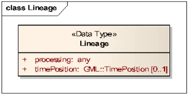
Figure 3 — UML Lineage class diagram
NOTE The lineage records are supposed to describe the history of processing steps that has led to the coverage on hand. As at the time of this writing there is no canonical format for such histories available in OGC, for the purpose of this specification no assumption is made about the contents of a lineage record, except that GetCoverage appends its request verbatim as an additional record (see Requirement 46). The footprint of an EO Coverage, which contains one or more bounding polygons to describe the region of valid data more accurately than the EO Coverage’s bounding box, is mandatory as opposed to [OGC 10-157r3].
Requirement 2 /req/eowcs/footprint-in-eo-metadata:
The EOWCS::EOMetadata element of EOWCS::ReferenceableEOCoverage and
EOWCS::RectifiedEOCoverage instances shall contain an eop:EarthObservat-ion/om:featureOfInterest/eop:Footprint element.
NOTE As per [OGC 10-157r3], the footprint is always given in WGS84. 6.3 EO Coverage
6.3.1 Overview
An EO Coverage is a coverage as defined in the GML Application Schema for Coverages [OGC 09-146r2]. EO Coverages appear in two variants:
Rectified EO Coverages are derived from Rectified Grid Coverage as defined in [OGC 09-146r2];
Referenceable EO Coverages are derived from Referenceable Grid Coverage as de-fined in [OGC 09-146r2].
Requirement 3 /req/eowcs/eo-coverage-structure:
EOWCS::ReferenceableEOCoverage and EOWCS::RectifiedEOCoverage in-stances shall conform to Figure 2, Figure 3, and the XML schema being part of this standard. 6.3.2 EO Metadata
9 Copyright © 2014 Open Geospatial Consortium Requirement 4 /req/eowcs/eo-metadata-in-eo-coverage:
EOWCS::ReferenceableEOCoverage and EOWCS::RectifiedEOCoverage in-stances shall contain one metadata element of type EOWCS::EOMetadata.
NOTE 1 Besides this specific metadata element there may be further metadata elements. NOTE 2 According to the rules of GML, a xlink:href URI to an accessible element of type
EOWCS::EOMetadata can be provided instead of the element itself in any place of the XML schema where such a metadata record appears.
The EO Metadata record associated with an EO Coverage contains a back reference to the coverage.
Requirement 5 /req/eowcs/eop-identifier-in-eo-metadata:
The EOWCS::EOMetadata element of EOWCS::ReferenceableEOCoverage and
EOWCS::RectifiedEOCoverage instances shall contain an element eop:EarthObs-
ervation/eop:metadataProperty/eop:EarthObservationMeta-Data/eop:identifier whose first word (NCNAME type substring i.e. starting from it's first character up to and excluding the first character which is not allowed in an NCName) is identical to the EO Coverage identifier.
NOTE Normally, this word (i.e. NCName) acting as coverage identifier will be the only contents of the eop:identifier string and thus both elements will be equal.
6.3.3 Spatio-temporal extent
The EO Coverage’s extent of valid data is given by its EO Metadata footprint, which refines the coverage’s envelope.
Requirement 6 /req/eowcs/footprint-inside-boundedBy:
In EOWCS::ReferenceableEOCoverage and EOWCS::RectifiedEOCoverage
instances, all polygons listed in eop:EarthObservation/om:featureOfInter-est/eop:Footprint element shall be geometrically contained in the bounding box of the gml:boundedBy element of the gml:Envelope.
NOTE By definition, the footprint is expressed in WGS84. An EO Coverage has a time period of validity associated.
Requirement 7 /req/eowcs/phenomenonTime-in-eo-metadata:
The EOWCS::EOMetadata element of a EOWCS::ReferenceableEOCoverage or
EOWCS::RectifiedEOCoverage instance shall contain elements eop:EarthObserv-ation/om:phenomenonTime/gml:TimePeriod/gml:beginPosition and
eop:EarthObservation/om:phenomenonTime/gml:TimePeriod/gml:end-Position where beginPosition≤endPosition.
NOTE This typically is the time period where image acquisition has taken place. Requirement 8 /req/eowcs/phenomenonTime-iso8601:
10 Copyright © 2014 Open Geospatial Consortium 6.3.4 Range set
Requirement 9 /req/eowcs/range-set-of-eo-coverage:
In EOWCS::ReferenceableEOCoverage and EOWCS::RectifiedEOCoverage in-stances, all cells whose locations are outside the EO Metadata footprint when both are evalu-ated in WGS84, shall contain nil values as defined in the bounding EO Coverage’s range type.
6.4 Dataset
A Dataset is an EO Coverage as symbolized in Figure 4. A Dataset is either a Referenceable Dataset or a Rectified Dataset, derived from EOWCS::ReferenceableEOCoverage or
EOWCS::RectifiedEOCoverage, respectively.
NOTE Typically, a Dataset represents a (single- or multi-band) satellite/aerial image scene. Requirement 10 /req/eowcs/dataset-structure:
A EOWCS::ReferenceableDataset and a EOWCS::RectifiedDataset shall con-form to Figure 2, Figure 3, and the XML schema being part of this standard.
Figure 4 — Conceptual view of a Dataset as a 2-D coverage: in referenced (left) und unreferenced coordinates (right)
NOTE This definition includes the “field-of-View” of a sensor, or “cut”, according to sensor specific data specification at the resolution of the sensor (also referred to as Level-0 or Level-1 data).
6.5 Stitched Mosaic
6.5.1 Overview
A Stitched Mosaic is an identifiable, queryable, referenced EO Coverage as symbolized in Figure 5. A Stitched Mosaic is either a Referenceable Stitched Mosaic or a Rectified Stitched Mosaic, derived from EOWCS::ReferenceableEOCoverage or EOWCS::Rectified-EOCoverage, respectively.
11 Copyright © 2014 Open Geospatial Consortium Figure 5 — Conceptual view of a Stitched Mosaic as a 2-D coverage:
composed from Datasets (Stitched Mosaic bounding box dashed)
Requirement 11 /req/eowcs/referenceableStitcheMosaic-structure:
EOWCS::ReferenceableStitchedMosaic instances shall conform to Figure 2, Fig-ure 3, Table 3, Table 5, and the XML schema being part of this standard.
Table 3 — Components of EOWCS::ReferenceableStitchedMosaic structure
Name Definition Data type Multiplicity
dataset Reference to a Referenceable Dataset re-ferred to by the Stitched Mosaic on hand
EOWCS::Dataset-Reference
one or more (mandatory)
Requirement 12 /req/eowcs/rectifiedStitchedMosaic-structure:
EOWCS::RectifiedStitchedMosaic instances shall conform to Figure 2, Figure 3, Table 4, Table 5, and the XML schema being part of this standard.
Table 4 — Components of EOWCS::RectifiedStitchedMosaic structure
Name Definition Data type Multiplicity
dataset Reference to a Rectified Dataset referred to by the Stitched Mosaic on hand
EOWCS::Dataset-Reference
one or more (mandatory)
Table 5 — Components of EOWCS::DatasetReference structure
Name Definition Data type Multiplicity
datasetId Dataset referred to by the Stitched Mosaic on hand closing data areas of the Dataset contributing to the Stitched Mosaic on hand
EOP::Footprint zero or one (optional)
12 Copyright © 2014 Open Geospatial Consortium Requirement 13 /req/eowcs/composedOf-in-stitched-mosaic:
In EOWCS::ReferenceableStitchedMosaic and EOWCS::RectifiedStitched-Mosaic instances with at least one eop:EarthObservation/eop:metaDataProp-erty/eop:EarthObservationMetaData/eop:composedOf, the set of these ele-ments shall be equal to the set of dataset identifiers of the Stitched Mosaic.
6.5.2 Spatio-temporal extent
A Stitched Mosaic is defined through a collection of spatially non-overlapping subsets of Datasets it refers to.
Requirement 14 /req/eowcs/contributingFootprint-inside-footprint:
For all Stitched Mosaics sm referring to some Datasets d with an associated contrib-utingFootprint, this contributingFootprint shall be geographically contained in the footprint of d.
Requirement 15 /req/eowcs/contributingFootprint-pairwise-disjoint:
For all Stitched Mosaics sm referring to Datasets d1 and d2, with an associated
contrib-utingFootprint, the contributingFootprints of the d1 and d2 references shall be
pair-wise disjoint.
Requirement 16 /req/eowcs/contributingFootprint-union-of-footprints:
The footprint of a Stitched Mosaic shall be given by the union of the contributingFoot-prints of the Datasets this Stitched Mosaic refers to.
Requirement 17 /req/eowcs/dataset-domain-set-in-stitched-mosaic-domain-set: For all Datasets d referred to by some Stitched Mosaics sm, all cells of d as defined by the domain set of d shall be contained in the set of cells of sm as defined by the domain set of sm.
Datasets referred to by a Stitched Mosaic shall have aligned cell locations:
In case of Rectified EO Coverages, the grids of Datasets of a Stitched Mosaics shall have the same resolution.
Requirement 18 /req/eowcs/datasets-in-rectifiedStitcheMosaic-same-offset-Vector:
All Datasets referred to by a Rectified Stitched Mosaic shall have identical values in the gml:offsetVector elements of their domain sets.
Requirement 19 /req/eowcs/rectifiedStitchedMosaic-offsetVector:
In a Rectified Stitched Mosaic instance, the value of the gml:offsetVector ele-ments of the domain set shall be given by the corresponding values of the Rectified Datasets the Rectified Stitched Mosaic refers to.
In case of Referenceable EO Coverages, Datasets of Stitched Mosaics shall have aligned cell locations in overlapping areas.
Requirement 20 /req/eowcs/referenceableStitchedMosaic-domain-set:
13 Copyright © 2014 Open Geospatial Consortium point locations in the geographic overlap of the d1 and d2 domain set shall be
identical.
The temporal validity of Stitched Mosaics is defined by the temporal validities of the Da-tasets the Stitched Mosaic refers to.
Requirement 21 /req/eowcs/temporal-validity-stitched-mosaic:
For any given Stitched Mosaic, its temporal validity given by its eop:EarthObservat-ion/om:phenomenonTime/gml:TimePeriod/gml:beginPosition and
eop:EarthObservation/om:phenomenonTime/gml:TimePeriod/gml:end-Position elements in eowcs:EOMetadata shall be defined as the minimal time interval containing the temporal validities of all Datasets the Stitched Mosaic refers to.
6.5.3 Range type
Stitched Mosaics and their Datasets share the same range type.
Requirement 22 /req/eowcs/datasets-in-stitched-mosaic-same-range-type:
For all Datasets d some Stitched Mosaic sm refers to the following shall hold: The range type of d is identical to the range type of sm.
6.5.4 Range set
The content of a Stitched Mosaic is given by the Datasets it refers to; cells of a Stitched Mo-saic with domain coordinates outside of any embedded Dataset’s contributingFootprint carry nil values (cf. Figure 6).
Requirement 23 /req/eowcs/nil-values-in-stitched-mosaic:
If the domain set of a Stitched Mosaic contains locations which are not inside any contrib-utingFootprint of any Dataset the Stitched Mosaic refers to then the nil value set of that Stitched Mosaic shall not be empty.
Requirement 24 /req/eowcs/range-values-of-stitched-mosaic:
For a Stitched Mosaic sm its range values of cells with location p, expressed in any of the CRSs supported by sm, shall be given as follows:
- if p is located within the contributingFootprint of some Dataset d referred to by sm then it is the range value of d at p;
- if p is not located within the contributingFootprint of any Dataset d referred to by sm then it is one of the range values contained in the nil value set of sm.
6.6 Dataset Series
14 Copyright © 2014 Open Geospatial Consortium Figure 6 — Conceptual view of a Dataset Series referring to Datasets and
Stitched Mosaics (Dataset Series domain boundary dashed)
Requirement 25 /req/eowcs/datasetSeries-structure:
A EOWCS::DatasetSeries shall conform to Figure 2, Figure 3, Table 6, and the XML schema being part of this standard.
Table 6 — Components of EOWCS::DatasetSeries structure
Name Definition Data type Multiplicity
datasetSeriesId Identifier of the Dataset Series on hand
NCName one
(mandatory) footprint Horizontal bounding polygon
enclosing valid data areas of the Dataset Series
EOP::Footprint one
(mandatory)
timePeriod Temporal period of validity of all data in the Dataset Series
GML::TimePeriod one (mandatory)
referenceable-StitchedMosaic
Referenceable Stitched Mosaic to which the Dataset Series on hand refers
WCS::CoverageId zero or more (optional)
rectified-StitchedMosaic
Rectified Stitched Mosaic to which the Dataset Series on hand refers
WCS::CoverageId zero or more (optional)
referenceable-Dataset
Referenceable Dataset to which the Dataset Series on hand refers
15 Copyright © 2014 Open Geospatial Consortium rectifiedDataset Rectified Dataset to which the
Dataset Series on hand refers
WCS::CoverageId zero or more (optional) datasetSeries Dataset Series to which the
Da-taset Series on hand refers
EOWCS::datasetSe riesId
zero or more (optional)
NOTE A Dataset Series and a Stitched Mosaic contained therein may both refer to the same Dataset. The spatial extent of a Dataset Series shall enclose the spatial extents of all Stitched Mosaics, Datasets, and Dataset Series the Dataset Series refers to.
Requirement 26 /req/eowcs/footprint-in-datasetSeries:
The footprint of a Dataset Series instance shall enclose the union of the footprints of all Stitched Mosaics, Datasets, and Dataset Series the Dataset Series refers to, expressed in WGS84.
NOTE As opposed to Stitched Mosaics, Dataset Series do not require disjointness of the EO Coverag-es they refer to.
The temporal validity of a Dataset Series is defined by the union of the temporal validities of all Stitched Mosaics, Datasets, and Dataset Series the Dataset Series refers to.
Requirement 27 /req/eowcs/timePeriod-in-datasetSeries:
For any given Dataset Series, the timePeriod element shall enclose the temporal validities of all Stitched Mosaics, Datasets, and Dataset Series the Dataset Series refers to, expressed in ISO 8601 [2].
A Dataset Series shall not refer to any Dataset Series that refers to it either directly or via other Dataset Series i.e. there shall be no circular references.
Requirement 28 /req/eowcs/nocircularreference-of-datasetSeries:
A Dataset Series shall only refer to Dataset Series that do not refer to the Dataset Series at hand either directly or via other Dataset Series.
7 EO service model
7.1 Overview
This Clause defines request types and their responses for operations on EO Coverages. EO Coverages can be offered by a WCS server alongside with any other type of coverages. Be-havior of the service on non-EO Coverages remains unchanged.
7.2 GetCapabilities operation
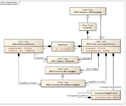
7.2.1 GetCapabilities request
The GetCapabilities request is extended over WCS Core [OGC 09-110r4] as follows: In the sections request parameter, values “DatasetSeriesSummary“ and
16 Copyright © 2014 Open Geospatial Consortium Requirement 29 /req/eowcs/getCapabilities-request-sections:
If a GetCapabilities request contains an ows:Sections element then this element shall con-tain ows:Section elements with the values defined in OWS Common, or
“Dataset-SeriesSummary”, or “CoverageSummary”. Dependency: [OGC 06-121r9] clause 7.3.3
7.2.2 GetCapabilities response
The GetCapabilities response is extended over WCS Core [OGC 09-110r4] as follows: There is an additional DatasetSeriesSummary section reporting identifiers of
Dataset Series offered by the service on hand.
There is an optional constraint CountDefault specifiying the maximum number of
CoverageDescription and DatasetSeriesDescription elements reported in a DescribeEOCoverageSet response.
NOTE An EO-WCS server may choose to not report, in the CoverageSummary section of a GetCapabilities response, the identifiers of Stitched Mosaic coverages referred to by some Dataset Series and the identifiers of Dataset coverages referred to by some Stitched Mosaic or Dataset Series.
In a GetCapabilities response, a server announces availability of this EO-WCS like an exten-sion.
Requirement 30 /req/eowcs/getCapabilities-response-conformance-class-in-profile: A WCS service implementing this extension shall include the following URI in a Profile
element in the ServiceIdentification in a GetCapabilities response:
http://www.opengis.net/spec/WCS_application-profile_earth-observation/1.0/conf/eowcs
Requirement 31 /req/eowcs/getCapabilities-response-structure:
The response to a successful GetCapabilities request shall consist of a data structure as de-fined in Figure 7, Table 7, and the XML Schema being part of this standard.
17 Copyright © 2014 Open Geospatial Consortium Figure 7 — GetCapabilities response UML class diagram
Table 7 — Components of EOWCS::DatasetSeriesSummary structure
Name Definition Data type Multiplicity
datasetSeriesId Identifier of a Dataset Series offered by this service
NCName one
(mandatory)
wgs84-BoundingBox
Spatial extent of the Dataset Series
OWS Common::WGS84-BoundingBox
one (mandatory) timePeriod Time interval of validity of
the Dataset Series
GML:TimePeriod one
(mandatory) metadata Reference to more metadata
about this Dataset Series
OWS Common::Metadata zero or one (optional)
EOWCS::Dataset-18 Copyright © 2014 Open Geospatial Consortium
SeriesSummary section, each Dataset Series identifier listed shall refer to a Dataset Series offered by the server.
Requirement 33 /req/eowcs/getCapabilities-response-datasetSeriesSummary-no-duplicates:
A response to a successful GetCapabilities request containing a EOWCS::Dataset-SeriesSummary section shall not contain any duplicate Dataset Series identifier. Requirement 34 /req/eowcs/getCapabilities-response-coverageSummary:
In the response to a successful GetCapabilities request containing an EO Coverage in a
WCS::CoverageSummary section, each coverage identifier listed as EO Coverage shall refer to an EO Coverage offered by the server.
The response shall respect the sections request parameter.
Requirement 35 /req/eowcs/getCapabilities-response-coverageSummary-section:
If a GetCapabilities request contains a sections parameter then a successful response shall contain wcs:CoverageSummary elements if and only if the section parameter list contains one of the values “CoverageSummary”, “Contents”, or “All”.
Requirement 36 /req/eowcs/getCapabilities-response-datasetSeriesSummary-section: If a GetCapabilities request contains a sections parameter then a successful response shall contain eowcs:DatasetSeriesSummary elements if and only if the section parameter list contains one of the values “DatasetSeriesSummary”, “Contents”, or “All”.
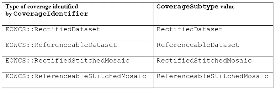
The coverage subtype shall indicate the specific type of the coverage returned, in case of an EO Coverage.
Requirement 37 /req/eowcs/getCapabilities-response-coverageSubtype:
In the response to a successful GetCapabilities request, each EO Coverage listed shall con-tain in its WCS::CoverageSubtype element the value given in Table 8 corresponding to its type.
Table 8 — Values for CoverageSubtype elements of EO Coverages
Type of coverage identified by CoverageIdentifier
CoverageSubtype value
EOWCS::RectifiedDataset RectifiedDataset
EOWCS::ReferenceableDataset ReferenceableDataset
EOWCS::RectifiedStitchedMosaic RectifiedStitchedMosaic
EOWCS::ReferenceableStitchedMosaic ReferenceableStitchedMosaic
Requirement 38 /req/eowcs/getCapabilities-response-countDefault:
ele-19 Copyright © 2014 Open Geospatial Consortium ment in its ows:OperationsMetadata element then its name attribute shall hold a value as defined in Table 9 and the XML Schema being part of this standard.
Table 9 — Values for ows:Constraint elements
Name Definition Data type Multiplicity
CountDefault Default value for the count parameter defined for DescribeEOCoverageSet requests.
Integer greater than or equal to zero
zero or one (optional)
NOTE Servers are strongly encouraged to specify a value for CountDefault as means of self defence, so that a request may not clog the server.
Example The following XML excerpt shows a possible Contents section containing Dataset Series information:
<wcs:Contents>
<wcs:CoverageSummary>
<wcs:CoverageId>someEOCoverage</wcs:CoverageId>
<wcs:CoverageSubtype>RectifiedDataset</wcs:CoverageSubtype>
</wcs:CoverageSummary>
<wcs:Extension>
<wcseo:DatasetSeriesSummary>
<ows:WGS84BoundingBox>
<ows:LowerCorner>-180 -90</ows:LowerCorner> <ows:UpperCorner>180 90</ows:UpperCorner> </ows:WGS84BoundingBox>
<wcseo:DatasetSeriesId>someDatasetSeries</wcseo:DatasetSeriesId> <gml:TimePeriod gml:id="someDatasetSeries_timeperiod">
<gml:beginPosition>2010-01-01T00:00:00.000</gml:beginPosition> <gml:endPosition>2010-12-31T23:59:59.999</gml:endPosition> </gml:TimePeriod>
</wcseo:DatasetSeriesSummary>
</wcs:Extension>
</wcs:Contents>
Example The following XML excerpt shows a possible Constraint section containing a CountDefault value:
<ows:Constraint name="CountDefault">
<ows:NoValues />
<ows:DefaultValue>100</ows:DefaultValue>
</ows:Constraint>
7.3 DescribeCoverage operation
7.3.1 DescribeCoverage request
The DescribeCoverage request is unchanged over WCS Core [OGC 09-110r4]. In particular, identifiers of EO Coverages can be passed as input parameters.
20 Copyright © 2014 Open Geospatial Consortium 7.3.2 DescribeCoverage response
In a DescribeCoverage response, EO Coverage descriptions additionally contain the EO Metadata record.
Requirement 39 /req/eowcs/describeCoverage-response-eo-metadata:
In the response to a successful DescribeCoverage request on an EO Coverage, one
EOWCS::EOMetadata element shall be present containing the EO Metadata component of the coverage addressed.
The coverage subtype shall indicate the specific type of the coverage returned, in case of an EO Coverage.
Requirement 40 /req/eowcs/describeCoverage-response-coverageSubtype:
In the response to a successful DescribeCoverage request addressing an EO Coverage, each EO Coverage listed shall contain in its WCS::CoverageSubtype element the value given in Table 8 corresponding to its type.
Example The following XML fragment shows parts of a possible DescribeCoverage response on an EO Coverage:
<wcs:CoverageDescriptions>
<wcs:CoverageDescription gml:id="c1">
<gml:boundedBy>
<gml:Envelope axisLabels="lat long" srsDimension="2"
srsName="http://www.opengis.net/def/crs/EPSG/0/4326" uomLabels="deg deg"> <gml:lowerCorner>42.862778 1.896944</gml:lowerCorner>
<gml:upperCorner>43.516667 2.861667</gml:upperCorner> </gml:Envelope>
</gml:boundedBy>
<wcs:CoverageId>c1</wcs:CoverageId>
<gmlcov:metadata>
21 Copyright © 2014 Open Geospatial Consortium
</gmlcov:metadata>
<gml:domainSet>
<gml:RectifiedGrid dimension="2" gml:id="c1_grid"> ...
</gml:RectifiedGrid>
</gml:domainSet>
<gmlcov:rangeType>
...
</gmlcov:rangeType>
<wcs:ServiceParameters>
<wcs:CoverageSubtype>RectifiedDataset</wcs:CoverageSubtype> <wcs:nativeFormat>image/tiff</wcs:nativeFormat>
</wcs:ServiceParameters>
</wcs:CoverageDescription>
</wcs:CoverageDescriptions>
NOTE The complete example is provided with the schema files being part of this standard. 7.4 GetCoverage operation
7.4.1 GetCoverage request
The GetCoverage request is unchanged over WCS Core [OGC 09-110r4], except that for EO Coverages slicing is disallowed as it would leave the EO Metadata undefined.
NOTE A GetCoverage request is possible on the identifiers of EO Coverages offered by the server even if these are not listed in a GetCapabilities response.
Requirement 41 /req/eowcs/getCoverage-request-no-slicing:
22 Copyright © 2014 Open Geospatial Consortium 7.4.2 GetCoverage response
The GetCoverage response is as defined in the WCS Core [OGC 09-110r4], however extend-ed in two respects:
The coverage returned contains exactly one metadata element holding the EO Metadata record (it may contain further metadata elements in addition); The lineage component of the EO Metadata record returned consists of the
pre-existing lineage sequence plus one element appended which describes the GetCover-age request on hand.
NOTE As always, whether all these elements will be available to a client depends on the degree of support for the information items by the requested coverage encoding.
On EO Coverages, a GetCoverage request shall produce a coverage of the type correspond-ing to the coverage inspected.
Requirement 42 /req/eowcs/getCoverage-response-coverage-type: The response to a successful GetCoverage request
- on a Rectified Stitched Mosaic shall be of type RectifiedStitchedMosaic, - on a Rectified Dataset shall be of type RectifiedDataset,
- on a Referenceable Stitched Mosaic shall be of type ReferenceableStitchedMosaic, and - on a Referenceable Dataset shall be of type ReferenceableDataset,.
The EO Metadata, including the extended lineage record, shall be delivered alongside with the coverage data, adjusted according to the operations executed during GetCoverage evalua-tion.
Requirement 43 /req/eowcs/getCoverage-response-eo-metadata:
In the response to a successful GetCoverage request on an EO Coverage, the EOWCS::EO-Metadata of the coverage returned shall contain the complete EOWCS::EOMetadata of the coverage addressed, adjusted as specified in Requirement 44, Requirement 45, and Re-quirement 46.
Requirement 44 /req/eowcs/getCoverage-response-eo-metadata-in-stitched-mosaic: In the response to a successful GetCoverage request on a Stitched Mosaic, the EOWCS::EO-Metadata of the coverage returned shall contain the original Stitched Mosaic’s references to those Datasets which have a non-empty intersection with the effective spatio-temporal request trim interval, and no other ones.
Requirement 45 /req/eowcs/getCoverage-response-footprint-in-eo-metadata:
If, in a successful GetCoverage request on an EO Coverage, trimming along spatial coordi-nates is specified then the footprint of the EOWCS::EOMetadata in the coverage returned shall be given by the intersection of the spatial request interval and the footprint of the cover-age requested. Otherwise, the footprint in the result covercover-age shall be given by the footprint of the coverage requested.
23 Copyright © 2014 Open Geospatial Consortium Requirement 46 /req/eowcs/getCoverage-response-lineage-in-eo-metadata:
In the response to a successful GetCoverage request, the Lineage component shall consist of the Lineage component of the coverage requested with one record appended containing the complete, verbatim GetCoverage request leading to this response.
NOTE This content is dependent on the protocol used by the requestor. In case of a GET/KVP request, this will be the request URL with parameters. In case of an XML or SOAP request this will be an XML snippet.
Example The following XML fragment shows parts of a possible GetCoverage response for an EO Cov-erage:
http://schemas.opengis.net/wcs/wcseo/1.0/wcsEOGetCoverage.xsd" gml:id="c1">
<gml:boundedBy>
<gmlcov:Extension>
<wcseo:EOMetadata>
<eop:EarthObservation gml:id="eop_c1"> <om:phenomenonTime>
<gml:TimePeriod gml:id="tp_c1">
<gml:beginPosition>2008-03-13T10:00:06.000</gml:beginPosition> <gml:endPosition>2008-03-13T10:20:26.000</gml:endPosition> </gml:TimePeriod>
</om:phenomenonTime> <om:resultTime>
<gml:TimeInstant gml:id="archivingdate_c1">
24 Copyright © 2014 Open Geospatial Consortium
<gml:timePosition>2011-02-04T15:45:52Z</gml:timePosition> </wcseo:lineage>
xsi:schemaLocation="http://www.opengis.net/wcs/2.0
http://schemas.opengis.net/wcs/2.0/wcsAll.xsd" service="WCS" version="2.0.1"> <wcs:CoverageId>c1</wcs:CoverageId>
<gml:timePosition>2011-02-04T15:45:52Z</gml:timePosition> </wcseo:lineage>
</wcseo:EOMetadata>
</gmlcov:Extension>
</gmlcov:metadata>
</wcseo:RectifiedDataset>
7.5 DescribeEOCoverageSet operation
7.5.1 Overview
25 Copyright © 2014 Open Geospatial Consortium 7.5.2 DescribeEOCoverageSet request
Requirement 47 /req/eowcs/describeEOCoverageSet-request-structure:
A DescribeEOCoverageSet request shall consist of a structure as defined in Figure 8, Table 10 and the XML schema being part of this standard.
The DescribeEOCoverageSet request type contains two sections (cf. [OGC 06-121r9] Clause 7.3.3) whose appearance in the response can be controlled by the client through the optional
sections parameter.
Requirement 48 /req/eowcs/describeEOCoverageSet-request-sections:
If a DescribeEOCoverageSet request contains an ows:Sections element then this element shall contain one of the values “CoverageDescriptions”, “DatasetSeriesDescriptions”, or “All”.
Dependency: [OGC 06-121r9] clause 7.3.3
NOTE This use of the sections parameters issimilar to its use in GetCapabilities as defined in OWS Common [OGC 06-121r9].
NOTE Future versions of the EO-WCS are likely to use the DimensionTrim element defined in the forthcoming Predefined CRSs Extension instead of WCS::DimensionTrim.
Requirement 49 /req/eowcs/describeEOCoverageSet-request-eoId:
Each eoId parameter value in a DescribeEOCoverageSet request shall be equal to the iden-tifier of a Dataset, a Stitched Mosaic, or a Dataset Series offered by the server addressed. NOTE A DescribeEOCoverageSet request is possible on the identifiers of objects offered by the server even if these are not listed in a GetCapabilities response.
Requirement 50 /req/eowcs/describeEOCoverageSet-request-containment:
If a DescribeEOCoverageSet request contains a containment parameter then this parame-ter shall have one of the values “contains” or “overlaps”.
Requirement 51 /req/eowcs/describeEOCoverageSet-request-dimensions:
If a DescribeEOCoverageSet request contains dimensionTrim elements with dimen-sion parameters then each such dimension parameter shall have one of the values “lat”, “long”, or “phenomenonTime”, Each of these values shall appear at most once in a given request.
Requirement 52 /req/eowcs/describeEOCoverageSet-request-crs:
A DescribeEOCoverageSet request shall use WGS84 [4] as spatial and ISO 8601 [2] as tem-poral CRS for the coordinates in trim requests.
26 Copyright © 2014 Open Geospatial Consortium Figure 8 — DescribeEOCoverageSet request UML diagram
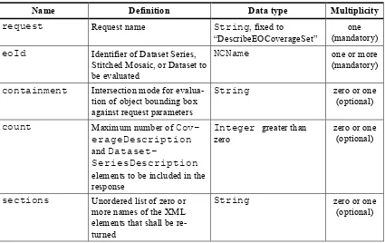
Table 10 — Components of DescribeEOCoverageSet operation request
Name Definition Data type Multiplicity
request Request name String, fixed to “DescribeEOCoverageSet”
one (mandatory)
eoId Identifier of Dataset Series, Stitched Mosaic, or Dataset to be evaluated
NCName one or more
(mandatory)
containment Intersection mode for evalua-tion of object bounding box against request parameters
String zero or one
(optional)
count Maximum number of Cov-erageDescription and
Dataset-SeriesDescription elements to be included in the response
Integer greater than zero
zero or one (optional)
sections Unordered list of zero or more names of the XML elements that shall be re-turned
String zero or one
27 Copyright © 2014 Open Geospatial Consortium
dimensionTrim trim specification, as per WCS Core [OGC 09-110r4] Subclause 8.4.1
WCS::DimensionTrim zero or more (optional)
Example The following XML instance shows a possible DescribeEOCoverageSet operation request:
<wcseo:DescribeEOCoverageSet xmlns:wcseo="http://www.opengis.net/wcs/wcseo/1.0"
xmlns:wcs="http://www.opengis.net/wcs/2.0"
xmlns:xsi="http://www.w3.org/2001/XMLSchema-instance"
xsi:schemaLocation="http://www.opengis.net/wcs/wcseo/1.0
http://schemas.opengis.net/wcs/wcseo/1.0/wcsEOAll.xsd" service="WCS" ver-sion="2.0.1" count="100">
<wcseo:eoId>DS1</wcseo:eoId>
<wcseo:containment>overlaps</wcseo:containment>
<wcseo:sections>
<wcseo:section>All</wcseo:section>
</wcseo:sections>
<wcs:DimensionTrim>
<wcs:Dimension>long</wcs:Dimension>
<wcs:TrimLow>16</wcs:TrimLow>
<wcs:TrimHigh>18</wcs:TrimHigh>
</wcs:DimensionTrim>
<wcs:DimensionTrim>
<wcs:Dimension>lat</wcs:Dimension>
<wcs:TrimLow>40</wcs:TrimLow>
<wcs:TrimHigh>42</wcs:TrimHigh>
</wcs:DimensionTrim>
<wcs:DimensionTrim>
<wcs:Dimension>phenomenonTime</wcs:Dimension>
<wcs:TrimLow>2008-03-13T10:10:00Z</wcs:TrimLow>
<wcs:TrimHigh>2008-03-13T10:11:00Z</wcs:TrimHigh>
</wcs:DimensionTrim>
</wcseo:DescribeEOCoverageSet>
7.5.3 DescribeEOCoverageSet response
The response to a successful DescribeEOCoverageSet request consists of a (possibly empty) set of EO Coverage descriptions and a (possibly empty) set of Dataset Series descriptions (cf. Figure 9).
Requirement 53 /req/eowcs/describeEOCoverageSet-response-structure: The response to a successful DescribeEOCoverageSet request shall consist of a
EOWCS::EOCoverageSetDescription structure as defined in Table 11, Figure 9 and the XML Schema being part of this standard.
Dependency: [OGC 09-110r4] Subclause 8.3.2 (http://www.opengis.net/doc/IS/WCS/2.0/clause/8)
Table 11 — Components of EOCoverageSetDescription structure
Name Definition Data type Multiplicity
datasetSeries-Descriptions
Unordered sequence of Dataset Series descriptions
Unordered sequence of coverage descriptions
WCS::Coverage-Descriptions
28 Copyright © 2014 Open Geospatial Consortium Figure 9 — DescribeEOCoverageSet response UML diagram
Requirement 54 /req/eowcs/describeEOCoverageSet-response-eo-metadata: Each WCS::CoverageDescription listed in the response to a successful
De-scribeEOCoverageSet request shall contain one EOWCS::EOMetadata element containing the EO Metadata component of the EO Coverage to be described.
The response shall respect the sections request parameter.
Requirement 55 /req/eowcs/describeEOCoverageSet-response-section-coverageDescriptions:
If a DescribeEOCoverageSet request contains a sections parameter then a successful re-sponse shall contain a wcs:CoverageDescriptions element if and only if the section parameter list contains one of the values “CoverageDescriptions” or “All”.
Requirement 56 /req/eowcs/describeEOCoverageSet-response-section-datasetSeriesDescriptions:
If a DescribeEOCoverageSet request contains a sections parameter then a successful re-sponse shall contain a eowcs:DatasetSeriesDescriptions element if and only if the section parameter list contains one of the values “DatasetSeriesDescriptions” or “All”.
Such a response contains only EO Coverages directly referred to by the object(s) addressed in the request or via referred Dataset Series.
Requirement 57 /req/eowcs/describeEOCoverageSet-response-eoId:
In the response to a successful DescribeEOCoverageSet request containing a wcs:Cover-ageDescription section, each EO Coverage referred to by one of the objects identified in the eoId request parameter shall appear at most once.
Requirement 58 /req/eowcs/describeEOCoverageSet-response-referred:
wcs:Cover-29 Copyright © 2014 Open Geospatial Consortium
ageDescription section shall contain the descriptions of exactly those EO Coverages referred to directly or indirectly via Dataset Series by one of the objects identified in the
eoId request parameter, without any duplicates.
NOTE A Dataset referred to by a Dataset Series referred to by another Dataset Series is implicitly re-ferred to by the later Dataset Series and thus always reported by a DescribeEOCoverageSet request against the later Dataset Series. However, it is allowed that such a Dataset is also referred to by the first Dataset Series but it is only reported once.
NOTE A Dataset referred to by a Stitched Mosaic referred to by a Dataset Series is not per se referred to by that Dataset Series and thus not reported by a DescribeEOCoverageSet request against the Dataset Se-ries. However, it is allowed that such a Dataset is also referred to by the enclosing Dataset SeSe-ries. Spatial subsetting is evaluated against the eop:Footprint element contained in the
EOMetadata element of an EO Coverage.
Requirement 59 /req/eowcs/describeEOCoverageSet-response-containment:
The response to a successful DescribeEOCoverageSet request containing a wcs:Cover-ageDescription section shall contain only descriptions of those EO Coverages whose spatial footprint defined by its eop:EarthObservation/om:featureOfInter-est/eop:Footprint
- overlaps with the spatial request extent, and the request parameter containment is of value overlaps or is omitted,
- is completely contained within the spatial request extent, and the request parameter con-tainment is of value contains
whereby all spatial coordinates are expressed in WGS84 [2].
Temporal subsetting is evaluated against the temporal validity of an EO Coverage. Requirement 60 /req/eowcs/describeEOCoverageSet-response-phenomenonTime: The response to a successful DescribeEOCoverageSet request containing a wcs:Cover-ageDescription section shall contain only descriptions of EO Coverages whose time interval defined by its
eop:EarthObservation/om:phenomenon-Time/gml:TimePeriod/gml:beginPosition and eop:EarthObservation/-om:phenomenonTime/gml:TimePeriod/gml:endPosition elements in
eowcs:EOMetadata
- overlaps with the request time extent,and the request parameter containment is of value
overlaps or is omitted,
- is completely contained within the request time extent, and the request parameter con-tainment is of value contains,
whereby all temporal coordinates are expressed in ISO 8601 [2].
Boundary values omitted are substituted by the actual boundary value of the object inquired. Requirement 61 /req/eowcs/describeEOCoverageSet-response-trim-omitted:
30 Copyright © 2014 Open Geospatial Consortium Requirement 62 /req/eowcs/describeEOCoverageSet-response-bound-omitted:
In a DescribeEOCoverageSet request, a lower or upper bound omitted shall be interpreted as indicating the actual lower or upper bound of the objects requested in the axis omitted. NOTE This trim semantics is analogous to trimming in GetCoverage.
Requirement 63 /req/eowcs/describeEOCoverageSet-response-coverageSubtype: In the response to a successful DescribeEOCoverageSet request, each EO Coverage listed shall contain in its WCS::CoverageSubtype element the corresponding value given in Table 8 according to its type.
Requirement 64 /req/eowcs/describeEOCoverageSet-response-count:
In the response to a successful DescribeEOCoverageSet request the sum of CoverageDe-scription and DatasetSeriesDescription elements shall be less or equal to the minimum of the value of the CountDefault element and the count parameter if present in the request. If none of both are present all matching elements shall be reported.
Requirement 65 /req/eowcs/describeEOCoverageSet-response-numberMatched: The response to a successful DescribeEOCoverageSet request shall report in its number-Matched attribute the sum of all matching CoverageDescription and Dataset-SeriesDescription elements.
Requirement 66 /req/eowcs/describeEOCoverageSet-response-numberReturned: The response to a successful DescribeEOCoverageSet request shall report in its number-Returned attribute the sum of all CoverageDescription and DatasetSeriesDe-scription elements included in the response.
Example The following XML fragment shows parts of a possible DescribeEOCoverageSet operation response:
<wcseo:EOCoverageSetDescription numberMatched="2" numberReturned="2">
<wcs:CoverageDescriptions>
<wcs:CoverageDescription gml:id="c1">
<gml:boundedBy> ...
</gml:boundedBy>
<wcs:CoverageId>c1</wcs:CoverageId> <gmlcov:metadata> <wcs:ServiceParameters>
<wcs:CoverageSubtype>RectifiedStitchedMosaic</wcs:CoverageSubtype> <wcseo:dataset>
31 Copyright © 2014 Open Geospatial Consortium </wcseo:dataset>
</wcs:ServiceParameters>
</wcs:CoverageDescription>
</wcs:CoverageDescriptions>
<wcseo:DatasetSeriesDescriptions>
<wcseo:DatasetSeriesDescription gml:id="ds2">
<gml:boundedBy>
<gml:Envelope axisLabels="lat long" srsDimension="2"
srsName="http://www.opengis.net/def/crs/EPSG/0/4326" uomLabels="deg deg"> <gml:lowerCorner>46 16</gml:lowerCorner>
<gml:upperCorner>48 18</gml:upperCorner> </gml:Envelope>
</gml:boundedBy>
<wcseo:DatasetSeriesId>ds2</wcseo:DatasetSeriesId> <gml:TimePeriod gml:id="ds2_timeperiod">
<gml:beginPosition>2010-01-01T00:00:00.000</gml:beginPosition> <gml:endPosition>2010-12-31T23:59:59.999</gml:endPosition> </gml:TimePeriod>
</wcseo:DatasetSeriesDescription>
</wcseo:DatasetSeriesDescriptions>
</wcseo:EOCoverageSetDescription>
7.5.4 DescribeEOCoverageSet exceptions
Table 12 — Exception codes for DescribeEOCoverageSet operation
exceptionCode value HTTP code
Meaning of exception code locator value
NoSuch- DatasetSeries-OrCoverage
404 The identifier passed does not match with any of the Dataset Series or EO Coverage offered by this server
List of violating Data-set Series and/or EO Coverage identifiers
8 WCS extensions
8.1 Overview
Requirements class eowcs normatively depends on the WCS Extension specifications listed in this Clause. In other words, any implementation claiming to conform to this requirements class must also implement the specifications required in this Clause.
8.2 Band subsetting
Requirement 67 /req/eowcs/band-subsetting:
Implementations of this EO-WCS shall support the WCS 2.0 Range Subsetting Extension [OGC 12-040].
Dependency: http://www.opengis.net/spec/WCS_service-extension_range-subsetting/1.0/conf/record-subsetting
8.3 Scaling & interpolation
Requirement 68 /req/eowcs/scaling:
12-32 Copyright © 2014 Open Geospatial Consortium 039].
Dependency: http://www.opengis.net/spec/WCS_service-extension_scaling/1.0/conf/scaling Requirement 69 /req/eowcs/interpolation:
Implementations of this EO-WCS shall support the WCS 2.0 Interpolation Extension [OGC 12-049].
Dependency: http://www.opengis.net/spec/WCS_service-extension_interpolation/1.0/conf/interpolation
8.4 CRSs
Requirement 70 /req/eowcs/crs:
Implementations of this EO-WCS shall support the WCS 2.0 CRS Extension [OGC 11-053]. Dependency: http://www.opengis.net/spec/WCS_service-extension_crs/1.0/conf/crs
8.5 Coverage format encodings
Requirement 71 /req/eowcs/encodings:
Implementations of this EO-WCS shall support at least one of the WCS 2.0 coverage format encodings GeoTIFF [OGC12-100r1], NetCDF [OGC 11-010], and JPEG2000 [OGC 11-011]. Dependency: http://www.opengis.net/spec/GMLCOV_geotiff-coverages/1.0/conf/geotiff-coverage, http://www.opengis.net/spec/WCS_encoding_netcdf/1.0/conf/netcdf,
http://www.opengis.net/spec/WCS_encoding_jpeg2000/1.0/conf/jpeg2000 9 Protocol Bindings
9.1 Protocol choices
At least one of the protocols, GET/KVP and SOAP shall be supported by an implementation. This choice is represented in this specification by two separate conformance classes,
eowcs_get-kvp and eowcs_soap defined in the Subclauses below.
Requirement 72 /req/eowcs/protocol-bindings:
Implementations of this EO-WCS shall support at least one of the requirements classes eowcs_get-kvp and eowcs_soap.
Dependency:
http://www.opengis.net/spec/WCS_application-profile_earth-observation/1.0/conf/eowcs_get-kvp, http://www.opengis.net/spec/WCS_application-profile_earth-observation/1.0/conf/eowcs_soap
9.2 GET-KVP protocol conformance class
9.2.1 WCS GET/KVP encoding
Requirement 73 /req/eowcs_get-kvp/mandatory:
Implementations of this EO-WCS which support the eowcs_get-kvp requirements class shall support the WCS 2.0 protocol extension GET/KVP [OGC 09-147r3].
Dependency: http://www.opengis.net/spec/WCS_protocol-binding_get-kvp/1.0/conf/get-kvp Requirement 74 /req/eowcs_get-kvp/conformance-class-in-profile: