Publication Date: 2014-02-26 Approval Date: 2013-12-13 Submission Date: 2013-06-21 Reference number of this Document: OGC 12-040 Reference URL for this document:
http://www.opengis.net/doc/IS/WCS-service-extension-range-subsetting/1.0
Version: 1.0 Category: OGC® Interface Standard Editor: Peter Baumann, Jinsongdi Yu
OGC® Web Coverage Service Interface Standard -
Range Subsetting Extension
Copyright © 2014 Open Geospatial Consortium
To obtain additional rights of use, visit http://www.opengeospatial.org/legal/.
Warning
This document is an OGC Member approved international standard. This document is availa-ble on a royalty free, non-discriminatory basis. Recipients of this document are invited to submit, with their comments, notification of any relevant patent rights of which they are aware and to provide supporting documentation.
ii Copyright © 2014 Open Geospatial Consortium Permission is hereby granted by the Open Geospatial Consortium, ("Licensor"), free of charge and subject to the terms set forth below, to any person obtaining a copy of this Intellectual Property and any associated documentation, to deal in the Intellectual Property without restriction (except as set forth below), including without limitation the rights to implement, use, copy, modify, merge, publish, distribute, and/or sublicense copies of the Intellectual Property, and to permit persons to whom the Intellectual Property is furnished to do so, provided that all copyright notices on the intellectual property are retained intact and that each person to whom the Intellectual Property is furnished agrees to the terms of this Agreement.
If you modify the Intellectual Property, all copies of the modified Intellectual Property must include, in addition to the above copy-right notice, a notice that the Intellectual Property includes modifications that have not been approved or adopted by LICENSOR.
THIS LICENSE IS A COPYRIGHT LICENSE ONLY, AND DOES NOT CONVEY ANY RIGHTS UNDER ANY PATENTS THAT MAY BE IN FORCE ANYWHERE IN THE WORLD.
THE INTELLECTUAL PROPERTY IS PROVIDED "AS IS", WITHOUT WARRANTY OF ANY KIND, EXPRESS OR IMPLIED, INCLUDING BUT NOT LIMITED TO THE WARRANTIES OF MERCHANTABILITY, FITNESS FOR A PARTICULAR PURPOSE, AND NONINFRINGEMENT OF THIRD PARTY RIGHTS. THE COPYRIGHT HOLDER OR HOLDERS INCLUDED IN THIS NOTICE DO NOT WARRANT THAT THE FUNCTIONS CONTAINED IN THE INTELLECTUAL PROPERTY WILL MEET YOUR REQUIREMENTS OR THAT THE OPERATION OF THE INTELLECTUAL PROPERTY WILL BE
UNINTERRUPTED OR ERROR FREE. ANY USE OF THE INTELLECTUAL PROPERTY SHALL BE MADE ENTIRELY AT THE USER’S OWN RISK. IN NO EVENT SHALL THE COPYRIGHT HOLDER OR ANY CONTRIBUTOR OF
INTELLECTUAL PROPERTY RIGHTS TO THE INTELLECTUAL PROPERTY BE LIABLE FOR ANY CLAIM, OR ANY DIRECT, SPECIAL, INDIRECT OR CONSEQUENTIAL DAMAGES, OR ANY DAMAGES WHATSOEVER RESULTING FROM ANY ALLEGED INFRINGEMENT OR ANY LOSS OF USE, DATA OR PROFITS, WHETHER IN AN ACTION OF CONTRACT, NEGLIGENCE OR UNDER ANY OTHER LEGAL THEORY, ARISING OUT OF OR IN CONNECTION WITH THE IMPLEMENTATION, USE, COMMERCIALIZATION OR PERFORMANCE OF THIS INTELLECTUAL PROPERTY.
This license is effective until terminated. You may terminate it at any time by destroying the Intellectual Property together with all copies in any form. The license will also terminate if you fail to comply with any term or condition of this Agreement. Except as provided in the following sentence, no such termination of this license shall require the termination of any third party end-user subli-cense to the Intellectual Property which is in force as of the date of notice of such termination. In addition, should the Intellectual Property, or the operation of the Intellectual Property, infringe, or in LICENSOR’s sole opinion be likely to infringe, any patent, copyright, trademark or other right of a third party, you agree that LICENSOR, in its sole discretion, may terminate this license with-out any compensation or liability to you, your licensees or any other party. You agree upon termination of any kind to destroy or cause to be destroyed the Intellectual Property together with all copies in any form, whether held by you or by any third party.
iii Copyright © 2014 Open Geospatial Consortium
Contents
Page
1
Scope ... 1
2
Conformance ... 1
3
Normative references ... 1
4
Terms and definitions ... 2
5
Conventions ... 2
5.1
UML notation ... 2
5.2
Data dictionary tables ... 2
5.3
Namespace prefix conventions ... 3
5.4
Multiple representations ... 3
6
record-subsetting
requirements class ... 3
6.1
Overview ... 3
6.2
Modifications to
GetCapabilities
... 3
6.3
Modifications to
DescribeCoverage
... 4
6.4
Modifications to
GetCoverage
... 4
Annex A (normative) Abstract test suite ... 11
A.1
Conformance Test Class:
record-subsetting
... 11
A.1.1
Record-subsetting extension identifier ... 11
A.1.2
GetCoverage request syntax ... 11
A.1.3
GetCoverage subsetting list ... 12
A.1.4
GetCoverage existing component ... 12
A.1.5
GetCoverage subsetting expansion ... 12
A.1.6
GetCoverage interval order ... 13
A.1.7
GetCoverage response ... 13
A.1.8
GetCoverage response component ... 13
A.1.9
GetCoverage response content ... 14
A.1.10
KVP request list encoding ... 14
A.1.11
KVP request component encoding ... 14
A.1.12
KVP request interval encoding ... 15
A.1.13
XML/Post request encoding ... 15
iv Copyright © 2014 Open Geospatial Consortium
Tables
PageTable 1 — Conformance class dependencies ... 2
Table 2 — Namespace mappings ... 3
Table 3 — Components of RSub::GetCoverageWithRangeSubset structure ... 5
v Copyright © 2014 Open Geospatial Consortium
i.
Abstract
This document specifies parameters to the OGC Web Coverage Service (WCS) GetCoverage request which allow extraction of specific fields, according to the range type specification, from the range set of a coverage during server-side processing of a coverage in a GetCover-age request.
Suggested additions, changes, and comments on this draft document are welcome and en-couraged. Such suggestions may be submitted by email message or by making suggested changes in an edited copy of this document.
ii.
Keywords
ogcdoc, wcs, Big Data, range_subsetting, extension, band extraction, channel extraction
iii.
Terms and definitions
This document uses the standard terms defined in Subclause 5.3 of [OGC 06-121r9], which is based on the ISO/IEC Directives, Part 2, Rules for the structure and drafting of International Standards. In particular, the word “shall” (not “must”) is the verb form used to indicate a requirement to be strictly followed to conform to this standard.
iv.
Submitting organizations
The following organizations have submitted this Interface Specification to the Open Geospa-tial Consortium, Inc.:
Jacobs University Bremen Fuzhou University
v.
Document Contributor Contact Points
vi.
Revision history
Date Release Author Paragraph modified Description
2012-04-20 0.0.1 Peter Baumann All Created
2013-01-17 0.0.2 Peter Baumann 6+; Annex A Conformance classes for the proto-col bindings
2013-12-17 1.0.0 Peter Baumann Several Editorial finalization
Name Organization
Peter Baumann Jacobs University Bremen, rasdaman GmbH
vi Copyright © 2014 Open Geospatial Consortium
vii.
Changes to the OGC
®Abstract Specification
The OGC® Abstract Specification does not require any changes to accommodate the technical contents of this (part of this) document.
viii.
Future Work
Among the topics for future development are the following items:
Establish a conformance class for subsetting of array-valued range types, i.e., fields whose definition in the coverage range type is described by a <swe:DataArray>.
Establish a conformance class for subsetting of nested range types, i.e., fields whose definition in the coverage range type is described by a an arbitrary nesting of
vii Copyright © 2014 Open Geospatial Consortium
Foreword
This WCS Range Subsetting extension is an OGC Interface Standard which relies on WCS Core [OGC 09-110r4] and the GML Application Schema for Coverages [OGC 09-146r2]. This document includes one normative Annex.
Attention is drawn to the possibility that some of the elements of this document may be the subject of patent rights. The Open Geospatial Consortium shall not be held responsible for identifying any or all such patent rights.
viii Copyright © 2014 Open Geospatial Consortium
Introduction
The OGC Web Coverage Service (WCS) – Range Subsetting Extension defines an extension to the WCS Core [OGC 09-110r4] to request and obtain a coverage with the original domain set but a reduced (extracted) range set as compared to the coverage addressed.
Selection is based on the coverage’s range type definition where identifiable components are given; in some domains these range components defined in the range type are referred to as “channels”, “bands”, or “variables”. Various methods are provided for specifying the range components to be retained in the result, such as individual components, lists of components, intervals (based on the range type order), and combinations thereof.
1 Copyright © 2014 Open Geospatial Consortium.
OGC® Web Coverage Service Interface Standard - Range
Subsetting Extension
1 Scope
This OGC WCS Range Subsetting Extension defines retrieval of selected range components from coverages offered by a WCS server. According to the GML 3.2.1 Application Schema – Coverages [OGC 09-146r2], all range cells (commonly called “pixel” or “voxel” in various application domains) of a coverage share a common type, the range type. This range type is built on the DataRecord and DataArray type construction mechanisms established in SWE Common [OGC 08-094r1]; in other words, a range cell can be a record, or an array, or a nest-ing of these constructors.
This OGC WCS Range Subsetting Extension establishes how a client can request an extract from such composite range elements from a WCS server. The core conformance class of this standard, record-subsetting, defines extraction from unnested records (such as hyperspectral satellite imagery). In a future revision of this standard, optional conformance class array-subsetting will define such extraction from nested arrays, and optional conformance class nested-subsetting, will define access to nested record and array range types.
2 Conformance
This document establishes the following requirements and conformance classes:
record-subsetting, of URI
http://www.opengis.net/spec/WCS_service-extension_range-subsetting/1.0/req/record-subsetting; the corresponding conformance class is record-subsetting, with URI http://www.opengis.net/spec/WCS_service-extension_range-subsetting/1.0/conf/record-subsetting.
This is the mandatory core conformance class for this extension.
Standardisation target of all requirements and conformance classes are WCS implementations (currently: servers).
Requirements URIs defined in this document are relative to
http://www.opengis.net/spec/WCS_service-extension_range-subsetting/1.0/req, conformance test URIs are relative to http://www.opengis.net/spec/WCS_service-extension_range-subsetting/1.0/conf.
Annex A lists the conformance tests which shall be exercised on any software artefact claim-ing to implement WCS.
3 Normative references
2 Copyright © 2014 Open Geospatial Consortium http://www.opengis.net/spec/WCS_service-extension_range-subsetting/1.0, the document has OGC URI http://www.opengis.net/doc/IS/WCS_service-extension_range-subsetting/1.0. The standard is available for download from http://www.opengeospatial.org/standards/wcs; additionally, the XML Schema is posted online at http://schemas.opengis.net/wcs/range-subsetting/1.0 as part of the OGC schema repository. In the event of a discrepancy between bundled and schema repository versions of the XML Schema files, the schema repository shall be considered authoritative.
The normative documents listed in Table 1 contain provisions that, through reference in this text, constitute provisions of this specification. For dated references, subsequent amendments to, or revisions of, any of these publications do not apply. For undated references, the latest edition of the normative document referred to applies.
Table 1 — Conformance class dependencies Range subsetting
conformance class
Dependency document Dependency
con-formance class record-subsetting OGC 09-146, GML 3.2.1 Application Schema for
Coverages, version 1.0
OGC 09-110, OGC® Web Coverage Service 2.0 Interface Standard - Core, version 2.0
gml-coverage
core
4 Terms and definitions
For the purposes of this document, the terms and definitions given in the above references apply. In addition, the following terms and definitions apply. An arrow ““ indicates that the following term is defined in this Clause.
- None defined here -
5 Conventions
5.1 UML notation
Unified Modeling Language (UML) static structure diagrams appearing in this specification are used as described in Subclause 5.2 of OGC Web Services Common [OGC 06-121r9]. 5.2 Data dictionary tables
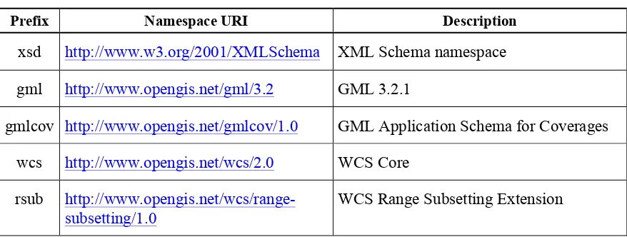
3 Copyright © 2014 Open Geospatial Consortium. 5.3 Namespace prefix conventions
The following namespaces are used in this document. The prefix abbreviations used consti-tute conventions used here, but are not normative. The namespaces to which the prefixes refer are normative, however.
Table 2 — Namespace mappings
Prefix Namespace URI Description
xsd http://www.w3.org/2001/XMLSchema XML Schema namespace gml http://www.opengis.net/gml/3.2 GML 3.2.1
gmlcov http://www.opengis.net/gmlcov/1.0 GML Application Schema for Coverages wcs http://www.opengis.net/wcs/2.0 WCS Core
rsub http://www.opengis.net/wcs/range-subsetting/1.0
WCS Range Subsetting Extension
5.4 Multiple representations
When multiple representations of the same information are given in a specification document these are consistent. Should this not be the case then this is considered an error, and the XML schema shall take precedence.
6 record-subsetting requirements class 6.1 Overview
This Clause 6 establishes the mandatory WCS Range Subsetting Extension core conformance class, record-subsetting.This conformance class specifies how to request and obtain coverag-es where multiple range field components are extracted from a record-valued range field, i.e., a range field whose definition in the coverage range type is described by a
<swe:DataRecord>.
Note This is the core requirements class because the range type of a coverage, as per GMLCOV [09-146r2], always is a <swe:DataRecord>.
The records are flat, i.e., no nesting of record components is addressed here. 6.2 Modifications to GetCapabilities
A server announces support of the Range Subsetting Extension to a client by adding the URL identifying this extension to the list of supported extensions delivered in the Capabilities document.
Requirement 1 extension-identifier:
ServiceI-4 Copyright © 2014 Open Geospatial Consortium dentification in any GetCapabilities response:
http://www.opengis.net/spec/WCS_service-extension_range-subsetting/1.0/conf/record-subsetting
6.3 Modifications to DescribeCoverage None.
6.4 Modifications to GetCoverage 6.4.1 GetCoverage request
A range subsetting request parameter consists of a sequence of range component selections. Such a selection item can either be a range component name as defined in the range type of the coverage queries, or a range interval specifying a sequence consisting of all range com-ponents between the first (start) element of the interval and the last (end) element of the in-terval, including start and end.
Requirement 2 getCoverage-request-syntax:
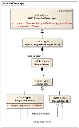
5 Copyright © 2014 Open Geospatial Consortium. Figure 1 — GetCoverage with range subsetting support UML diagram
Table 3 — Components of RSub::GetCoverageWithRangeSubset structure
Name Definition Data type Multiplicity
RangeItem List of range components to be extracted
RangeComponent or RangeInterval
one or more (mandatory) RangeComponent Range component name RangeComponent one
(mandatory) RangeInterval Pair of range interval
lower and upper bound
Pair of RangeCom-ponent
one (mandatory)
Requirement 3 getCoverage-subsetting-list:
6 Copyright © 2014 Open Geospatial Consortium value a non-empty RSub::RangeItem list as specified in Table 2, whereby each
RSub::RangeItem is either a RSub::RangeComponent or a RSub::RangeInter-val.
Note this implies that a mixing of rangeComponent and rangeInterval is possible – see example following Requirement 12.
The range subsetting parameter may only refer to existing range type components of the tar-get coverage.
Requirement 4 getCoverage-existing-component:
In the RSub::RangeSubset parameter of a GetCoverage request, for each
RSub::RangeComponent there shall exist a corresponding component name in the range type of the coverage addressed.
Note Duplicate range components are allowed; for example, a single component can be tripled into an RGB representation of that (grayscale) “channel”. In GET/KVP syntax (cf. Subclause 0) transforming the red channel into RGB can be written as follows:
…& RANGESUBSET=red,red,red &…
Interval addressing is a short-hand for enumerating a sequence of components in the order they appear in the original coverage’s range type.
Requirement 5 getCoverage-subsetting-expansion:
In the RangeSubset parameter of a GetCoverage request, if present, an RSub::Range-Interval with RSub::startComponent a and RSub::endComponent b shall be
equivalent to a sequence of r1, …, rn where r1=a and rn=b and each ri is a range
compo-nent name in the original coverage’s range type and the sequence is sorted in document order of the original coverage’s range type.
Example Assume that the original coverage has a range type definition consisting of the component se-quence (band1, band2, band3, band4, band5). Then, a RangeSubset selection of band2:band4
is equivalent to a selection of band2,band3,band4.
Requirement 6 getCoverage-subsetting-interval-order:
In a RSub::RangeInterval with RSub::startComponent a and RSub::end-Component b contained in the RangeSubset parameter of a GetCoverage request, range
component ashall be before b or equal to b (in document order) in the range component
sequence of the RangeType of the coverage addressed.
Note This requirement forbids range intervals where the lower bound of the interval is higher than the upper bound, in terms of the range type definition.
Example Using the previous RGB example, the following is disallowed and will lead to an exception: blue:red
6.4.2 GetCoverage response
7 Copyright © 2014 Open Geospatial Consortium. Requirement 7 getCoverage-response-no-subsetting:
The response to a successful GetCoverage request containing no RSub::RangeSubset parameter shall consist of a coverage whose range type contains exactly the original cover-age’s range type elements in the proper sequence of this list.
Requirement 8 getCoverage-response-components:
The response to a successful GetCoverage request containing a RSub::RangeSubset pa-rameter consisting of list r1, …, rn of range component names, for some n>0, shall consist of
a coverage whose range type contains exactly the original coverage’s range type elements identified by r
1, …, rn, in the proper sequence of this list.
Example Assume that the original coverage has a range type definition consisting of the component se-quence (band1, band2, band3, band4, band5). Then, a RangeSubset selection of band1,band5,band3
will result in a coverage with range type sequence (band1,band5,band3).
Requirement 9 getCoverage-response-contents:
The response to a successful GetCoverage request containing a RSub::RangeSubset pa-rameter consisting of list r1, …, rn of range component names, for some n>0, shall consist of
a coverage whose range set contains, for each domain coordinate of the coverage returned, exactly those components of the original coverage’s range set values which are identified by
r1, …, rn, in the proper sequence of this list.
Example Assume that the original coverage has a range type definition consisting of the component se-quence (band1, band2, band3, band4, band5) and a single range value (1,2,3,4,5). Then, a RangeSubset selection of band1,band5,band3 will result in a coverage containing the range value (1,5,3).
6.5 Parameter Encoding 6.5.1 Overview
This Clause establishes conformance classes specifying how requests containing range sub-setting operations shall be encoded, depending on the protocol binding used by the request. 6.5.2 GET/KVP Encoding
Requirement 10 request-encoding-kvp-list:
In a GetCoverage request encoded in GET/KVP, the encoding of a RangeSubset parameter consisting of list r1, …, rn of RSub::RangeItems, for some n>1, shall consist of an
or-dered, comma-separated list of the ri in their proper order.
Requirement 11 request-encoding-kvp-component:
In a GetCoverage request encoded in GET/KVP, the encoding of an RSub::rangeComp-onent in a RSub::RangeSubset parameter shall consist of this component name. Requirement 12 request-encoding-kvp-interval:
8 Copyright © 2014 Open Geospatial Consortium Example 1 The following KVP request snippet extracts the component named “red” from the coverage
addressed (assuming that these components are defined in the coverage’s range type): …& RANGESUBSET=red &…
Example 2 The following KVP request snippet extracts the three components named “nir”, “red”, and “green” from the coverage addressed (assuming that these components are defined in the cov-erage’s range type):
…& RANGESUBSET=nir,red,green &…
Example 3 The following KVP request snippet extracts the three components named “red”, “green”, and “blue” from the coverage addressed (assuming that these components are defined in the cover-age’s range type), but changes its sequence over the original coverage range type definition: …& RANGESUBSET=green,red,blue &…
Example 4 The following KVP request snippet extracts a number of components from the coverage adress-ed, starting from component “nir” up to component “green”.Assuming that the coverage’s range typecontains, in contiguous XML document order, “nir”, “red”, and “green”, the resulting coverage will contain these three range components “nir”, “red”, and “green”:
…& RANGESUBSET=nir:green &…
Example 5 The following KVP request snippet shows mixing of the previously exemplified component selection; for a range type consisting of band01 to band36 (with the obvious order of bands), the request results in a record containing the components band01, band03, band04, band05, band19,band20,band21:
…& RANGESUBSET=band01,band03:band05,band19:band21 &…
6.5.3 POST/XML Encoding
Requirement 13 request-encoding-xml:
In a GetCoverage request encoded in XML/POST, the encoding of an RSub::rangeSub-set shall consist of a structure as defined in the XML schema accompanying this standard. Example The following XML rsub:rangeSubset selects band1, band3, band4, and band5 from a
coverage whose range type contains bands1 through band5:
<wcs:GetCoverage xmlns:wcs=http://www.opengis.net/wcs/2.0 xmlns:gml=http://www.opengis.net/gml/3.2
xmlns:xsi=http://www.w3.org/2001/XMLSchema-instance
xmlns:crs=http://www.opengis.net/wcs_service-extension_crs/1.0
service="WCS" version="2.0.1"> <wcs:Extension>
<rsub:RangeSubset> <rsub:RangeItem>
<rsub:RangeComponent>band1</rsub:RangeComponent> </rsub:RangeItem>
<rsub:RangeItem>
<rsub:RangeInterval>
<rsub:startComponent>band3</rsub:startComponent> <rsub:endComponent>band5</rsub:endComponent> </rsub:RangeInterval>
9 Copyright © 2014 Open Geospatial Consortium. <wcs:CoverageId>C0001</wcs:CoverageId>
</wcs:GetCoverage>
6.5.4 SOAP Encoding
Requirement 14 request-encoding-soap:
In a GetCoverage request encoded in SOAP, the encoding of an RSub::RangeSubset
shall consist of a structure as defined in Figure 1, Table 2. Example See previous Subclause.
6.6 Exceptions
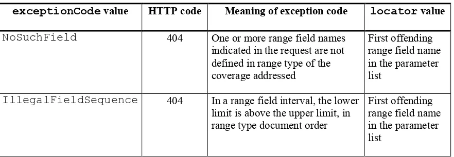
Table 4 — Exception codes for use of rangeSubset
exceptionCode value HTTP code Meaning of exception code locator value
NoSuchField 404 One or more range field names
indicated in the request are not defined in range type of the coverage addressed
First offending range field name in the parameter list
IllegalFieldSequence 404 In a range field interval, the lower limit is above the upper limit, in range type document order
11 Copyright © 2014 Open Geospatial Consortium. Annex A
(normative)
Abstract test suite
A Range Subsetting Extension implementation must satisfy the following system characteris-tics to be conformant with this specification.
Test identifiers below are relative to http://www.opengis.net/spec/WCS/2.0/WCS_service-extension_range-subsetting/1.0/conf.
A.1
Conformance Test Class:
record-subsetting
The OGC URI identifier of this conformance class is:
http://www.opengis.net/spec/WCS/2.0/conf/WCS_service-extension_range-subsetting/1.0/conf/record-subsetting.
A.1.1
Record-subsetting extension identifier
Test id: Test Purpose:
extension-identifier:
A WCS service implementing conformance class record-subsetting of this Range Subsetting Extension shall include the following URI in the Pro-file element of the ServiceIdentification in any GetCapabilities response:
http://www.opengis.net/spec/WCS_service-extension_range-subsetting/1.0/conf/record-subsetting
Test method: Send a GetCapabilities request to server under test, verify that the response contains a Profile element with said URI.
Test passes if all individual tests pass.
A.1.2
GetCoverage request syntax
Test id: Test Purpose:
getCoverage-request-syntax:
A GetCoverage request shall adhere to Figure 1, Table 3, and the XML schema defined for this Range Subsetting Extension whereby, in the XML request encoding, the GetCoverage wcs:Extension element shall con-tain exactly one RangeSubset element.
Test method: Send GetCoverage requests testing server response on the cases distin-guished in said reference. Check proper response.
12 Copyright © 2014 Open Geospatial Consortium
A.1.3
GetCoverage subsetting list
Test id: Test Purpose:
getCoverage-subsetting-list:
The RSub::RangeSubset parameter in a GetCoverage request, if pre-sent, shall have as its value a non-empty RSub::RangeItem list as speci-fied in Table 2, whereby each RSub::RangeItem is either a
RSub::RangeComponent or a RSub::RangeInterval.
Test method: Send GetCoverage requests to the service under test, evaluate whether re-sponses are adequate. Exercise tests for each of the following situations:
empty RSub::rangeItem
RSub::rangeItem is a RSub::rangeComponent
RSub::rangeItem is a RSub::rangeInterval
Test passes if all individual tests pass.
A.1.4
GetCoverage existing component
Test id: Test Purpose:
getCoverage-existing-component:
In the RSub::RangeSubset parameter of a GetCoverage request, for each RSub::RangeComponent there shall exist a corresponding com-ponent name in the range type of the coverage addressed.
Test method: Send GetCoverage requests to the service under test, evaluate whether re-sponses are adequate. Exercise tests for each of the following situations:
For each RSub::rangeComponent there exists a corresponding component name in the range type of the coverage addressed
There is a component name does not in the range type of the cover-age addressed
Test passes if all individual tests pass.
A.1.5
GetCoverage subsetting expansion
Test id: Test Purpose:
getCoverage-subsetting-expansion:
In the RangeSubset parameter of a GetCoverage request, if present, an RSub::RangeInterval with RSub::startComponent a and RSub::endComponent b shall be equivalent to a sequence of r1, …, rn where r1=a and rn=b and each ri is a range component name in the
original coverage’s range type and the sequence is sorted in document order of the original coverage’s range type.
ser-13 Copyright © 2014 Open Geospatial Consortium. vice under test, check proper response.
Test passes if all individual tests pass.
A.1.6
GetCoverage interval order
Test id: Test Purpose:
getCoverage-subsetting-interval-order:
In a RSub::RangeInterval with RSub::startComponent a and RSub::endComponent b contained in the RangeSubset parameter of
a GetCoverage request, range component ashall be before b or equal to b
(in document order) in the range component sequence of the RangeType of the coverage addressed.
Test method: Send a GetCoverage request with a correct RSub::rangeInterval to the service under test; check that result is not an exception.
Send a GetCoverage request with an RSub::rangeInterval containing a lower interval bound higher than the upper bound, according to range type document order; check that result is an IllegalFieldSequence excep-tion.
Test passes if all individual tests pass.
A.1.7
GetCoverage response
Test id: Test Purpose:
getCoverage-response-no-subsetting:
The response to a successful GetCoverage request containing no
RSub::RangeSubset parameter shall consist of a coverage whose range type contains exactly the original coverage’s range type elements in the proper sequence of this list.
Test method: Send a GetCoverage requestcontaining no RSub::rangeSubset parame-ter to the service under test, check that the result consists of a coverage whose range type contains exactly the original coverage’s range type ele-ments in the proper sequence of this list.
Test passes if all individual tests pass.
A.1.8
GetCoverage response component
Test Purpose: getCoverage-response-components:
The response to a successful GetCoverage request containing a
RSub::RangeSubset parameter consisting of list r1, …, rn of range
14 Copyright © 2014 Open Geospatial Consortium by r1, …, rn, in the proper sequence of this list.
Test method: Send a GetCoverage requestcontaining containing a RSub::rangeSubset parameter consisting of list r
1, …, rn of range
component names to the service under test, check that the result consists of a coverage whose range type contains exactly the original coverage’s range type elements identified by r1, …, rn, in the proper sequence of this list.
Test passes if all individual tests pass.
A.1.9
GetCoverage response content
Test id: Test Purpose:
getCoverage-response-contents:
The response to a successful GetCoverage request containing a
RSub::RangeSubset parameter consisting of list r1, …, rn of range
component names, for some n>0, shall consist of a coverage whose range set contains, for each domain coordinate of the coverage returned, exactly those components of the original coverage’s range set values which are identified by r1, …, rn, in the proper sequence of this list.
Test method: Send a GetCoverage requestcontaining containing a
RSub::rangeSubset parameter consisting of list r1, …, rn of range
component names to the service under test, check that the result consists of a coverage whose range set contains, for each domain coordinate of the coverage returned, exactly those components of the original coverage’s range set values which are identified by r1, …, rn, in the proper sequence
of this list.
Test passes if all individual tests pass.
A.1.10
KVP request list encoding
Test id: Test Purpose:
request-encoding-kvp-list:
In a GetCoverage request encoded in GET/KVP, the encoding of a RangeSubset parameter consisting of list r
1, …, rn of
RSub::RangeItems, for some n>1, shall consist of an ordered, comma-separated list of the r
i in their proper order.
Test method: Send aGET/KVP GetCoverage request containing the encoding of a rangeSubset parameter consisting an ordered, comma-separated list of RSub::rangeItems (n>1). Check proper response.
Test passes if all individual tests pass.
A.1.11
KVP request component encoding
15 Copyright © 2014 Open Geospatial Consortium. Test Purpose: In a GetCoverage request encoded in GET/KVP, the encoding of an
RSub::rangeComponent in a RSub::RangeSubset parameter shall consist of this component name.
Test method: Send a GET/KVP GetCoverage request containing the component name of of an RSub::rangeComponent. Check proper response.
Test passes if all individual tests pass.
A.1.12
KVP request interval encoding
Test id: Test Purpose:
request-encoding-kvp-interval:
In a GetCoverage request encoded in GET/KVP, the encoding of an RSub::RangeInterval in a RSub::RangeSubset parameter shall consist of the RSub::startComponent name followed by a colon (“:”) followed by the RSub::endComponent name.
Test method: Send a GET/KVP GetCoverage request containing the encoding of an RSub::rangeInterval parameter consisting of the RSub::start-Component name followed by a colon (“:”) followed by the RSub::end-Component name. Check proper response.
Test passes if all individual tests pass.
A.1.13
XML/Post request encoding
Test id: Test Purpose:
request-encoding-xml:
In a GetCoverage request encoded in XML/POST, the encoding of an RSub::rangeSubset shall consist of a structure as defined in the XML schema accompanying this standard
Test method: Send XML/POSTGetCoverage requests testing server response on the cas-es distinguished in said reference. Check proper rcas-esponse.
Test passes if all individual tests pass.
A.1.14
SOAP request encoding
Test id: Test Purpose:
request-encoding-soap:
In a GetCoverage request encoded in SOAP, the encoding of an
RSub::RangeSubset shall consist of a structure as defined in Figure 1, Table 2.
16 Copyright © 2014 Open Geospatial Consortium Test passes if all individual tests pass.