Publication Date: 2014-02-26
Approval Date: 2014-01-17
Submission Date: 2013-08-20
Reference number of this Document: OGC 12-049
External reference for this document: http://www.opengis.net/doc/IS/WCS-scaling-extension/1.0
Version:1.0
Category: OGC® Interface Standard Editor: Peter Baumann, Jinsongdi Yu
OGC® Web Coverage Service Interface Standard -
Interpolation Extension
Copyright © 2014 Open Geospatial Consortium.
To obtain additional rights of use, visit http://www.opengeospatial.org/legal/.
Warning
This document is an OGC Member approved international standard. This document is available on a royal-ty free, non-discriminatory basis. Recipients of this document are invited to submit, with their comments, notification of any relevant patent rights of which they are aware and to provide supporting documentation.
Document type: OGC Standard
Document subtype: Interface
Document stage: Approved
OGC 12-049
ii Copyright © 2014 Open Geospatial Consortium.
License Agreement
Permission is hereby granted by the Open Geospatial Consortium, ("Licensor"), free of charge and subject to the terms set forth below, to any person obtaining a copy of this Intellectual Property and any associated documentation, to deal in the Intellectual Property without restriction (except as set forth below), including without limitation the rights to implement, use, copy, modify, merge, publish, distribute, and/or sublicense copies of the Intellectual Property, and to permit persons to whom the Intellectual Property is furnished to do so, provided that all copyright notices on the intellectual property are retained intact and that each person to whom the Intellectual Property is furnished agrees to the terms of this Agreement.
If you modify the Intellectual Property, all copies of the modified Intellectual Property must include, in addition to the above copy-right notice, a notice that the Intellectual Property includes modifications that have not been approved or adopted by LICENSOR.
THIS LICENSE IS A COPYRIGHT LICENSE ONLY, AND DOES NOT CONVEY ANY RIGHTS UNDER ANY PATENTS THAT MAY BE IN FORCE ANYWHERE IN THE WORLD.
THE INTELLECTUAL PROPERTY IS PROVIDED "AS IS", WITHOUT WARRANTY OF ANY KIND, EXPRESS OR IMPLIED, INCLUDING BUT NOT LIMITED TO THE WARRANTIES OF MERCHANTABILITY, FITNESS FOR A PARTICULAR PURPOSE, AND NONINFRINGEMENT OF THIRD PARTY RIGHTS. THE COPYRIGHT HOLDER OR HOLDERS INCLUDED IN THIS NOTICE DO NOT WARRANT THAT THE FUNCTIONS CONTAINED IN THE INTELLECTUAL PROPERTY WILL MEET YOUR REQUIREMENTS OR THAT THE OPERATION OF THE INTELLECTUAL PROPERTY WILL BE
UNINTERRUPTED OR ERROR FREE. ANY USE OF THE INTELLECTUAL PROPERTY SHALL BE MADE ENTIRELY AT THE USER’S OWN RISK. IN NO EVENT SHALL THE COPYRIGHT HOLDER OR ANY CONTRIBUTOR OF
INTELLECTUAL PROPERTY RIGHTS TO THE INTELLECTUAL PROPERTY BE LIABLE FOR ANY CLAIM, OR ANY DIRECT, SPECIAL, INDIRECT OR CONSEQUENTIAL DAMAGES, OR ANY DAMAGES WHATSOEVER RESULTING FROM ANY ALLEGED INFRINGEMENT OR ANY LOSS OF USE, DATA OR PROFITS, WHETHER IN AN ACTION OF CONTRACT, NEGLIGENCE OR UNDER ANY OTHER LEGAL THEORY, ARISING OUT OF OR IN CONNECTION WITH THE IMPLEMENTATION, USE, COMMERCIALIZATION OR PERFORMANCE OF THIS INTELLECTUAL PROPERTY.
This license is effective until terminated. You may terminate it at any time by destroying the Intellectual Property together with all copies in any form. The license will also terminate if you fail to comply with any term or condition of this Agreement. Except as provided in the following sentence, no such termination of this license shall require the termination of any third party end-user subli-cense to the Intellectual Property which is in force as of the date of notice of such termination. In addition, should the Intellectual Property, or the operation of the Intellectual Property, infringe, or in LICENSOR’s sole opinion be likely to infringe, any patent, copyright, trademark or other right of a third party, you agree that LICENSOR, in its sole discretion, may terminate this license with-out any compensation or liability to you, your licensees or any other party. You agree upon termination of any kind to destroy or cause to be destroyed the Intellectual Property together with all copies in any form, whether held by you or by any third party.
Except as contained in this notice, the name of LICENSOR or of any other holder of a copyright in all or part of the Intellectual Prop-erty shall not be used in advertising or otherwise to promote the sale, use or other dealings in this Intellectual PropProp-erty without prior written authorization of LICENSOR or such copyright holder. LICENSOR is and shall at all times be the sole entity that may author-ize you or any third party to use certification marks, trademarks or other special designations to indicate compliance with any LICENSOR standards or specifications.
iii Copyright © 2014 Open Geospatial Consortium
Contents
Page
1
Scope ... 1
2
Conformance ... 1
3
Normative references ... 1
4
Terms and definitions ... 2
4.1
Interpolation (of a coverage) ... 2
5
Conventions ... 2
5.1
UML notation ... 2
5.2
Data dictionary tables ... 2
5.3
Namespace prefix conventions ... 2
5.4
Multiple representations ... 3
6
Interpolation
requirements class ... 3
6.1
Overview ... 3
6.2
Modifications to
GetCapabilities
... 3
6.3
Modifications to
DescribeCoverage
... 5
6.4
Modifications to
GetCoverage
... 5
6.4.1
Modifications to the
GetCoverage
request ... 5
6.4.2 Modifications to the
GetCoverage
response ... 5
6.5
Exceptions ... 6
6.6
Encodings ... 6
6.6.1 GET/KVP Encoding ... 6
6.6.2 XML/POST Encoding ... 6
6.6.3 SOAP Encoding ... 7
7
Interpolation-per-axis
requirements class ... 7
7.1
Overview ... 7
7.2
Modifications to
GetCapabilities
... 7
7.3
Modifications to
DescribeCoverage
... 7
7.4
Modifications to
GetCoverage
... 7
7.4.1 Modifications to the
GetCoverage
request ... 7
7.4.2 Modifications to the
GetCoverage
response ... 9
7.5
Exceptions ... 9
7.6
Encodings ... 10
7.6.1 GET/KVP Encoding ... 10
7.6.2 XML/POST Encoding ... 10
7.6.3 SOAP Encoding ... 11
Bibliography ... 12
Annex A (normative) Abstract test suite ... 13
A.1
Conformance Test Class:
interpolation
... 13
A.1.1
Interpolation/interpolation identifier ... 13
A.1.2
Interpolation/capabilities ... 13
OGC 12-049
iv Copyright © 2014 Open Geospatial Consortium.
A.1.4
Interpolation/wcs ServiceMetadata interpolation Methods ... 14
A.1.5
Interpolation/interpolation GetCoverage request ... 14
A.1.6
Interpolation/interpolation GetCoverage response ... 14
A.1.7
Interpolation/interpolation per axis GetCoverage getkvp ... 15
A.1.8
Interpolation/interpolation per axis GetCoverage xmlpost ... 15
A.1.9
Interpolation/interpolation per axis GetCoverage soap ... 15
A.1.10
Interpolation-per-axis/identifier ... 16
A.1.11
Interpolation-per-axis/getCoverage request ... 16
A.1.12
Interpolation-per-axis/getCoverage axes ... 16
A.1.13
Interpolation-per-axis/getCoverage-axes-pairwise-distinct ... 16
A.1.14
Interpolation-per-axis/getCoverage existing axis ... 17
A.1.15
Interpolation-per-axis/getCoverage response ... 17
A.1.16
Interpolation-per-axis/getCoverage getkvp ... 18
A.1.17
Interpolation-per-axis/getCoverage xmlpost ... 18
v Copyright © 2014 Open Geospatial Consortium
Tables
PageTable 1 — Conformance class dependencies ... 2
Table 2 — Namespace mappings ... 3
Table 3 — Components of Int::InterpolationMetadata structure ... 4
Table 4 — Components of Int::InterpolationMethod structure ... 5
Table 5 — Exception codes for use of Interpolation ... 6
Table 6 — Components of Int::InterpolationAxis structure ... 8
OGC 12-049
vi Copyright © 2014 Open Geospatial Consortium.
i.
Abstract
This OGC standard specifies parameters to the OGC Web Coverage Service (WCS) GetCov-erage request which give control over interpolation of a covGetCov-erage during its server-side pro-cessing. This allows the client (user) to control and specify the interpolation mechanism to be applied to a coverage during server processing.
This WCS Interpolation extension relies on WCS Core [OGC 09-110r4] and the GML Appli-cation Schema for Coverages [OGC 09-146r2].
ii.
Keywords
ogcdoc, wcs, interpolation
iii.
Terms and definitions
This document uses the standard terms defined in Subclause 5.3 of [OGC 06-121r9], which is based on the ISO/IEC Directives, Part 2, Rules for the structure and drafting of International Standards. In particular, the word “shall” (not “must”) is the verb form used to indicate a requirement to be strictly followed to conform to this standard.
iv.
Submitting organizations
The following organizations have submitted this Interface Specification to the Open Geospa-tial Consortium, Inc.:
Jacobs University Bremen Fuzhou University
v.
Document Contributor Contact Points
vi.
Changes to the OGC
®Abstract Specification
The OGC® Abstract Specification does not require any changes to accommodate the technical contents of this (part of this) document.
vii.
Future Work
Among the topics for future development are the following items:
Name Organization
Peter Baumann Jacobs University Bremen, rasdaman GmbH
Jinsongdi Yu Fuzhou University
vii Copyright © 2014 Open Geospatial Consortium
OGC 12-049
viii Copyright © 2014 Open Geospatial Consortium.
Foreword
This WCS Interpolation extension is an OGC Interface Standard which relies on WCS Core [OGC 09-110r4] and the GML Application Schema for Coverages [OGC 09-146r2].
This document includes one normative Annex.
Attention is drawn to the possibility that some of the elements of this document may be the subject of patent rights. The Open Geospatial Consortium shall not be held responsible for identifying any or all such patent rights.
ix
Copyright © 2014 Open Geospatial Consortium
Introduction
The OGC Web Coverage Service (WCS) –Interpolation Extension defines an extension to the WCS Core [OGC 09-110r4] to control interpolation during processing of a GetCoverage request. This affects all operations that require interpolation, such as scaling and CRS change.
Note As such, this Interpolation Extension has impact on the operational behaviour described in other WCS extensions, such as the ones mentioned above.
On principle, the set of interpolation types supported is a property of a coverage. Actually, interpolation can be even more localized and constitute a property of particular coverage axes and on particular bands. For example, a coverage may undergo linear interpolation along lat/long axes and nearest neighbour interpolation along time.
However, modelling interpolation this fine-grain would pose severe load on WCS implemen-tations and concrete services. Server implementation is complicated substantially by a dy-namic per-axis choice of interpolation methods applied. Reporting interpolation capabilities with individual coverages would lead to substantially larger metadata, and would substantial-ly complicate client-side handling of this information.
Therefore, a mixed approach has been adopted. In the core conformance class of this stand-ard, one interpolation method can be selected by the client which subsequently gets applied along all coverage axes simultaneously. In an optional further conformance class, interpola-tion-per-axis, for each axis an override can be indicated using a different interpolation meth-od.
Interpolation methods available are reported by the service in its GetCapabilities response; a normative set of specific interpolation techniques is provided by OGC Abstract Topic 6 (which is identical to ISO 19123) [1]; OGC-NA might normatively establish URLs for such interpolation methods.
1 Copyright © 2014 Open Geospatial Consortium.
OGC® Web Coverage Service Interface Standard -
Interpolation Extension
1 Scope
This OGC WCS Interpolation Extension – in short: Interpolation Extension – defines how a client can control interpolation performed by a server during GetCoverage interpolation, should an interpolation occur in the course of request evaluation.
2 Conformance
This document establishes the following requirements and conformance classes:
interpolation, of URI http://www.opengis.net/spec/WCS_service-extension_
interpo-lation/1.0/req/interpolation; the corresponding conformance class is interpolation, with URI
http://www.opengis.net/spec/WCS_service-extension_interpolation/1.0/conf/interpolation.
This is the mandatory core conformance class of this extension.
interpolation-per-axis, of URI
http://www.opengis.net/spec/WCS_service-extension_interpolation/1.0/req/interpolation-per-axis; the corresponding conform-ance class is interpolation-per-axis, with URI
http://www.opengis.net/spec/WCS_service-extension_interpolation/1.0/conf/interpolation-per-axis.
Standardisation target of all requirements and conformance classes are WCS implementations (currently: servers).
Requirements URIs defined in this document are relative to
http://www.opengis.net/spec/WCS_service-extension_interpolation/1.0/req, conformance test URIs defined in this document are relative to http://www.opengis.net/spec/WCS_service-extension_interpolation/1.0/conf.
Annex A lists the conformance tests which shall be exercised on any software artefact claim-ing to implement WCS.
3 Normative references
This OGC WCS Interpolation Extension specification consists of the present document and an XML Schema. The complete specification is identified by OGC URI
http://www.opengis.net/spec/WCS_service-extension_interpolation/1.0, the document has OGC URI http://www.opengis.net/doc/IS/WCS_service-extension_interpolation/1.0. The complete specification is available for download from
reposi-OGC 12-049
2 Copyright © 2014 Open Geospatial Consortium.
tory. In the event of a discrepancy between bundled and schema repository versions of the XML Schema files, the schema repository shall be considered authoritative.
The normative documents listed in Table 1 contain provisions that, through reference in this text, constitute provisions of this specification. For dated references, subsequent amendments to, or revisions of, any of these publications do not apply. For undated references, the latest edition of the normative document referred to applies.
Table 1 — Conformance class dependencies
Range subsetting conformance class
Dependency document Dependency
con-formance class
interpolation OGC 09-110, OGC® Web Coverage Service 2.0
Interface Standard - Core, version 2.0
core
interpolation-per-axis
This specification interpolation
4 Terms and definitions
For the purposes of this document, the terms and definitions given in the above references apply. In addition, the following terms and definitions apply. An arrow ““ indicates that the following term is defined in this Clause.
4.1 Interpolation (of a coverage)
Estimation of a – non-existing – range value of a coverage for a location in the coverage which is situated between positions containing range values
5 Conventions
5.1 UML notation
Unified Modeling Language (UML) static structure diagrams appearing in this specification are used as described in Subclause 5.2 of OGC Web Services Common [OGC 06-121r9]. 5.2 Data dictionary tables
The UML model data dictionary is specified herein in a series of tables. The contents of the columns in these tables are described in Subclause 5.5 of [OGC 06-121r9]. The contents of these data dictionary tables are normative, including any table footnotes.
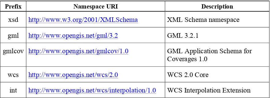
5.3 Namespace prefix conventions
3 Copyright © 2014 Open Geospatial Consortium. Table 2 — Namespace mappings
Prefix Namespace URI Description
xsd http://www.w3.org/2001/XMLSchema XML Schema namespace gml http://www.opengis.net/gml/3.2 GML 3.2.1
gmlcov http://www.opengis.net/gmlcov/1.0 GML Application Schema for Coverages 1.0
wcs http://www.opengis.net/wcs/2.0 WCS 2.0 Core
int http://www.opengis.net/wcs/interpolation/1.0 WCS Interpolation Extension
5.4 Multiple representations
When multiple representations of the same information are given in a specification document these are consistent. Should this not be the case then this is considered an error, and the XML schema shall take precedence.
6 Interpolation requirements class
6.1 Overview
This Clause 6 establishes the Interpolation Extension core conformance class, interpolation. Clients and servers supporting this requirements class allow choosing an interpolation meth-od to be applied whenever interpolation takes place during GetCoverage request evaluation. The interpolation method chosen is applied simultaneously along all axes.
6.2 Modifications to GetCapabilities
A server announces support of the scaling conformance class to a client by adding the URL identifying this extension to the list of supported extensions delivered in the Capabilities document.
Requirement 1 interpolation/interpolation-identifier:
A WCS service implementing conformance class interpolation of this Interpolation Exten-sion shall include the following URI in the Profile element of the ServiceIdentifi-cation in a GetCapabilities response:
http://www.opengis.net/spec/WCS_service-extension_interpolation/1.0/conf/interpolation
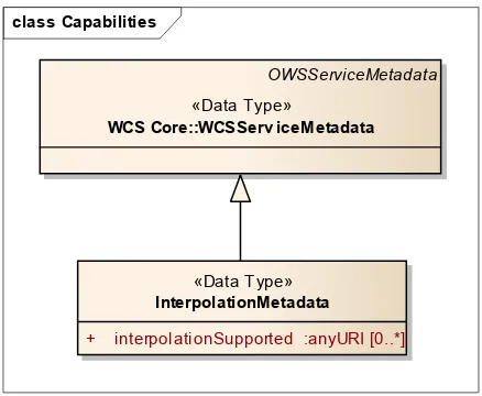
Requirement 2 interpolation/capabilities:
The response to a successful GetCapabilities request shall adhere to Figure 1, Table 2, and the XML schema defined for this Interpolation Extension.
OGC 12-049
4 Copyright © 2014 Open Geospatial Consortium.
Figure 1 — Capabilities UML diagram with InterpolationMetadata component
Table 3 — Components of Int::InterpolationMetadata structure
Name Definition Data type Multiplicity
interpolation-Supported
Identifier(s) of interpolation meth-od(s) supported by the server
List of
anyURI
zero or more (optional) Requirement 3 interpolation/wcsServiceMetadata:
The response to a successful GetCapabilities request shall contain an Interpolation-Metadata element.
Example The following list is returned in the Capabilities document of a server supporting nearest-neighbor, linear, and quadratic interpolation (URLs are fictitious; see OGC-NA for actually standardized interpolation URIs):
<int:InterpolationMetadata> <int:InterpolationSupported>
http://www.opengis.net/def/interpolation/OGC/1/nearest-neighbor </int:InterpolationSupported>
<int:InterpolationSupported>
http://www.opengis.net/def/interpolation/OGC/1/linear </int:InterpolationSupported>
<int:InterpolationSupported>
http://www.opengis.net/def/interpolation/OGC/1/quadratic </int:InterpolationSupported>
</int:InterpolationMetadata>
Requirement 4 interpolation/wcsServiceMetadata-interpolationMethods:
The interpolationSupported item(s) delivered in the ServiceMetadata element of the response to a successful GetCapabilities request shall consist of a pairwise distinct list of URLs.
Note The above requirement tentatively does not constrain the admitted URLs to those defined in the *-interpolation requirements classes of this document. This allows vendors to support further types of in-terpolation. However, implementations should use the interpolation URLs for those interpolation types this standard provides definitions for.
class Capabilities
«Data Type»
InterpolationMetadata
+ interpolationSupported :anyURI [0..*] OWSServi ceMetadata
«Data Type»
5 Copyright © 2014 Open Geospatial Consortium. 6.3 Modifications to DescribeCoverage
None.
6.4 Modifications to GetCoverage
6.4.1 Modifications to the GetCoverage request
The GetCoverage request is extended with a parameter, globalInterpolation, deter-mining what interpolation technique is to be applied by the server when preparing the GetCoverage response; this interpolation is applied uniformly on all axes of the resulting coverage.
Note This will be extended in the requirements class defined in Clause 7; the representation in this UML diagram has been prepared for this, explaining why it could be simplified theoretically. Further, the pertaining XML Schema of this Interpolation Extension contains all variants.
Requirement 5 interpolation/GetCoverage-request:
A GetCoverage request shall adhere to Figure 2, Table 3, and the XML schema defined for this Interpolation Extension.
Figure 2 — GetCoverage with interpolation support UML diagram
Table 4 — Components of Int::InterpolationMethod structure
Name Definition Data type Multiplicity
globalInterpo-lation
Interpolation method to be applied on all axes during GetCoverage result prepara-tion
anyURI one
(mandatory)
6.4.2 Modifications to the GetCoverage response
Requirement 6 interpolation/GetCoverage-response:
The contents of the response to a successful GetCoverage request containing an
Int::globalInterpolation parameter with value m shall be obtained by applying
in-cla etCov eraeWithInterpolation
RequestBase
«DataType»
WCS Core::etCov erae
+ coverageId :NCName
+ request :CharacterString = GetCoverage {readOnly}
«Data Type»
etCov eragWithnterpolation
OGC 12-049
6 Copyright © 2014 Open Geospatial Consortium.
terpolation method m any time interpolation takes place during preparation of the response, and along every axis of the coverage being processed.
Note This interpolation is applied uniformly along all axes of the coverages.
6.5 Exceptions
Table 5 — Exception codes for use of Interpolation
exceptionCode value HTTP
code
Meaning of exception code locator value
InterpolationMethod-NotSupported
404 interpolation parameter indicated is not supported by this server (i.e., URL is not known to
In a GetCoverage request using the GET/KVP protocol as specified in [OGC 09-147r2], an
Int::globalInterpolation parameter shall be represented as
INTERPOLATION=m
where m is an interpolation method identifier.
Example The following KVP fragment resembles a valid interpolation request parameter:
…& INTERPOLATION=
http://www.opengis.net/def/interpolation/OGC/1/linear &…
6.6.2 XML/POST Encoding
Requirement 8 interpolation/GetCoverage-xmlpost:
In a GetCoverage request using the XML/POST protocol as specified in [OGC 09-148r2], an
Int::globalInterpolation parameter shall be represented by a GML
int:globalInterpolation element.
Example The XML fragments below resemble the same example cases as the GET/KVP fragment above.
<int:Interpolation>
<int:globalInterpolation>
http://www.opengis.net/def/interpolation/OGC/1/linear </int:globalInterpolation/>
7 Copyright © 2014 Open Geospatial Consortium. 6.6.3 SOAP Encoding
Requirement 9 interpolation/GetCoverage-soap:
In a GetCoverage request using the SOAP protocol, an Int::globalInterpolation
parameter shall be represented by a GML int:globalInterpolation element.
Example See previous subclause.
7 Interpolation-per-axis requirements class
7.1 Overview
This Clause 7 establishes the optional Interpolation Extension conformance class, interpola-tion-per-axis. This conformance class specifies how to request and obtain coverages where individual interpolation modes can be applied independently to each axis of the coverage under processing. For those axes where no interpolation is specified in the
interpolation-per-axis structures, the default interpolation method passed in the core parameter,
Int::glo-balInterpolation, applies. 7.2 Modifications to GetCapabilities
Requirement 10interpolation-per-axis/identifier:
A WCS service implementing conformance class interpolation-per-axis of this Interpolation Extension shall include the following URI in the Profile element of the ServiceI-dentification in a GetCapabilities response:
http://www.opengis.net/spec/WCS_service-extension_interpolation/1.0/conf/interpolation-per-axis
7.3 Modifications to DescribeCoverage
None.
7.4 Modifications to GetCoverage
7.4.1 Modifications to the GetCoverage request
Requirement 11interpolation-per-axis/getCoverage-request:
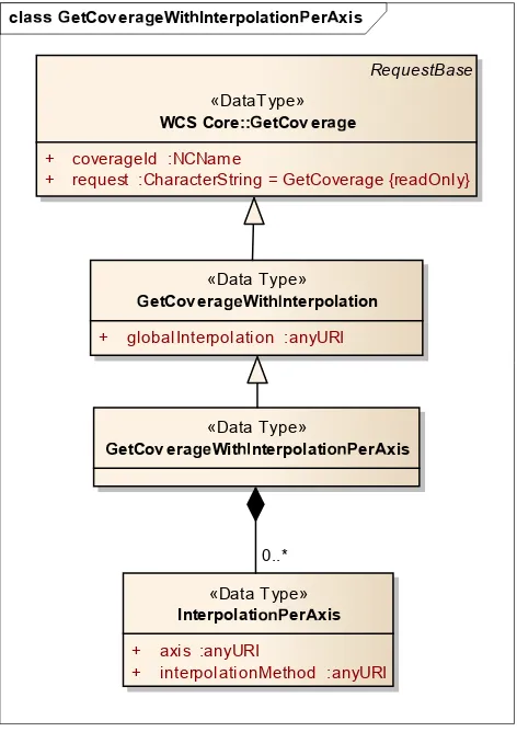
The Int::InterpolationPerAxis parameter in a GetCoverage request, if present, shall have a structure as defined in Figure 3 and Table 6.
Dependency:
OGC 12-049
8 Copyright © 2014 Open Geospatial Consortium.
Figure 3 — GetCoverage with interpolation-per-axis support UML diagram
Individually for each axis of the coverage, separate interpolation methods can be indicated. Requirement 12interpolation-per-axis/getCoverage-axes:
The Int::InterpolationPerAxis parameters in a GetCoverage request, if present, shall consist of an unordered sequence of Int::InterpolationPerAxis elements with a structure as defined in Table 6.
Table 6 — Components of Int::InterpolationAxis structure
Name Definition Data type Multiplicity
axis Coverage axis along which the interpo-lation method is to be applied
anyURI one
(mandatory)
Interpolation-Method
Interpolation method to be applied along the specified axis during GetCoverage result preparation
anyURI one
(mandatory)
Each axis in the CRS of the coverage can appear at most once, to avoid ambiguities.
cletCov ereWitInterpolationPerAxis
RequestBase
«DataType»
WCS Core::etCov ere
+ coverageId :NCName
+ request :CharacterString = GetCoverage {readOnly}
«Data Type»
Interpolatio PerAxis
+ axis :anyURI
+ interpolationMethod :anyURI
«Data Type»
etCov eraWitnterpolation
+ globalInterpolation :anyURI
«Data Type»
etCov eraWitnterpolatio PerAxis
9 Copyright © 2014 Open Geospatial Consortium. Requirement 13interpolation-per-axis/getCoverage-axes-pairwise-distinct:
In a GetCoverage request containing Int::InterpolationPerAxis parameters, all ax-is values shall be pairwise distinct.
Requirement 14interpolation-per-axis/getCoverage-existing-axis:
The axis value of each Int::InterpolationPerAxis parameter in a GetCoverage request shall be identical to the axisAbbrev element of some CRS axis of the CRS identi-fied by the srsName attribute in the gml:Envelope element of the coverage generated.
Note Interpolation always is done towards a target structure (such as an output grid). In presence of an OUTPUTCRS parameter according to the WCS CRS Extension [OGC 11-053], therefore, interpolation has to be expressed on the axes of the CRS indicated in OUTPUTCRS. Otherwise, the coverage’s Native CRS is used.
7.4.2 Modifications to the GetCoverage response
Requirement 15interpolation-per-axis/getCoverage-response:
The contents of the response to a successful GetCoverage request containing n>0
Int::InterpolationPerAxis parameters consisting of a1,…,an axis identifiers and m1,…,mn interpolation methods shall be obtained by applying interpolation method mi on axis ai any time interpolation takes place during preparation of the GetCoverage response; for those axes not appearing in this list, the method indicated in the
int:globalInterpolation parameter shall be applied.
Example The following is a valid GET/KVP request snippet (see Subclause 7.6) specifying that in gen-eral (such as lat, long, height, or whatever axis is present in the coverage) linear interpolation is to be ap-plied, only along the time axis nearest-neighbor is requested (assuming the coverage addressed contains such a temporal axis):
…& INTERPOLATION=
http://www.opengis.net/def/interpolation/OGC/1/linear & INTERPOLATIONPERAXIS=phenomenon-time,
http://www.opengis.net/def/interpolation/OGC/1/nearest-neighbor &…
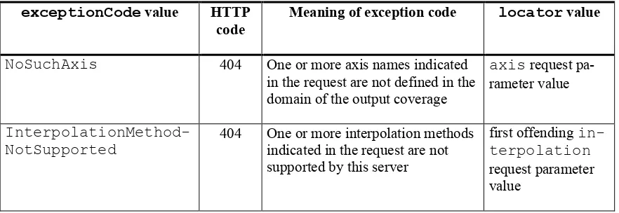
7.5 Exceptions
Table 7 — Exception codes for use of InterpolationPerAxis
exceptionCode value HTTP
code
Meaning of exception code locator value
NoSuchAxis 404 One or more axis names indicated
in the request are not defined in the domain of the output coverage
axis request pa-rameter value
InterpolationMethod-NotSupported
404 One or more interpolation methods indicated in the request are not supported by this server
first offending in-terpolation
OGC 12-049
10 Copyright © 2014 Open Geospatial Consortium.
7.6 Encodings
7.6.1 GET/KVP Encoding
Requirement 16interpolation-per-axis/getCoverage-getkvp:
In a GetCoverage request using the GET/KVP protocol as specified in [OGC 09-147r2], an
Int::Interpolation parameter containing n>0 (Int::axis,
Int::interpolat-ionMethod) components (a
1:m1),…,(an:mn) shall be represented as
INTERPOLATIONPERAXIS=a1,m1
& …
& INTERPOLATIONPERAXIS=an,mn
Example The following KVP fragment resembles a valid interpolation request:
…& INTERPOLATION=
http://www.opengis.net/def/interpolation/OGC/1/linear & INTERPOLATIONPERAXIS=lat,
http://www.opengis.net/def/interpolation/OGC/1/quadratic & INTERPOLATIONPERAXIS=long,
http://www.opengis.net/def/interpolation/OGC/1/quadratic & INTERPOLATIONPERAXIS=height,
http://www.opengis.net/def/interpolation/OGC/1/cubic & INTERPOLATIONPERAXIS=phenomenon-time,
http://www.opengis.net/def/interpolation/OGC/1/nearest-neighbor &…
7.6.2 XML/POST Encoding
Requirement 17interpolation-per-axis/getCoverage-xmlpost:
In a GetCoverage request using the XML/POST protocol as specified in [OGC 09-148r2], the
Int::InterpolationPerAxis parameters, if present, shall be represented by GML
int:InterpolationPerAxis elements.
Example The XML fragments below resemble the same example cases as the GET/KVP fragment above.
<int:Interpolation>
<int:globalInterpolation>
http://www.opengis.net/def/interpolation/OGC/1/linear </int:globalInterpolation>
<int:InterpolationPerAxis> <int:axis>lat</int:axis> <int:interpolationMethod>
http://www.opengis.net/def/interpolation/OGC/1/quadratic </int:interpolationMethod>
</int:InterpolationPerAxis> <int:InterpolationPerAxis> <int:axis>long</int:axis> <int:interpolationMethod>
http://www.opengis.net/def/interpolation/OGC/1/quadratic </int:interpolationMethod>
11 Copyright © 2014 Open Geospatial Consortium.
<int:interpolationMethod>
http://www.opengis.net/def/interpolation/OGC/1/cubic </int:interpolationMethod>
</int:InterpolationPerAxis> <int:InterpolationPerAxis>
<int:axis>phenomenon-time</int:axis> <int:interpolationMethod>
http://www.opengis.net/def/interpolation/OGC/1/nearest-neighbor </int:interpolationMethod>
</int:InterpolationPerAxis> </int:Interpolation>
7.6.3 SOAP Encoding
Requirement 18interpolation-per-axis/getCoverage-soap:
In a GetCoverage request using the SOAP protocol as specified in [OGC 09-149r1], the
int::InterpolationPerAxis parameters, if present, shall be represented by GML
int:InterpolationPerAxis elements.
OGC 12-049
12 Copyright © 2014 Open Geospatial Consortium.
Bibliography
13 Copyright © 2014 Open Geospatial Consortium. Annex A
(normative)
Abstract test suite
An Interpolation Extension implementation must satisfy the following system characteristics to be conformant with this specification.
Test identifiers below are relative to http://www.opengis.net/spec/WCS/2.0/WCS_service-extension_interpolation/1.0/conf.
.
Conformance Test Class:
interpolation
The OGC URI identifier of this conformance class is:
http://www.opengis.net/spec/WCS/2.0/conf/WCS_service-A WCS service implementing conformance class interpolation of this In-terpolation Extension shall include the following URI in the Profile el-ement of the ServiceIdentification in a GetCapabilities response:
http://www.opengis.net/spec/WCS_service-extension_interpolation/1.0/conf/interpolation
Test method: Send a GetCapabilities request to server under test, verify that the response contains a Profile element with said URI.
Test passes if result is as expected.
. . I
capabilities
Test id: Test Purpose:
interpolation/capabilities:
The response to a successful GetCapabilities request shall adhere to Figure 1, Table 2, and the XML schema defined for this Interpolation Extension. Test method: Send a GetCapabilities to server under test, and check for proper response.
Test passes if result is as expected.
. . I
wcs ServiceMetadata
Test id: Test Purpose:
interpolation/wcsServiceMetadata:
OGC 12-049
14 Copyright © 2014 Open Geospatial Consortium.
Test method: Send a GetCapabilities request to server under test, verify that the response contains an InterpolationMetadata element.
Test passes if result is as expected.
! " #$ %& '$ (
wcs ServiceMetadata interpolation Methods
Test id: Test Purpose:
interpolation/wcsServiceMetadata-interpolationMethods:
The interpolationSupported item(s) delivered in the ServiceM-etadata element of the response to a successful GetCapabilities request shall consist of a pairwise distinct list of URLs.
Test method: Send a GetCapabilities request to server under test, check that the inter-polationSupported item(s) of the response consist of a pairwise dis-tinct list of URLs.
Test passes if result is as expected.
) ! " #$ %& '$ (
interpolation
G! *$ +erage request
Test id: Test Purpose:
interpolation/GetCoverage-request:
A GetCoverage request shall adhere to Figure 2, Table 3, and the XML schema defined for this Interpolation Extension.
Test method: Send GetCoverage requests testing server response on the cases distin-guished in said reference. Check for proper response.
Test passes if expected result is delivered.
, ! " #$ %& '$ (
interpolation
G! *$ +erage response
Test id: Test Purpose:
interpolation/GetCoverage-response:
The contents of the response to a successful GetCoverage request contain-ing an Int::globalInterpolation parameter with value m shall be obtained by applying interpolation method m any time interpolation takes place during preparation of the response, and along every axis of the cover-age being processed.
Test method: Send a GetCoverage request containing an int::globalInterpolat-ion parameter to server under test, verify that the response is not an excep-tion.
15 Copyright © 2014 Open Geospatial Consortium.
- /0 /1 23 45 6 78 9: 4;8 3 <
interpolation per axis
=etCoverage getkvp
Test id: Test Purpose:
interpolation/GetCoverage-getkvp:
In a GetCoverage request using the GET/KVP protocol as specified in [OGC 09-147r2], an Int::globalInterpolation parameter shall be represented as
INTERPOLATION=m
where m is an interpolation method identifier.
Test method: Send a Get/KVP GetCoverage request containing an int::global-Interpolation parameter represented as
INTERPOLATION=m to server under test, verify that the response is not an exception.
Test passes if result is as expected.
- /0 /> 23 45 6 78 9: 4;8 3 <
interpolation per axis
=5 4?8@erage xmlpost
Test id: Test Purpose:
interpolation/GetCoverage-xmlpost:
In a GetCoverage request using the XML/POST protocol as specified in [OGC 09-148r2], an Int::globalInterpolation parameter shall be represented by a GML int:globalInterpolation element.
Test method: Send a XML/POST GetCoverage request containing an Interpola-tion::InterpolationMethod parameter represented by an
int::InterpolationMethod element, verify that the response is not an exception.
Test passes if result is as expected.
- /0 /B 23 45 6 78 9: 4;8 3 <
interpolation per axis
=5 4?8@erage soap
Test id: Test Purpose:
interpolation/GetCoverage-soap:
In a GetCoverage request using the SOAP protocol, an Int::global-Interpolation parameter shall be represented by a GML
int:globalInterpolation element.
Test method: Send a SOAP GetCoverage request containing an Interpola-tion::InterpolationMethod parameter represented by an
int::InterpolationMethod element, verify that the response is not an exception.
OGC 12-049
16 Copyright © 2014 Open Geospatial Consortium.
C DE D EF
Interpolation
Hper
Haxis
JKL MN OK QK MRTest id: Test Purpose:
interpolation-per-axis/identifier:
A WCS service implementing conformance class interpolation-per-axis of this Interpolation Extension shall include the following URI in the Pro-file element of the ServiceIdentification in a GetCapabilities response:
http://www.opengis.net/spec/WCS_service-extension_interpolation/1.0/conf/interpolation-per-axis
Test method: Send a GetCapabilities request to server under test, verify that the response contains a Profile element with said URI.
Test passes if result is as expected.
C DE D EE
Interpolation
Hper
HS TKUJVM OW XYerage request
Test id: Test Purpose:
interpolation-per-axis/getCoverage-request:
The Int::InterpolationPerAxis parameter in a GetCoverage re-quest, if present, shall have a structure as defined in Figure 3 and Table 6. Dependency:
Clause 6, http://www.opengis.net/doc/IS/WCS_service-extension_interpolation/1.0/Clause-6
Test method: Send GetCoverage requests testing server response on the cases distin-guished in said reference, and check for proper response.
Test passes if expected result is delivered.
C DE D EZ
Interpolation
Hper
Haxis
JgetCoverage axes
Test id: Test Purpose:
interpolation-per-axis/getCoverage-axes:
The Int::InterpolationPerAxis parameters in a GetCoverage re-quest, if present, shall consist of an unordered sequence of Int::Inter-polationPerAxis elements with a structure as defined in Table 6. Test method: Send GetCoverage requests testing server response on the cases
distin-guished in said reference, and check for proper response. Test passes if expected result is delivered.
C DE D E[
Interpolation
Hper
HS TKUJgetCoverage
Haxes
Hpairwise
Hdistinct
Test id: Test Purpose:
interpolation-per-axis/getCoverage-axes-pairwise-distinct:
In a GetCoverage request containing Int::InterpolationPerAxis
17 Copyright © 2014 Open Geospatial Consortium. Test method: Send GetCoverage requests to the service under test containing:
two int::InterpolationPerAxis elements with different axis names. Verify that request succeeds.
two int::InterpolationPerAxis elements with identical axis names. Verify that request fails.
Test passes if expected result is delivered.
\ ]^ ] ^_
Interpolation
`per
`b c de fietCoverage existing axis
Test id: Test Purpose:
The axis value of each Int::InterpolationPerAxis parameter in a
GetCoverage request shall be identical to the axisAbbrev element of
some CRS axis of the CRS identified by the srsName attribute in the
gml:Envelope element of the coverage generated.
Test method: Send GetCoverage requests to the service under test, with an Interpola-tion::InterpolationAxis parameter contains an axis element which is:
identical to the identifier of a domain axis in the coverage ad-dressed. Verify that request succeeds.
not identical to any domain axis identifier in the coverage ad-dressed. Verify that request fails.
Test passes if expected result is delivered.
\ ]^ ] ^j
Interpolation
`per
`axis
fgetCoverage response
Test id: Test Purpose:
interpolation-per-axis/getCoverage-response:
The contents of the response to a successful GetCoverage request contain-ing n>0 Int::InterpolationPerAxis parameters consisting of a1,…,an axis identifiers and m1,…,mn interpolation methods shall be ob-tained by applying interpolation method mi on axis ai any time interpola-tion takes place during preparainterpola-tion of the GetCoverage response; for those axes not appearing in this list, the method indicated in the
int:globalInterpolation parameter shall be applied.
Test method: Send a GetCoverage request containing, an Interpolation::Inter-polationAxes parameter with n>0
OGC 12-049
18 Copyright © 2014 Open Geospatial Consortium.
k lm l mn
Interpolation
pper
pq r st uvetCoverage getkvp
Test id: Test Purpose:
interpolation-per-axis/getCoverage-getkvp:
In a GetCoverage request using the GET/KVP protocol as specified in [OGC 09-147r2], an Int::Interpolation parameter containing n>0
(Int::axis, Int::interpolationMethod) components
(a1:m1),…,(an:mn) shall be represented as
INTERPOLATIONPERAXIS=a
1,m1
& …
& INTERPOLATIONPERAXIS=an,mn
Test method: Send a GET/KVP GetCoverage request containing an
Int::Interpolation parameter containing n>0
Int::Inter-polationAxis components represented as INTERPOLATIONPERAXIS =a1:m1,…,an:mn, where each ai is an axis identifier URL and each mi is an interpolation identifier URL, verify that the response is not an exception. Test passes if result is as expected.
k lm l mw
Interpolation
pper
pq r st uvx yz {|erage xmlpost
Test id: Test Purpose:
interpolation-per-axis/getCoverage-xmlpost:
In a GetCoverage request using the XML/POST protocol as specified in [OGC 09-148r2], the Int::InterpolationPerAxis parameters, if present, shall be represented by GML int:InterpolationPerAxis
elements.
Test method: Send a valid XML/POST GetCoverage request containing int:: Inter-polationPerAxis elements, verify that the response is not an excep-tion.
Test passes if result is as expected.
k lm l m}
Interpolation
pper
pq r st uvetCoverage
psoap
Test id: Test Purpose:
interpolation-per-axis/getCoverage-soap:
In a GetCoverage request using the SOAP protocol as specified in [OGC 09-149r1], the int::InterpolationPerAxis parameters, if present, shall be represented by GML int:InterpolationPerAxis elements. Test method: Send a SOAP GetCoverage request containing int::Interpolation
elements, verify that the response is not an exception. Test passes if result is as expected.
19 Copyright © 2014 Open Geospatial Consortium. Annex B: Revision history
Date Release Author Paragraph modified Description
2012-06-20 0.0.1 Peter Baumann All Created
2012-08-12 0.0.2 Peter Baumann All Formalized requirements
2012-12-03 0.1.0 Peter Baumann, JinosngdiYu
Several, in particular: Annex A
Completed, added ATS 2014-01-01 1.0.0 Peter Baumann,
Jin-songdi Yu
All Finalized after adoption vote;