Open Geospatial Consortium
Approval Date: 2012-12-04
Publication date: 2013-03-26
Reference number of this OGC® Project Document: OGC 09-147r3
Version:1.0.1
Category: OGC® Interface Standard Corrigendum
Editor: Peter Baumann
OGC® Web Coverage Service 2.0 Interface Standard -
KVP Protocol Binding Extension - Corrigendum
Copyright © 2013 Open Geospatial Consortium
To obtain additional rights of use, visit http://www.opengeospatial.org/legal/.
Warning
This document is corrigendum for an existing OGC standard. This document is available on a royalty free, non-discriminatory basis. Recipients of this document are invited to submit, with their comments, notification of any relevant patent rights of which they are aware and to pro-vide supporting documentation.
Document type: OGC®Interface Standard Corrigendum Document subtype: Corrigendum
Document stage: Approved OGC Standard Document language: English
Greg Buehler 3/26/13 1:40 PM
OGC 09-147r3
ii Copyright © 2013 Open Geospatial Consortium
Greg Buehler 3/26/13 1:41 PM
Formatted: Font:11 pt
Greg Buehler 3/26/13 1:41 PM
Deleted: Copyright © 2013 Open Geospatial Consortium
License Agreement
Permission is hereby granted by the Open Geospatial Consortium, ("Licensor"), free of charge and subject to the terms set forth below, to any person obtaining a copy of this Intellectual Property and any associated documentation, to deal in the Intellectual Property without restriction (except as set forth below), including without limitation the rights to implement, use, copy, modify, merge, publish, distribute, and/or sublicense copies of the Intellectual Property, and to permit persons to whom the Intellectual Property is furnished to do so, provided that all copyright notices on the intellectual property are retained intact and that each person to whom the Intellectual Property is furnished agrees to the terms of this Agreement.
If you modify the Intellectual Property, all copies of the modified Intellectual Property must include, in addition to the above copy-right notice, a notice that the Intellectual Property includes modifications that have not been approved or adopted by LICENSOR.
THIS LICENSE IS A COPYRIGHT LICENSE ONLY, AND DOES NOT CONVEY ANY RIGHTS UNDER ANY PATENTS THAT MAY BE IN FORCE ANYWHERE IN THE WORLD.
THE INTELLECTUAL PROPERTY IS PROVIDED "AS IS", WITHOUT WARRANTY OF ANY KIND, EXPRESS OR IMPLIED, INCLUDING BUT NOT LIMITED TO THE WARRANTIES OF MERCHANTABILITY, FITNESS FOR A PARTICULAR PURPOSE, AND NONINFRINGEMENT OF THIRD PARTY RIGHTS. THE COPYRIGHT HOLDER OR HOLDERS INCLUDED IN THIS NOTICE DO NOT WARRANT THAT THE FUNCTIONS CONTAINED IN THE INTELLECTUAL PROPERTY WILL MEET YOUR REQUIREMENTS OR THAT THE OPERATION OF THE INTELLECTUAL PROPERTY WILL BE
UNINTERRUPTED OR ERROR FREE. ANY USE OF THE INTELLECTUAL PROPERTY SHALL BE MADE ENTIRELY AT THE USER’S OWN RISK. IN NO EVENT SHALL THE COPYRIGHT HOLDER OR ANY CONTRIBUTOR OF
INTELLECTUAL PROPERTY RIGHTS TO THE INTELLECTUAL PROPERTY BE LIABLE FOR ANY CLAIM, OR ANY DIRECT, SPECIAL, INDIRECT OR CONSEQUENTIAL DAMAGES, OR ANY DAMAGES WHATSOEVER RESULTING FROM ANY ALLEGED INFRINGEMENT OR ANY LOSS OF USE, DATA OR PROFITS, WHETHER IN AN ACTION OF CONTRACT, NEGLIGENCE OR UNDER ANY OTHER LEGAL THEORY, ARISING OUT OF OR IN CONNECTION WITH THE IMPLEMENTATION, USE, COMMERCIALIZATION OR PERFORMANCE OF THIS INTELLECTUAL PROPERTY.
This license is effective until terminated. You may terminate it at any time by destroying the Intellectual Property together with all copies in any form. The license will also terminate if you fail to comply with any term or condition of this Agreement. Except as provided in the following sentence, no such termination of this license shall require the termination of any third party end-user subli-cense to the Intellectual Property which is in force as of the date of notice of such termination. In addition, should the Intellectual Property, or the operation of the Intellectual Property, infringe, or in LICENSOR’s sole opinion be likely to infringe, any patent, copyright, trademark or other right of a third party, you agree that LICENSOR, in its sole discretion, may terminate this license with-out any compensation or liability to you, your licensees or any other party. You agree upon termination of any kind to destroy or cause to be destroyed the Intellectual Property together with all copies in any form, whether held by you or by any third party.
Except as contained in this notice, the name of LICENSOR or of any other holder of a copyright in all or part of the Intellectual Prop-erty shall not be used in advertising or otherwise to promote the sale, use or other dealings in this Intellectual PropProp-erty without prior written authorization of LICENSOR or such copyright holder. LICENSOR is and shall at all times be the sole entity that may author-ize you or any third party to use certification marks, trademarks or other special designations to indicate compliance with any LICENSOR standards or specifications.
OGC 09-147r3
iii Copyright © 2013 Open Geospatial Consortium
Greg Buehler 3/26/13 1:41 PM
Formatted: Font:11 pt
Greg Buehler 3/26/13 1:41 PM
Deleted: Copyright © 2013 Open Geospatial Consortium
Contents
Page1 Scope 1
2 Conformance ... 1
3 Normative references ... 1
4 Terms and definitions ... 2
5 Conventions ... 2
5.1 UML notation ... 2
5.2 Data dictionary tables ... 2
6 HTTP/GET with KVP ... 2
6.1 General ... 2
6.2 GetCapabilities ... 3
6.3 DescribeCoverage ... 3
6.4 GetCoverage ... 4
7 Exceptions ... 5
Bibliography ... 6
Annex A (normative) Abstract test suite ... 7
A.1 Conformance Test Class: get-kvp ... 7
A.1.1 Extension identification ... 7
A.1.2 Encode special characters ... 7
A.1.3 Proper case handling ... 7
A.1.4 GetCapabilities response structure ... 8
A.1.5 DescribeCoverage request encoding ... 8
A.1.6 GetCoverage request encoding ... 9
A.1.7 GetCoverage subset specification ... 9
A.1.8 Exceptions ... 10
Tables
Page Table 1 — DescribeCoverage request URL encoding ... 3Table 2 — GetCoverage request KVP encoding ... 4
OGC 09-147r3
iv Copyright © 2013 Open Geospatial Consortium
Greg Buehler 3/26/13 1:41 PM
Formatted: Font:11 pt
Greg Buehler 3/26/13 1:41 PM
Deleted: Copyright © 2013 Open Geospatial Consortium
i.
Preface
This document specifies an extension to the OGC Web Coverage Service (WCS) 2.0 core to allow for client/server communication using HTTP GET with key/value pair (KVP) encod-ing.
ii.
Terms and definitions
This document uses the specification terms defined in Subclause 5.3 of [OGC 06-121r9], which is based on the ISO/IEC Directives, Part 2, Rules for the structure and drafting of In-ternational Standards. In particular, the word “shall” (not “must”) is the verb form used to indicate a requirement to be strictly followed to conform to this standard.
iii.
Submitting organizations
The following organizations have submitted this Implementation Specification to the Open GeoSpatial Consortium, Inc.:
Jacobs University Bremen
rasdaman GmbH
National Center for Atmospheric Research (NCAR)
Oracle USA
PCI Geomatics Inc.
ERDAS, Inc.
EOX IT Services GmbH
Spot Image
BAE Systems - C3I Systems
Natural Environment Research Council (NERC)
OGC 09-147r3
Copyright © 2013 Open Geospatial Consortium v
Greg Buehler 3/26/13 1:41 PM
Formatted: Font:11 pt
Greg Buehler 3/26/13 1:41 PM
Deleted: Copyright © 2013 Open Geospatial Consortium
iv.
Document Contributor Contact Points
v.
Revision history
Date Release Author Paragraph modified Description
2009-08-22 0.0.1 PB All Created
2012-06-18 1.0.1 PB, Stephan Meissl
All corrigenda
vi.
Changes to the OpenGIS
Abstract Specification
The OpenGIS® Abstract Specification does not require any changes to accommodate the technical contents of this (part of this) document.
vii.
Future Work
Nothing foreseen currently.
Name Organization
OGC 09-147r3
vi Copyright © 2013 Open Geospatial Consortium
Greg Buehler 3/26/13 1:41 PM
Formatted: Font:11 pt
Greg Buehler 3/26/13 1:41 PM
Deleted: Copyright © 2013 Open Geospatial Consortium
Foreword
Some of the elements of this document may be the subject of patent rights. Open GeoSpatial Consortium Inc. shall not be held responsible for identifying any such patent rights. Attention is drawn to the possibility that some of the elements of this document may be the subject of patent rights. The Open Geospatial Consortium. shall not be held responsible for identifying any or all such patent rights.
OGC 09-147r3
Copyright © 2013 Open Geospatial Consortium vii
Greg Buehler 3/26/13 1:41 PM
Formatted: Font:11 pt
Greg Buehler 3/26/13 1:41 PM
Deleted: Copyright © 2013 Open Geospatial Consortium
Introduction
The OGC Web Coverage Service (WCS) supports electronic retrieval of geospatial data as "coverages" – that is, digital geospatial information representing space/time-varying phe-nomena.
OGC 09-147r3
Copyright © 2013 Open Geospatial Consortium 1
Greg Buehler 3/26/13 1:41 PM
Formatted: Font:11 pt
Greg Buehler 3/26/13 1:41 PM
Deleted: Copyright © 2013 Open Geospatial Consortium
OGC® Web Coverage Service 2.0 Interface Standard -
KVP Protocol Binding Extension - Corrigendum
1 Scope
This document specifies how Web Coverage Service (WCS) clients and servers can com-municate over the Internet using HTTP GET with key/value pair (KVP) encoding. 2 Conformance
Standardization target are WCS 2.0 implementations (currently: servers). This document establishes a single requirements class, get-kvp, of URI
http://www.opengis.net/spec/WCS_protocol-binding_get-kvp/1.0/req/get-kvp with a single pertaining conformance class, get-kvp, of URI http://www.opengis.net/spec/WCS_protocol-binding_get-kvp/1.0/conf/get-kvp. Requirements and conformance test URIs defined in this document are relative to http://www.opengis.net/spec/WCS_protocol-binding_get-kvp/1.0/. Annex A lists the conformance tests which shall be exercised on any software artefact claim-ing to implement an OGC WCS usclaim-ing this extension.
3 Normative references
This OGC WCS 2.0 KVP Protocol Binding Extension consists of the present document and an XML Schema. The complete specification is identified by OGC URI
http://www.opengis.net/spec/WCS_protocol-binding_get-kvp/1.0, the document has OGC URI http://www.opengis.net/doc/ISx/WCS_protocol-binding_get-kvp/1.0.
The Web Coverage Service 2.0.1 standard is available for download from
http://www.opengeospatial.org/standards/wcs; additionally, the XML Schema is posted online at http://schemas.opengis.net/wcs/2.0 as part of the OGC schema repository. In the event of a discrepancy between bundled and schema repository versions of the XML Schema files, the schema repository shall be considered authoritative.
The following normative documents contain provisions that, through reference in this text, constitute provisions of this specification. For dated references, subsequent amendments to, or revisions of, any of these publications do not apply. For undated references, the latest edi-tion of the normative document referred to applies.
OGC 06-121r9, OGC Web Service Common Specification, version 2.0 Conformance classes used:
HTTP GET KVP encoding
OGC 09-110r3, OGC®Web Coverage Service 2.0 Interface Standard - Core, version 2.0
Unknown
CarlandSusie 8/13/12 12:33 PM
Deleted: specification
Unknown
Field Code Changed
Unknown
Field Code Changed
CarlandSusie 8/13/12 12:33 PM
Deleted: complete specification
Unknown
Field Code Changed
Unknown
OGC 09-147r3
2 Copyright © 2013 Open Geospatial Consortium
Greg Buehler 3/26/13 1:41 PM
Formatted: Font:11 pt
Greg Buehler 3/26/13 1:41 PM
Deleted: Copyright © 2013 Open Geospatial Consortium
Conformance classes used: Core
4 Terms and definitions
For the purposes of this document, the terms and definitions given in the above references apply.
5 Conventions
5.1 UML notation
All the diagrams that appear in this specification are presented using the Unified Modeling Language (UML) static structure diagram, as described in Subclause 5.2 of OGC Web Ser-vice Common [OGC 06-121r9].
5.2 Data dictionary tables
The UML model data dictionary is specified herein in a series of tables. The contents of the columns in these tables are described in Subclause 5.5 of [OGC 06-121r9]. The contents of these data dictionary tables are normative, including any table footnotes.
6 HTTP/GET with KVP
6.1 General
Requirement 1 /req/get-kvp/extension-identifier:
A WCS service implementing this extension shall include the following URI in the Profile element of the ServiceIdentification in a GetCapabilities response:
http://www.opengis.net/spec/
WCS_protocol-binding_get-kvp/1.0/conf/get-kvp
Requirement 2 /req/get-kvp/url-encoding:
Operation requests shall URL-encode special characters as defined in [1].
Example Use “%3F” to represent a question mark, “?”.
Requirement 3 /req/get-kvp/case-sensitivity:
Keys shall be case insensitive, values shall be case sensitive.
While this requirement is strict, the corresponding conformance test tentatively does not stamp an implementation non-conformant if it is elastic in also recognizing a wrong case in values, as long as this does not cause a conflict.
Example “REQUEST=GETCAPABILITIES” allows unambiguous recognition of the canonical val-ue “GetCapabilities”. For coverage identifiers, on the other hand, case distinction is essential.
eox 7/4/12 4:42 PM
OGC 09-147r3
Copyright © 2013 Open Geospatial Consortium 3
Greg Buehler 3/26/13 1:41 PM
Formatted: Font:11 pt
Greg Buehler 3/26/13 1:41 PM
Deleted: Copyright © 2013 Open Geospatial Consortium
Requirement 4 /req/get-kvp/content-type-header:
Operation responses shall include the Content-Type header field as defined by IETF RFC
2616 [2].
Example “Content-Type: application/gml+xml”
6.2 GetCapabilities
A GetCapabilities request in the get-kvp conformance class consists of an URL with KVP parameters, while the response – a capabilities document – is an XML document.
Example To request a Capabilities document, a client can issue the following minimal GetCap-abilities operation request encoded as KVP:
http://hostname:port/path?service=WCS&request=GetCapabilities
Requirement 5 /req/get-kvp/getCapabilities-response-structure:
The response to a successful GetCapabilities request shall be a valid XML document of type wcs:CapabilitiesType.
Example See [OGC 09-110r3].
6.3 DescribeCoverage
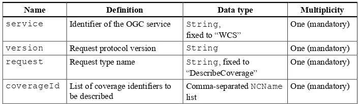
Requirement 6 /req/get-kvp/describeCoverage-request-structure:
The KVP encoding of a DescribeCoverage request shall be as defined in Table 1. Table 1 — DescribeCoverage request URL encoding
Name Definition Data type Multiplicity
service Identifier of the OGC service String, fixed to “WCS”
One (mandatory)
version Request protocol version String One (mandatory)
request Request type name String, fixed to “DescribeCoverage”
One (mandatory)
coverageId List of coverage identifiers to be described
Comma-separated NCName
list
One (mandatory)
Example The following KVP structure requests information about the coverages with identifiers
C0002, C0003, and C0004, resp.:
eox 7/16/12 4:22 PM
Deleted: TBD
eox 7/16/12 4:22 PM
Formatted: Font:Bold, Do not check spelling or grammar
eox 7/4/12 4:47 PM
OGC 09-147r3
4 Copyright © 2013 Open Geospatial Consortium
Greg Buehler 3/26/13 1:41 PM
Formatted: Font:11 pt
Greg Buehler 3/26/13 1:41 PM
Deleted: Copyright © 2013 Open Geospatial Consortium
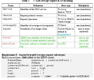
6.4 GetCoverage
Requirement 7 /req/get-kvp/getCoverage-request-structure:
The KVP encoding of a GetCoverage request shall be as defined in Table 2. Table 2 — GetCoverage request KVP encoding
Name Definition Data type Multiplicity
service Identifier of the OGC service String, fixed to “WCS”
one (mandatory)
version Request protocol version String one (mandatory)
request Request type name String, fixed to “GetCoverage”
one (mandatory)
coverageId Identifier of coverage to be inspected NCName one (mandatory)
subset boundaries of coverage subset SubsetSpec as defined in
Requirement 8
zero or more (optional)
format MIME type identifier of the format in which the coverage returned is encoded
anyURI zero or one (optional)
mediaType If present, enforces a multipart encod-ing
anyURI zero or one (optional)
Requirement 8 /req/get-kvp/getCoverage-request-subsetspec: Each SubsetSpec shall adhere to this EBNF syntax:
SubsetSpec: dimension ( intervalOrPoint ) dimension: NCName
intervalOrPoint: interval | point interval: low , high
low: point | *
high: point | *
point: number | " token " // " = double quote = ASCII 0x42 Syntax rules are as follows [2]: underlined tokens represent literals which appear “as is” (“terminal symbols”), other tokens represent sub-expressions to be substituted (“non-terminals”). A vertical bar (“|”) denotes alternatives, items in brackets (“[ ]”) are optional. Non-terminals NCName, number, token, and anyURI follow the resp. XML definitions.
NOTE Allowed values for points are determined by the CRS used. Examples include “2009-11-06” for time, -41.5 and “41°5’ ” for lat/long, and 100 for array coordinates; note that non-numeric values have to be enclosed in double quotes.
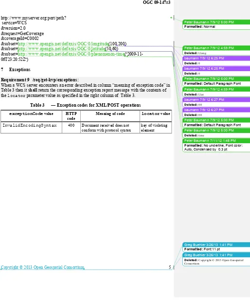
Example The following KVP-encoded GetCoverage request addresses service path on server
OGC 09-147r3
Copyright © 2013 Open Geospatial Consortium 5
Greg Buehler 3/26/13 1:41 PM
Formatted: Font:11 pt
Greg Buehler 3/26/13 1:41 PM
Deleted: Copyright © 2013 Open Geospatial Consortium
&subset=http://www.opengis.net/def/axis/OGC/0/longitude(100,200) &subset=http://www.opengis.net/def/axis/OGC/0/latitude(50,60)
&subset=http://www.opengis.net/def/axis/OGC/0/phenomenon-time(" 2009-11-06T23:20:52Z")
7 Exceptions
Requirement 9 /req/get-kvp/exceptions:
When a WCS server encounters an error described in column “meaning of exception code” in Table 3 then it shall return the corresponding exception report message with the contents of the locator parameter value as specified in the right column of Table 3.
Table 3 — Exception codes for XML/POST operations
exceptionCode value HTTP
code
Meaning of code locator value
InvalidEncodingSyntax 400 Document received does not conform with protocol syntax
key of violating element
Peter Baumann 7/9/12 5:00 PM
Formatted: Normal
Peter Baumann 7/9/12 4:59 PM
Deleted: Llong
baumann 7/9/12 6:25 PM
Deleted: 0
baumann 7/9/12 6:25 PM
Deleted: 0
Peter Baumann 7/9/12 5:00 PM
Formatted: Default Paragraph Font
Peter Baumann 7/9/12 5:00 PM
Formatted: Default Paragraph Font
Peter Baumann 7/9/12 4:59 PM
Deleted: Llat
baumann 7/9/12 6:27 PM
Deleted: 00
baumann 7/9/12 6:27 PM
Deleted: 00
Peter Baumann 7/9/12 5:00 PM
Deleted: time
Peter Baumann 7/11/12 1:48 PM
OGC 09-147r3
6 Copyright © 2013 Open Geospatial Consortium
Greg Buehler 3/26/13 1:41 PM
Formatted: Font:11 pt
Greg Buehler 3/26/13 1:41 PM
Deleted: Copyright © 2013 Open Geospatial Consortium
Bibliography
[1] IETF RFC 2396, Uniform Resource Identifiers (URI): Generic Syntax. IETF, 1998 [2] IETF RFC 2616, Hypertext Transfer Protocol -- HTTP/1.1. IETF, 1999
eox 7/16/12 4:34 PM
Deleted: <#>IETF RFC 2387, The MIME
Multi-part/Related Content-type. IETF, 1998
eox 7/16/12 4:34 PM
Deleted: <#>W3C Note 11, SOAP Messages with
OGC 09-147r3
Copyright © 2013 Open Geospatial Consortium 7
Greg Buehler 3/26/13 1:41 PM
Formatted: Font:11 pt
Greg Buehler 3/26/13 1:41 PM
Deleted: Copyright © 2013 Open Geospatial Consortium
Annex A (normative)
Abstract test suite
A WCS implementing this extension shall pass all of the following tests, plus those of the WCS core [OGC 09-110r3], to be conformant with this specification.
Conformance Test Class: get-kvp
The OGC URI identifier of this conformance class is:
http://www.opengis.net/spec/WCS_protocol-binding_get-kvp/1.0/conf/get-kvp. Test identifiers below are relative to http://www.opengis.net/spec/WCS_protocol-binding_get-kvp/1.0/.
Extension identification
Test id: /conf/get-kvp/extension-identifier
Test Purpose: Requirement /req/get-kvp/extension-identifier:
A WCS service implementing this extension shall include the following URI in the Profile element of the ServiceIdentification in a
GetCapabilities response:
http://www.opengis.net/spec/
WCS_protocol-binding_get-kvp
Test method: Send a GetCapabilities request to server under test, verify that the response contains a Profile element with said URI.
Encode special characters
Test id: /conf/get-kvp/url-encoding
Test Purpose: Requirement /req/get-kvp/url-encoding:
Operation requests shall URL-encode special characters as defined in [1].
Test method: For each request type, send a request to the service under test which con-tains special characters. Check correct handling of the special characters.
Proper case handling
Test id: /conf/get-kvp/case-sensitivity
Test Purpose: Requirement /req/get-kvp/case-sensitivity:
Unknown
Field Code Changed
Peter Baumann 7/9/12 5:10 PM
Deleted: -class/get-kvp
Unknown
Field Code Changed
Greg Buehler 3/26/13 1:18 PM
Deleted: /req/get-kvp/extension-identifier:
A WCS service implementing this extension shall include the following URI in the Profile element of the ServiceIdentification in a GetCapa-bilities response:
http://www.opengis.net/spec/ WCS_protocol-binding_get-kvp/req/get-kvp/extension-identifier:
A WCS service implementing this extension shall include the following URI in the Profile element of the ServiceIdentification in a GetCapa-bilities response:
http://www.opengis.net/spec/ WCS_protocol-binding_get-kvp
Greg Buehler 3/26/13 1:18 PM
Deleted: /req/get-kvp/url-encoding: Operation requests shall URL-encode special char-acters as defined in [1]./req/get-kvp/url-encoding:
Operation requests shall URL-encode special char-acters as defined in [2]./req/get-kvp/url-encoding:
Operation responses shall URL-encode special characters as defined in [2].
Peter Baumann 7/9/12 5:05 PM
OGC 09-147r3
8 Copyright © 2013 Open Geospatial Consortium
Greg Buehler 3/26/13 1:41 PM
Formatted: Font:11 pt
Greg Buehler 3/26/13 1:41 PM
Deleted: Copyright © 2013 Open Geospatial Consortium
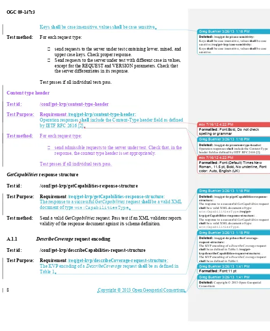
Keys shall be case insensitive, values shall be case sensitive.
Test method: For each request type:
send requests to the server under test containing lower, mixed, and upper case keys. Check proper response.
Send requests to the server under test with different case in values, except for the REQUEST and VERSION parameters. Check that the server differentiates in its response.
Test passes if all individual tests pass. Content type header
Test id: /conf/get-kvp/content-type-header
Test Purpose: Requirement /req/get-kvp/content-type-header:
Operation responses shall include the Content-Type header field as defined by IETF RFC 2616 [2].
Test method: For each request type:
send admissible requests to the server under test. Check that, in the response, the content type header is set appropriately.
Test passes if all individual tests pass.
GetCapabilities response structure
Test id: /conf/get-kvp/getCapabilities-response-structure
Test Purpose: Requirement /req/get-kvp/getCapabilities-response-structure: The response to a successful GetCapabilities request shall be a valid XML document of type wcs:CapabilitiesType.
Test method: Send a valid GetCapabilities request. Pass test if an XML validator reports validity of the response document against its schema definition.
A.1.1 DescribeCoverage request encoding
Test id: /conf/get-kvp/describeCapabilities-request-structure
Test Purpose: Requirement /req/get-kvp/describeCoverage-request-structure: The KVP encoding of a DescribeCoverage request shall be as defined in Table 1.
Greg Buehler 3/26/13 1:18 PM
Deleted: /req/get-kvp/case-sensitivity:
Keys shall be case insensitive, values shall be case sensitive./req/get-kvp/case-sensitivity:
Keys shall be case insensitive, values shall be case sensitive.
eox 7/16/12 4:22 PM
Formatted: Font:Bold, Do not check spelling or grammar
Greg Buehler 3/26/13 1:18 PM
Deleted: /req/get-kvp/content-type-header: Operation responses shall include the Content-Type header field as defined by IETF RFC 2616 [2].
eox 7/16/12 4:22 PM
Formatted: Font:(Default) Times New Roman, 11.5 pt, Bold, No underline, Font color: Auto, English (UK)
Greg Buehler 3/26/13 1:18 PM
Deleted:
/req/get-kvp/getCapabilities-response-structure:
The response to a successful GetCapabilities request
shall be a valid XML document of type
wcs:CapabilitiesType. /req/get-kvp/getCapabilities-response-structure:
The response to a successful GetCapabilities request
shall be a valid XML document of type
wcs:CapabilitiesType.
Greg Buehler 3/26/13 1:18 PM
Deleted:
/req/get-kvp/describeCoverage-request-structure:
The KVP encoding of a DescribeCoverage request
shall be as defined in Table 1. /req/get-kvp/describeCapabilities-request-structure:
The KVP encoding of a DescribeCoverage request
OGC 09-147r3
Copyright © 2013 Open Geospatial Consortium 9
Greg Buehler 3/26/13 1:41 PM
Formatted: Font:11 pt
Greg Buehler 3/26/13 1:41 PM
Deleted: Copyright © 2013 Open Geospatial Consortium
Test method: Send DescribeCoverage requests testing server response on the cases dis-tinguished in said reference. Check proper response.
A.1.2 GetCoverage request encoding
Test id: /conf/get-kvp/getCoverage-request-structure
Test Purpose: Requirement /req/get-kvp/getCoverage-request-structure:
The KVP encoding of a GetCoverage request shall be as defined in Table 2.
Test method: Send GetCoverage requests testing server response on the cases distin-guished in said reference. Check proper response.
A.1.3 GetCoverage subset specification
Test id: /conf/get-kvp/getCoverage-request-subsetspec
Test Purpose: Requirement /req/get-kvp/getCoverage-request-subsetspec: Each SubsetSpec shall adhere to this EBNF syntax:
SubsetSpec: dimension ( intervalOrPoint )
dimension: NCName
intervalOrPoint: interval | point
interval: low , high
low: point | *
high: point | *
point: number | " token " // " = double quote = ASCII 0x42
Test method: Send GetCoverage requests to the service under test, evaluate whether re-sponses are adequate. Exercise tests for each of the following situations for each coverage dimensionality supported by the server:
No subsetting parameter
One or more trimmings, no slicing One or more slicings, no trimming
trim operations with trim coordinates and with “*” for low and high bound (independently)
Pass if coverage responses indicate (by range set inspection) that the opera-tion has been recognized and executed properly.
Greg Buehler 3/26/13 1:18 PM
Deleted: /req/get-kvp/getCoverage-request-structure:
The KVP encoding of a GetCoverage request shall
be as defined in Table 2. /req/get-kvp/getCoverage-request-structure:
The KVP encoding of a GetCoverage request shall
be as defined in Table 2.
Greg Buehler 3/26/13 1:18 PM
Deleted:
/req/get-kvp/getCoverage-request-subsetspec:
Each SubsetSpecshall adhere to this EBNF syntax:
SubsetSpec: dimension ( intervalOrPoint )
dimension: NCName
intervalOrPoint: interval | point interval: low , high
low: point | * high: point | *
point: number | " token " // " = double quote = ASCII 0x42 /req/get-kvp/getCoverage-request-subsetspec:
Each SubsetSpecshall adhere to this EBNF syntax:
SubsetSpec: dimension ( intervalOrPoint )
dimension: NCName
intervalOrPoint: interval | point interval: low , high
low: point | * high: point | *
OGC 09-147r3
10 Copyright © 2013 Open Geospatial Consortium
Greg Buehler 3/26/13 1:41 PM
Formatted: Font:11 pt
Greg Buehler 3/26/13 1:41 PM
Deleted: Copyright © 2013 Open Geospatial Consortium
A.1.4 Exceptions
Test id: /conf/get-kvp/exceptions
Test Purpose: Requirement /req/get-kvp/exceptions:
When a WCS server encounters an error described in column “meaning of exception code” in Table 3 then it shall return the corresponding exception report message with the contents of the locator parameter value as speci-fied in the right column of Table 3.
Test method: Send requests of all types supported to the server under test. Each request shall include all (mandatory and) optional parameters and shall be valid except for one parameter which shall contain an encoding error described in the exception specification. Test passes if exception is reported according to requirement.
-- end of ATS --
Greg Buehler 3/26/13 1:18 PM
Deleted: /req/get-kvp/exceptions:
When a WCS server encounters an error described in column “meaning of exception code” in Table 3 then it shall return the corresponding exception report message with the contents of the locator parame-ter value as specified in the right column of Table 3./req/get-kvp/exceptions: