Date: 2009-03-25
Reference number of this OGC® Project Document: OGC 08-068r2 Version:1.0.0
Category: OpenGIS® Interface Standard Editor: Peter Baumann
Web Coverage Processing Service (WCPS) Language
Interface Standard
Copyright © 2009 Open Geospatial Consortium, Inc. All Rights Reserved. To obtain additional rights of use, visit http://www.opengeospatial.org/legal/.
Document type: OpenGIS® Interface Standard Document subtype: Extension Package
License Agreement
Permission is hereby granted by the Open Geospatial Consortium, ("Licensor"), free of charge and subject to the terms set forth below, to any person obtaining a copy of this Intellectual Property and any associated documentation, to deal in the Intellectual Property without restriction (except as set forth below), including without limitation the rights to implement, use, copy, modify, merge, publish, distribute, and/or sublicense copies of the Intellectual Property, and to permit persons to whom the Intellectual Property is furnished to do so, provided that all copyright notices on the intellectual property are retained intact and that each person to whom the Intellectual Property is furnished agrees to the terms of this Agreement.
If you modify the Intellectual Property, all copies of the modified Intellectual Property must include, in addition to the above copyright notice, a notice that the Intellectual Property includes modifications that have not been approved or adopted by LICENSOR. THIS LICENSE IS A COPYRIGHT LICENSE ONLY, AND DOES NOT CONVEY ANY RIGHTS UNDER ANY PATENTS THAT MAY BE IN FORCE ANYWHERE IN THE WORLD.
THE INTELLECTUAL PROPERTY IS PROVIDED "AS IS", WITHOUT WARRANTY OF ANY KIND, EXPRESS OR IMPLIED, INCLUDING BUT NOT LIMITED TO THE WARRANTIES OF MERCHANTABILITY, FITNESS FOR A PARTICULAR PURPOSE, AND NONINFRINGEMENT OF THIRD PARTY RIGHTS. THE COPYRIGHT HOLDER OR HOLDERS INCLUDED IN THIS NOTICE DO NOT WARRANT THAT THE FUNCTIONS CONTAINED IN THE INTELLECTUAL PROPERTY WILL MEET YOUR REQUIREMENTS OR THAT THE OPERATION OF THE INTELLECTUAL PROPERTY WILL BE UNINTERRUPTED OR ERROR FREE. ANY USE OF THE INTELLECTUAL PROPERTY SHALL BE MADE ENTIRELY AT THE USER’S OWN RISK. IN NO EVENT SHALL THE COPYRIGHT HOLDER OR ANY CONTRIBUTOR OF INTELLECTUAL PROPERTY RIGHTS TO THE INTELLECTUAL PROPERTY BE LIABLE FOR ANY CLAIM, OR ANY DIRECT, SPECIAL, INDIRECT OR CONSEQUENTIAL DAMAGES, OR ANY DAMAGES WHATSOEVER RESULTING FROM ANY ALLEGED INFRINGEMENT OR ANY LOSS OF USE, DATA OR PROFITS, WHETHER IN AN ACTION OF CONTRACT, NEGLIGENCE OR UNDER ANY OTHER LEGAL THEORY, ARISING OUT OF OR IN CONNECTION WITH THE IMPLEMENTATION, USE, COMMERCIALIZATION OR PERFORMANCE OF THIS INTELLECTUAL PROPERTY. This license is effective until terminated. You may terminate it at any time by destroying the Intellectual Property together with all copies in any form. The license will also terminate if you fail to comply with any term or condition of this Agreement. Except as provided in the following sentence, no such termination of this license shall require the termination of any third party end-user sublicense to the Intellectual Property which is in force as of the date of notice of such termination. In addition, should the Intellectual Property, or the operation of the Intellectual Property, infringe, or in LICENSOR’s sole opinion be likely to infringe, any patent, copyright, trademark or other right of a third party, you agree that LICENSOR, in its sole discretion, may terminate this license without any compensation or liability to you, your licensees or any other party. You agree upon termination of any kind to destroy or cause to be destroyed the Intellectual Property together with all copies in any form, whether held by you or by any third party. Except as contained in this notice, the name of LICENSOR or of any other holder of a copyright in all or part of the Intellectual Property shall not be used in advertising or otherwise to promote the sale, use or other dealings in this Intellectual Property without prior written authorization of LICENSOR or such copyright holder. LICENSOR is and shall at all times be the sole entity that may authorize you or any third party to use certification marks, trademarks or other special designations to indicate compliance with any LICENSOR standards or specifications.
This Agreement is governed by the laws of the Commonwealth of Massachusetts. The application to this Agreement of the United Nations Convention on Contracts for the International Sale of Goods is hereby expressly excluded. In the event any provision of this Agreement shall be deemed unenforceable, void or invalid, such provision shall be modified so as to make it valid and enforceable, and as so modified the entire Agreement shall remain in full force and effect. No decision, action or inaction by LICENSOR shall be construed to be a waiver of any rights or remedies available to it.
OGC official documents use a triple decimal-dot notation (i.e. MM.xx.ss). This document may be identified as MM.xx (Major.minor) and may include increments to the third dot series (schema changes) without any modification to this document, or the version dis-played on the document. This means, for example, that a document labelled with versions 1.1.0 and 1.1.1 or even 1.1.9 are exactly the same except for modifications to the official schemas that are maintained and perpetually located at: http://schemas.opengis.net/. Note that corrections to the document are registered via corrigendums. A corrigendum will change the base document and notice will be given by appending a c# to the version (where # specifies the corrigendum number). In corrigendums that correct both the sche-mas and the base document, the third triplet of the document version will increment and the ‘c1’ or subsequent identifier will be appended, however the schemas will only in-crease the third triplet of the version.
1 Scope ... Error! Bookmark not defined. 2 Compliance ... Error! Bookmark not defined. 3 Normative references ... Error! Bookmark not defined. 4 Terms and definitions ... Error! Bookmark not defined.
5.1 Symbols (and abbreviated terms) ... 2
5.2 UML notation ... 2
5.3 Platform-neutral and platform-specific specifications ... 2
6.1 Coverage model ... 3
6.1.6 Null and interpolation... 6
6.2 Coverage probing functions summary ... 6
6.3 Restrictions relative to the WCS coverage model ... 8
7.1.26 sliceExpr ... 38
7.1.27 scaleExpr ... 40
7.1.28 crsTransformExpr ... 42
7.1.29 coverageConstructorExpr ... 44
7.1.30 coverageConstantExpr ... 46
7.1.31 condenseExpr ... 49
7.1.32 generalCondenseExpr ... 49
7.1.33 reduceExpr ... 51
7.2 Expression evaluation ... 52
7.2.1 Evaluation sequence ... 52
7.2.2 Nesting ... 52
7.2.3 Parentheses ... 52
7.2.4 Operator precedence rules ... 53
7.2.5 Range type compatibility and extension ... 53
7.3 Evaluation exceptions ... 55
7.4 processCoveragesExpr response ... 55
Tables
Page Table 1 – Coverage domain dimension types. ... 3Table 2 – Coverage range field data types. ... 6
Table 3 – Coverage probing functions. ... 6
Table 4 – reduceExpr definition via generalCondenseExpr ... 51
i. Preface
The OGC® Web Coverage Processing Service (WCPS) defines a protocol-independent language for the extraction, processing, and analysis of multi-dimensional coverages representing sensor, image, or statistics data.
Suggested additions, changes, and comments on this standard are welcome and encour-aged. Such suggestions may be submitted by email message or by making suggested changes in an edited copy of this document.
ii. Submitting organizations
The following organizations have submitted this Interface Standard to the Open Geospa-tial Consortium, Inc.
Jacobs University Bremen
iii. Document Contributor Contact Points
Name Organization Peter Baumann Jacobs University Bremen,
rasdaman GmbH
iv. Revision history
Date Release Author Paragraph modified Description 2008-04-29 0.0.1 Peter Baumann created from 07-151r1 and 08-059r3 2008-09-01 0.0.2 Peter Baumann Many Final version following adoption 2008-09-22 0.0.3 Peter Baumann Result type specs More accurate phrasing, not just table
reference
2009-01-08 1.0.0 Peter Baumann many Reworked scalar operations; incorporated e-vote comments; fixed syntax inconsis-tencies; final editorial brush-up
v. Changes to the OpenGIS
®Abstract Specification
vi. Future Work
This WCPS framework will be enhanced and extended incuding the following features:
1) WCPS is based on the conceptual model of OGC WCS and OGC Abstract Topic 6. As the revision of WCS and Abstract Topic 6 proceeds, WCPS will have to be adapted to maintain coherence.
2) In particular, the GeneralDomain is making its way into WCS 1.2; once this is ac-cepted, WCPS has to be adapted to the agreed shape and usage of GeneralDo-main.
3) Add support for further coverage types beyond equidistant grids.
4) Add support for inserting, updating, and deleting coverages through expressions (harmonized with WCS-T).
5) Refine metadata probing functions.
6) Extend metadata querying functionality to non-primitive data structure elements.
Foreword
The WCPS language standard evolved from an earlier Best Practice Paper [OGC 07-157r1], and supersedes that document. This document does not supersede any other pre-viously approved OGC document.
This document includes two normative Annexes, A and B.
Attention is drawn to the possibility that some of the elements of this document may be the subject of patent rights. The Open Geospatial Consortium Inc. shall not be held re-sponsible for identifying any or all such patent rights.
Introduction
The OGC Web Coverage Processing Service (WCPS) defines a language for retrieval and processing of multi-dimensional geospatial coverages representing sensor, image, or sta-tistics data. Services implementing this language provide access to original or derived sets of geospatial coverage information, in forms that are useful for client-side rendering, input into scientific models, and other client applications.
WCPS relies on the coverage model as defined in OGC Abstract Specification Topic 6 “Schema for Coverage Geometry and Functions “ [OGC 07-011] and the OGC Web Cover-age Service (WCS) Standard [OGC 07-067r5] where coverCover-ages are defined as “digital geospatial information representing space-varying phenomena”, currently constrained to equally spaced grids.
The WCPS language is independent from any particular request and response encoding, as no concrete request/response protocol is specified by WCPS. For setting up a WCPS instance, therefore, a separate, additional specification establishing the concrete protocol is required. This allows embedding of WCPS into different target service frameworks.
One such target framework is OGC WCS. Together with the pertaining request type defi-nition [OGC 08-059r3] WCPS forms an extension of the Web Coverage Service (WCS) version 1.1.2 Standard [OGC 07-067r5]. With small changes, this extension is expected to also apply to subsequent versions of WCS.
Open Geospatial Consortium
Interface:
Web Coverage Processing Service (WCPS)
1 Scope
This document defines a protocol-independent language for retrieving and processing geospatial coverage data.
Like WCS, WCPS is currently limited to quadrilateral grid coverages, providing informa-tion at the grid points, usually with interpolainforma-tion between these grid points.
NOTE For future versions of this standard it is intended to extend WCPS to incorporate further cover-age types defined in the OGC Abstract Specification Topic 6 “Schema for Covercover-age Geometry and Func-tions" [OGC document 07-011, in synchronization with WCS.
2 Compliance
Annex A (normative) specifies compliance tests which shall be tested by any service claiming to implement WCPS.
3 Normative references
The following normative documents contain provisions that, through reference in this text, constitute provisions of this standard. For dated references, subsequent amendments to, or revisions of, any of these publications do not apply. For undated references, the lat-est edition of the normative document referred to applies.
IETF RFC 2616, Hypertext Transfer Protocol -- HTTP/1.1
ISO 8601:2000, Data elements and interchange formats — Information interchange —
Representation of dates and times
OGC 05-007r7, Web Processing Service Implementation Standard, version 1.0.0
OGC 06-121r3, OpenGIS® Web Services Common Standard, version 1.1.0
NOTE This OWS Common Standard contains a list of normative references that are also applicable to this Interface Standard.
OGC 07-067r5, OpenGIS® Web Coverage Service Implementation Standard, version
1.1.2
NOTE The WCS standard cited contains a list of normative references that are also applicable to this extension standard.
OGC 07-092r1, Definition identifier URNs in OGC namespace, version 1.1.2
OGC 08-053r2, WCS Processing Extension Abstract Test Suite, version 1.0.0
OGC 08-059r3, WCS Processing Extension, version 1.0.0
4 Terms and definitions
For the purposes of this document, the terms and definitions given in the above refer-ences (in particular: WCS [OGC 07-067r5]) apply.
5 Conventions
5.1 Symbols (and abbreviated terms)
Most of the abbreviated terms listed in Subclause 5.1 of the OWS Common Standard [OGC 06-121r3] also apply to this document.
Further, this document assumes familiarity with the terms and concepts of the Web Coverage Service Standard [OGC 07-067r5].
5.2 UML notation
All the diagrams that appear in this standard are presented using the Unified Modeling Lan-guage (UML) static structure diagram, as described in Subclause 5.2 of the OGC Web Ser-vices Common Standard [OGC 06-121r3].
5.3 Platform-neutral and platform-specific specifications
In terms of Clause 10 of OGC Abstract Specification Topic 12 “OpenGIS Service Archi-tecture” (which contains ISO 19119), this document includes only Distributed Comput-ing Platform-neutral specifications. This document specifies each operation request and response in platform-neutral fashion. This is done using a semi-formal approach to recur-sively specifying the language syntax and semantics. To assist this, the coverage model is formalized as well (but not changed over WCS OGC 07-067r5]).
6 Conceptual coverage model
The coverage model of WCPS relies on the coverage model of WCS [OGC 07-067r5] and formalizes it in a way which is suitable for expressing the semantics of the operations in Section 7.1. Subclause 6.2 describes the constituents of a WCPS coverage by defining a set of coverage probing functions. Some restrictions that apply with regard to general WCS coverages are listed in Section 6.3.
NOTE The coverage model specified in this section serves as an interim substitute for a more forma-lized overall WCS coverage model; once said model is in place it will replace this section.
6.1 Coverage model
6.1.1 Coverages
A coverage consists of a set of locations bearing some value. Following the mathematical notion of a function that maps elements of a domain (here: spatio-temporal1 coordinates)
to a range (here: “pixel”, “voxel”, … values), the set of coverage locations bearing values is called the coverage domain while the set of possible values, i.e., the coverage value data type, is called the coverage range.
A coverage domain with its set of locations (or coordinates) is aligned along some d -dimensional grid where d>0 is called the coverage’s dimensionality. The coordinate space, i.e. the set of all possible coordinates, is spanned by d independent dimension axes. A dimension axis (abbreviated also as dimension or as axis) is identified by its name which is unique within the coverage. The set of all dimension axis names of a cov-erage C is obtained via the function dimensionNameSet(C).
6.1.2 Dimensions
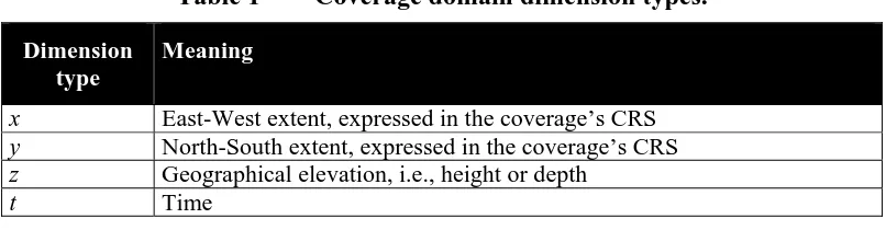
Each dimension has an dimension type associated, which is one of the elements listed in Table 1. A coverage can have at most one x, y, z, and t dimension.
Table 1 – Coverage domain dimension types.
Dimension type
Meaning
x East-West extent, expressed in the coverage’s CRS y North-South extent, expressed in the coverage’s CRS z Geographical elevation, i.e., height or depth
t Time
collectively termed the Image CRS). Any number of further CRSs can be associated with a coverage dimension, given by the set crsSet(C,a). Image CRS and further CRSs togeth-er dettogeth-ermine the set of CRSs which can be used in coordinate-aware optogeth-erations. Time coordinates coordinates shall be expressed as strings adhering to [ISO 8601:2000]. NOTE An image CRS always allows to address a coverage in all dimensions. For the other CRSs, however, several CRSs together may be necessary to fully address a coverage – for example, WGS84 only knows x and y and thus does not allow to specify z and t coordinates in a 4-D x/y/z/t climate model. The WCPS service does not need to publish the mapping between coordinates of the dif-ferent supported CRSs.
6.1.3 Locations
A location L is a set
LC = { (a,c,p) | a∈dimensionNameSet(C), c∈crsSet(C), p∈DimensionPointValues } consisting of dimension names, per dimension the coordinate system used, and a coordi-nate relative to this dimension and CRS; each of the coverage’s dimension name shall appear exactly once in this set. The set DimensionPointValues is a generalization of nu-meric and string values that allows to express all kind of coordinates, including geo-graphic floating-point coordinates and date/time strings.
Example For dimension type t, encoding follows [ISO 8601:2000] as described in WCS [OGC 07-067r5] Table 16, 17 and owsTime (that is, the possible values are ASCII strings). For an image CRS, en-coding will be integer for all dimension types, and for x/y type geographic coordinates it will usually be float.
On each dimension a total ordering relation “≤” shall be available under all CRSs used.
Example On a t dimension, this ordering relation will yield true for the following comparison: “Sun Jan 1 23:59:59 CET 2006”
≤ “Tue Dec 5 22:17:48 CET 2006”
Along each dimension a coverage is delimited by a lower and upper bound value, these border values being part of the coverage extent. Location addresses always are relative to a particular coverage.
6.1.4 Domain
The set of all locations contained in a coverage forms its domain. A domain’s location set always is non-empty. It can be described, for each dimension, by a lower and upper bound (lo,hi) expressed in one of the coverage’s CRSs applicable for this dimension where lo≤hi.
domain( C ) = { (a,t,c,lo,hi) | a∈dimensionNameSet(C), t∈{x,y,z,time}, c∈crsSet(C), lo,hi∈DimensionPointValues, lo≤hi }
A location L is inside the domain of a coverage C if its coordinates are inside the domain extent under all CRSs supported:
Let
C be a coverage,
LC be a location wrt. coverage C
with LC = { (a,c,p) | a∈dimensionNameSet(C), c∈crsSet(C), p∈DimensionPointValues },
GC be the domain of coverage C
with GC = { (a,t,c,lo,hi) | a∈dimensionNameSet(C), t∈{x,y,z,time}, c∈crsSet(C), lo,hi∈DimensionPointValues, lo≤hi }.
Then,
LC inside GC if and only if
for all (a,c,p)∈LC there is some lo,hi∈DimensionPointValues such that: (a,t,c,lo,hi)∈GC and lo≤p≤hi relative to CRS c
6.1.5 Range values and types
The value associated with a particular location within a coverage, in short: its point val-ue, can be obtained with probing function value(C,lC) which is defined for every location lC ∈imageCrsDomain(C) and lC inside domain(C).
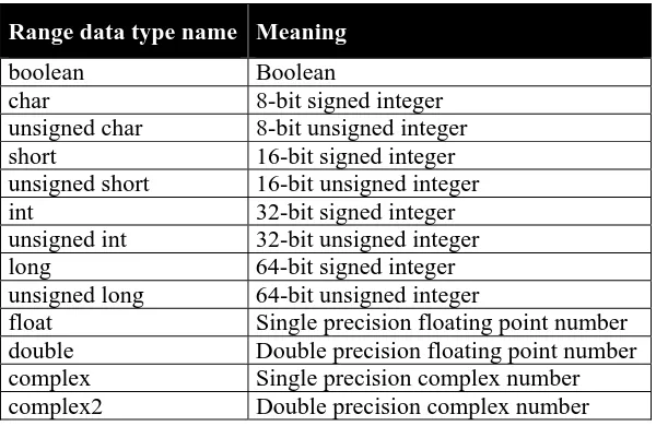
All grid point values of a coverage share the same type, the coverage’s range type. Ad-missible types consist of named components called fields; each field is identified by a field name unique for the coverage on hand and bears one of the (atomic) numeric or Boolean types enumerated in the set RangeFieldTypes (see Table 2):
RangeFieldTypes = { boolean, char, unsigned char, short, unsigned short, int, un-signed int, long, unun-signed long, float, double, complex, complex2 }
NOTE 1 This is a restriction over WCS [OGC 07-067r5], see Subclause 6.3.
NOTE 2 It is not required that all range fields within a coverage are of the same type. NOTE 3 Range fields are also known as “bands” or “channels”.
A coverage’s range type description can be obtained by function rangeType() which de-livers a set of pairs of field names and field type:
Table 2 – Coverage range field data types.
Range data type name Meaning
boolean Boolean char 8-bit signed integer unsigned char 8-bit unsigned integer short 16-bit signed integer unsigned short 16-bit unsigned integer int 32-bit signed integer unsigned int 32-bit unsigned integer long 64-bit signed integer unsigned long 64-bit unsigned integer
float Single precision floating point number double Double precision floating point number complex Single precision complex number complex2 Double precision complex number
6.1.6 Null and interpolation
The set of a coverage’s values to be interpreted as null is obtained via probing function nullSet(). This set can be empty.
Probing function interpolationSet(C) returns a set of pairs (im,nr) where im indicates the interpolation type and nr the null resistance employed. This set can be empty.
Interpolation method defaults associated with a coverage can be obtained through prob-ing function interpolationDefault().
6.2 Coverage probing functions summary
A set of so-called probing functions allows to extract the constituents listed above from a given coverage. These functions are not part of the WCPS interface standard, but serve for the sole purpose of defining the semantics of ProcessCoverages requests in Clause 7.1.
Table 3 lists the probing functions provided.
For notational convenience in this document, on the list and set valued items the usual list and set functions are assumed for extraction and manipulation, such as union,
inter-section. Further, application of some function to a list or set which is defined on the ele-ments denotes simultaneous application of this function to all list or set eleele-ments.
Table 3 – Coverage probing functions.
Coverage characteristic
Probing function for some coverage C
Comment
processed coverage results Grid point values value(C,p )
for all p∈ imageCrsDomain(C )
The coverage grid point (“pixel”), “voxel”, …) values, of data type ran-geType(C )
Domain dimension list
dimensionList(C ) List of all of the coverage’s dimension names, in their proper sequence
imageCrsDomain(C ) Extent of the coverage in (integer) grid coordinates, relative to the coverage’s Image CRS2; essentially, the set of all
point coordinates inside the coverage
Extent of the coverage in (integer) grid coordinates, relative to the coverage’s Image CRS, for a given dimension; essentially, the set of all values inside the extent interval
CRS set crsSet(C, a )
for some a∈ dimensionList(C )
Set of all CRSs from the supported CRS (see [OGC 07-067r5]
Describe-domain of the coverage, expressed in one of its CRSs, for a given (spatial, or temporal) dimension
Range data type rangeType(C ) The data type of the coverage’s grid point values, given as a set of pairs of field Name and (atomic) data type Range field type rangeFieldType(C, f )
for some f∈rangeFieldNames(C)
The data type of one coverage range field, given as some atomic type name Range field name set rangeFieldNames(C ) Set all of the coverage’s range fields
names Null value set nullSet(C,r )
for all r∈ rangeType(C )
The set of all values that represent null as coverage range field value must list at least the default inter-polation method
Interpolation type interpolationType(im )
for all im∈ interpolationList(C)
Interpolation type of a particular inter-polation method; possible values are listed in WCS [OGC 07-067r5] Table I.7
Null resistance nullResistance(im )
for all im∈ interpolationList(C)
Null resistance level of a particular interpolation methods; possible values are listed in WCS [OGC 07-067r5] Table I.8
Example For a set of numbers {-1, 0, 1} the abs() function produces: abs( {-1, 0, 1} ) = { abs(-1), abs(0), abs(1) } = { 0, 1 } …while for a list (-1, 0, 1) the abs() function produces:
abs( (-1, 0, 1) ) = ( abs(-1), abs(0), abs(1) ) = ( 1, 0, 1 )
NOTE Operations in WCPS rely solely on the structural information when performing semantic checks, i.e., on structural compatibility in operations. Ensuring semantic interoperability of coverage do-mains and ranges is not within the current scope of WCPS.
6.3 Restrictions relative to the WCS coverage model
The following WCS coverage features are not supported by this version of WCPS:
- Range field types in WCPS are constrained to the set indicated in Table 2 whereas WCS allows any kind of data structure for range fields.
NOTE 1 This is necessary to concisely fix the semantics of operations on the range types. NOTE 2 In practice this should hardly pose a restriction, as at least all numeric types occurring in the applications perceived are provided.
- Range field components in WCPS are atomic.
NOTE This is believed to cover most practical cases, and allows to emulate the remaining cas-es.
7 WCPS coverage processing language
The WCPS coverage processing language allows WCPS clients to request processing of one or more coverages available on a WCPS server. A WCPS server evaluates an expression and returns an appropriate response to the client. The result returned to the client upon a successful request consists of an ordered sequence of one or more coverag-es or scalar valucoverag-es.
A WCPS processing request consists of a processCoveragesExpr (see Subclause 7.1.1). Each WCPS server shall implement the coverage processing operation as specified in the following subclauses.
NOTE 1 While the WCS GetCoverage operation allows retrieval of a coverage from a coverage offering, possibly modified through operations like spatial, temporal, and band subsetting and coordinate transformation, the WCPS language extends this functionality through more powerful processing
capabilities. This includes, on the one hand, further coverage processing primitives and, on the other hand, nesting of function application, thereby allowing for arbitrarily complex requests.
the service permanently unavailable. Notwithstanding, it still is possible to send requests that will impose high workload on a server.
NOTE 3 Data items within a WCPS response list can be heterogeneous in size and structure. In particu-lar, the coverages within a response list can have different dimensions, domains, range types, etc. Howev-er, a response always consists of either coverages or scalar values.
NOTE 4 As the functionality of WCPS centers around coverage processing, metadata are considered only to the extent necessary for a coherent service. This way WCPS keeps orthogonal to other OGC stan-dards.
7.1 Expression syntax
The WCPS primitives plus the nesting capabilities form an expression language, which is independent from any particular encoding, and collectively is referred to as WCPS lan-guage. In the following subsections the language elements are detailed. The complete syntax is listed in Appendix B.
A WCPS expression is called admissible if and only if it adheres to the WCPS language definition. WCPS servers shall return an exception in response to a WCPS request that is not admissible.
Example The coverage expression C * 2
is admissible as it adheres to WCPS syntax whereas C C
seen as a coverage expression violates WCPS syntax and, hence, is not admissible.
The semantics of a WCPS expression is defined by indicating, for all admissible expres-sions, the value of each coverage constituent as defined in Subclause 6.2.
An expression is valid if and only if it is admissible and it complies with the conditions imposed by the WCPS language semantics.
Example The coverage expression following is valid if and only if the WCPS offers a coverage with identifier C that has a numeric field named red.
C.red * 2.5
NOTE In the remainder of this section, tables are used to describe the effect of an operation on each coverage constitutent. For the reader’s convenience an extra column “Changed?” is provided containing an “X” character whenever the operation changes the resp. constituent, and left blank whenever the operation does not affect the resp. constituent.
7.1.1 processCoveragesExpr
Each coverage is optionally checked first for fulfilling some predicate, and gets selected – i.e., contributes to an element of the result list – only if the predicate evaluates to true. Each coverage selected will be processed, and the result will be appended to the result list. This result list, finally, is returned as the ProcessCoverages response unless no ex-ception was generated.
Let
v1, … vn be n pairwise different iteratorVars (n≥1), L1, … Ln be n coverageLists (n≥1),
b be a booleanScalarExpr possibly containing occurrences of one or more vi (1≤i≤n),
P be a processingExpr possibly containing occurrences of vi (1≤i≤n).
Then,
for any processCoveragesExpr E, where
E = for v1 in ( L1 ), v2 in ( L2 ),
… ,
vn in ( Ln )
where b
return P
the result R of evaluating processCoverageExpr E is constructed as follows:
Let R be the empty sequence; while L1 is not empty:
{ assign the first element in L1 to v1; while L2 is not empty:
{ assign the first element in L2 to v2; …
while Ln is not empty:
{ assign the first element in Ln to vn;
evaluate b and P, substituting any occurrence
of coverage identifier vi by the corresponding coverage; if (b)
then
append evaluation result to R; remove the first element from Ln;
} … }
remove the first element from L1; }
The elements contained in the coverageList clause, constituting coverage identifiers, are taken from the coverage identifiers advertised by the server.
NOTE In a WCS framework such information can be obtained via a GetCapabilities request.
Coverage identifiers may occur more than once in a coverageList. In this case the cover-age shall be inspected each time it is listed, respecting the overall inspection sequence.
Example Assume a WCPS server offers coverages A, B, and C. Then, the server may execute the fol-lowing WCPS request:
for $c in ( A, B, C ) return tiff( $c )
to produce a result list containing three TIFF-encoded coverages tiff(A), tiff(B), tiff(C).
Example Assume a WCPS server offers satellite images A, B, and C and a coverage M acting as a mask (i.e., with range values between 0 and 1). Then, masking each satellite image can be performed with a re-quest like the following:
for $s in ( A, B, C ), $m in ( M )
return tiff( $s * $m )
7.1.2 processingExpr
The processingExpr element is either a encodedCoverageExpr (which evaluates to an encoded coverage; see Subclause 7.1.4), or a storeCoverageExpr (see Subclause 7.1.3), or a scalarExpr (which evaluates to coverage description data or coverage summary da-ta; see Subclause 7.1.5).
7.1.3 storeCoverageExpr
The storeCoverageExpr element specifies that an encoded coverage result as described by its E sub element is not to be delivered immediately as response to the request, but to be stored on server side for subsequent retrieval. The result of the storeCoverageExpr expression is the URL under which the result is provided by the server, and the server returns only the XML response part with the URL(s) being in place of the coverage(s) generated.
Let
E be an encodedCoverageExpr.
for any URI U where
U = store ( E )
U is defined as that URI at which the coverage result is made available by the server.
Example The following expression will deliver the URL under which the server stores the TIFF-encoded result coverage C:
store( encode( C, “TIFF” ) )
NOTE It is not specified in this standard for how long server-side stored coverages remain available; usually they will be deleted after some implementation dependent time to free server space. Future versions of this standard may offer means to address this.
7.1.4 encodedCoverageExpr
The encodedCoverageExpr element specifies encoding of a coverage-valued request result by means of a data format and possible extra encoding parameters.
Data format encodings should, to the largest extent possible, materialise the coverage’s metadata. A service may store further information as part of the encoding.
Example For a georeferenced coverage, a GeoTIFF result file should contain the coverage’s geo coordi-nate and resolution information.
NOTE For materialization of the coverage grid values, the coverage’s image CRS shall be used by default. See crsTransformExpr (Subclause 7.1.28) for controlling coverage grid values via other CRSs. Let
C be a coverageExpr, f be a string,
where
f is the name of a data format allowed for C,
the data format specified by f supports encoding of a coverage of C’s do-main and range.
Then,
for any byteString S where S is one of
Se = encode ( C,f )
See = encode ( C,f, extraParams )
with extraParams being a string enclosed in double quotes (‘”’)
NOTE 1 In a WCS framework, the data encoding formats supported can be obtained from the suppor-tedFormats list contained in the response a GetCapabilities request.
NOTE 2 Some format encodings may lead to a loss of information. NOTE 3 The extraParams are data format and implementation dependent.
Example The following expression specifies retrieval of coverage C encoded in HDF-EOS: encode( C, ”hdf-eos” )
Example A WCPS implementation may encode a JPEG quality factor of 50% as the string “.50”. Usage of formats shall adhere to the regulations set forth in OGC 07-067r5 Subclause 9.3.2.2. The sequence of axes used for linearizing arrays for encoding shall be done as governed by some corresponding data format encoding specification.
Example A data format may specify that x and y axes are linearized to achieve a row-major ordering of coverage cells.
7.1.5 scalarExpr
The scalarExpr element is either a getMetaDataExpr (see Subclause 7.1.10) or a con-denseExpr (see Subclause 7.1.31) or a booleanScalarExpr (see Subclause 7.1.6) or a numericScalarExpr (see Subclause 7.1.7) or a stringScalarExpr (see Subclause 7.1.7).
NOTE As such, it returns a result which is not a coverage.
NOTE A future version of WCPS may support further scalar operations beyond those summarized as scalarExprs.
7.1.6 booleanScalarExpr
The booleanScalarExpr element is a scalarExpr (see Subclause 7.1.5) whose result type is Boolean.
Operations provided are the well-known Boolean functions and, or, xor, and not bear-ing the standard semantics.
7.1.7 numericScalarExpr
The numericScalarExpr element is a scalarExpr (see Subclause 7.1.5) whose result type is numeric (i.e., an integer, float, or complex number), such as numeric constants or number-valued metadata retrieval functions.
7.1.8 stringScalarExpr
The stringScalarExpr element is a scalarExpr (see Subclause 7.1.5) whose result type is character string of length greater or equal to zero, such as string constants or string-valued metadata retrieval functions.
Operations provided are the well-known string comparison operations = and != bearing the standard semantics. In addition, a string-valued getMetadata operation is a stringSca-larExpr.
7.1.9 coverageExpr
The coverageExpr element is either a coverageIdentifier (see Subclause 7.1.12), or setMetaDataExpr (see Subclause 7.1.11), or an inducedExpr (see Subclause 7.1.13), or a subsetExpr (see Subclause 7.1.23), or a crsTransformExpr (see Subclause 7.1.28), or a scaleExpr (see Subclause 7.1.27), or a coverageConstructorExpr (see Subclause 7.1.29), or a coverageConstantExpr (see Subclause 7.1.30), or a condenseExpr (see Subclause 7.1.31).
A coverageExpr always evaluates to a single coverage.
7.1.10 getMetaDataExpr
The getMetaDataExpr element extracts a coverage description element from a coverage. NOTE The grid point value sets (“pixels”, “voxels”, …) can be extracted from a coverage using sub-setting operations (see Subclause 7.1.22).
Let
C be a coverageExpr. Then,
The following metadata extraction functions are defined, whereby the result is specified in terms of the coverage’s probing functions as defined in Table 3:
Metadata function (for some coverage C, dimension a, range field r)
Result (in terms of probing functions)
Result type
identifier(C) identifier(C) Name
imageCrs(C) imageCRS(C) URN
imageCrsDomain(C,a) imageCrsDomain(C,a) (lower bound, upper bound) integer pair
domain(C,a,c) domain(C,a,c) (lower bound, upper bound) numeric / string pair
nullSet(C) nullSet(C) Set of values, each
structured according to rangeType(C); set may be empty.
interpolationDefault(C,r) interpolationDefault(C) Pair of enumeration values
interpolationSet(C,r) interpolationSet(C,a) List of pairs of enumeration values
NOTE Not all information about a coverage can be retrieved this way. In a WCS framework, adding the information supplied in a GetCapabilities and DescribeCoverage response provides complete informa-tion about a coverage.
Example For some stored coverage named C, the following expression evaluates to “C”: identifier( C )
7.1.11 setMetaDataExpr
The setMetaDataExpr element allows to derive a coverage with modified metadata, leaving untouched the coverage range values and all metadata not addressed.
NOTE As WCPS focuses on the processing of the coverage range values, advanced capabilities for manipulating a coverage’s metadata are currently not foreseen.
Let
C1 be a coverageExpr,
s be a stringConstant,
m, n, p be integers with m≥0 and n≥0 and p≥0, null be a rangeExpr with null∈nullSet(C1),
null1, …, nullm be rangeExprs which are cast-compatible with type range-Type(C1),
f be an identifier, it an interpolationType, nr a nullResistance with f∈rangeFieldNames(C1) and (im,nr)∈interpolationSet(C1,f),
it1, ..., itn be interpolationTypes, and nr1, ..., nrn be nullResistances with
fi∈rangeFieldNames(C1) for 1≤i≤n and imi∈interpolationSet(C1,fi),
crs1, …, crsp be crsNames.
Then,
Cid = setIdentifier( C1, s )
Cnull = setNullSet( C1, { null1, …, nullm } ) CintDef = setInterpolationDefault( C1, f, (im,nr) ) Cint = setInterpolationSet( C1, f,
{ (im1,nr1),... , (imn,nrn) } ) Ccrs = setCrsSet( C1, { crs1,... , crsp },a )
C2 is defined as follows:
Coverage constituent Changed?
identifier(C2) = s for C2=Cid, identifier(C2) = identifier(C1) otherwise
X
for all p∈ imageCrsDomain(C2):
value(C2, p) = value( C1, p)
imageCrs(C2) = imageCrs(C1)
imageCrsDomain(C2) = imageCrsDomain(C1)
dimensionList(C2) = dimensionList(C1)
for all a∈ dimensionList(C2):
crsSet(Cnull, a) = crsSet(C1, a)
crsSet(CintDef, a) = crsSet(C1, a) crsSet(Cint, a) = crsSet(C1, a) crsSet(Ccrs, a) = { crs1,... , crsp }
dimensionType(C2, a) = dimensionType(C1, a)
X
for all a∈ dimensionList(C2), c∈ crsSet(C2, a):
domain(C2, a, c) = domain(C1, a, c)
X
for all fields r∈ rangeFieldNames(C2):
rangeFieldType(C2, r) = rangeFieldType(C1, r)
nullSet(Cnull ) = { null1,... , nullm } nullSet(CintDef ) = nullSet(C1)
nullSet(Cint ) = nullSet(C1)
nullSet(Ccrs ) = nullSet(C1)
X
for all r∈ rangeFieldNames(C2 ):
interpolationDefault(Cnull , r) = interpolationDefault(C1, r)
interpolationDefault(CintDef , r) = (it,nr) interpolationDefault(Cint , r) =
if interpolationDefault(C1)∈{(im1,nr1),…,(imn,nrn)}
then interpolationDefault(C1, r)
else undefined3
interpolationDefault(Ccrs , r) = interpolationDefault(C1, r)
for all r∈ rangeFieldNames(C2 ):
interpolationSet(Cnull , r) = interpolationSet(C1, r)
interpolationSet(CintDef , r) = interpolationSet(C1, r)
interpolationSet(Cint , r) = interpolationSet(C1, r) interpolationSet(Ccrs , r) =
if r=f then { (im1,nr1), …, (imn,nrn) } else interpolationSet(C1, r)
interpolationSet(Ccrs , r) = interpolationSet(C1, r)
X
Example The following coverage expression evaluates to a coverage that, in its data, resembles C , but has no interpolation method available on its range field landUse, allows linear interpolation with full null resistance, and quadratic interpolation with half null resistance on C’s range field panchromatic:
setInterpolation( setInterpolation( C, landUse, { } ), pan-chromatic, { linear:full, quadratic:half } )
The setNullSet() operation shall not change any preexisting value in the coverage (such as in an attempt to adapt old null values to the new ones).
NOTE Obviously changing a coverage’s null values can render its contents inconsistent. A server may respond with an exception if it does not support a CRS specified in a setCrsSet() call.
7.1.12 coverageIdentifier
The coverageIdentifier element represents the name of a single coverage offered by the server addressed.
Let
id be the identifier of a coverage C1 offered by the server.
Then,
for any coverageExpr C2, where
C2 = id
C2 is defined as follows:
Coverage constituent Changed?
identifier(C2) = identifier(C1) = id
for all p∈ imageCrsDomain(C2):
value(C2,p) = value(C1,p)
imageCrs(C’) = imageCrs(C1)
imageCrsDomain(C2) = imageCrsDomain(C1)
dimensionList(C2) = dimensionList(C1)
for all a∈ dimensionList(C2): crsSet(C2, a) = crsSet(C1, a)
dimensionType(C2, a) = dimensionType(C1, a)
for all a∈ dimensionList(C2), c∈ crsSet(C2, a): domain(C2, a, c) = domain(C2, a, c)
for all fields r∈ rangeFieldNames(C2):
rangeFieldType(C2, r) = rangeFieldType(C1, r)
nullSet(C2) = nullSet(C1)
for all r∈ rangeFieldNames(C2 ):
interpolationDefault(C2, r) = interpolationDefault(C1, r)
for all r∈ rangeFieldNames(C2 ):
interpolationSet(C2, r) = interpolationSet(C1, r)
Example The following coverage expression evaluates to the complete, unchanged coverage C, assum-ing it is offered by the server:
C
7.1.13 inducedExpr
The inducedExpr element is either a unaryInducedExpr (see Subclause 7.1.14) or a bi-naryInducedExpr (see Subclause 7.1.21) or a rangeConstructorExpr (see Subclause 7.1.22).
Induced operations allow to simultaneously apply a function originally working on a sin-gle value to all grid point values of a coverage. In case the range type contains more than one component, the function shall be applied to each point simultaneously.
a Boolean argument is expected (such as a coverage with numeric range fields), then 0 and 1 shall be interpreted as Boolean false and true, resp.
Whenever one of the point values (“pixels”, etc.) participating in an induced operation is equal to one of the null values of its coverage then the result of the value combination shall be one of the values in the participating coverage’s null value set (for a unary in-duced operation) or one of the values in the null value set intersection of both participat-ing coverages (for a binary induced operation) if said intersection is not empty. If no null value is available (for a unary induced operation) or the intersection of both input cove-rages’ null values is empty (for a binary induced operation) then the server shall respond with a service exception.
The result coverage has the same domain, but may change its range type.
NOTE The idea is that for each operation available on the range type, a corresponding coverage op-eration is provided (“induced from the range type opop-eration”) [1] [2].
Example Adding two RGB images will apply the “+” operation to each pixel, and within a pixel to each range field in turn.
7.1.14 unaryInducedExpr
The unaryInducedExpr element specifies a unary induced operation, i.e., an operation where only one coverage argument occurs.
NOTE The term “unary” refers only to coverage arguments; it is well possible that further non-coverage parameters occur, such as an integer number indicating the shift distance in a bit() operation. A unaryInducedExpr is either a unaryArithmeticExpr, or trigonometricExpr, or ex-ponentialExpr (in which case it evaluates to a coverage with a numeric range type; see Subclauses 7.1.15, 7.1.16, 7.1.17), a boolExpr (in which case it evaluates to a Boolean expression; see Subclause 7.1.18), a castExpr (in which case it evaluates to a coverage with unchanged values, but another range type; see Subclause 7.1.19), or a fieldExpr (in which case a range field selection is performed; see Subclause 7.1.20).
7.1.15 unaryArithmeticExpr
The unaryArithmeticExpr element specifies a unary induced arithmetic operation.
Let
C1 be a coverageExpr
Then,
for any coverageExpr C2 where C2 is one of
Csqrt = sqrt(C1)
Cabs = abs(C1)
C2 is defined as follows:
Coverage constituent Changed?
identifier(C2) = “” (empty string) X
for all p∈ imageCrsDomain(C2):
value( Cplus, p ) = value( C1, p ) value( Cminus, p ) = - value( C1, p ) value( Csqrt, p ) = sqrt( value( C1, p ) )
value( Cabs, p ) = abs( value( C1, p ) )
if value(C1,p) ∉ nullSet(C1)
X
imageCrs(C2) = imageCrs(C1)
imageCrsDomain(C2) = imageCrsDomain(C1)
dimensionList(C2) = dimensionList(C1)
for all a∈ dimensionList(C2):
crsSet(C2, a) = crsSet(C1, a)
dimensionType(C2, a) = dimensionType(C1, a)
for all a∈ dimensionList(C2), c∈ crsSet(C2, a):
domain(C2, a, c) = domain(C2, a, c)
for all fields r∈ rangeFieldNames(C2):
rangeFieldType(Cplus,r) = rangeFieldType(C1,r) rangeFieldType(Cminus,r) = rangeFieldType(C1,r)
if rangeFieldType(Cminus,r) ∈ { char, short, int, long, float,
double, complex, complex2 } rangeFieldType(Cminus,r) = char
if rangeFieldType(C1,r) = unsigned char, rangeFieldType(Cminus,r) = short
if rangeFieldType(C1,r) = unsigned short,
rangeFieldType(Cminus,r) = int
if rangeFieldType(C1,r) = unsigned int, rangeFieldType(Cminus,r) = long
if rangeFieldType(C1,r) = unsigned long
rangeFieldType(Csqrt,r) = double
if rangeFieldType(C1,r) ∉ { complex, complex2 } and C1.r≥0,
rangeFieldType(Csqrt,r) = complex2 otherwise
rangeFieldType(Cabs,r) = rangeFieldType(C1,r)
if rangeFieldType(C1,r) ∈ { boolean, unsigned char, unsigned short, unsigned int, unsigned long, float, double } rangeFieldType(Cabs,r) = unsigned char
if rangeFieldType(C1,r) = char,
rangeFieldType(Cabs,r) = unsigned short
if rangeFieldType(C1,r) = short, rangeFieldType(Cabs,r) = unsigned int
if rangeFieldType(C1,r) = int,
rangeFieldType(Cabs,r) = unsigned long if rangeFieldType(C1,r) = long,
rangeFieldType(Cabs,r) = float
if rangeFieldType(C1,r) ∈ { float, complex }, rangeFieldType(Cabs,r) = double
if rangeFieldType(C1,r) ∈ { double, complex2}
nullSet(Cplus) = nullSet(C1) nullSet(Cminus) = - nullSet(C1)
nullSet(Csqrt) = sqrt( nullSet(C1) )
nullSet(Cabs) = abs( nullSet(C1) )
where the resp. operation is applied componentwise to the set. An invalid operand (such as negative numbers in case of a square root operation) shall lead to a service exception.
X
for all r∈ rangeFieldNames(C2 ):
interpolationDefault(C2, r) = interpolationDefault(C1, r)
for all r∈ rangeFieldNames(C2 ):
interpolationSet(C2, r) = interpolationSet(C1, r)
The server shall respond with an exception if one of the coverage’s grid point values or its null values is negative.
Example The following coverage expression evaluates to a float-type coverage where each range value contains the square root of the sum of the corresponding source coverages’ values.
sqrt( C + D )
7.1.16 trigonometricExpr
The trigonometricExpr element specifies a unary induced trigonometric operation.
Then,
for any coverageExpr C2 where C2 is one of
Csin = sin( C1 )
Ccos = cos( C1)
Ctan = tan( C1)
Csinh = sinh( C1) Ccosh = cosh( C1) Carcsin = arcsin( C1)
Carccos = arccos( C1)
Carctan = arctan( C1)
C2 is defined as follows:
Coverage constituent Changed?
identifier(C2) = “” (empty string) X
for all p∈ imageCrsDomain(C1):
value(Csin,p) = sin( value(C1,p) ) value(Ccos,p) = cos( value(C1,p) )
value(Ctan,p) = tan( value(C1,p) )
value(Csinh,p) = sinh( value(C1,p) ) value(Ccosh,p) = cosh( value(C1,p) )
value(Carcsin,p) = arcsin( value(C1,p) )
value(Carccos,p) = arccos( value(C1,p) ) value(Carctan,p) = arctan( value(C1,p) ) if value(C1,p) ∉ nullSet(C1)
X
ImageCrs(C2) = imageCrs(C1)
imageCrsDomain(C2) = imageCrsDomain(C1)
dimensionList(C2) = dimensionList(C1)
for all a∈ dimensionList(C2):
crsSet(C2, a) = crsSet(C1, a)
dimensionType(C2, a) = dimensionType(C1, a)
for all a∈ dimensionList(C2), c∈ crsSet(C2, a):
domain(C2, a, c) = domain(C2, a, c)
for all fields r∈ rangeFieldNames(C2):
rangeFieldType(C2,r) = complex2
if rangeFieldType(C1,r) ∈ { complex, complex2 }, ran-geFieldType(C2,r) = double
otherwise
nullSet(Csin) = sin( nullSet(C1) )
nullSet(Ccos) = cos( nullSet(C1) )
nullSet(Ctan) = tan( nullSet(C1) ) nullSet(Csinh) = sinh( nullSet(C1) )
nullSet(Ccosh) = cosh( nullSet(C1) )
nullSet(Carcsin) = arcsin( nullSet(C1) ) nullSet(Carccos) = arccos( nullSet(C1) )
nullSet(Carctan) = arctan( nullSet(C1) )
where the resp. operation is applied componentwise to the set. An invalid operand (such as negative numbers in case of a square root operation) shall lead to a service exception.
X
for all r∈ rangeFieldNames(C2 ):
interpolationDefault(C2, r) = interpolationDefault(C1, r)
for all r∈ rangeFieldNames(C2 ):
interpolationSet(C2, r) = interpolationSet(C1, r)
The server shall respond with an exception if one of the coverage’s grid point values or its null values is not within the domain of the function to be applied to it.
Example The following expression replaces all (numeric) values of coverage C with their sine: sin( C )
Example To enforce a complex result for real-valued arguments the input coverage can be cast to com-plex:
arcsin( (complex) C )
7.1.17 exponentialExpr
The exponentialExpr element specifies a unary induced exponential operation.
Let
C1 be a coverageExpr, p be a floatConstant
Then,
for any coverageExpr C2
where C2 is one of
Cexp = exp( C1 )
C2 is defined as follows:
Coverage constituent Changed?
identifier(C2) = “” (empty string) X
for all p∈ imageCrsDomain(C2):
value( Cexp, p ) = exp( value(C1,p) ) value( Clog , p ) = log( value(C1,p) )
value( Cln , p ) = ln( value(C1,p) )
value( Cpow, p ) = value(C1,p)p
X
imageCrs(C2) = imageCrs(C1)
imageCrsDomain(C2) = imageCrsDomain(C1)
dimensionList(C2) = dimensionList(C1)
for all a∈ dimensionList(C2):
crsSet(C2, a) = crsSet(C1, a)
dimensionType(C2, a) = dimensionType(C1, a)
for all a∈ dimensionList(C2), c∈ crsSet(C2, a):
domain(C2, a, c) = domain(C2, a, c)
for all fields r∈ rangeFieldNames(C2): rangeFieldType(C2,r) = complex2
if rangeFieldType(C1,r) ∈ { complex, complex2 },
ran-geFieldType(C2,r) = double otherwise
X
nullSet(C2) = nullSet(C1)
for all r∈ rangeFieldNames(C2 ):
interpolationDefault(C2, r) = interpolationDefault(C1, r)
for all r∈ rangeFieldNames(C2 ):
interpolationSet(C2, r) = interpolationSet(C1, r)
The server shall respond with an exception if one of the coverage’s grid point values or its null values is not within the domain of the function to be applied to it.
Example The following expression replaces all (nonnegative numeric) values of coverage C with their natural logarithm:
7.1.18 boolExpr
The boolExpr element specifies a unary induced Boolean operation.
Let
C1 be a coverageExpr
Then,
for any coverageExpr C2 where C2 is one of
Cnot = not C1
Cbit = bit( C1 , n)
where n is an expression evaluating to a nonnegative integer value
C2 is defined as follows:
Coverage constituent Changed?
identifier(C2) = “” (empty string) X
for all p ∈ imageCrsDomain(C2):
value( Cnot , p ) = not( value(C1,p) )
value( Cbit, p ) = (value(C1,p) >> value(n) ) mod 2
X
imageCrs(C2) = imageCrs(C1)
imageCrsDomain(C2) = imageCrsDomain(C1)
dimensionList(C2) = dimensionList(C1)
for all a∈ dimensionList(C2):
crsSet(C2, a) = crsSet(C1, a)
dimensionType(C2, a) = dimensionType(C1, a)
for all a∈ dimensionList(C2), c∈ crsSet(C2, a):
domain(C2, a, c) = domain(C2, a, c)
for all fields r∈ rangeFieldNames(C2):
rangeieldType(C2,r) = boolean
X
nullSet(Cnot) = not( nullSet(C1) )
nullSet(Cbit) = (nullSet(C1) >> value(n) ) mod 2
where the resp. operation is applied componentwise to the set. An invalid operand (such as negative numbers in case of a square root operation) shall lead to a service exception.
interpolationDefault(C2, r) = interpolationDefault(C1, r)
for all r∈ rangeFieldNames(C2 ):
interpolationSet(C2, r) = interpolationSet(C1, r)
Example The following expression inverts all (assumed: Boolean) range field values of coverage C: not C
NOTE The operation bit(a,b) extracts bit position b (assuming a binary representation) from int-eger number a and shifts the resulting bit value to bit position 0. Hence, the resulting value is either 0 or 1.
7.1.19 castExpr
The castExpr element specifies a unary induced cast operation, that is: to change the range type of the coverage while leaving all other properties unchanged.
NOTE Depending on the input and output types result possibly may suffer from a loss of accuracy through data type conversion.
Let
C1 be a coverageExpr, t be a range field type name.
Then,
for any coverageExpr C2 where
C2 = ( t ) C1
C2 is defined as follows:
Coverage constituent Changed?
identifier(C2) = “” (empty string) X
for all p ∈ imageCrsDomain(C2):
value( C2 , p ) = (t) value(C1,p)
X
imageCrs(C2) = imageCrs(C1)
imageCrsDomain(C2) = imageCrsDomain(C1)
dimensionList(C2) = dimensionList(C1)
for all a∈ dimensionList(C2): crsSet(C2, a) = crsSet(C1, a)
for all a∈ dimensionList(C2), c∈ crsSet(C2, a):
domain(C2, a, c) = domain(C2, a, c)
for all fields r∈ rangeFieldNames(C2): rangeFieldType(C2,r) = t
X
nullSet(C2) = (t) nullSet(C1
where the resp. operation is applied componentwise to the set. An invalid operand (such as negative numbers in case of a square root operation) shall lead to a service exception.
X
for all r∈ rangeFieldNames(C2 ):
interpolationDefault(C2, r) = interpolationDefault(C1, r)
for all r∈ rangeFieldNames(C2 ):
interpolationSet(C2, r) = interpolationSet(C1, r)
The server shall respond with an exception if one of the coverage’s grid point values or its null values cannot be cast to the type specified (see Subclause 7.2.5).
Example the result range type of the following expression will be char, i.e., 8 bit: (char) ( C / 2 )
7.1.20 fieldExpr
The fieldExpr element specifies a unary induced field selection operation. Fields are se-lected by their name, in accordance with the WCS range field subsetting operation. NOTE Due to the current restriction to atomic range fields, the result of a field selection has atomic values too.
Let
C1 be a coverageExpr,
f be a fieldName appearing in rangeFieldNames(C1).
Then,
for any coverageExpr C2 where
C2 = C1 . f
C2 is defined as follows:
for all p∈ imageCrsDomain(C2):
value( C2, p ) = value( C1.f, p )
imageCrs(C2) = imageCrs(C1)
ImageCrsDomain(C2) = imageCrsDomain(C1)
dimensionList(C2) = dimensionList(C1)
for all a∈ dimensionList(C2): crsSet(C2, a) = crsSet(C1, a)
dimensionType(C2, a) = dimensionType(C1, a)
for all a∈ dimensionList(C2), c∈ crsSet(C2, a): domain(C2, a, c) = domain(C2, a, c)
rangeFieldType(C2,f) = rangeFieldType(C1,f) X
nullSet(C2) = nullSet(C1).f
where the resp. operation is applied componentwise to the set. An invalid operand (such as negative numbers in case of a square root operation) shall lead to a service exception.
X
interpolationDefault(C2, comp ) = interpolationDefault(C1, f)
interpolationSet(C2, f ) = interpolationSet(C1, f )
Example Let C be a coverage with range type integer. Then the following request snippet describes a single-field, integer-type coverage where each grid point value contains the difference between red and green band:
C.red - C.green
7.1.21 binaryInducedExpr
The binaryInducedExpr element specifies a binary induced operation, i.e., an operation involving two coverage-valued arguments.
Both participating coverages must have the same number of range components; other-wise the server shall respond with a service exception.
The coverage range types shall be numeric.
Let
C1, C2 be coverageExprs,
S1, S2 be scalarExprs,
where
imageCrs(C1,a) = imageCrs(C2,a),
domain(C1,a) = domain(C2,a),
crsSet(C1,a) = crsSet(C2,a) for all a∈ dimensionList(C2), rangeFieldNames(C1) = rangeFieldNames(C2),