Approval Date: 2012-04-16 Publication Date: 2012-04-20 Reference number of this document: OGC 12-006 OGC name of this OGC® project document: http://www.opengis.net/doc/IS/SOS/2.0 Version: 2.0 Category: OpenGIS® Implementation Standard
Editors: Arne Bröring (52°North) Christoph Stasch (IfGI) Johannes Echterhoff (iGSI)
OGC
®Sensor Observation Service Interface Standard
Copyright © 2012 Open Geospatial Consortium.
To obtain additional rights of use, visit http://www.opengeospatial.org/legal/.
Warning
This document is an OGC Member approved international standard. This document is available on a royalty free, non-discriminatory basis. Recipients of this document are invited to submit, with their comments, notification of any relevant patent rights of which they are aware and to provide supporting documentation.
License Agreement
Permission is hereby granted by the Open Geospatial Consortium, ("Licensor"), free of charge and subject to the terms set forth below, to any person obtaining a copy of this Intellectual Property and any associated documentation, to deal in the Intellectual Property without restriction (except as set forth below), including without limitation the rights to implement, use, copy, modify, merge, publish, distribute, and/or sublicense copies of the Intellectual Property, and to permit persons to whom the Intellectual Property is furnished to do so, provided that all copyright notices on the intellectual property are retained intact and that each person to whom the Intellectual Property is furnished agrees to the terms of this Agreement.
If you modify the Intellectual Property, all copies of the modified Intellectual Property must include, in addition to the above copyright notice, a notice that the Intellectual Property includes modifications that have not been approved or adopted by LICENSOR.
THIS LICENSE IS A COPYRIGHT LICENSE ONLY, AND DOES NOT CONVEY ANY RIGHTS UNDER ANY PATENTS THAT MAY BE IN FORCE ANYWHERE IN THE WORLD.
THE INTELLECTUAL PROPERTY IS PROVIDED "AS IS", WITHOUT WARRANTY OF ANY KIND, EXPRESS OR IMPLIED, INCLUDING BUT NOT LIMITED TO THE WARRANTIES OF MERCHANTABILITY, FITNESS FOR A PARTICULAR PURPOSE, AND NONINFRINGEMENT OF THIRD PARTY RIGHTS. THE COPYRIGHT HOLDER OR HOLDERS INCLUDED IN THIS NOTICE DO NOT WARRANT THAT THE FUNCTIONS CONTAINED IN THE INTELLECTUAL PROPERTY WILL MEET YOUR REQUIREMENTS OR THAT THE OPERATION OF THE INTELLECTUAL PROPERTY WILL BE UNINTERRUPTED OR ERROR FREE. ANY USE OF THE INTELLECTUAL PROPERTY SHALL BE MADE ENTIRELY AT THE USER’S OWN RISK. IN NO EVENT SHALL THE COPYRIGHT HOLDER OR ANY CONTRIBUTOR OF INTELLECTUAL PROPERTY RIGHTS TO THE INTELLECTUAL PROPERTY BE LIABLE FOR ANY CLAIM, OR ANY DIRECT, SPECIAL, INDIRECT OR CONSEQUENTIAL DAMAGES, OR ANY DAMAGES WHATSOEVER RESULTING FROM ANY ALLEGED INFRINGEMENT OR ANY LOSS OF USE, DATA OR PROFITS, WHETHER IN AN ACTION OF CONTRACT, NEGLIGENCE OR UNDER ANY OTHER LEGAL THEORY, ARISING OUT OF OR IN CONNECTION WITH THE IMPLEMENTATION, USE, COMMERCIALIZATION OR PERFORMANCE OF THIS INTELLECTUAL PROPERTY.
This license is effective until terminated. You may terminate it at any time by destroying the Intellectual Property together with all copies in any form. The license will also terminate if you fail to comply with any term or condition of this Agreement. Except as provided in the following sentence, no such termination of this license shall require the termination of any third party end-user sublicense to the Intellectual Property which is in force as of the date of notice of such termination. In addition, should the Intellectual Property, or the operation of the Intellectual Property, infringe, or in LICENSOR’s sole opinion be likely to infringe, any patent, copyright, trademark or other right of a third party, you agree that LICENSOR, in its sole discretion, may terminate this license without any compensation or liability to you, your licensees or any other party. You agree upon termination of any kind to destroy or cause to be destroyed the Intellectual Property together with all copies in any form, whether held by you or by any third party.
Except as contained in this notice, the name of LICENSOR or of any other holder of a copyright in all or part of the Intellectual Property shall not be used in advertising or otherwise to promote the sale, use or other dealings in this Intellectual Property without prior written authorization of LICENSOR or such copyright holder. LICENSOR is and shall at all times be the sole entity that may authorize you or any third party to use certification marks, trademarks or other special designations to indicate compliance with any LICENSOR standards or specifications.
This Agreement is governed by the laws of the Commonwealth of Massachusetts. The application to this Agreement of the United Nations Convention on Contracts for the International Sale of Goods is hereby expressly excluded. In the event any provision of this Agreement shall be deemed unenforceable, void or invalid, such provision shall be modified so as to make it valid and enforceable, and as so modified the entire Agreement shall remain in full force and effect. No decision, action or inaction by LICENSOR shall be construed to be a waiver of any rights or remedies available to it.
Contents
Page
1 Scope ... 1
2 Compliance ... 1
3 Normative references ... 3
4 Terms and definitions ... 4
4.1 Feature ... 4
4.2 Measurement ... 5
4.3 Observed Property ... 5
4.4 Observation ... 5
4.5 Observation Offering ... 5
4.6 Procedure ... 5
5.3 Platform-neutral and platform-specific standards ... 6
5.4 Data dictionary tables ... 6
5.5 Classes imported from other specifications with predefined XML encoding ... 6
5.6 Namespace Conventions ... 8
6 Observation Model Overview ... 9
7 SOS Model Overview ... 9
7.1 Workflow of Observation Retrieval ... 11
7.2 Workflow of Observation Insertion ... 13
7.3 Workflow of Result Insertion ... 14
7.4 Workflow of Result Retrieval ... 15
8 Requirements Class: Core ... 16
8.1 GetCapabilities Operation ... 18
8.1.1 Request ... 19
8.1.2 Response ... 20
8.1.2.1 FilterCapabilities Section ... 22
8.1.2.2 Contents Section ... 23
8.1.3 Exceptions ... 28
8.1.4 Examples ... 28
8.2 DescribeSensor Operation ... 29
8.2.1 Examples ... 29
8.3 GetObservation Operation ... 29
9 Enhanced Operations Extension ... 38
9.1 Requirements Class: Feature of Interest Retrieval ... 38
9.1.1 GetFeatureOfInterest Operation ... 38
9.1.1.1 Request ... 39
9.1.1.2 Response ... 41
9.1.1.3 Exceptions ... 42
9.1.1.4 Examples ... 42
9.2 Requirements Class: Observation Retrieval By ID ... 43
9.2.1 GetObservationById operation ... 43
9.2.1.1 Request ... 44
9.2.1.2 Response ... 45
9.2.1.3 Exceptions ... 46
9.2.1.4 Examples ... 46
10 Transactional Extension ... 47
10.1 Requirements Class: InsertionCapabilities ... 47
10.1.1 InsertionCapabilities Section ... 47
10.2 Requirements Class: Sensor Insertion ... 48
10.2.1 InsertSensor Operation ... 49
10.2.1.1 Request ... 50
10.2.1.2 Response ... 50
10.2.1.3 Exceptions ... 50
10.2.1.4 Examples ... 51
10.3 Requirements Class: Sensor Deletion ... 51
10.3.1 DeleteSensor Operation ... 51
10.3.1.1 Exceptions ... 52
10.3.1.2 Examples ... 52
10.4 Requirements Class: Observation Insertion ... 52
10.4.1 InsertObservation Operation ... 53
10.4.1.1 Request ... 53
10.4.1.2 Response ... 54
10.4.1.3 Exceptions ... 55
10.4.1.4 Examples ... 56
11 Result Handling Extension ... 56
11.1 Requirements Class: Result Insertion ... 56
11.1.1 InsertResultTemplate Operation ... 57
11.1.1.1 Request ... 58
11.1.1.2 Response ... 60
11.1.1.3 Exceptions ... 61
11.1.1.4 Examples ... 62
11.1.2 InsertResult Operation ... 62
11.1.2.1 Request ... 63
11.1.2.2 Response ... 64
11.1.2.3 Exceptions ... 64
11.1.2.4 Examples ... 65
11.2 Requirements Class: Result Retrieval ... 65
11.2.1 GetResultTemplate Operation ... 67
11.2.1.1 Request ... 68
11.2.1.2 Response ... 70
11.2.1.4 Examples ... 72
11.2.2 GetResult Operation ... 72
11.2.2.1 Request ... 73
11.2.2.2 Response ... 75
11.2.2.3 Exceptions ... 75
11.2.2.4 Examples ... 76
12 Spatial Filtering Profile ... 76
12.1 Requirements Class: Spatial Filtering Profile ... 76
13 Binding Extension ... 78
13.1 Requirements Class: XML Encoding ... 78
13.2 Requirements Class: Core KVP Binding ... 82
13.2.1 GetCapabilities KVP Binding ... 84
13.2.2 DescribeSensor KVP Binding ... 84
13.2.3 GetObservation KVP Binding ... 86
13.3 Requirements Class: GetFeatureOfInterest KVP Binding ... 89
13.4 Requirements Class: KVP Binding for Result Retrieval ... 91
13.4.1 GetResultTemplate KVP Binding ... 91
13.4.2 GetResult KVP Binding ... 92
13.5 Requirements Class: SOAP Binding ... 94
13.5.1 Exceptions ... 94
13.5.1.1 ResponseExceedsSizeLimit exception ... 95
13.5.1.2 InvalidPropertyOfferingCombination exception ... 95
13.5.2 Action URIs ... 95
13.5.3 SOAP Message Body ... 98
13.5.4 Example ... 99
14 Annex A – Abstract test suite (normative) ... 100
14.1 SOS Core Tests ... 100
14.1.1 Conformance Class: SOS Core ... 100
14.2 SOS Enhanced Operations Extension Tests ... 112
14.2.1 Conformance Class: SOS Feature of Interest Retrieval... 112
14.2.2 Conformance Class: SOS Observation Retrieval By ID ... 114
14.3 SOS Transactional Extension Tests ... 116
14.3.1 Conformance Class: SOS Insertion Capabilities ... 116
14.3.2 Conformance class: SOS Sensor Insertion ... 117
14.3.3 Conformance Class: SOS Sensor Deletion ... 119
14.3.4 Conformance Class: SOS Observation Insertion ... 120
14.4 SOS Result Handling Extension ... 124
14.4.1 Conformance Class: Result Insertion ... 124
14.4.2 Conformance Class: Result Retrieval ... 131
14.5 SOS Spatial Filtering Profile ... 134
14.5.1 Conformance Class: Spatial Filtering Profile ... 134
14.6 SOS Binding Extension Tests ... 135
14.6.1 Conformance Class: XML Encoding... 135
14.6.2 Conformance Class: KVP Binding Extension ... 136
14.6.3 Conformance Class: GetFeatureOfInterest KVP Binding ... 139
14.6.4 Conformance Class: SOAP Binding ... 140
15 Annex B - Identifier Handling (informative) ... 143
B.2 Identifying an Observation Offering ... 144
B.3 Identifying an Observed Property... 144
B.4 Identifying a Feature of Interest ... 144
B.5 Identifying an Observation ... 145
16 Annex C - Phenomena and Units of Measure (informative) ... 145
C.1 Identifying and referencing Phenomena and Units of Measure ... 145
C.2 Describing and defining Phenomena and Units of Measure ... 146
17 Annex D - Relationship to Other OGC Web Service Standards (informative) ... 147
Figures
PageFigure 1: O&M Basic Observation Model ... 9
Figure 2: Informative: Dependencies between SOS core, extensions and OGC specification basis ... 10
Figure 3: Operation sequence for observation retrieval ... 12
Figure 4: Operation sequence for observation insertion ... 14
Figure 5: Sequence of operations for insertion of results ... 15
Figure 6: Sequence diagram of result retrieval ... 15
Figure 7: Data types of the GetCapabilities operation ... 18
Figure 8: Data types of Contents section ... 24
Figure 9: Data types of GetObservation operation ... 30
Figure 10: Data types of Codes package ... 37
Figure 11: Data types of GetFeatureOfInterest operation ... 39
Figure 12: Data types of GetObservationById operation ... 44
Figure 13: Data type of InsertionCapabilities section ... 47
Figure 14: Data types of InsertSensor operation ... 49
Figure 15: Data types of InsertObservation operation ... 53
Figure 16: Data types of InsertResultTemplate operation ... 57
Figure 17: Data types of InsertResult operation ... 63
Figure 18: Constructing a SWE Common DataArray with the contents of a GetResultTemplateResponse and GetResultResponse ... 67
Figure 19: Data types of GetResultTemplate operation ... 68
Figure 20: Data types of GetResult operation... 72
Figure 17-1. Relationship between SOS and WFS where WFS is providing features of interest ... 147
Figure 17-2. Relationship between SOS and WFS where SOS is encapsulating WFS ... 148
Tables
Page Table 1: Main Requirements classes ... 1Table 2: Requirements classes in Transactional Extension ... 2
Table 3: Requirements classes in Result Handling Extension ... 2
Table 4: Requirements classes in Enhanced Operations Extension ... 2
Table 7: XML Schema implementation of types from the SWE Service Model [OGC 09-001]
... 7
Table 8: Implementation of types from OWS Common [OGC 06-121r3] ... 7
Table 9: Implementation of types from SWE Common Data Model [OGC 08-094] ... 7
Table 10: Implementation of types from OGC 09-026R1/ISO 19143 (Filter Encoding Specification) ... 8
Table 11: Implementation of types from OGC Abstract Specification Topic 20/ISO 19156 .. 8
Table 12: Prefixes and Namespaces used in this standard ... 8
Table 13: Properties in the GetCapabilities data type ... 19
Table 14: Additional section names for SOS Capabilities ... 20
Table 15: Properties in the Capabilities data type ... 21
Table 16: Properties of Contents data type ... 25
Table 17: Properties of ObservationOffering data type ... 26
Table 18: Inheritance of ObservationOffering properties (from Contents) ... 27
Table 19: Properties of GetObservation request data type ... 31
Table 20: default context for GetObservation request parameters without pre-defined target property ... 32
Table 21: default context for GetObservation request parameters with pre-defined target property ... 33
Table 22: Properties of GetObservationResponse data type ... 35
Table 23: ResponseExceedsSizeLimit Exception ... 35
Table 24 – List of some code values used for identifying types defined in a conceptual model ... 38
Table 25: Properties of GetFeatureOfInterest data type ... 40
Table 26: default context for GetFeatureOfInterest request parameters without pre-defined target property ... 41
Table 27: default context for GetFeatureOfInterest request parameters with pre-defined target property ... 41
Table 28: Properties of GetFeatureOfInterestResponse data type ... 42
Table 29: Properties of GetObservationById data type ... 44
Table 30: default context for GetObservationById request parameters with pre-defined target property ... 45
Table 31: Properties of GetObservationByIdResponse data type ... 46
Table 32: Properties of InsertionCapabilities data type ... 48
Table 33 Properties of SosInsertionMetadata data type ... 50
Table 35: Properties of InsertResultTemplate data type ... 59
Table 36: Properties of ResultTemplate data type ... 59
Table 37: Properties of InsertResultTemplateResponse data type ... 60
Table 38: Properties of InsertResult data type ... 64
Table 39: Properties of GetResultTemplate data type ... 69
Table 40: default context for GetResultTemplate request parameters with pre-defined target property ... 70
Table 41: Properties of GetResultTemplateResponse data type ... 70
Table 42: InvalidPropertyOfferingCombination Exception ... 71
Table 43: Properties of GetResult data type ... 73
Table 44: default context for GetResult request parameters without pre-defined target property ... 74
Table 45: default context for GetResult request parameters with pre-defined target property ... 75
Table 46: Properties of GetResultResponse data type ... 75
Table 47: XML schema implementation of types defined by this standard ... 79
Table 48 – Mapping of OCL like expression to identify the target of a filter property to the according XPath expression for the XML encoding ... 81
Table 49: DescribeSensor request KVP encoding ... 85
Table 50: GetObservation request KVP encoding ... 86
Table 51: GetFeatureOfInterest request KVP encoding ... 89
Table 52: GetResultTemplate request KVP encoding ... 91
Table 53: GetResult request KVP encoding... 92
Table 54: Action URIs for SOS message facets ... 97
Table 55: Action URI for SOS exceptions / fault types ... 98
i.
Abstract
ii.
Preface
This standard defines the interface of the Sensor Observation Service, hereinafter abbreviated as SOS. The SOS is one of a family of OGC standards that make up the OGC Sensor Web Enablement framework [OGC 06-021r4], hereinafter know as SWE. The functionality of the SOS within SWE is to provide standardized access to measured sensor observations as well as sensor descriptions. To encode observations, the Observations & Measurements (O&M) standard is used. To encode sensor descriptions, the Sensor Model Language (SensorML) is used. The SOS 2.0 builds on the previous SOS 1.0 efforts.
Suggested additions, changes, and comments on this document are welcome and encouraged. Such suggestions may be submitted by email message, or by making suggested changes in an edited copy of this document.
If you choose to submit suggested changes or enhancements, please use the OGC online change request application:
http://portal.opengeospatial.org/public_ogc/change_request.php
The previous versions, including version 1.0 [OGC 06-009r6], are deprecated by this standard. A tutorial describing the utilization of this standard through examples and explanatory text can be found at: http://www.ogcnetwork.net/SOS_2_0/tutorial
iii.
Changes to Previous Version
This SOS 2.0 standard improves SOS 1.0 [OGC 06-009r6] by incorporating the following major changes:
Reduced complexity through clearer structuring in Core, Extensions and Profiles.
By applying the modular specifications policy [OGC 08-131r3], the implementation of the standard is facilitated. Clear listings of requirements and derived conformance tests also provide better support for CITE testing.
Increased interoperability through minimum requirements:
o Certain operators and operands for temporal and spatial filters of GetObservation, GetFeatureOfInterest and GetResult have to be supported as a minimum by each SOS server which supports temporal or spatial filters.
o The “Spatial Filtering Profile” considerably improves the spatial filter of observations in the GetObservation and GetResult operations.
Alignment with other SWE standards by relying on and reusing data types defined in the SWE Service Model [OGC 09-001].
Improved concept for observation offerings: SOS 2.0 defines that each observation offering is limited to be associated with only a single procedure. This solves the ambiguity of SOS 1.0 of grouping observations from multiple procedures to offerings. Improved handling of information on hosted observation offerings through application
of property inheritance mechanism (defined by OGC 09-001) to decrease the amount of redundant information.
The Capabilities document of SOS 2.0 lists related features instead of all features of interest. The related features are selected by the service provider and serve discovery purposes.
The parameterization of the GetFeatureOfInterest operation is extended. Procedure, observed property and spatial operators are now allowed as filter parameters
The handling of observation results is revised and extended. A new operation InsertResult now also allows the efficient upload of plain result values.
The operations DescribeObservationType, DescribeResultType, and DescribeFeatureType have been removed since the types of features, observations and results are identified by URIs in SOS 2.0 and these URIs are known and are resolvable.
iv.
Document terms and definitions
This document uses the standard terms defined in Subclause 5.3 of [OGC 06-121r3], which is based on the ISO/IEC Directives, Part 2. Rules for the structure and drafting of International Standards. In particular, the word “shall” (not “must”) is the verb form used to indicate a requirement to be strictly followed to conform to this standard.
v.
Submitting organizations
The following organizations submitted this document to the Open Geospatial Consortium Inc. a) 52° North Initiative for Geospatial Open Source Software GmbH
vi.
Document contributor contact points
All questions regarding this document should be directed to the editor or the contributors:
CONTACT COMPANY EMAIL
Arne Bröring 52°North Broering<at>52north.org Christoph Stasch IfGI, University of Münster Staschc<at>uni-muenster.de Johannes Echterhoff iGSI johannes.echterhoff<at>igsi.eu Peter Taylor CSIRO peter.taylor<at>csiro.au
Luis Bermudez OGC Lbermudez<at>opengeospatial.org Alex Robin Spot Image alexandre.robin<at>spotimage.fr Jeff de La Beaujardière NOAA jeff.deLaBeaujardiere<at>noaa.gov
Tom Ingold SAIC thomas.b.ingold<at>saic.com
Carsten Hollmann 52°North c.hollmann<at>52north.org
Simon Cox CSIRO simon.cox<at>csiro.au
vii.
Revision history
Date Release Editor Primary
clauses modified
Description
2012-01-06 1.0.0 Arne Bröring, Christoph Stasch, Johannes Echterhoff
- final draft for adoption vote
viii.
Changes to the OGC Abstract Specification
The OGC® Abstract Specification does not require changes to accommodate the technical contents of this document.
ix.
Future work
This version of the SOS interface defines a SOAP binding for all specified operations as well as a KVP binding for the core operations, the GetFeatureOfInterest operation, as well as the result handling operations. Future versions or extensions of this standard may add a RESTful binding similar to what has been defined by Janowicz et al. (2011)1.
1 Krzysztof Janowicz, Arne Bröring, Christoph Stasch, Sven Schade, Thomas Everding & Alejandro Llaves (2011): A RESTful proxy and data model for linked sensor data. International Journal of Digital Earth. doi:
x.
Acknowledgements
Foreword
This version of the SOS standard deprecates OGC standard [OGC 06-009r6].
Attention is drawn to the possibility that some of the elements of this document may be the subject of patent rights. The Open Geospatial Consortium shall not be held responsible for identifying any or all such patent rights.
Introduction
The Sensor Observation Service (SOS) provides a standardized interface for managing and retrieving metadata and observations from heterogeneous sensor systems. Sensor systems contribute the largest part of geospatial data used in geospatial systems today. Sensor systems include for example in-situ sensors (e.g. river gauges), moving sensor platforms (e.g. satellites or unmanned aerial vehicles) or networks of static sensors (e.g. seismic arrays). Used in conjunction with other OGC specifications the SOS provides a broad range of interoperable capability for discovering, binding to and interrogating individual sensors, sensor platforms, or networked constellations of sensors in real-time, archived or simulated environments.
The SOS is part of the OGC Sensor Web Enablement (SWE) framework of standards [OGC 06-021r4]. The SWE activity aims at providing interfaces and protocols for enabling “Sensor Webs” through which applications and services are able to access sensors of all types. Sensor Webs can be accessed over networks such as the Internet with the same standard technologies and protocols that enable the Web.
OGC® Sensor Observation Service Implementation Standard
1 Scope
This OpenGIS® document specifies the interface standard of the Sensor Observation Service 2.0 (SOS).
This standard specifies how observations, sensor descriptions, as well as computational representations of observed features are accessed in an interoperable and standardized way. As such, this OGC document is applicable to use cases in which sensor data needs to be managed in an interoperable way.
Further, this standard defines means to register new sensors and to remove existing ones.
This standard also defines operations to insert new observations as well as to efficiently insert and retrieve observation result values.
This standard specifies SOS functionality in a binding independent way. Mappings for two bindings are specified: a KVP binding and a SOAP binding.
2 Compliance
The standardization targets of this standard are SOS 2.0 Web Server implementations. The following tables list the requirements classes defined by this standard.
Annex A lists the conformance tests which shall be exercised on any software artifact claiming to adhere to the SOS 2.0 standard.
Table 1: Main Requirements class Requireme
nts class name
Requirements class identifier
Operation or behavior
Core http://www.opengis.net/ spec/SOS/2.0/req/core
Table 2: Requirements classes in Transactional Extension
Operation or behavior
Insertion Capabilities
http://www.opengis.net/spec/ SOS/2.0/req/insertionCap
The server provides metadata on its capabilities regarding the insertion of new sensors/observations. Sensor
Insertion
http://www.opengis.net/spec/ SOS/2.0/req/sensorInsertion
The server implements the InsertSensor operation. Sensor
Deletion
http://www.opengis.net/spec/ SOS/2.0/req/sensorDeletion
The server implements the DeleteSensor operation. Observation
Insertion
http://www.opengis.net/spec/ SOS/2.0/req/obsInsertion
The server implements the InsertObservation operation.
Table 3: Requirements classes in Result Handling Extension Requireme
nts class name
Requirements class identifier
Operation or behavior
Result Insertion
http://www.opengis.net/spec/ SOS/2.0/req/resultInsertion
The server implements the operations InsertResult and InsertResultTemplate.
Result Retrieval
http://www.opengis.net/spec/ SOS/2.0/req/resultRetrieval
The server implements the operations GetResult and GetResultTemplate.
Table 4: Requirements classes in Enhanced Operations Extension Requireme
nts class name
Requirements class identifier Operation or behavior
Observation Retrieval By Id
http://www.opengis.net/spec/SOS /2.0/req/obsByIdRetrieval
The server implements the GetObservationById operation.
FeatureOfInte rest Retrieval
http://www.opengis.net/spec/SOS /2.0/req/foiRetrieval
The server implements the GetFeatureOfInterest operation.
Table 5: Requirements classes in Spatial Filtering Profile Requireme
nts class name
Requirements class identifier Operation or behavior
Spatial Filtering Profile
http://www.opengis.net/spec/SOS /2.0/req/spatialFilteringProfile
The server implements the Spatial Filtering Profile to improve spatial filtering of
Table 6: Requirements classes in Binding Extension
Operation or behavior
XML Encoding
http://www.opengis.net/spec /SOS/2.0/req/xml
The server encodes the data types from the conceptual model in XML as defined by this standard.
SOAP Binding
http://www.opengis.net/spec /SOS/2.0/req/soap
The server wraps XML encoded requests and results within SOAP Envelopes for the operations it supports. Core KVP
Binding
http://www.opengis.net/spec /SOS/2.0/req/kvp-core
The server implements the key-value pair encoding for the operations GetCapabilities, DescribeSensor, and GetObservation.
The server implements the key-value pair encoding for the operation GetFeatureOfInterest.
Result Retrieval KVP Binding
http://www.opengis.net/spec /SOS/2.0/req/kvp-result
The server implements the key-value pair encoding for the GetResult and GetResultTemplate operations.
3 Normative references
This OGCSOS 2.0 standard consists of the present document and an XML Schema. The complete standard is identified by OGC URI:
http://www.opengis.net/spec/SOS/2.0
the document has OGC URI
http://www.opengis.net/doc/IS/SOS/2.0.
The complete standard is available for download from http://www.opengeospatial.org/standards/sos. In addition, the XML Schema is posted online at http://schemas.opengis.net/sos/2.0 as part of the OGC schema repository. In the event of a discrepancy between bundled and schema repository versions of the XML Schema files, the schema repository is considered authoritative.
The following normative documents contain provisions that, through reference in this text, constitute provisions of this document. For dated references, subsequent amendments to, or revisions of, any of these publications do not apply. For undated references, the latest edition of the normative document referred to applies.
IETF RFC 2396, Uniform Resource Identifiers (URI): Generic Syntax
ISO 8601:2000, Data elements and interchange formats — Information interchange — Representation of dates and times
ISO 19136:2007, Geographic information — Geography Markup Language (GML)2
ISO 19143:2010, Geographic information — Filter Encoding3
ISO 19156:2011, Geographic information — Observations and Measurements4
OGC Abstract Specification Topic 20 - Geographic Information: Observations and Measurements. Version 2.0.0. OGC document 10-004r3. http://www.opengis.net/doc/om/2.0 OGC® Policy Standard, The Specification Model - A Standard for Modular specifications, Version 1.0.0, OGC document 08-131r3. http://www.opengis.net/doc/modular-spec/1.0
OpenGIS® Encoding Standard, Geography Markup Language, Version 3.2.1, OGC document 07-036. http://www.opengis.net/doc/gml/3.2.1
OpenGIS® Encoding Standard, SWE Common Data Model, Version 2.0, OGC document 08-094. http://www.opengis.net/doc/swe/2.0
OpenGIS® Encoding Standard, SensorML Version 1.0 Schema - Corrigendum 1, Version 1.0.1, OGC document 07-022r2. http://www.opengis.net/doc/sensorml/1.0
OpenGIS® Implementation Standard, Observations and Measurements - XML Implementation, Version 2.0, OGC document 10-025. http://www.opengis.net/doc/omxml/2.0
OpenGIS® Implementation Standard, SWE Service Model, Version 2.0, OGC document 09-001. http://www.opengis.net/doc/swes/2.0
OpenGIS® Implementation Standard, OGC Web Services Common, Version 1.1.0, OGC document 06-121r3. http://www.opengis.net/doc/ows/1.1
OpenGIS® Best Practice, OGC® Sensor Web Enablement Architecture, Version 0.4, OGC document 06-021r4. http://www.opengis.net/doc/swe-architecture/0.4
4 Terms and definitions
For the purposes of this standard, the definitions specified in Clause 4 of the OWS Common Implementation Specification [OGC 06-121r3]. In addition, the following terms and definitions apply.
4.1 Feature
Abstraction of real-world phenomena [OGC 10-004r3/ISO 19156].
2 Equivalent to: OpenGIS® Geography Markup Language (GML) Encoding Standard, Geography Markup Language,
Version 3.2.1, OGC document 07-036. http://www.opengis.net/doc/gml/3.2.1
3 Equivalent to: OpenGIS Filter Encoding 2.0 Encoding Standard. Version 2.0.0. OGC document 09-026r1.
4 Equivalent to: OGC Abstract Specification Topic 20 - Geographic Information: Observations and Measurements.
4.2 Measurement
Set of operations having the object of determining the value of a quantity [OGC 10-004r3/ISO 19156].
4.3 Observed Property
Facet or attribute of an object referenced by a name [OGC 10-004r3/ISO 19156] which is observed by a procedure.
4.4 Observation
Act of observing a property [OGC 10-004r3/ISO 19156].
4.5 Observation Offering
An Observation Offering groups collections of observations produced by one procedure, e.g., a sensor system, and lists the basic metadata for the associated observations including the observed properties of the observations.
4.6 Procedure
Method, algorithm, instrument, sensor, or system of these which may be used in making an observation. [OGC 10-004r3/ISO 19156]
NOTE: As the definition of procedure states, this standard uses that term as a generalization of, for example, the terms
sensor and sensor system, but also for simulations or other calculations that may produce observations.
4.7 Sensor
Entity that provides information about an observed property as its output. A sensor uses a combination of physical, chemical or biological means in order to estimate the underlying observed property. At the end of the measuring chain electronic devices produce signals to be processed. [OGC 06-021r4]
4.8 Sensor System
System whose components are sensors. A sensor system as a whole may itself be referred to as a sensor with an own management and sensor output interface. In addition, the components of a sensor system are individually addressable. [OGC 06-021r4]
5 Conventions
5.1 Abbreviated terms
OCL Object Constraint Language OGC Open Geospatial Consortium
OWS OGC Web Services
O&M Observations and Measurements SensorML Sensor Model Language
SOS Sensor Observation Service SWE Sensor Web Enablement UML Unified Modeling Language XML eXtensible Markup Language
5.2 UML notation
Diagrams that appear in this standard are presented using the Unified Modeling Language (UML) static structure diagram, as described in Subclause 5.2 of [OGC 06-121r3].
NOTE Packages and data types from foreign namespaces are shown with grey background.
5.3 Platform-neutral and platform-specific standards
For compliance with Clause 10 of [OGC Topic 12] and [ISO 19119], this standard follows the pattern defined in Subclause 5.4 of [OGC 06-121r3]. That is, model elements are specified in platform-neutral fashion first, using tables that serve as data dictionaries for the UML model (see Subclause 5.4 of this document). Platform-specific encodings of these model elements are provided in separate clauses or documents.
The XML Schema encoding has automatically been generated using the mapping rules defined in [OGC 09-001].
This document specifies a platform-specific encoding for a SOAP operation binding and a KVP binding over HTTP. The model as well as its XML Schema encoding (and other data) can also be used to create other bindings such as a REST(ful) or POX (Plain Old XML) over HTTP (using plain XML).
5.4 Data dictionary tables
The UML model data dictionary is specified herein in a series of tables. The contents of the columns in these tables are described in Table 1 of [OGC 06-121r3].
5.5 Classes imported from other specifications with predefined XML encoding
Some of the properties defined in the conceptual model of this standard which point to objects rather than directly containing them are encoded as described in Subclause 24.2.4.11 of [OGC 09-001]. An XML Schema implementation for these types is therefore not needed in this section. For an explanation of the table columns, see Subclause D.2.1 of [OGC 07-036].
Table 7: XML Schema implementation of types from the SWE Service Model [OGC 09-001] UML class object element type property type
AbstractContents swes:AbstractContent
AbstractOffering swes:AbstractOffering swes:AbstractOfferingTy pe
Table 8: Implementation of types from OWS Common [OGC 06-121r3]
UML class object element type property type
GetCapabilities - ows:GetCapabilitiesType -
OWSServiceMetadata - ows:CapabilitiesBaseType -
Table 9: Implementation of types from SWE Common Data Model [OGC 08-094] UML class object element type property type
Table 10: Implementation of types from OGC 09-026r1/ISO 19143 (Filter Encoding Specification) UML class object element type property type
Filter_Capabilities fes:Filter_Capabilities - - SpatialOperator fes:spatialOps fes:SpatialOpsType - TemporalOperator fes:temporalOps fes:TemporalOpsType -
Table 11: Implementation of types from OGC Abstract Specification Topic 20/ISO 19156
UML class object element type property type
GFI_Feature gml:AbstractFeature gml:AbstractFeatureType gml:AbstractFeaturePropertyType
5.6 Namespace Conventions
This standard uses a number of namespace prefixes throughout; they are listed in Table 12. Note that the choice of any namespace prefix is arbitrary and not semantically significant.
Table 12: Prefixes and Namespaces used in this standard
Prefix Namespace
6 Observation Model Overview
SOS is primarily designed to provide access to observations. The model for Observations and Measurements (O&M) is defined in the O&M standard [OGC 10-004r3/ISO 19156]. An XML encoding of this conceptual model is defined in the OGC O&M standard [OGC 10-025r1].
The basic Observation model is depicted in Figure 1.
Figure 1: O&M Basic Observation Model
An Observation provides a result whose value is an estimate of a property of the observation target, the feature of interest; i.e. an observation is a property-value-provider for the feature of interest. An instance of an Observation is classified by its phenomenonTime, featureOfInterest, observedProperty, and the procedure used. The procedure is usually a sensor but can also be for example a computation or post-processing step. More detailed information about the observation data model can be found in [OGC 10-004r3/ISO 19156].
7 SOS Model Overview
As shown in Figure 2, the Core of the SOS 2.0 defined in Clause 8 builds up on certain specifications such as the OWS Common 1.1.0 [OGC 06-121r3], SWE Service Model 2.0 [OGC
«FeatureType»
OM_Observ ation
+ phenomenonT ime: T M_Object + resultTime: TM_Instant + validTime: TM_Period [0..1] + resultQuality: DQ_Element [0..*] + parameter: NamedValue [0..*]
constraints
{observedProperty shall be a phenomenon associated with the type of the feature of interest} {procedure shall be suitable for observedProperty} {result type shall be suitable for observedProperty} {a parameter.name shall not be used more than once}
+ name: GenericName + value: Any
Observ ationContext
+ role: GenericName
09-001] and Filter Encoding [ISO 19143:2010] to define the service operations and O&M 2.0 [ISO 19156:2010] is used as a mandatory response format for observations.
Based on the Core, extensions can be defined to add further functionality. This document contains the following extensions, the Transactional Extension (Clause 10), Result Handling Extension (Clause 11), the Enhanced Operations Extension (Clause 8.4), and the Binding Extension (Clause 13). Further, this document contains the profile Spatial Filtering Profile (Clause 12).
Future extensions may specify additional functionality. Future profiles, in particular for certain domains (e.g. hydrology or oceanography) may further restrict the SOS to increase and facilitate interoperability in those communities.
Figure 2: Informative: Dependencies between SOS core, extensions and OGC specification basis
The SOS Core requirements class defines three operations:
GetCapabilities - provides access to metadata and detailed information about the operations
available by an SOS server.
DescribeSensor - enables querying of metadata about the sensors and sensor systems
available by an SOS server.
GetObservation - provides access to observations by allowing spatial, temporal and thematic
Further, this document defines extensions of the SOS core which specify additional operations as listed below.
NOTE: The “extension” concept is an informative means used to structure this specification document. Extensions contain the formally defined requirements classes.
Enhanced Operations Extension:
GetObservationByID - provides access to observations from an SOS by passing only the ID
of an observation.
GetFeatureOfInterest - provides direct access to the features of interest for which the SOS
offers observations. Transactional Extension:
InsertSensor – allows registration of new sensors at the SOS.
DeleteSensor – allows the deletion of registered sensors and all their associated observations.
InsertObservation – allows the insertion of observations in an SOS server.
Result Handling Extension:
InsertResult - allows the insertion of observation results in an SOS server. Before inserting, it
is necessary that a template with observation metadata exists in the server.
InsertResultTemplate - allows the insertion of an observation template, containing the
observation metadata and structure of the results. This operation is necessary for later insertion of observation results.
GetResultTemplate - provides access to a template containing the structure of results returned
by later invocation of the GetResult operation.
GetResult - provides access to an observation result without the observation metadata and
without the information about the structure of the results.
The following sections describe the interaction with the SOS to retrieve and insert observations, and to retrieve and insert results (no observation metadata). The operations to support these interactions are defined in the Core and extensions of this document.
7.1 Workflow of Observation Retrieval
Figure 3 and the following descriptions illustrate the sequence of operation calls to obtain and interpret observations from an SOS.
2. It may then issue a DescribeSensor request to find out further details about particular procedures associated with the SOS.
3. The client may also call the GetFeatureOfInterest operation to get the detailed description of a particular feature, or to get a list of all features of interest for specified spatial filters, observed properties or procedures. The information returned by the GetFeatureOfInterest operation may be used by the client to choose appropriate parameters for the GetObservation call.
4. The client issues the GetObservation request and retrieves the observations.
Figure 3: Operation sequence for observation retrieval SOS
Client
opt
[detailed procedure description required]
opt
[feature descriptions required]
GetCapabilities() :service metadata
DescribeSensor(procedure) :procedure description
GetFeatureOfInterest() :features
7.2 Workflow of Observation Insertion
As illustrated in
Figure 4, a sensor data producer first requests the service metadata before new observations can be inserted into an SOS.
1. The service metadata is retrieved by invoking the GetCapabilities operation (Subclause 8.1). The returned Capabilities document contains, within the Contents section (Subclause 8.1.2.2), the procedures which are registered at the SOS. The InsertionCapabilities section (Clause10.1.1) lists the observation types and result types which are supported by the SOS for insertion.
2. If it has not been registered at the SOS, the InsertSensor operation (Subclause 10.2.1) is called to insert the procedure description of the observation procedure. The SOS returns the identifier of the ObservationOffering to which the procedure has been assigned as well as the identifier5 which has been assigned for the procedure itself.
3. Finally, the observation can be inserted using the InsertObservation operation, by specifying the ObservationOffering to which it shall be uploaded.
Figure 4: Operation sequence for observation insertion
7.3 Workflow of Result Insertion
An SOS may support the Result Insertion requirements class. It contains two operations, InsertResultTemplate (Subclause 11.1.1) and InsertResult (Subclause 11.1.2), which allow inserting sensor results into an SOS without the need to repeatedly transmit the complete set of observation metadata. The operations can be used, if the metadata contained in the produced observations remain the same. This is useful if the communication bandwidth and processing power of the sensor data producer is limited. Figure 5 depicts the sequence of operation calls for the insertion of results into an SOS.
1. The service metadata is retrieved by invoking the GetCapabilities operation (Subclause 8.1). The returned Capabilities document contains, within the Contents section (Subclause 8.1.2.2), the procedures which are registered at the SOS. The InsertionCapabilities section (Clause10.1.1) lists the observation types and result types which are supported by the SOS for insertion.
2. If it has not been registered at the SOS, the InsertSensor operation (Subclause 10.2.1) is called to insert the procedure description of the observation procedure. The SOS returns the ObservationOffering to which the procedure has been assigned.
3. A result template is sent to the SOS by using the InsertResultTemplate operation. This result template contains observation metadata for the results, the ObservationOffering to which the data shall be uploaded, and a structural description of the results.
Figure 5: Sequence of operations for insertion of results
7.4 Workflow of Result Retrieval
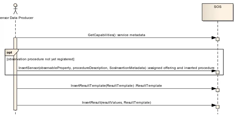
An SOS may support the Result Retrieval requirements class. It contains two operations, GetResultTemplate (Subclause 11.2.1) and GetResult (Subclause 11.2.2), for the retrieval of observation results without the complete set of observation metadata. The purpose of the Result Retrieval requirements class is to allow clients to repeatedly obtain sensor data without having to send and receive requests and responses that largely contain the same data except for a new timestamp. A client can repeatedly request sensor data from one or more sensors on a recurring basis. This is in particular useful in scenarios with restricted bandwidth or clients with restricted processing power. Figure 6 and the following descriptions illustrate the operation sequence for result retrieval.
1. The client invokes the GetResultTemplate operation to retrieve the resultStructure and
the resultEncoding which will be used by the SOS in later GetResult operation
responses.
2. The client calls the GetResult operation and retrieves result values.
Figure 6: Sequence diagram of result retrieval
Sensor Data Producer
SOS
opt
[observation procedure not yet registered]
GetCapabilities() :service metadata
InsertSensor(observableProperty, procedureDescription, SosInsertionMetadata) :assigned offering and inserted procedure
InsertResultT emplate(ResultTemplate) :ResultT emplate
InsertResult(resultValues, ResultTemplate)
SOS
Client
GetResultTemplate(observedProperty, offering) :resultStructure, resultEncoding
8 Requirements Class: Core
Requirements Class
http://www.opengis.net/spec/SOS/2.0/req/core Target Type Web Service
Dependency urn:iso:ts:iso:19156:clause:6
Requirement http://www.opengis.net/spec/SOS/2.0/req/core/gc-observationoffering-structure Requirement http://www.opengis.net/spec/SOS/2.0/req/core/gc-offering-identifier
In this clause, the SOS core operations GetCapabilities, DescribeSensor, and GetObservation are specified.
GetCapabilities - provides access to metadata and detailed information about the operations
available by an SOS server.
DescribeSensor - provides access to detailed information about the sensors and sensor
systems available by an SOS server.
GetObservation - provides access to observations from sensors and sensor systems selected
by spatial, temporal and thematic filtering.
The SOS operations follow the general pattern of other OGC Web Services and where appropriate inherit or re-use elements defined by the OWS Common standard [OGC 06-121r3] and the SWE Service Model standard [OGC 09-001].
All request and response types defined in this standard (except the GetCapabilities request and response which are based on [OGC 06-121r3]) are derived from the ExtensibleRequest or ExtensibleRepsonse type, respectively, as defined in OGC 09-001. Each request and response type defines an optional extension property, a container for request parameters that can be defined by an extension.
This standard defines the following general requirements applying to ALL operations defined in the following (except where explicitly negated):
Requirement http://www.opengis.net/spec/SOS/2.0/req/core/go-response-elements-type
Requirements Class (continued) http://www.opengis.net/spec/SOS/2.0/req/core
Requirement http://www.opengis.net/spec/SOS/2.0/req/core/go-observation-duplicates Requirement http://www.opengis.net/spec/SOS/2.0/req/core/go-exception
Requirement http://www.opengis.net/spec/SOS/2.0/req/core/go-too-many-obs-exception
Requirement
http://www.opengis.net/spec/SOS/2.0/req/core/request-service
Requirement 1 For ALL SOS request types defined in this standard, a mandatory service parameter specifies the OWS type abbreviation of the implementing service. It is of type
CharacterString and shall have the fixed value “SOS”.
Requirement
8.1 GetCapabilities Operation
This operation allows clients to retrieve the service metadata (also called the “Capabilities” document) of an SOS server.
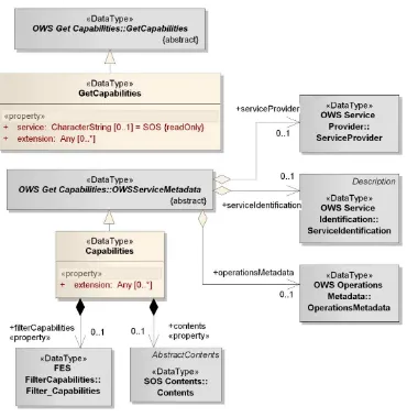
The conceptual model of the GetCapabilities operation is shown in the following UML diagram.
Requirement 2 For ALL SOS request types defined in this standard except the request type of the GetCapabilities operation, a mandatory version parameter specifies the service type specification. It is of type CharacterString and shall have the fixed value “2.0.0”.
Requirement
http://www.opengis.net/spec/SOS/2.0/req/core/gc
8.1.1 Request
The SOS GetCapabilities data type derives from the OWS Common GetCapabilities data type (listed in Table 3 of [06-121r3]) and thus inherits all the properties contained in that data type.
Table 13: Properties in the GetCapabilities data type
Name Definition Data type and values Multiplicity and use
extension container for elements defined by extension specifications
Any type
value is defined by the extension
specification
Zero or more (optional)
service service type identifier Character String type, not empty
value shall be “SOS”
Zero or one (optional) default value is “SOS”
NOTE: the request property – derived from OWS Common GetCapabilities type – is explicit or implied by each specific binding of the GetCapabilities operation, so is not necessarily part of the request representation defined by that binding.
Requirement
http://www.opengis.net/spec/SOS/2.0/req/core/gc-ows
Requirement 4 The GetCapabilities operation request shall be implemented as specified in Clause 7 of OWS Common [OGC 06-121r3].
Requirement
http://www.opengis.net/spec/SOS/2.0/req/core/gc-version
Requirement 5 If the AcceptVersions parameter is contained in the request, it shall contain the character string “2.0.0”.
Requirement
http://www.opengis.net/spec/SOS/2.0/req/core/gc-request-structure
Requirement 6 In addition to the properties inherited from OWS Common GetCapabilities, the SOS GetCapabilities shall include the properties according to Table 13
Requirement
http://www.opengis.net/spec/SOS/2.0/req/core/gc-sections
NOTE: additional sections can be added by extensions; this is done for example by the InsertionCapabilities requirements class (clause 10.1).
Table 14: Additional section names for SOS Capabilities
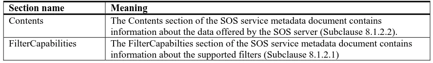
Section name Meaning
Contents The Contents section of the SOS service metadata document contains information about the data offered by the SOS server (Subclause 8.1.2.2). FilterCapabilities The FilterCapabilties section of the SOS service metadata document contains
information about the supported filters (Subclause 8.1.2.1)
8.1.2 Response
The response to a GetCapabilities operation request is also called the Capabilities document. This document provides clients with service metadata about a specific service instance, including metadata about the data served. This clause defines the required elements in a SOS 2.0 Capabilities document.
The SOS Capabilities data type derives from the OWS Common OWSServiceMetadata data type (as defined in clause 7.4.2 of [06-121r3]) and thus inherits all the properties contained in that data type.
Requirement
http://www.opengis.net/spec/SOS/2.0/req/core/gc-response
Requirement 8 If the GetCapabilities request is valid, the server shall return an instance of the SOS Capabilities type else the server shall respond with an exception.
Requirement
http://www.opengis.net/spec/SOS/2.0/req/core/gc-response-structure
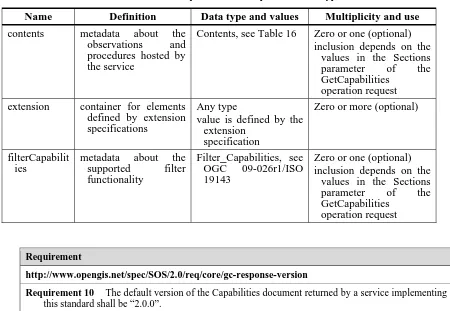
Table 15: Properties in the Capabilities data type
Name Definition Data type and values Multiplicity and use
contents metadata about the observations and procedures hosted by the service
Contents, see Table 16 Zero or one (optional) inclusion depends on the
values in the Sections parameter of the GetCapabilities
operation request extension container for elements
defined by extension specifications
Any type
value is defined by the extension
specification
Zero or more (optional)
filterCapabilit ies
metadata about the supported filter functionality
Filter_Capabilities, see OGC 09-026r1/ISO 19143
Zero or one (optional) inclusion depends on the
values in the Sections parameter of the GetCapabilities
operation request
The ServiceIdentification, ServiceProvider, and OperationsMetadata sections of the
GetCapabilities response document are defined in [OGC 06-121r3].
NOTE Typically, such conformance classes will be specified in SOS extensions.
NOTE Conformance classes from implemented specification (e.g. OGC Filter Encoding Specification or OMXML) should also be listed.
NOTE Inherited conformance classes are listed in the Profile property as well. For example, even though the InsertObservation conformance class has a dependency on the InsertionCapabilities class, both conformance classes are listed rather than just the InsertObservation class.
The OperationsMetadata section specified in [OGC 06-121r3] lists the request types supported
by an SOS server. For the SOS Core, these are GetCapabilities, DescribeSensor, and GetObservation; extensions may add further request types to this list.
Requirement
http://www.opengis.net/spec/SOS/2.0/req/core/gc-response-version
Requirement 10 The default version of the Capabilities document returned by a service implementing this standard shall be “2.0.0”.
Requirement
http://www.opengis.net/spec/SOS/2.0/req/core/gc-conf-class-listing
The following subclauses define the sections of the SOS Capabilities document which are added by this standard, the FilterCapabilities and the Contents section.
8.1.2.1 FilterCapabilities Section
The FilterCapabilities section is imported from [OGC 09-026r1/ISO 19143] and used to state
which filter operators and operands are supported by an SOS server. The operators and operands refer to the parameters of service operations that include OGC filter expressions, like the GetObservation operation.
Example 1An SOS which supports the spatial operator BBOX for the geometry operand gml:Point would list this as shown in the example at
http://schemas.opengis.net/sos/2.0/examples/core/GetCapabilities1_response.xml Requirement
http://www.opengis.net/spec/SOS/2.0/req/core/gc-operation-listing
Requirement 12 The Capabilities document shall include an OperationsMetadata section which contains three Operation elements with case-sensitive name values “GetCapabilities”, “DescribeSensor”, and “GetObservation”. All other operations supported by the SOS server and defined in extensions shall be listed in the same way.
Requirement
http://www.opengis.net/spec/SOS/2.0/req/core/gc-spatialFilter-listing
Requirement 13 The Capabilities document shall include a FilterCapabilities section which lists the spatial filter operators and operands that are supported by the service as defined in section 7.14.5 of [OGC 09-026r1/ISO 19143].
Requirement
http://www.opengis.net/spec/SOS/2.0/req/core/spatial-filter-minimum
Requirement 14 Each SOS shall at least support the spatial filter operator BBOX and shall advertise this in the Capabilities document.
Requirement
http://www.opengis.net/spec/SOS/2.0/req/core/gc-temporalFilter-listing
Example 2An SOS which supports the temporal operators TEquals and During for the temporal operands
gml:TimeInstant and gml:TimePeriod would list these as shown in the example at
http://schemas.opengis.net/sos/2.0/examples/core/GetCapabilities1_response.xml
8.1.2.2 Contents Section
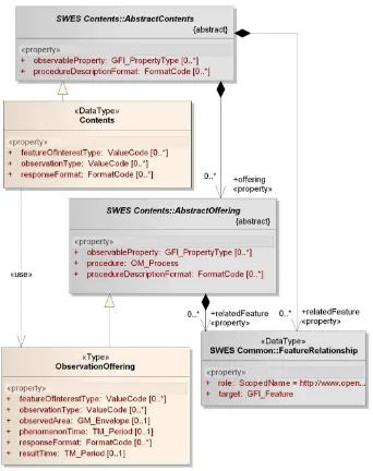
The Contents section of the GetCapabilities response describes the data offered by an SOS server. To group the offered observations the SOS defines the concept of ObservationOfferings.
The Contents type lists all ObservationOfferings of an SOS server. An ObservationOffering
groups collections of observations produced by one procedure, e.g., a sensor system6. The
ObservationOffering lists the basic metadata for the associated observations including the observed properties of the observations. An observation may belong to more than one ObservationOffering.
To summarize: there is a 1:n relationship between procedures and ObservationOfferings; there is a n:m relationship between observations created by these procedures and ObservationOfferings.
NOTE: Observations are usually associated with ONE offering. However, observations from one sensor may be assigned to multiple offerings - a 1:n relationship is allowed. This may be done for the purpose of grouping pre-filtered observations. This way functionality is given which allows grouping of observations according to some thematic criteria. An example is the grouping of severe and all weather forecast observations from the same sensor system into two offerings.
6 A sensor system can be a simple thermometer, but can also consist of several sub-systems. So, a valid sensor system
can be a system of sensors attached to a weather station, or it can be a network of spatially distributed sensors.
Requirement
http://www.opengis.net/spec/SOS/2.0/req/core/temporal-filter-minimum
Requirement 16 Each SOS shall at least support the following temporal filter operators:
a. TEquals operator in conjunction with the TimeInstant type.
b. During operator in conjunction with the TimePeriod type.
An SOS shall advertise the supported filter operators in the Capabilities document.
Requirement
http://www.opengis.net/spec/SOS/2.0/req/core/gc-offerings-observations
Requirement 17 The observations grouped by an ObservationOffering shall not have been created by a procedure other than the one that is stated by the ObservationOffering.
Requirement
http://www.opengis.net/spec/SOS/2.0/req/core/gc-contents
Figure 8: Data types of Contents section
The SOS Contents type derives from the SWES AbstractContents type defined in [OGC
09-001] and inherits its properties.
Those inherited properties are (see clause 7.2.1 in [OGC 09-001] for details):
procedureDescriptionFormat - the identifier of a specific procedure/sensor description
format.
observableProperty - the pointer to a property that can be observed by a procedure, not
relatedFeature - feature that is directly or indirectly observed/observable by a
procedure; can be any feature of which the service provider thinks the procedure can make valuable observations for.
offering - contains metadata about a procedure/sensor hosted by the service.
NOTE: Related features are NOT necessarily features of interest (and associated with observations). The listing of a related feature can be used for discovery purposes by the service provider. The related feature can for example be the
Gulf of Mexico in case an SOS serves data measured by sensors that are carried by marine drifters in the Gulf of
Mexico area. Especially in such cases of mobile sensors, it is not reasonable to list all features of interest (= the sampling locations) as related features, since the Capabilities document would grow too big over time.
Table 16: Properties of Contents data type
Name Definition Data type and
values
Multiplicity
responseFormat Identifies the response format supported for observation retrieval.
FormatCode
Identifies the type of features of interest associated with the observations provided by the service.
ValueCode see clause 8.4.1
Zero or many (optional) observationType Identifies the type of observation (with
unique result type) which is used by the service to encode observations.
ValueCode see clause 8.4.1
Zero or many7 (optional)
The SOS ObservationOffering type derives from the SWES AbstractOffering type defined in OGC 09-001 and inherits all its properties.
Those inherited properties are (see clause 7.2.2 in [OGC 09-001] for details):
procedure - Pointer to the procedure/sensor associated with this offering.
As well as, procedureDescriptionFormat, observableProperty, and relatedFeature
as already described above.
7 The design decision for specifying the multiplicity as “zero or many” instead of “zero or one” is that there may be
many observable properties per ObservationOffering. Each one could use a different observation type or result type. However, a known issue is that the relation between observable property and observation / result type cannot be reflected in the Capabilities. The description of the procedure associated with a given ObservationOffering may provide more detailed information on this relationship.
Requirement
http://www.opengis.net/spec/SOS/2.0/req/core/gc-contents-structure
Table 17: Properties of ObservationOffering data type
Name Definition Data type and
values
Multiplicity and use
phenomenonTime temporal bounding box of the phenomenon times of all observations belonging to the offering
TM_Period see [ISO 19108]
Zero or one (optional) omit only if the offering has no observations associated to it resultTime temporal bounding box of the result times
of all observations belonging to the offering offering has no observations associated to it observedArea spatial bounding box of the spatial extent
of all features of interest that belong to observations associated with the offering
GM_Envelope see [ISO 19107]
Zero or one (optional)
responseFormat As defined in Table 16.
featureOfInterestType As defined in Table 16.
observationType As defined in Table 16.
For the purpose of reducing the amount of redundant information in the Capabilities document, the SOS supports a so-called property inheritance mechanism as defined in [OGC 09-001].
8 See Annex 15 for a detailed discussion of identifier handling. Requirement
http://www.opengis.net/spec/SOS/2.0/req/core/gc-observationoffering-structure
Requirement 20 In addition to the properties inherited from SWES AbstractOffering, the SOS ObservationOffering shall include the properties according to Table 17
Requirement
http://www.opengis.net/spec/SOS/2.0/req/core/gc-offering-identifier
Requirement 21 The service shall assign a unique identifier value to each of its ObservationOfferings8. This value shall be set in the swes:identifier property that each
ObservationOffering automatically has (see [OGC 09-001] for further details).
Requirement
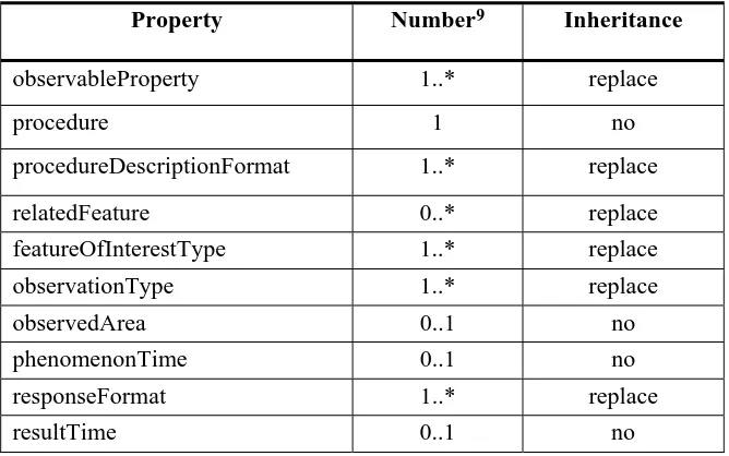
The following table shows which of the properties of an ObservationOffering can be inherited and which cardinality is expected after the inheritance mechanism has been applied.
Clients need to apply the SWES property inheritance mechanism according to the inheritance categories defined for the ObservationOffering properties in Table 18 when determining their values (for a given offering).
Table 18: Inheritance of ObservationOffering properties (from Contents)
Property Number9 Inheritance
observableProperty 1..* replace
procedure 1 no
procedureDescriptionFormat 1..* replace
relatedFeature 0..* replace
featureOfInterestType 1..* replace
observationType 1..* replace
observedArea 0..1 no
phenomenonTime 0..1 no
responseFormat 1..* replace
resultTime 0..1 no
Thus, even though the UML model and schema encoding define, for example, the
observationType and responseFormat properties as optional, they are mandatory in each
ObservationOffering. In other words, each offering has to include at least one value for these two properties after the property inheritance mechanism was applied.
As O&M v2.0 XML encoding (OMXML 2.0) is the only mandatory format for observation data at a SOS 2.0:
9 The design decisions for specifying those multiplicities are the following: The observableProperty,
procedureDescriptionFormat, featureOfInterestType, and observationType are required as this information needs to be provided in the InsertSensor request and thus has to be provided even if no observations are assigned to the ObservationOffering yet (and even if the InsertSensor operation is not implemented). The responseFormat is required as Requirement 23 states that the default response format must be listed explicitly. The phenomenonTime/resultTime is omitted if no observation has been associated to the offering yet. This would for example be the case right after a new sensor was inserted at the service.
Requirement 22 The ObservationOffering is a property inheritor and the Contents its property provider as defined by OGC 09-001.
The service shall ensure that the number of values it provides for the properties of each offering is as stated in Table 18 when the property inheritance mechanism was applied.