Date: 2011-03-28
Reference number of this document: OGC 09-000
OGC name of this OGC® project document: http://www.opengis.net/doc/IS/SPS/2.0
Version:2.0
Category: OpenGIS® Implementation Standard
Editor(s):Ingo Simonis, Johannes Echterhoff
OGC
®Sensor Planning Service Implementation Standard
Copyright © 2011 Open Geospatial Consortium
To obtain additional rights of use, visit http://www.opengeospatial.org/legal/.
Warning
This document is an OGC Member approved international standard. This document is available on a royalty free, non-discriminatory basis. Recipients of this document are invited to submit, with their comments, notification of any relevant patent rights of which they are aware and to provide supporting documentation.
Document type: OpenGIS® Standard
Document subtype: Interface
Document stage: Approved
Document language: English
ii Copyright © 2012 Open Geospatial Consortium
License Agreement
Permission is hereby granted by the Open Geospatial Consortium, ("Licensor"), free of charge and subject to the terms set forth below, to any person obtaining a copy of this Intellectual Property and any associated documentation, to deal in the Intellectual Property without restriction (except as set forth below), including without limitation the rights to implement, use, copy, modify, merge, publish, distribute, and/or sublicense copies of the Intellectual Property, and to permit persons to whom the Intellectual Property is furnished to do so, provided that all copyright notices on the intellectual property are retained intact and that each person to whom the Intellectual Property is furnished agrees to the terms of this Agreement.
If you modify the Intellectual Property, all copies of the modified Intellectual Property must include, in addition to the above copyright notice, a notice that the Intellectual Property includes modifications that have not been approved or adopted by LICENSOR.
THIS LICENSE IS A COPYRIGHT LICENSE ONLY, AND DOES NOT CONVEY ANY RIGHTS UNDER ANY PATENTS THAT MAY BE IN FORCE ANYWHERE IN THE WORLD.
THE INTELLECTUAL PROPERTY IS PROVIDED "AS IS", WITHOUT WARRANTY OF ANY KIND, EXPRESS OR IMPLIED, INCLUDING BUT NOT LIMITED TO THE WARRANTIES OF MERCHANTABILITY, FITNESS FOR A PARTICULAR PURPOSE, AND NONINFRINGEMENT OF THIRD PARTY RIGHTS. THE COPYRIGHT HOLDER OR HOLDERS INCLUDED IN THIS NOTICE DO NOT WARRANT THAT THE FUNCTIONS CONTAINED IN THE INTELLECTUAL PROPERTY WILL MEET YOUR REQUIREMENTS OR THAT THE OPERATION OF THE INTELLECTUAL PROPERTY WILL BE UNINTERRUPTED OR ERROR FREE. ANY USE OF THE INTELLECTUAL PROPERTY SHALL BE MADE ENTIRELY AT THE USER’S OWN RISK. IN NO EVENT SHALL THE COPYRIGHT HOLDER OR ANY CONTRIBUTOR OF INTELLECTUAL PROPERTY RIGHTS TO THE INTELLECTUAL PROPERTY BE LIABLE FOR ANY CLAIM, OR ANY DIRECT, SPECIAL, INDIRECT OR CONSEQUENTIAL DAMAGES, OR ANY DAMAGES WHATSOEVER RESULTING FROM ANY ALLEGED INFRINGEMENT OR ANY LOSS OF USE, DATA OR PROFITS, WHETHER IN AN ACTION OF CONTRACT, NEGLIGENCE OR UNDER ANY OTHER LEGAL THEORY, ARISING OUT OF OR IN CONNECTION WITH THE IMPLEMENTATION, USE, COMMERCIALIZATION OR PERFORMANCE OF THIS INTELLECTUAL PROPERTY.
This license is effective until terminated. You may terminate it at any time by destroying the Intellectual Property together with all copies in any form. The license will also terminate if you fail to comply with any term or condition of this Agreement. Except as provided in the following sentence, no such termination of this license shall require the termination of any third party end-user sublicense to the Intellectual Property which is in force as of the date of notice of such termination. In addition, should the Intellectual Property, or the operation of the Intellectual Property, infringe, or in LICENSOR’s sole opinion be likely to infringe, any patent, copyright, trademark or other right of a third party, you agree that LICENSOR, in its sole discretion, may terminate this license without any compensation or liability to you, your licensees or any other party. You agree upon termination of any kind to destroy or cause to be destroyed the Intellectual Property together with all copies in any form, whether held by you or by any third party.
Except as contained in this notice, the name of LICENSOR or of any other holder of a copyright in all or part of the Intellectual Property shall not be used in advertising or otherwise to promote the sale, use or other dealings in this Intellectual Property without prior written authorization of LICENSOR or such copyright holder. LICENSOR is and shall at all times be the sole entity that may authorize you or any third party to use certification marks, trademarks or other special designations to indicate compliance with any LICENSOR standards or specifications.
This Agreement is governed by the laws of the Commonwealth of Massachusetts. The application to this Agreement of the United Nations Convention on Contracts for the International Sale of Goods is hereby expressly excluded. In the event any provision of this Agreement shall be deemed unenforceable, void or invalid, such provision shall be modified so as to make it valid and enforceable, and as so modified the entire Agreement shall remain in full force and effect. No decision, action or inaction by LICENSOR shall be construed to be a waiver of any rights or remedies available to it.
ii Co
Contents
Page1 Scope ...1
2 Compliance ...2
2.1 Specification identifier ...2
2.2 Conformance Classes ...2
3 Normative references ...4
4 Terms and definitions ...6
5 Conventions ...7
5.1 Abbreviated terms ...7
5.2 UML notation ...8
5.3 Platform-neutral and platform-specific standards ...8
5.4 Data dictionary tables ...8
5.5 Classes imported from other specifications with predefined XML encoding ...8
5.6 Namespace Conventions ...10
6 Sensor Planning Service – Abstract Overview ...11
6.1 Introduction ...11
6.2 Client Server Interaction ...12
6.3 Task – Concept and Handling ...15
6.3.1 Introduction ...15
6.3.2 Tasking Parameters ...16
6.3.3 Tasking requests...16
6.3.4 Feasibility of a Task ...17
6.3.5 Reserving a Task ...19
6.3.6 State Handling ...19
6.4 Status Reporting ...22
6.5 Levels of Abstraction – SPS Chains ...22
6.6 Asynchronous Communication ...23
6.7 Information Access ...24
7 Sensor Planning Service – Implementation Model ...25
7.1 Interface Overview ...25
7.2 SPS Exceptions ...29
7.3 Package Overview ...31
7.3.1 Common Package ...34
7.3.1.1 Introduction ...34
7.3.1.2 Data Types ...34
7.3.1.3 TaskingRequest ...36
7.3.1.4 TaskingResponse ...38
7.3.1.5 StatusReport ...41
7.3.1.6 Task 45 7.3.1.7 TaskingRequestStatusCode ...46
7.3.1.8 TaskStatusCode...47
Copyright © 2011 Open Geospatial Consortium iii
7.3.1.9 EventCode ...48
7.3.1.10 Alternative...50
7.3.1.11 ParameterData ...50
7.3.2 GetCapabilities Operation ...51
7.3.2.1 Introduction ...51
7.3.2.2 Data Types ...51
7.3.2.3 Operation Request – GetCapabilities ...52
7.3.2.4 Operation Response – Capabilities ...54
7.3.2.5 Exceptions ...59
7.3.2.6 Examples ...59
7.3.3 Contents Package ...59
7.3.3.1 Introduction ...59
7.3.3.2 Data Types ...59
7.3.3.3 SPSContents ...61
7.3.3.4 SensorOffering ...62
7.3.3.5 PointOrPolygon...63
7.3.4 DescribeTasking Operation ...63
7.3.4.1 Introduction ...63
7.3.4.2 Data Types ...64
7.3.4.3 Operation Request - DescribeTasking ...64
7.3.4.4 Operation Response - DescribeTaskingResponse ...65
7.3.4.5 Exceptions ...66
7.3.4.6 Examples ...66
7.3.5 Submit Operation ...66
7.3.5.1 Introduction ...66
7.3.5.2 Data Types ...66
7.3.5.3 Operation Request - Submit ...68
7.3.5.4 Operation Response - SubmitResponse ...68
7.3.5.5 Exceptions ...70
7.3.5.6 Examples ...70
7.3.6 GetStatus Operation ...71
7.3.6.1 Introduction ...71
7.3.6.2 Data Types ...72
7.3.6.3 Operation Request - GetStatus ...73
7.3.6.4 Operation Response - GetStatusResponse ...74
7.3.6.5 Exceptions ...83
7.3.6.6 Examples ...83
7.3.7 GetTask Operation ...83
7.3.7.1 Introduction ...83
7.3.7.2 Data Types ...84
7.3.7.3 Operation Request – GetTask ...84
7.3.7.4 Operation Response – GetTaskResponse ...85
7.3.7.5 Exceptions ...86
7.3.7.6 Examples ...87
7.3.8 DescribeResultAccess Operation ...87
7.3.8.1 Introduction ...87
iv Co
7.3.8.3 Operation Request – DescribeResultAccess ...96
7.3.8.4 TaskOrProcess ...97
7.3.8.5 Operation Response - DescribeResultAccessResponse ...98
7.3.8.6 AvailableOrNot ...98
7.3.8.7 DataAvailable ...99
7.3.8.8 DataNotAvailable ...100
7.3.8.9 UnavailableCode ...100
7.3.8.10 SPSMetadata ...101
7.3.8.11 Exceptions ...102
7.3.8.12 Examples ...102
7.3.9 Reserve Operation ...103
7.3.9.1 Introduction ...103
7.3.9.2 Data Types ...103
7.3.9.3 Operation Request - Reserve ...105
7.3.9.4 Operation Response - ReservationReport ...105
7.3.9.5 ReservationReport ...107
7.3.9.6 Exceptions ...108
7.3.9.7 Examples ...108
7.3.10 Confirm Operation ...108
7.3.10.1 Introduction ...108
7.3.10.2 Data Types ...108
7.3.10.3 Operation Request - Confirm ...109
7.3.10.4 Operation Response - ConfirmResponse ...110
7.3.10.5 Exceptions ...111
7.3.10.6 Examples ...111
7.3.11 GetFeasibility Operation ...112
7.3.11.1 Introduction ...112
7.3.11.2 Data Types ...112
7.3.11.3 Operation Request - GetFeasibility ...113
7.3.11.4 Operation Response - GetFeasibilityResponse ...114
7.3.11.5 Exceptions ...115
7.3.11.6 Examples ...116
7.3.12 Update Operation ...116
7.3.12.1 Introduction ...116
7.3.12.2 Data Types ...117
7.3.12.3 Operation Request - Update ...118
7.3.12.4 Operation Response - UpdateResponse ...119
7.3.12.5 Exceptions ...122
7.3.12.6 Examples ...122
7.3.13 Cancel Operation ...122
7.3.13.1 Introduction ...122
7.3.13.2 Data Types ...122
7.3.13.3 Operation Request - Cancel ...123
7.3.13.4 Operation Response - CancelResponse ...124
7.3.13.5 Exceptions ...125
7.3.13.6 Examples ...126
7.4 SPS tasking parameters representation ...127
Copyright © 2011 Open Geospatial Consortium v
7.4.1 Optional Parameters ...128
7.4.2 Default Values ...129
7.4.3 Updatable parameters ...130
7.4.4 Constraints/restrictions ...132
7.4.5 Definition (observedProperty)/Semantics ...133
7.4.6 Uoms ...133
7.4.7 Encoding (XML, text, binary) ...133
8 Publish/Subscribe ...133
8.1 Introduction ...133
8.2 SPS Events ...134
8.3 Channel based filtering/SPS notification topics ...136
9 SOAP binding ...140
9.1 Introduction ...140
9.2 Exceptions ...140
9.2.1 StatusInformationExpired exception ...140
9.2.2 ModificationOfFinalizedTask exception ...141
9.3 Action URIs ...141
9.4 Realization of Publish/Subscribe ...145
9.5 Realization of Asynchronous Request/Response ...145
9.6 SPS Examples Scenario ...145
9.6.1 Retrieving the Capabilities Document ...146
9.6.2 Getting Result Access Information for a Procedure ...150
9.6.3 Getting the Tasking Parameter Description ...151
9.6.4 Determining the Feasibility of a Tasking Request ...153
9.6.5 Scheduling a Task (Submit / Reserve) ...154
9.6.5.1 Task Submission ...154
9.6.5.2 Reserving a Task ...155
9.6.5.3 Automatic Reservation Expiration ...156
9.6.5.4 Confirming a Reserved Task ...157
9.6.5.5 Cancelling a Scheduled Task ...158
9.6.5.6 Task Failure ...159
9.6.5.7 Updating a Scheduled Task ...159
9.6.5.8 Usage of LatestResponseTime ...162
9.6.5.9 Task Completion ...163
9.6.6 Getting Result Access Information for a Task ...165
9.6.7 Service Exceptions ...167
9.6.8 Notifications ...168
9.6.9 Using WS-Addressing ...172
10 SPS Task/Tasking Request State Machine Documentation ...177
10.1 Task State Machine ...177
10.1.1 Diagrams ...177
10.1.2 States/Choices ...179
10.1.2.1 Scheduled State ...180
10.1.2.2 InExecution State ...181
10.1.2.3 Reserved State ...183
vi Co
10.1.2.5 Final State ...184
10.1.2.6 Initial State ...185
10.1.3 Events/Trigger ...186
10.1.3.1 DataPublished ...186
10.1.3.2 ReservationExpired ...186
10.1.3.3 TaskCancelled ...186
10.1.3.4 TaskCompleted ...186
10.1.3.5 TaskConfirmed ...187
10.1.3.6 TaskFailed ...187
10.1.3.7 TaskReserved ...187
10.1.3.8 TaskSubmitted ...187
10.1.3.9 TaskUpdated ...187
10.2 Tasking Request State Machine ...187
10.2.1 Diagrams ...187
10.2.2 States/Choices ...188
10.2.2.1 Pending State ...188
10.2.2.2 Accepted State ...189
10.2.2.3 ChoiceA ...190
10.2.2.4 ChoiceB...190
10.2.2.5 Initial State ...191
10.2.2.6 Rejected (Final) State ...191
10.2.3 Events/Trigger ...192
10.2.3.1 TaskingRequestAccepted ...192
10.2.3.2 TaskingRequestExpired ...192
10.2.3.3 TaskingRequestRejected ...193
10.2.3.4 TaskingRequestPending ...193
11 Annex A – Abstract Test Suite and Conformance Testing (normative) ...194
11.1 Conformance Class – Core ...194
11.1.1 Capability Test ...194
11.1.2 Modules with Basic Tests ...194
11.1.2.1 Common Request Response Handling...194
11.1.2.2 Exception Reporting ...195
11.1.2.3 Service Metadata ...196
11.1.2.4 DescribeTasking ...199
11.1.2.5 Tasking ...200
11.1.2.6 State Handling ...201
11.1.2.7 Submit ...204
11.1.2.8 Result Handling ...205
11.2 Conformance Class – State Logger ...207
11.2.1 Capability Test ...207
11.2.2 Modules with Basic Tests ...208
11.2.2.1 Service Metadata ...208
11.2.2.2 Behavior ...208
11.3 Conformance Class – Reservation Manager ...209
11.3.1 Capability Test ...209
11.3.2 Modules with Basic Tests ...210
11.3.2.1 Structure ...210
Copyright © 2011 Open Geospatial Consortium vii
11.3.2.2 Service Metadata ...210
11.3.2.3 Behavior ...211
11.4 Conformance Class – Task Canceller ...212
11.4.1 Capability Test ...212
11.4.2 Modules with Basic Tests ...212
11.4.2.1 Structure ...212
11.4.2.2 Behavior ...213
11.4.2.3 Service Metadata ...213
11.5 Conformance Class – Feasibility Controller ...213
11.5.1 Capability Test ...213
11.5.2 Modules with Basic Tests ...214
11.5.2.1 Structure ...214
11.5.2.2 Service Metadata ...214
11.6 Conformance Class – Task Updater ...214
11.6.1 Capability Test ...214
11.6.2 Modules with Basic Tests ...215
11.6.2.1 Structure ...215
11.6.2.2 Behavior ...215
11.6.2.3 Service Metadata ...217
11.7 Conformance Class – Basic PubSub ...218
11.7.1 Capability Test ...218
11.7.2 Modules with Basic Tests ...218
11.7.2.1 Event Publication ...218
11.7.2.2 Notification Service Metadata ...219
11.8 Conformance Class – Channel Based PubSub ...219
11.8.1 Capability Test ...219
11.8.2 Modules with Basic Tests ...220
11.8.2.1 Channel based Event Publication ...220
11.8.2.2 Channel based Notification Service Metadata ...220
11.9 Conformance Class – XML Encoding ...221
11.9.1 Capability Test ...221
11.9.2 Modules with Basic Tests ...221
11.9.2.1 Validation ...221
11.10 Conformance Class – SOAP ...222
11.10.1 Capability Test ...222
11.10.2 Modules with Basic Tests ...222
11.10.2.1 Action URIs ...222
11.10.2.2 Exception Handling ...223
11.10.2.3 Service Metadata ...223
12 Annex B - XML Schema Documents (normative) ...225
viii Co
Figures
PageFigure 1 - SPS Conformance Classes and their dependencies ...4
Figure 2 — SWE Interface of an Asset (Management System) ...11
Figure 3 — client server interaction part 1 ...12
Figure 4 — client server interaction part 2 ...13
Figure 5 — client server interaction part 3 ...14
Figure 6 — client server interaction part 4 ...15
Figure 7 — dynamics of a feasibility study result ...18
Figure 8 — tasking request state machine diagram ...20
Figure 9 — task state machine diagram ...21
Figure 10 — tasking on various abstraction levels ...23
Figure 11 — SPS interfaces UML diagram ...26
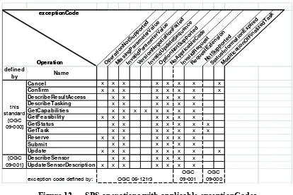
Figure 12 — SPS operations with applicable exceptionCodes ...30
Figure 13 — SPS model external dependencies ...32
Figure 14 — SPS package dependencies ...32
Figure 15 — Data types contained in the Common package ...35
Figure 16 — Data types of the GetCapabilities operation ...52
Figure 17 — Data types contained in the Contents package ...60
Figure 18 — Data types of the DescribeTasking operation ...64
Figure 19 — Data types of the Submit operation ...67
Figure 20 — Data types of the GetStatus operation ...73
Figure 21 – Status information returned for various exemplary tasks/tasking requests when the “since” parameter was used in GetStatus request ...77
Figure 22 – Status information returned for various exemplary tasks/tasking requests when the “since” parameter was not used in GetStatus request ...78
Figure 23 — Data types of the GetTask operation ...84
Figure 24 – Status information returned in the GetTaskResponse for various exemplary tasks/tasking requests when the state logger conformance class is supported by the service...86
Figure 25 — Mapping of UML Reference elements to XML Schema elements. Rarely used elements are grayed out ...94
Figure 26 — Data types of the DescribeResultAccess operation ...96
Copyright © 2011 Open Geospatial Consortium ix
Figure 27 — Data types of the Reserve operation ...104
Figure 28 — Data types of the Confirm operation ...109
Figure 29 — Data types of the GetFeasibility operation ...113
Figure 30 — Data types of the Update operation ...118
Figure 31 — Data types of the Cancel operation ...123
Figure 32 — task state machine diagram ...178
Figure 33 — task state machine diagram – tabular representation ...179
x Co
Tables
PageTable 1 — SPS Conformance Classes ... 3
Table 2 — Implementation of types from OWS Common [OGC 06-121r3] ... 9
Table 3 — Implementation of types from SWE Common Data Model [OGC 08-094] ... 9
Table 4 — Implementation of types from SWE Service Model [OGC 09-001] ... 9
Table 5 — Prefixes and Namespaces used in this standard ... 10
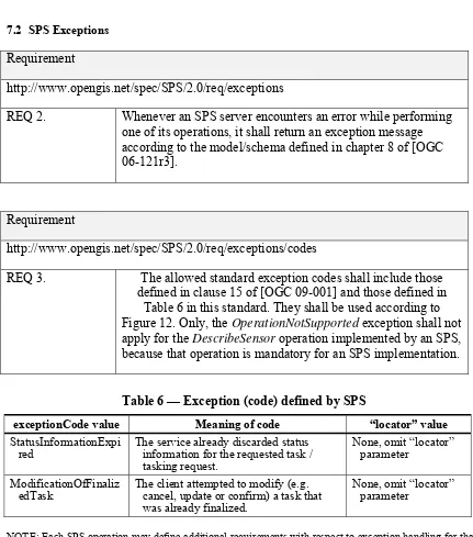
Table 6 — Exception (code) defined by SPS ... 29
Table 7 — Properties in the TaskingRequest data type ... 38
Table 8 — Status Codes, usage and meaning in TaskingResponse specializations ... 40
Table 9 — Properties in the TaskingResponse data type ... 41
Table 10 — Properties in the StatusReport data type ... 44
Table 11 — Properties in the Task data type ... 46
Table 12 — Properties in the TaskingRequestStatusCode code list ... 47
Table 13 — Properties in the TaskStatusCode code list ... 48
Table 14 — Properties in the EventCode code list ... 49
Table 15 — Properties in the Alternative data type ... 50
Table 16 — Properties in the ParameterData data type ... 51
Table 17 — Properties in the GetCapabilities data type ... 53
Table 18 — Additional Section name value and meaning ... 53
Table 19 — Implementation of parameters in GetCapabilities operation request ... 54
Table 20 — Properties in the Capabilities data type ... 55
Table 21 — SPS section name values and contents ... 56
Table 22 — Required values of OperationsMetadata section attributes ... 57
Table 23 — Optional values of OperationsMetadata section attributes ... 57
Table 24 — Properties in the SPSContents data type ... 61
Table 25 — Code values applicable to the supportedEncoding property ... 62
Table 26 — Properties in the SensorOffering type ... 62
Table 27 — Inheritance of SensorOffering properties (from SPSContents) ... 63
Table 28 — Properties in the PointOrPolygon union ... 63
Table 29 — Property in the DescribeTasking data type ... 65
Table 30 – Properties in the DescribeTaskingResponse data type ... 65
Table 31 – StatusReport usage for different state transitions of a Submit request ... 69
Copyright © 2011 Open Geospatial Consortium xi
Table 32 — Properties in the GetStatus data type ... 74
Table 33 — Properties in the GetStatusResponse data type ... 75
Table 34 – Providing status information on GetFeasibility and Update requests ... 79
Table 35 – Providing status information on Reserve and Submit requests ... 80
Table 36 – Providing status information on scheduled tasks (part 1) ... 81
Table 37 – Providing status information on scheduled tasks (part 2) ... 82
Table 38 — Properties in the GetTask data type ... 85
Table 39 — Properties in the GetTaskResponse data type ... 85
Table 40 — Semantics of DescribeResultAccess operation request using task or procedure identifier ... 87
Table 41 – Service Reference Mapping ... 90
Table 42 – Examples of applicable mime types when referencing data ... 94
Table 43 — Property in the DescribeResultAccess data type ... 97
Table 44 — Properties in the TaskOrProcess union ... 98
Table 45 — Property in the DescribeResultAccessResponse data type ... 98
Table 46 — Properties in the AvailableOrNot union ... 99
Table 47 — Property in the DataAvailable data type ... 99
Table 48 — Properties in the DataNotAvailable data type ... 100
Table 49 — Properties in the UnavailableCode code list ... 101
Table 50 — Properties in the SPSMetadata data type ... 102
Table 51 — Property in the Reserve data type ... 105
Table 52 – StatusReport usage for different state transitions of a Reserve request ... 107
Table 53 — Property in the ReservationReport type ... 108
Table 54 — Property in the Confirm data type ... 110
Table 55 — Property in the ConfirmResponse data type ... 110
Table 56 – StatusReport property usage in Confirm operation response ... 111
Table 57 – StatusReport usage for different state transitions of a GetFeasibility request . 115 Table 58 — Property in the Update data type ... 119
Table 59 — Property in the UpdateResponse data type ... 120
Table 60 – StatusReport usage for different state transitions of an Update request... 121
Table 61 — Property in the Cancel data type ... 124
Table 62 — Properties in the CancelResponse data type ... 124
Table 63 – StatusReport property usage in Cancel operation response ... 125
Table 64 — SPS Events and their encoding ... 134
Table 65 – StatusReport encoding for notification of tasking request state transition ... 136
xii Co
Table 67 — Topics and the events posted on them ... 139
Table 68 — Action URIs for SPS message facets ... 143
Table 69 — Action URI for SPS exceptions/fault types ... 144
Table 70 — Connections of the Scheduled state ... 181
Table 71 — Connections of the InExecution state ... 182
Table 72 — Connections of the Reserved state ... 183
Table 73 — Connections of the Tasking Request choice ... 184
Table 74 — Connections of the Final state ... 185
Table 75 — Connections of the Initial state ... 186
Table 76 — Connections of the Pending state ... 189
Table 77 — Connections of the Accepted state ... 190
Table 78 — Connections of the ChoiceA choice ... 190
Table 79 — Connections of the ChoiceB choice ... 191
Table 80 — Connections of the Initial state ... 191
Table 81 — Connections of the Rejected state ... 192 Table 82 — XML Schema implementation of types defined by the SPS conceptual model 226
Copyright © 2011 Open Geospatial Consortium xiii
i.
Abstract
The OpenGIS® Sensor Planning Service Interface Standard (SPS) defines interfaces for queries that provide information about the capabilities of a sensor and how to task the sensor. The standard is designed to support queries that have the following purposes: to determine the feasibility of a sensor planning request; to submit and reserve/commit such a request; to inquire about the status of such a request; to update or cancel such a request; and to request information about other OGC Web services that provide access to the data collected by the requested task. This is one of the OGC Sensor Web Enablement (SWE) [http://www.opengeospatial.org/ogc/markets-technologies/swe] suite of standards.
ii.
Keywords
ogcdoc, sps, swe, swes, gml
iii.
Preface
This standard is part of OGC’s Sensor Web Enablement (SWE) activity. It is the successor of SPS version 1.0.0 (OGC 07-014r3).
Suggested additions, changes, and comments on this report are welcome and encouraged. Such suggestions may be submitted using the OGC online change request application: http://portal.opengeospatial.org/public_ogc/change_request.php
iv.
Document terms and definitions
This document uses the standard terms defined in Subclause 5.3 of [OGC 06-121r3], which is based on the ISO/IEC Directives, Part 2. Rules for the structure and drafting of International Standards. In particular, the word “shall” (not “must”) is the verb form used to indicate a requirement to be strictly followed to conform to this standard.
v.
Submitting organizations
The following organizations submitted this document to the Open Geospatial Consortium Inc.
a) International Geospatial Services Institute GmbH (iGSI) b) Spot Image, S.A.
xiv Co
vi.
Document contributor contact points
All questions regarding this document should be directed to the editor or the contributors:
CONTACT COMPANY EMAIL
Johannes Echterhoff (editor) iGSI [email protected]
Ingo Simonis (editor) iGSI [email protected]
Alexandre Robin Spot Image, S.A. [email protected]
Jim Greenwood SeiCorp, Inc. [email protected]
vii.
Issues
Any issues in this specification are captured in the following format:
Issue Name: [Issue Name goes here.] (Your Initials, Date) Issue Description: [Issue Description.]
Resolution: [Insert Resolution Details and History.] (Your Initials, Date)]
viii.
Changes to the OGC Abstract Specification
The OpenGIS® Abstract Specification does not require changes to accommodate the technical contents of this document.
ix.
Future work
Future Work will mainly address the abstraction of the currently operation-based specification to a behavior-based specification. Then, all binding approaches, such as SOAP or REST, will be defined in extensions to the core specification.
Direct subscriptions together with a tasking request are currently out-of-scope for the standard. This can lead to situations in which a client interested in receiving notifications about that tasking request or implied task misses published notifications. Functionality to enable performing a tasking request and directly subscribing for notification of related events should be realized in the future – either in a revision of the standard itself or as an extension.
Conditional dependencies between parameters (example: if parameter A has value Y then parameter B may only have value Z etc) can be supported in future versions of this standard. The functionality could also be added through extensions.
Copyright © 2011 Open Geospatial Consortium xv During the development of this standard, the OGC has changed its specification
xvi Co
Foreword
This SPS 2.0 standard replaces version 1.0 of the SPS standard (OGC 07-014r3). Version 2 revises and extends version 1. Though the general functionality of the service is
preserved, the interface defined in this document is not backwards compatible to that of SPS version 1.0.0
The Sensor Planning Service is part of the OGC Sensor Web Enablement document suite. This document includes three annexes. Annexes A and B are normative, and Annex C is informative.
Attention is drawn to the possibility that some of the elements of this document may be the subject of patent rights. The Open Geospatial Consortium shall not be held
responsible for identifying any or all such patent rights.
Recipients of this document are requested to submit, with their comments, notification of any relevant patent claims or other intellectual property rights of which they may be aware that might be infringed by any implementation of the standard set forth in this document, and to provide supporting documentation.
Copyright © 2011 Open Geospatial Consortium xvii
Introduction
The Sensor Planning Service (SPS) is intended to provide a standard interface to task collection assets (i.e., satellites, other sensors, and other information gathering assets) and to the support systems that surround them. Not only will different kinds of assets with differing capabilities be supported, but also different kinds of request processing systems, which may or may not provide access to the different stages of planning, scheduling, tasking, collection, processing, archiving, and distribution of requests and the resulting observation data and information that is the result of the requests. The SPS is designed to be flexible enough to handle such a wide variety of configurations.
Copyright © 2011 Open Geospatial Consortium 1
OpenGIS
®Sensor Planning Service Implementation Standard
1 Scope
This OGC™ standard establishes the baseline of Sensor Planning Service functionality and requirements describing this functionality.
This document defines service interfaces for parameterizing – also called tasking – of taskable devices, such as sensors or actuators.
It defines terms and their synonyms relevant to the device control domain (task, tasking, sensor, asset etc).
The interfaces defined in this document provide functionality to:
• Retrieve metadata about the service (to understand service capabilities)
• Describe the parameterization options available for the sensor
• Check if the service is capable of performing a planned task (feasibility check)
• Reserve resources required to perform a planned task for a certain amount of time (useful for handling combined tasking of multiple sensors)
• Instruct the service to execute a task for a sensor
• Retrieve the status of a task
• Update a task
• Retrieve information about access to the data collected by a sensor – also on a per-task basis
• Cancel a task
This document leverages functionality defined by other standards, which enables:
• Provision and management of sensor descriptions
• Publication of and subscription for information on events recognized by the service – for example to automatically notify clients of new information on their task (that new data is available, that it was completed etc.)
The first sections of this document describe the theoretical background to understand SPS functionalities. After that, the common information and communication model for SPS is specified.
2 Copyright © 2011 Open Geospatial Consortium 2 Compliance
2.1 Specification identifier
All requirements and conformance-classes described in this document are owned by the standard identified as http://www.opengis.net/spec/SPS/2.0.
2.2 Conformance Classes
Copyright © 2011 Open Geospatial Consortium 3 Table 1 — SPS Conformance Classes
Conformance
The server implements the GetCapabilities, DescribeTasking, Submit, GetStatus, GetTask and DescribeResultAccess operations as defined by this standard as well as the conformance classe(s) that this conformance class depends upon (see Figure 1).
State Logger http://www.opengis.net/sp ec/SPS/2.0/conf/StateLo gger
The server implements state logger functionality as defined by this standard as well as the conformance classe(s) that this conformance class depends upon (see Figure 1).
Feasibility Controller
http://www.opengis.net/sp ec/SPS/2.0/conf/Feasibil ityController
The server implements the GetFeasibility operation as well as the conformance classe(s) that this conformance class depends upon (see Figure 1).
The server implements the Reserve and Confirm operations as well as the conformance classe(s) that this conformance class depends upon (see Figure 1).
Task Updater http://www.opengis.net/sp ec/SPS/2.0/conf/TaskUp dater
The server implements the Update operation as well as the conformance classe(s) that this conformance class depends upon (see Figure 1). Task
Canceller
http://www.opengis.net/sp ec/SPS/2.0/conf/TaskCa nceller
The server implements the Cancel operation as well as the conformance classe(s) that this conformance class depends upon (see Figure 1). Basic PubSub http://www.opengis.net/sp
ec/SPS/2.0/conf/BasicPu bSub
The server implements publish/subscribe
functionality and publish SPS events as defined in this standard as well as the conformance classe(s) that this conformance class depends upon (see Figure 1).
The server implements publish/subscribe
functionality and publish SPS events on the SPS channels/topics as defined by this standard as well as the conformance classe(s) that this conformance class depends upon (see Figure 1). XML
Encoding
http://www.opengis.net/sp ec/SPS/2.0/conf/XMLEn coding
The server encodes the data types from the conceptual model in XML as defined by this standard as well as the conformance classe(s) that this conformance class depends upon (see Figure 1).
SOAP http://www.opengis.net/sp ec/SPS/2.0/conf/SOAP
4 Co
Figure 1 - SPS Conformance Classes and their dependencies
3 Normative references
The following normative documents contain provisions that, through reference in this text, constitute provisions of this document. For dated references, subsequent
amendments to, or revisions of, any of these publications do not apply. For undated references, the latest edition of the normative document referred to applies.
ISO 19105:2000, Geographic information — Conformance and Testing ISO 19108:2002, Geographic information — Temporal schema
ISO 19136:2007, Geographic information -- Geography Markup Language (GML) (see also: OpenGIS® Encoding Standard Geography Markup Language, OGC document 07-036)
ISO DIS 19156:2010, Geographic information — Observations and Measurements OGC 06-121r3, OpenGIS® Web Services Common Specification
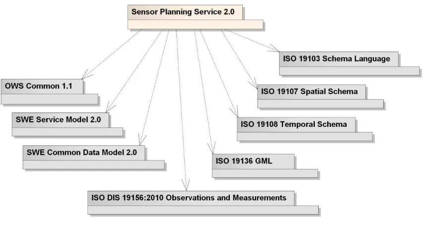
NOTE This OWS Common Specification contains a list of normative references that are also applicable to this Implementation Standard.
Copyright © 2011 Open Geospatial Consortium 5 OpenGIS® Encoding Standard, SWE Common Data Model, OGCdocument number 08-094
OpenGIS® Implementation Standard, SWE Service Model, OGCdocument number 09-001
NOTE This SWE Service Model standard contains a list of normative references that are also applicable to this Implementation Standard.
6 Copyright © 2011 Open Geospatial Consortium 4 Terms and definitions
For the purposes of this standard, the terms and definitions specified in clause 4 of [OGC 06-121r3] shall apply, as well as the terms and definitions specified in clause 4 of [09-001]. In addition, the following terms and definitions apply.
4.1 Asset
synonyms: sensor, simulation
an available means of collecting information
4.2 Asset Management System
synonyms: acquisition system, asset support system system for controlling the effective utilization of an asset
4.3 Collection
act of gathering information
NOTE In the context of SPS, the term is usually perceived having the process of gathering information in mind. Another interpretation is the aggregation of the results of one or more collection processes.
4.4 Requirement
something that is necessary in advance
4.5 Simulation
use of models to investigate time dependent processes
4.6 Task
(conceptual) resource that represents a SPS assignment. It includes the (possibly empty) set of tasking parameters.
4.7 Tasking
parameterizing an asset; can be done by sending one or more tasking requests
4.8 Tasking request
request with certain tasking semantics that contains tasking parameters
NOTE In the context of SPS, the GetFeasibility, Reserve, Submit and Update requests are tasking requests.
4.9 Tasking Parameter
Copyright © 2011 Open Geospatial Consortium 7 5 Conventions
5.1 Abbreviated terms
Most of the abbreviated terms listed in Subclause 5.1 of the OWS Common
Implementation Specification [OGC 06-121r3] apply to this document, plus the following abbreviated terms.
AOI Area Of Interest
FES Filter Encoding Specification
AM Asset Management
O&M Observation and Measurement SensorML Sensor Model Language SOS Sensor Observation Service SPS Sensor Planning Service
SWE Sensor Web Enablement
SWE Common SWE Common Data Model
SWES SWE Service Model
WCS Web Coverage Service
WMS Web Map Service
8 Copyright © 2011 Open Geospatial Consortium
5.2 UML notation
Diagrams that appear in this standard are presented using the Unified Modeling Language (UML) static structure diagram, as described in Subclause 5.2 of [OGC 06-121r3].
NOTE Packages and data types from foreign namespaces or data types from packages other than the one under consideration are shown with grey background unless they are given only as types of attributes from classes in the model defined in this specification. Interfaces are shown with light turquoise
background.
5.3 Platform-neutral and platform-specific standards
For compliance with Clause 10 of OGC Topic 12 and ISO 19119, this standard follows the pattern defined in subclause 5.4 of [OGC 06-121r3]. That is, model elements are specified in platform-neutral fashion first, using tables that serve as data dictionaries for the UML model (see clause 5.4 of this document). Platform-specific encodings of these model elements are provided in separate clauses or documents. The XML Schema encoding has automatically been generated using the rules defined in clause 24 of [OGC 09-001].
This document specifies platform-specific encodings appropriate for a SOAP/WSDL operation binding. However, the model as well as its XML Schema encoding (and other data) can be used by other bindings as well, like REST(ful) or POX (Plain Old XML) over HTTP (using XML or KVP encoding).
5.4 Data dictionary tables
The UML model data dictionary is specified herein in a series of tables. The contents of the columns in these tables are described in table 1 of [OGC 06-121r3]. The contents of these data dictionary tables are normative, including any table footnotes.
5.5 Classes imported from other specifications with predefined XML encoding
This specification uses an automatic mapping approach from the UML model to the XML Schema encoding. The approach is described in chapter 24 of [OGC 09-001]. As shown in Figure 13, this standard uses types defined by other standards. For the mapping to XML Schema, the implementation instructions listed in table D.2 of [OGC 07-036] are used together with the instructions listed in Table 2, Table 3 and Table 4 in this standard and Table 4 from [OGC 09-001].
Copyright © 2011 Open Geospatial Consortium 9 Table 2 — Implementation of types from OWS Common [OGC 06-121r3]
UML class object element type property type
AbstractMetadata ows:AbstractMetaData - -
GetCapabilities - ows:GetCapabilitiesType -
LanguageString - ows:LanguageStringType -
OWSServiceMetadata - ows:CapabilitiesBaseType -
ReferenceGroup ows:ReferenceGroup ows:ReferenceGroupType -
Table 3 — Implementation of types from SWE Common Data Model [OGC 08-094]
UML class object element type property type
AbstractDataCom
Table 4 — Implementation of types from SWE Service Model [OGC 09-001]
UML class object element type property type
10 Co
5.6 Namespace Conventions
This standard uses a number of namespace prefixes throughout; they are listed in Table 5. Note that the choice of any namespace prefix is arbitrary and not semantically significant.
Table 5 — Prefixes and Namespaces used in this standard
Prefix Namespace gml http://www.opengis.net/gml/3.2
ows http://www.opengis.net/ows/1.1 soap11 http://schemas.xmlsoap.org/soap/
soap12 http://www.w3.org/2003/05/soap-envelope swe http://www.opengis.net/swe/2.0
swes http://www.opengis.net/swes/2.0
wsa http://www.w3.org/2005/08/addressing wsn-b http://docs.oasis-open.org/wsn/b-2
xs http://www.w3.org/2001/XMLSchema
Co
6 Sensor Planning Service – Abstract Overview 6.1 Introduction
The operational context of the SPS is abstracted from, and therefore applies to, several areas of interest. In the scientific area there is a constant interplay between facts, and theories that explain the facts, which then gives rise to the need for more information in order to confirm and extend the theories. Similarly, in the medical area symptoms give rise to a need for information that calls for tests that support diagnosis. In the military area there is always a great deal that is unknown about a battle space, or about a theatre of operations other than war, which gives rise to needs for specific useful information. In the business area corporations and other non-governmental organizations have a need for global economic intelligence.
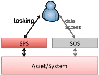
All of these areas have information needs, and the SPS is used to task assets to satisfy those needs. The SPS provides an interface to parameterize assets and asset management systems. It can be applied whenever a client is allowed to influence the internal processes of such a system. The SPS does not provide direct access to the information gathered by the system itself. This will be done via a SOS or some other (OGC) Web service. It rather serves as an interface layer to the parameterization interface of the underlying system (see Figure 2).
Figure 2 — SWE Interface of an Asset (Management System)
The SPS is an interface to a system of any complexity. The system itself is considered as a black box. In this black box, some sort of process gets executed that can be manipulated by setting specific parameters.
Example: a webcam takes pictures every minute. The SPS interface to this webcam allows modifying this time interval to anything between 10sec and 1hr.
Example: A more complex example is that of a satellite. The SPS interface allows to set a number of parameters, such as region of interest, time of interest, incidence angle with azimuth and elevation, ground resolution etc.
It is up to the SPS provider to define which parameterization options are available to clients via the SPS interface of the given service.
A system operator may even decide to have a chain of SPS instances to provide different capabilities to different types of users for the very same asset.
12 Co
Example: Consider the webcam again. Authorized users may change the looking angle and the zoom value, whereas non-authorized users can only chose between three pre-defined settings.
This concept of abstraction levels is described in more detail in section 6.5.
6.2 Client Server Interaction
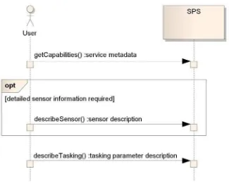
This section explains the typical interaction between an SPS client and service. The interaction starts with the GetCapabilities request to explore what the service can offer. If additional information about a sensor is required, the DescribeSensor operation is used to retrieve all available information about the sensor (see Figure 3).
Figure 3 — client server interaction part 1
Next, the client needs to learn which parameters have to be set in order to task the sensor. The client sends a DescribeTasking request and receives a DescribeTaskingResponse, which defines syntax and semantic of each tasking parameter, including choices between different parameter settings, default values, and value ranges.
Note: For complex missions, a huge number of parameters might need to be set by clients. Alternatively, the service might only provide a choice between five preconfigured missions, and then there might only be a single parameter to be set by clients, even though the missions are very complex in nature. It fully depends on the service provider to define the parameters the client shall or may set. The definition of tasking profiles is encouraged to reflect the specific requirements of different communities in a consistent way. Nevertheless, tasking parameters are encoded using SWE Common and the SPS provider should add semantic annotation to them. This allows generic SPS clients to display more specific parameter
descriptions including their semantic annotations so that a client can still meaningfully task an asset even if the client software does not provide any other support for this activity (which client software that was specifically developed to support certain tasking profiles will most probably do).
Co
After the client learned about the tasking parameters, it can choose to either submit a tasking request (Submit operation) or to perform a feasibility check (GetFeasibility operation) – see Figure 4. Both operations create – if valid and accepted – a SPS
assigment called task. Other operations allow to reserve and update a task, which will be discussed later on.
Figure 4 — client server interaction part 2
Note: Before being accepted, each tasking request is checked for feasibility by the service. Even though a tasking request has been reported previously as feasible, it does not mean that this task is still feasible at the time of submitting the task. The façaded asset might have been tasked by someone else in the meantime or became unavailable (see clause 6.3.4 for further details).
The GetFeasibilityResponse contains a StatusReport, which indicates that the tasking request is or is not feasible. Optionally, the report lists alternative sets of tasking
parameters that might help the client in formulating a tasking request that is feasible and that satisfies his information needs.
14 Co
Independent of a prior GetFeasibility request, clients always send Submit/Reserve tasking requests with all required tasking parameters to the service. There is no option to use the identifier of a previous GetFeasibility tasking request in a subsequent Submit/Reserve tasking request. This lifts the burden from the service to store all GetFeasibility request payloads.1
If a task defined by the client is submitted to the service and is feasible, it is executed by the service.
A client may reserve a task using the Reserve operation. All resources required to execute the task are blocked by the service but execution does not start until the client explicitly confirms it (via the Confirm operation) – see Figure 5.
Figure 5 — client server interaction part 3
A reservation expires at a defined point in time at which a service can reclaim all resources blocked by the reservation.
Once a task is submitted/reserved, the client can Update or Cancel it. If a service cannot reserve/execute a request as provided by the client, it can provide a list of alternative parameter settings. A client can always ask for the current status of a task / tasking request via the GetStatus operation – see Figure 6.
1 However, such behavior can be defined in an extension of this specification.
Co
Figure 6 — client server interaction part 4
The SPS responds to DescribeResultAccess requests with references to all data that was produced for a given task, even if the task was cancelled or has failed. Clients can explore the references and retrieve the data gathered for this task.
The SPS service can also send notifications including StatusReports to inform interested clients about specific events, for example that new data has been published for a task, that a task was completed or has failed. See clause 8 for further details on asynchronous notification behavior.
6.3 Task – Concept and Handling
6.3.1 Introduction
The following sections discuss relevant aspects of tasking assets via SPS. The terms task, tasking, tasking request and tasking parameter are defined in clause 4 and thus are not defined again in this section.
16 Copyright © 2011 Open Geospatial Consortium
6.3.2 Tasking Parameters
In order to parameterize an asset (management system), clients need to provide tasking parameters that influence the parameterization of the asset. Tasking parameters need to:
• describe full syntax as well as semantic of the parameter
• be extensible with metadata
• support optional parameters
• support choices between parameterization options
• support default values
• support provision of value constraints
• indicate whether the parameter can be used in a task update
The data types defined in SWE Common Data Model [OGC 08-094] satisfy these requirements and thus are used by SPS for defining tasking parameters and for encoding their values.
6.3.3 Tasking requests
To parameterize an asset, a client first has to initialize a set of tasking parameters, which constitute the task that the client is interested in getting executed by the SPS. The
definition of the tasking parameters for a given asset can be retrieved via the SPS describeTasking operation.
Then, the client has required all information to formulate and send a tasking request to the SPS. Four types of tasking request are differentiated.
• getFeasibility – to determine whether the task (remember, a tasking request contains tasking parameters) can be executed by the service or not, depending upon its current state (see clause 6.3.4). This operation can also be used to check if an update of an existing task is feasible.
• reserve – to block all resources required to execute the task (if it is feasible) for a certain amount of time; this is useful to ensure that assets from different services can be tasked together (see clause 6.3.5). The reserved task either expires or gets confirmed to be executed by the client.
• submit – to instruct the service to execute the task (if it is feasible).
• update – to update (if feasible) the tasking parameters for a task that is already reserved or in execution.
Copyright © 2011 Open Geospatial Consortium 17 However, clients may require information to be collected until a certain point in time and thus need the feasibility check to be completed some time before. Clients define this latest time when the response to a getFeasibility request must be available using the lastestResponseTime property in their request (see clause 7.3.1.3). If the service is not able to determine the feasibility of a tasking request until then, both the service and the client consider the tasking request as not feasible. This decision cannot be changed later on, i.e. any response sent by the service at a later stage is void.
A feasible tasking request means that it is accepted by the service. Depending on the request, the SPS either schedules a new task or provides a positive feasibility response without doing any further activity internally (see clause 6.3.6 for further details on state handling). Tasking in general can involve a sequence of tasking requests to have an asset gather the desired information.
Example: A client first checks the feasibility of a task (via the getFeasibility operation) – once a feasible set of tasking parameters has been determined, the task is submitted (via the submit operation) and is then updated multiple times to adjust the way the asset is gathering information. This can for example be a switch of the sampling frequency, or orientation of a remote sensor.
Clause 6.2 explained the client/server interactions for tasking an asset via the SPS in more detail.
6.3.4 Feasibility of a Task
To task a certain asset or system, tasking parameters have to be provided by the client. The definition of these parameters depends on the given asset and the parameterization abstraction level chosen by the service provider (see clause 6.5 for further information). A set of tasking parameters – or better: the set of values for these parameters – constitutes a tasking request (see clause 6.3.3). Before an SPS can accept such a tasking request, it has to check whether that task can be performed or not. This is called a feasibility check. Feasibility of a task (or tasking request) shall be checked:
• by client request, i.e. if a client needs a pre-check for an intended task.
• if a client wants to reserve a task; a reserved task can be set to operational state by the client at any time until the reservation expires. The service has to ensure the full feasibility of the task during the reservation time. Under certain conditions, the service cannot maintain the feasibility of a reserved task, e.g. if the asset was tasked by someone else with higher priority. If the service supports
publish/subscribe functionality as described in this specification then it informs the client that the reserved task has failed.
• when a task is submitted; the task can only be executed if it is feasible.
• whenever the client wants to perform an update of a reserved or submitted task.
18 Co
• syntax of tasking parameters
• presence of mandatory parameters
• validity of parameter configuration
• asset availability
• parameterization update is valid according to current execution state
The result of a feasibility check depends on the current state of the service and associated resources (e.g. the asset itself but also operators, support units, radio links, etc).
As an example, imagine a task intended to be performed during a certain interval of time by a specific asset (see Figure 7).
Figure 7 — dynamics of a feasibility study result
Client A checks the feasibility of a task to be executed in the time interval t1-t2 (1.1). The
SPS checks the internal schedule for asset X (1.2) and recognizes that the time frame is not blocked by any other task. The SPS therefore responds that the task is feasible. Before client A acts again, client B submits a task for asset X with the time interval t1-t2
(2.1). Again the SPS checks if the time frame is not already blocked by another task (2.2) and – as this is not the case – adds the task to the schedule of asset X (2.3). The time interval t1-t2 in the schedule of asset X is now blocked by the task from client B. The SPS
has accepted the submission of the task from client B and sends an according response. Now client A submits its tasking request (3.1). The SPS checks the internal schedule of asset X and recognizes that the time frame t1-t2 is already blocked by another task (from
client B). It thus rejects the submission.
Copyright © 2011 Open Geospatial Consortium 19
6.3.5 Reserving a Task
Clients can reserve tasks. This is useful e.g. if a client needs to task several assets (that are useful to him only if tasked in one go) via different services. A task can also be reserved before being submitted. Such a reservation actually represents a task for which all required resources are allocated by the service but which shall not be executed until the client confirms it.
In other words, the client puts a reserved task "on hold". This can be compared to a transaction in which the client first provides all parameterization details and finally confirms his task. The service shall check the feasibility of the task before it accepts the reservation. When the client confirms the reserved task, it is executed by the service. The confirmation does not involve an additional feasibility check by the service because a reserved task shall be feasible until it expires. If a service can no longer guarantee the feasibility of a reserved task for any reason, the reservation shall fail.
The expiration time of a reserved task is defined by the service (optionally in agreement with the expiration time the client requested), thus making sure that resources are not blocked forever. The client can cancel a reservation if the service supports the cancel operation.
A reserved task can be updated if tasking parameters are updatable (see clause 6.3.2). Each update is subject to a feasibility check by the service.
6.3.6 State Handling
This section explains in more detail how an SPS handles the states of a tasking request and a task. This is done via two state machine diagrams. A formal documentation of the diagrams is given in clause 10.
NOTE: One or more of the transitions shown in the following state diagrams are triggered by events and have a specific effect, which is to notify interested clients about the event (/Notify). A service that implements publish/subscribe functionality can inform clients about these events.
20 Co
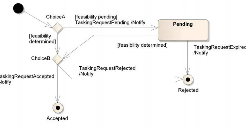
Figure 8 — tasking request state machine diagram
The decision if a tasking request is feasible or not is either directly available (feasibility determined), or requires more time (feasibility pending). The latter causes the tasking request to transition into the Pending state. If the feasibility of the (pending) tasking request cannot be determined before the request expires, then the tasking request automatically transitions from Pending into the Rejected state. Otherwise the tasking request gets back into the decision cycle: if the tasking request is feasible, then it shall be Accepted by the service – otherwise it shall be Rejected.
A task shall be scheduled by the service if the client reserved or submitted it. The following state diagram illustrates the state handling for such a task.
Co
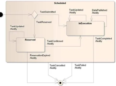
Figure 9 — task state machine diagram
Based on the user’s intention, the task automatically transitions either into the state Reserved or InExecution.
A Reserved task can be updated by the client but shall not change to state InExecution unless the client confirms it. If the client does not confirm a Reserved task before it expires, the task (automatically) transitions into the final state (category Expired). The client can update a task that is InExecution at any time. If such a task produces new data that is made available to the client, the SPS can send a notification. The task itself remains in its current state (InExecution or a substate thereof) – or more specifically: it transitions (back) into its current state.
If the task is completed it transitions into the final state (category Completed). This implies that all data gathered for the task has been published.
A client can cancel a scheduled task at any time. The task then transitions into the final state (category Cancelled).
If the server fails to complete a scheduled task as planned, then the task transitions into the final state (category Failed).
22 Copyright © 2011 Open Geospatial Consortium
6.4 Status Reporting
Status reports provide information about the status of a task and tasking request but also about the outcome of the cancellation/confirmation of a task. Status reports are contained in operation responses but are also used to encode event information, which can be published to subscribed clients.
Note: The conceptual model of a status report (see clause 7.3.1.5) is therefore quite flexible. Which features of the tasking report are used depends on the specific functionality that was invoked. This is described in detail in the according clauses.
Whenever an SPS receives a tasking request, it assigns a unique identifier to it and provides this identifier in the status report (concerning the status of the request) that is contained in the tasking response. The identifier is created even though the decision on the request may still be pending (i.e. the request is not accepted yet). Once the request gets accepted, in the case of a Submit or Reserve request a task will be scheduled. The identifier remains the same, i.e. the initially created identifier for a request now becomes an identifier for a task. This allows clients to use the identifier received with the response for subsequent requests to retrieve information about such tasks, e.g. via GetStatus.
Example: the state history of a feasible Submit request and resulting task can thus be the sequence of the states Pending
ÆAccepted/InExecution (this state can be entered more than once, e.g. when the task was updated or data was
published) ÆCompleted
Example: the state history for a feasible Reserve request can be the sequence of the states
Accepted/Reserved (the Reserved state can also be entered more than once if the reservation was updated) ÆExpired;
another possible sequence is PendingÆAccepted/ReservedÆInExecutionÆCompleted
The SPS reports the current status of a tasking request or task following the state types defined in the state machines (see clauses 6.3.6 and chapter 10). A service includes only final and non-final states. Whenever a task has reached a state, even the same state yet again (e.g. after an update the state is still inExecution) after being triggered by an event recognized by this standard (see clauses 10.1.3 and 10.2.3) or an extension of this standard, the code for this event (see clause 7.3.1.9) shall be added to the report as well. This helps clients keeping track of the current status of a task/tasking request and the reason why a certain state was (re-)entered.
By default, an SPS therefore logs the information about the latest state transition that a tasking request/task made. An SPS can also support provision of the full state history, i.e. all state transitions. This capability is indicated in the service’s metadata. If this
capability is not supported by a service instance then such a service can discard
information about all state transitions of a task/tasking request except for the latest one. In any case, an SPS is only obliged to provide status information for a certain period of time after a tasking request/task was finalized. How long exactly this period is depends on the given service instance.
6.5 Levels of Abstraction – SPS Chains
The functionality offered to a client through the SPS by the asset owner can range from full blown, detailed parameterization options to just a small set of very abstract
Co
layers can be put in place to make tasking more intuitive for end users – thereby hiding system complexity – while still allowing experts to take advantage of the full set of parameterization options (see following figure).
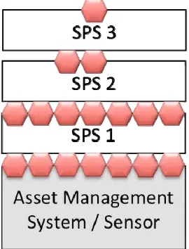
Figure 10 — tasking on various abstraction levels
The figure above shows an example of an asset management system (or a concrete sensor), which has a number of SPS instances assigned to it. The system has a number of parameters to be set (red hexagons). In order to task the system, all parameters have to be defined, which is handled by the first SPS instance (SPS 1). The abstraction interface on top (SPS 2) only shows two parameters and a second abstraction interface (SPS 3) shows a single parameter only.
As an example for such an SPS chain, imagine a satellite control system. The system itself requires the parameters region of interest, time of interest, min/max of azimuth and elevation as well as coverage type to be set. The base SPS interface therefore describes seven tasking parameters. At the next abstraction level, the clients can only define region of interest, time of interest and coverage type. The SPS instance at that level will take care for the missing parameters azimuth and elevation. At the highest abstraction level, the SPS interface describes only a single parameter: region of interest. Thus, clients cannot define the time of interest or any of the other parameters, but need to accept what is offered by the service. The different SPS instances simply forward the information provided by a client from the highest level to the asset management system and define the missing parameters with their own data. Clients are usually not aware of this “request enrichment”; it is opaque to them.
The same chain of SPS instances is conceivable for different types of SPS, like simulation systems, processing systems, fusion systems and real physical assets.
6.6 Asynchronous Communication
The Sensor Planning Service interface often facades complex asset management systems that do not provide an immediate response to operation requests or which need a long time to gather needed information. The former can be due to the fact that the request has
24 Copyright © 2011 Open Geospatial Consortium to be analyzed first, which might be a time consuming task. The latter can be due to the fact that the asset – for example a reconnaissance drone or satellite – is not located above the area of interest and therefore has to be moved there, first. Another example is to have the service itself inform the client about a situation of interest. In either case, this shows that the SPS needs to have functionality to support an asynchronous interaction pattern.
6.7 Information Access
Copyright © 2011 Open Geospatial Consortium 25 7 Sensor Planning Service – Implementation Model
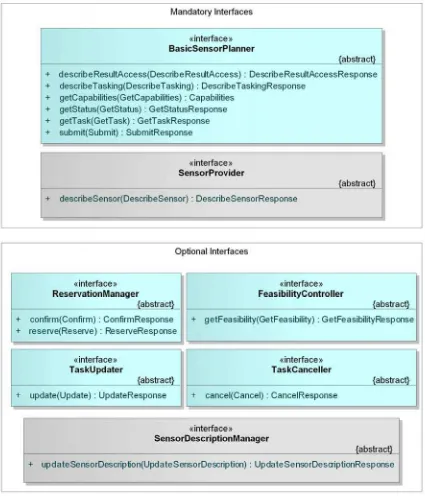
7.1 Interface Overview
The SPS operations can be divided into informational and functional operations. The informational operations include GetCapabilities, DescribeTasking,
DescribeResultAccess, GetTask and GetStatus operation. The functional operations are the GetFeasibility, Reserve, Confirm, Submit, Update and Cancel operations. All functional operations have an effect on the asset management system.
26 Co
Figure 11 — SPS interfaces UML diagram
NOTE In this UML diagram, the request and response for each operation is shown as a single
parameter that is a data structure containing multiple lower-level parameters. These structures are discussed in subsequent clauses. The UML classes modeling these data structures are included in the following clauses.