Approval Date: 2013-06-22
Posted Date: 2013-02-28
Reference URL for this document: http://www.opengis.net/doc/BP/obs-via-sos/1.0
Reference number of this OGC® project document: OGC 13-015 Version: 1.0
Category: OGC® Best Practices Editor: EO2HEAVEN Consortium
OGC Best Practice for Sensor Web Enablement:
Provision of Observations through an
OGC Sensor Observation Service (SOS)
Copyright notice
See Copyright statement on next page
To obtain additional rights of use, visit http://www.opengeospatial.org/legal/.
Warning
This document defines an OGC Best Practices on a particular technology or approach
relat-ed to an OGC standard. This document is not an OGC Standard and may not be referrrelat-ed to
as an OGC Standard. It is subject to change without notice. However, this document is an
of-ficial position of the OGC membership on this particular technology topic
.
Document type: OGC® Best Practice Document subtype:
Copyright © 2013, EO2HEAVEN Consortium
The EO2HEAVEN
Consortium (
http://www.eo2heaven.org/
) grants third parties the right to use
and distribute all or parts of this document, provided that the EO2HEAVEN project and the
docu-ment are properly referenced.
ment: Provision of Observations through an OGC Sensor
Ob-servation Service (SOS)"
An important aspect in order to improve the applicability of the Sensor Web technology to
applica-tion domains such as environment and health is to facilitate the practical use of the OGC Sensor
Web Enablement (SWE) framework. This document reflects experiences and recommendations
when using OGC SWE concepts in the research project EO2HEAVEN (Earth Observation and
En-vironmental Modelling for the Mitigation of Health Risks), co-funded by the European Commission
as part of the 7th Framework Programme (FP7) Environmental theme. EO2HEAVEN contributes to
a better understanding of the complex relationships between environmental changes and their
im-pact on human health.
This document focuses on one basic issue: the provision of observations in an OGC SOS.
This includes the definition of a lightweight profile of the OGC Sensor Observation Service (SOS),
an analysis of and contribution to the specification of the SOS 2.0 as well as an approach how the
data used within Earth observation (EO) applications can be integrated more easily into SOS
in-stances. It focuses on sensor data (observations) originating mainly from in-situ or mobile sensors
providing measurements that may be mapped to a tabular format.
The intended audience of this document includes system architects, information modelers and
sys-tem developers engaged in designing sensor service networks and related applications taking into
account relevant OGC standards.
For more details on EO2HEAVEN see the project Web site at
http://www.eo2heaven.org
. The
es-sence of this document relies upon the contents of the EO2HEAVEN public deliverable D4.8
“Specification of Advanced SWE Concepts”. For further EO2HEAVEN specifications see
http://www.eo2heaven.org/category/documents-categories/public-deliverables
.
1
SEVENTH FRAMEWORK PROGRAMME
THEME 6
ENVIRONMENT (INCLUDING CLIMATE CHANGE)
EO2HEAVEN
Earth Observation and ENVironmental modelling
for the mitigation of HEAlth risks
244100 - EO2HEAVEN CP-IP
OGC Best Practices for Sensor Web Enablement:
Provision of Observations through an OGC Sensor
Observation Service (SOS)"
March 2012
The research leading to these results has received funding from the European Community's Seventh Framework Programme (FP7/2007-2013)
2
Document Control Page
Title OGC Best Practices for Sensor Web Enablement: Provision of Observa-tions through an OGC Sensor Observation Service (SOS)
Creator Ed.: Thomas Usländer (Fraunhofer IOSB)
Description This document comprises experiences and recommendations when
us-ing Sensor Web Enablement (SWE) concepts. This document focuses on one basic issue: the provision of observations in an OGC SOS.
This includes the definition of a lightweight OGC SOS profile (OGC 11-169r1), an analysis of and contribution to the specification of the Sensor Observation Service (SOS) 2.0 as well as an approach how the data used within Earth observation (EO) applications can be integrated more easily into SOS instances.
These recommendations result from the work performed in 2010-2013 as part of the research project EO2HEAVEN (Earth Observation and
Environmental Modelling for the Mitigation of Health Risks), co-funded by the European Commission as part of the 7th Framework Programme (FP7) Environmental theme. EO2HEAVEN contributes to a better under-standing of the complex relationships between environmental changes and their impact on human health. See http://www.eo2heaven.org/ . The lightweight OGC SOS profile has been developed in close coopera-tion between the FP7 projects EO2HEAVEN and UncertWeb (see
http://www.uncertweb.org/ ).
Publisher EO2HEAVEN Consortium
Contributors Bröring, Arne (52°North)
Hollmann, Carsten (52°North)
Stasch, Christoph (IfGI, University of Münster, on behalf of the Un-certWeb project)
Usländer, Thomas (Fraunhofer IOSB) Watson, Kym (Fraunhofer IOSB)
Type Text
Format Microsoft Word 2003
Language en-GB
Creation date 08/01/2013
Version number 1.0
Version date 27/02/2013
3
Revision history
Version Date Modified by Comments
0.1 08/01/2013 Usländer, Thomas (Fraunhofer IOSB) Initial version.
0.2 01/02/2013 Usländer, Thomas (Fraunhofer IOSB) Draft based upon input from part-ners
0.3 06/02/2013 Usländer, Thomas (Fraunhofer IOSB) Consolidated Draft
0.4 07/02/2013 Jirka, Simon (52°North) Proofreading and minor revision. 0.5 11/02/2013 Usländer, Thomas (Fraunhofer IOSB) Consolidated Draft
1.0 27/02/2013 Usländer, Thomas (Fraunhofer IOSB) Jirka, Simon (52°North)
Stasch, Christoph (IfGI, University of Münster)
Update of Annex A: OGC SOS lightweight profile (OGC 11-169r1)
4
Table of Contents
1
Architectural Context ... 7
2
Provision of Observations ... 8
2.1
Sensor Observation Service (SOS) Version 2.0 ... 8
2.1.1
Introduction ... 8
2.1.2
Challenges and Questions Addressed by the SOS 2.0 Standard ... 8
2.1.3
Summary of the SOS 2.0 Specification ... 9
2.1.4
Summary and Conclusion ... 10
2.2
Lightweight SOS Profile ... 11
2.2.1
Introduction ... 11
2.2.2
Challenges and Questions ... 11
2.2.3
Results ... 11
2.2.4
Conclusion ... 15
2.3
Import of Sensor Data Archives into the SOS ... 16
2.3.1
Introduction ... 16
2.3.2
Challenges and Questions ... 16
2.3.3
Results ... 16
2.3.4
Summary and Conclusion ... 32
3
References ... 33
4
Abbreviations and acronyms ... 35
5
Index of figures
Figure 2-1: Choosing a CSV file on the local file system containing the observation data ... 19
Figure 0-2: Choosing a CSV file on a FTP server ... 20
Figure 0-3: Selecting settings for parsing the CSV file ... 21
Figure 0-4: Describing the content of the columns (date and time) ... 22
Figure 0-5: Describing the content of the columns (measured value) ... 23
Figure 0-6: Creating associations between measured values and features of interest ... 24
Figure 0-7: Adding missing metadata (missing time zone) ... 25
Figure 0-8: Adding missing position information (EPSG code and height) ... 25
Figure 0-9: Automatically generating feature of interest identifiers ... 26
Figure 0-10: Manually adding information about the unit of measurement ... 27
Figure 0-11: Creating sensor identifiers ... 28
Figure 0-12: Setting the positions of the features of interest through a map view ... 29
Figure 0-13: Setting the positions of the features of interest through text fields ... 30
Figure 0-14: Setting the URL of a Sensor Observation Service ... 31
6
Index of Tables
Table 1 Supported Observation Types of the Lightweight SOS Profile ... 13
Table 2 Different steps of the application ... 18
7
1
Architectural Context
The OGC Sensor Web Enablement (SWE) architecture (OGC, 2008c) defines a conceptual approach to build a Spatial Data Infrastructure (SDI) for sensor data. This architecture provides the conceptual foundation and standard framework of the work presented in this document.
In addition to the OGC SWE architecture, the present recommendations and tools rely upon the archi-tectural work that has been carried out in a series of European research projects and submitted to OGC as best-practices work follows:
Reference Model of the ORCHESTRA Architecture (RM-OA) (OGC, 2007c), accepted as OGC best-practices paper in 2007, that instantiated and tailored the OGC Reference Model for the domain of environmental risk management following the ISO Reference Model for Open Dis-tributed Processing (RM-ODP) (ISO/IEC 10746-1:1998), and
the Sensor Service Architecture (SensorSA) (OGC, 2009d), accepted as OGC discussion pa-per in 2009, that extended the RM-OA towards a sensor-based environment following the OGC SWE architecture.
8
2
Provision of Observations
This paper provides recommendations on the provision of observation data in a consistent way. It co-vers the following three main aspects:
1. In section 2.1 the OGC Sensor Observation Service (SOS) 2.0 (OGC, 2012a) standard is intro-duced as a web service interface offering interoperable access to sensor data. The emphasis in this section is put on the specific advancements of the SOS 2.0 compared to version 1.0. 2. In order to facilitate the application of the SOS 2.0 standard, section 2.2 recommends a
light-weight SOS profile for stationary in-situ sensors that focuses on the SOS core elements. 3. Finally, section 2.3 introduces an approach how data owners can easily publish their data on
SOS servers through a graphical import tool.
2.1 Sensor Observation Service (SOS) Version 2.0
2.1.1 Introduction
Standardized access to sensor observations and sensor metadata is provided by the OGC SOS. Ob-servations offered by the SOS can be collected by physical or virtual sensors (e.g. simulations or re-sults of model calculations). The service acts as a mediator between a client and the sensor data ar-chive or a physical sensor system. The heterogeneous communication protocols and data formats of the associated sensors are hidden by the standardized interface of the SOS. Sensor data requested by a client are returned as observations following the structure of the Observations and Measurements (O&M) model (ISO 19156:2011). The interface of the SOS supports access to heterogeneous sensor types, stationary as well as mobile sensors which gather their data in-situ or remotely.
2.1.2 Challenges and Questions Addressed by the SOS 2.0 Standard
This paper recommends the use of the SOS 2.0 (OGC, 2012a) as it is an evolutionary improvement of the SOS 1.0 standard. Based on the experiences gained with the SOS 1.0 specification (OGC, 2007a) the SOS 2.0 standard addresses several challenges. These are summarized as follows and described in more detail in the following sub-section:
Complexity reduction
o Division into core, extensions, and requirements (classes)
o Introduction of a key-value-pair (KVP) binding
o Definition of O&M as default and mandatory response format for observations
Capabilities redesign
o One sensor per observation offering to uniquely describe relationships between sen-sors, observed properties, and features
o New section: InsertionCapabilities for providing all metadata necessary for inserting new sensors and observations
o Features of Interest are not listed in Contents anymore to reduce the length of the GetCapabilities responses
Result handling redesign
o New operations: InsertResult and InsertResultTemplate
o New operation: GetResultTemplate
9
2.1.3 Summary of the SOS 2.0 Specification
The development of the final version of the SOS 2.0 specification was completed in 2012 and the final standard document was published in the same year (OGC, 2012a).
The main advancements from SOS 1.0 to SOS 2.0 are described in the following.
Complexity Reduction
A central goal of the development of SOS 2.0 has been the reduction of complexity of the standard to facilitate its application in software development. In this respect and by aiming at a better readability of the specification document, SOS 2.0 divides its operations and functionalities into a specification core and its extensions. The core comprises the mandatory operations for retrieval of the service metadata and its content (GetCapabilities), for querying observations (GetObservation), and for accessing sensor descriptions (DescribeSensor). The transactional extension contains operations for inserting new sen-sor descriptions and sensen-sor observations. The result handling extension specifies operations for inser-tion and retrieval of pure observainser-tion results without observainser-tion metadata to increase performance and scalability. The enhanced extension amends the SOS functionality by providing optional operations, e.g. to enable the retrieval of observed features. By following OGC’s new modular specification model (OGC 2009a) the core and extensions of the SOS 2.0 specification consist of requirement classes con-taining requirements, which convey criteria to be fulfilled if compliance with the standard is claimed. This new design of the specification is more precise and facilitates conformance testing of compliant software components.
In order to facilitate the usage of the SOS, version 2.0 of the standard adds an http GET binding for se-lected operations. The operation parameters are passed to the service as key-value pairs in the URL of the service endpoint. This binding is reduced in complexity, but also in functionality, compared to the usual XML-based SOAP binding and simplifies the usage of the SOS. In the future, also a RESTful SOS binding would be desirable as mentioned in section 2.2.
The SOS 1.0 specification did not define any response format as mandatorily supported. To restrict this generality and eventually improve interoperability the SOS 2.0 standard defines O&M as its mandatory and default response format for sensor data. Other response formats may still be supported by SOS servers. However, a formally accepted extension of the standard has to define how the service behaves in detail when responding in that format. The SOS 2.0 interface still does not define a default and man-datory response format for the retrieval of sensor metadata. However, SensorML (OGC, 2012b) is men-tioned as the recommended format. The Transducer Markup Language (TML), named in the SOS 1.0 specification document as a potential response format, is not mentioned in the specification anymore. This decreases the options and increases interoperability among SOS 2.0 servers.
Capabilities redesign
A step towards simplifying the standard and streamlining the different SWE services is the introduction of the SWE Common specification (OGC 2008b) upon which the SOS 2.0 specification is based. A main part of that specification is the description of a common, SWE-wide model for the part of the self-describing metadata document of a service, also known as capabilities document, which describes the content of a SWE service. For this contents section of the capabilities document, abstract types are de-fined and reused by the SOS 2.0.
Note: Other SWE services such as the Sensor Planning Service (SPS) 2.0 (OGC, 2009c) rely upon the SWE Common specification as well.
10
An important concept within the SWE framework defined by the O&M model is the feature of interest. A feature of interest is the computational representation of a real-world entity modeled with a certain set of properties. This could be for example the feature “Gulf of Mexico”. Also, a sampling point “P_42” within the Gulf of Mexico, where a measurement was taken by a certain (maybe mobile) sensor system, is a feature of interest. Both could have properties such as water depth, salinity or geometry. In case of the SOS 1.0 standard all features of interest of the aggregated observations needed to be listed for each observation offering. This is helpful to provide clients a list of features for which observations can be requested. However, this listing of all features has been identified as a problem for mobile sensor systems (e.g., a boat taking measurements in the Gulf of Mexico), which create many sampling fea-tures (e.g., sampling points) during operation. Those sampling feafea-tures could accumulate to huge num-bers and could increase the capabilities document up to an unusable size. Hence, SOS 2.0 servers do not list sampling features of interest in their capabilities document anymore. Instead, only those fea-tures of interest shall be listed to which the sampling feafea-tures belong to. In the example above, this would be “Gulf of Mexico” and not “P_42”. Listing those sampled features of interest supports the dis-covery of observations.
Result handling redesign
The SOS 1.0 standard has already supported the retrieval of the pure observation results for a specified timestamp without the complete set of associated observation metadata. The purpose of this functional-ity is to allow clients to repeatedly obtain sensor data without receiving responses that largely contain the same data except for a new timestamp and result value. This is in particular useful in scenarios with restricted bandwidth or for SOS clients with restricted processing power. The SOS 2.0 specification re-designs and simplifies the GetResult operation involved in this retrieval of pure observations results. In particular, the response from the SOS server containing the results is defined in a more precise way. An additional operation is introduced (GetResultTemplate) which returns an exact description of the structure and the encoding of the results by making use of the SWE Service Common 2.0 data model. A functionality added by the SOS 2.0 standard is the insertion of pure observation results by means of new operations (InsertResultTemplate and InsertResult). These allow client components to insert sen-sor results into an SOS without the need to repeatedly transmit the entire set of observation metadata. Similar to the result retrieval functionality, this functionality is useful if the communication bandwidth of the client, in this case the sensor data producer, is limited.
Also, the capabilities model of the SOS 2.0 has been improved to better support the insertion of new data to SOS servers. A new section of the capabilities document (called insertion capabilities section) now states the observation type, result type, feature types, and encodings supported by a SOS server for insertion of results or observations.
Advanced feature retrieval
However, clients still need to be able to retrieve a list of sampling features from the SOS. The knowledge about existing sampling features is, for example, necessary for the construction of queries for sensor observations. For the retrieval of features of interest a separate operation, called GetFea-tureOfInterest, has already been defined in the SOS 1.0 specification. In version 2.0 of the SOS stand-ard this operation is extended in its parameterization. Not only a specific feature, or features for a cer-tain spatial filter can be requested, also features which are observed by specified sensors or which car-ry specified observed properties can be requested. And further, SOS 2.0 servers allow the clients to re-quest all stored features of interest.
2.1.4 Summary and Conclusion
11
2.2 Lightweight SOS Profile
2.2.1 Introduction
The Sensor Observation Service (SOS), in its version 1 (OGC, 2007a) and in its version 2 (OGC, 2012) as assessed in section 2.1, plays a central role in the OGC SWE architecture as it defines an interface for accessing sensor data and metadata.
However, the SOS specification and the most important additional standards it relies on, are relatively complex to implement and use. These encompass the Observations and Measurements (O&M) specifi-cation for conceptualizing (ISO 19156:2011) and encoding measurement data (OGC, 2011a) as well as the Sensor Model Language (SensorML) (OGC, 2007b) for encoding metadata,
The reason for this is the extremely broad range of applications that these standards are supposed to support. On the one hand, this makes it possible to flexibly apply SWE to many different applications, on the other hand, the effort for understanding, implementing and applying the SWE standards increas-es considerably.
This section introduces an approach for a lightweight profile of the SOS by focusing on a set of com-monly used elements of these standards and thus reducing the complexity of the specification.
At a later stage this work may serve as a basis for developing domain-specific SWE profiles.
2.2.2 Challenges and Questions
This profile was designed in a way that is, on the one hand, efficient and easy to implement, and, on the other hand, standard compliant. Especially the following challenges were considered during the crea-tion of the profile:
Reducing the number of operations: certain operations of the SOS standard were designed for very specific needs; these operations were left out of this profile
Reducing the complexity of the SOS operations (e.g. less complex filters for requesting sensor data)
Limiting the supported data formats to those used in practice (i.e. no support of the Transducer Markup Language (TML) within the SOS)
In summary, the main aim that guided the development of this profile was
to support those use cases which are regularly occurring in practice, and
to leave out those with very specific requirements that go beyond the mainstream of SWE use cases.
In the next section, it is described how a lightweight profile of the SOS may look like. The profile de-scribed in this best practices paper is based on the 2.0 versions of the different SWE specifications. A more detailed description of this profile is attached as Annex A to this document and can also be found in (OGC, 2011b).
2.2.3 Results
The OGC SOS defines standardized interfaces for accessing sensor data and metadata. Thus, the SOS may be considered as the core element of the SWE architecture. It provides a means for integrat-ing sensor data into Spatial Data Infrastructures like it is already possible for other kinds of geospatial data such as maps (through the OGC Web Map Service (WMS, OGC 2006), raster data (through the OGC Web Coverage Service (WCS, OGC 2008a) and geospatial objects (through the OGC Web Fea-ture Service (WFS)).
12
2.2.3.1 SOS Operations
This lightweight SOS profile comprises those operations, which are mandatory within the SOS standard (GetCapabilities, DescribeSensor and GetObservation) so that they shall be implemented by every standard compliant SOS server. Furthermore, the GetFeatureOfInterest operation was included as it al-lows accessing the geometries of sensor stations.
The GetCapabilities operation is common for every OGC web service specification. It is important to support this operation as it provides the metadata necessary for clients to generate valid SOS requests. It contains especially the following information:
Supported operations of the SOS instance
Identifiers of all sensors encapsulated by the SOS instance
Identifiers of all observed phenomena
Offerings
Note: As described in section 2.1.3, the SOS 2.0 standard requires a unique relationships be-tween exactly one sensor and its observed phenomena.
The DescribeSensor operation allows the client to retrieve metadata about the sensors encapsulated by an SOS instance. It is a mandatory element of the SOS specification. Thus, it is included in the mini-mum profile so that servers must offer this operation. However, clients need not necessarily make use of the DescribeSensor operation. The request of the DescribeSensor operation is very simple as the only parameter consists of the identifier of the sensor for which a metadata document is requested. The response is a SensorML document (a simple structure for such a SensorML document is defined below in section 2.2.3.3).
The GetObservation operation is an essential part of the SOS specification as it is the operation for re-questing sensor data. Thus, it is obvious that this operation is needed for both servers and clients. However, in order to reduce the complexity of the GetObservation operation several restrictions have been defined that limit the query parameters. In detail the following parameters are included in this lightweight SOS profile:
Offering: the identifier of the offering that contains the requested sensor data
Temporal filter for specifying the time for which sensor data is requested; however the temporal filters are limited within the lightweight SOS profile to the following types: during a time period and equal to a time instant
Procedure: the identifiers of the sensors from which data is requested
Observed property: the identifier of the phenomena for which data is requested
Feature of interest: the geometry object for which data is requested; within the lightweight SOS profile this is limited to identifiers of the geometric objects for which sensor data is requested
Spatial filter: Bounding box of an area for which data is requested
The GetFeatureOfInterest operation allows retrieving the geometries of the stations at which measure-ments were performed. As the access to the geometries of measuremeasure-ments is a requirement for creating map visualizations of the sensors and their data, the GetFeatureOfInterest operation has been included for servers in this lightweight SOS profile. However, not every client might rely on this operation (e.g. clients that only show diagrams of time series data). In order to reduce the complexity of this operation, its request parameters are restricted within this profile. Clients may request geometries using only one of these parameters:
featureOfInterest: the identifier of the requested feature of interest
spatialFilter: bounding box describing an area for which features are requested
13
procedure: identifiers of the procedures that shall observe the requested features
In case of this profile, the response of the GetFeatureOfInterest operation shall always contain one or more SamplingPoints.
2.2.3.2 Observations and Measurements
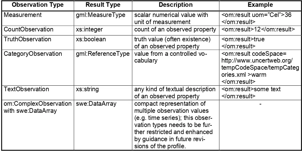
The Observations and Measurements standard offers an encoding for data observed by sensors. How-ever, as O&M has been designed to be extremely versatile and comprehensive it has also a certain complexity. Thus, this lightweight profile has been defined containing only those elements of O&M, which are essential for most common use cases. Within the lightweight SOS profile, the following ob-servation types are included:
Observation Type Result Type Description Example
Measurement gml:MeasureType scalar numerical value with unit of measurement
<om:result uom=”Cel”>36 </om:result>
CountObservation xs:integer count of an observed property <om:result>12</om:result> TruthObservation xs:boolean truth value (often existence)
of an observed property
<om:result>true </om:result> CategoryObservation gml:ReferenceType value from a controlled
vo-cabulary TextObservation xs:string any kind of textual description
of an observed property
<om:result>some text </om:result>
om:ComplexObservation with swe:DataArray
swe:DataArray compact representation of multiple observation values (e.g. time series); this obser-vation types needs to be fur-ther restricted and enhanced by guidance in future revi-sions of the profile.
-
Table 1 Supported Observation Types of the Lightweight SOS Profile
Note: Table 1 is taken from the OGC Discussion Paper (OGC, 2011b) and has been slightly enhanced (addition of SWE Common Observations)
In order to minimize the complexity of O&M documents, the responses of SOS servers need only to contain a limited set of O&M elements. These are:
gml:identifier (mandatory): this element shall be provided for uniquely identifying or referring to a specific observation.
om:phenomenonTime (mandatory): the time instant or time period for which the observation contains sensor data; within the lightweight profile this is restricted to the data types TimeIn-stant and TimePeriod.
om:resultTime (mandatory): the time when the result became available.
om:procedure (mandatory): the identifier of the sensor that has generated the observation
om:observedProperty (mandatory): the identifier of the phenomenon that was observed
14
points
om:result (mandatory): the observed value; the type of the result is restricted to the types shown in Table 1.
A typical sensor observation encoded using an om:Measurement looks as follows:
<?xml version="1.0" encoding="UTF-8"?>
<!--============================================================= This observation depicts an example
-point as sampling location -time instant as phenomenon time
-result is a measure value (double with units of measure information) ==============================================================-->
<om:OM_Measurement gml:id="obsTest1" xmlns:om="http://www.opengis.net/om/2.0"
xmlns:xsi="http://www.w3.org/2001/XMLSchema-instance"
xmlns:sams="http://www.opengis.net/samplingSpatial/2.0"
xmlns:sf="http://www.opengis.net/sampling/2.0"
xmlns:xlink="http://www.w3.org/1999/xlink"
xmlns:gml="http://www.opengis.net/gml/3.2"
xsi:schemaLocation="http://www.opengis.net/om/2.0 ../observation.xsd">
<!--============================================================= global identifier of the observation
==============================================================-->
<gml:identifier codeSpace="http://www.myWebSite.org">obsTest1</gml:identifier>
<!--=============================================================
phenomenon time represents the time when the observation was taken (so when the sensor has interacted with reality
==============================================================-->
<om:phenomenonTime>
<gml:TimeInstant gml:id="ot1t">
<gml:timePosition>2005-01-11T16:22:25.00</gml:timePosition>
</gml:TimeInstant>
</om:phenomenonTime>
<!--=============================================================
result time represents the time when the result value was produced; might differ for example in case of a soil sample; sample has been taken during phenomenonTime and then evaluate later in a laboratory during resultTime
==============================================================-->
<om:resultTime xlink:href="#ot1t"/>
<!--============================================================= procedure has produced the observation's result (usually a sensor) ==============================================================-->
<om:procedure xlink:href="http://www.example.org/register/process/scales34.xml"/>
<!--=============================================================
observedProperty usually contains a link to a vocabulary containing the definition of the property which has been observed; in case of environmental modelling this is usually a physical phenomenon (e.g. temperature, air pollutant concentration, etc.)
==============================================================-->
<om:observedProperty xlink:href="urn:ogc:def:phenomenon:OGC:temperature"/>
<!--============================================================= feature of interest carries the sampling geometry of the observation ==============================================================-->
<om:featureOfInterest>
<sams:SF_SpatialSamplingFeature gml:id="SamplingPoint1">
<sf:type xlink:href="http://www.opengis.net/def/samplingFeatureType/OGC-
15
</sams:shape>
</sams:SF_SpatialSamplingFeature>
</om:featureOfInterest>
<!--=============================================================
observation result is an numerical value with information about the unit of measurements
==============================================================-->
<om:result uom="Cel">36</om:result> </om:OM_Measurement>
2.2.3.3 Sensor Model Language
The Sensor Model Language (SensorML) is used within the SOS for encoding the sensor metadata documents that are returned in case of DescribeSensor requests.
This lightweight profile defines a minimum set of metadata that shall be provided in a SensorML docu-ment. Complex elements of SensorML that are intended for very specific applications are not consid-ered within this lightweight profile but may be added if necessary.
The following metadata items are considered mandatory for a SensorML document:
gml:description: A short textual description of the sensor or sensor system
gml:identifier: A unique identifier of the sensor system
sml:keywords: Terms which help to describe the sensor system and serve for discovery pur-poses (e.g. observed phenomena, name of the sensor location)
sml:identification: A short and a long name referring to the sensor system
sml:classification: At least a classifier identifying the sensor type
sml:contacts: Contact information about the operator of the sensor
sml:featuresOfInterest: abstraction of the real world entity, the feature of interest, which is ob-served by the sensor system. In case of this profile, the feature of interest is a station and mod-elled as a SamplingPoint.
The outputs of the sensors (identifiers of the observed phenomena and if necessary the units of measurement)
A further restriction is that every sensor shall be modelled as a SensorML system. Other types are not considered for this profile.
2.2.4 Conclusion
In summary this section has provided a pragmatic approach how the complexity of the SOS, O&M and SensorML standards can be reduced by defining according minimum profiles. This makes it easier to apply SWE concepts more quickly and with less overhead for familiarizing with the specifications. Alt-hough these minimum profiles reduce the flexibility of these standards, we expect that most common applications can be covered by these profiles.
16
2.3 Import of Sensor Data Archives into the SOS
2.3.1 Introduction
Within various projects and initiatives many existing (sensor) datasets are used which cover time peri-ods in the past. However, these datasets are currently only available in form of existing files (e.g. com-ma separated values) or local databases. In order to integrate these datasets into systems which com-make use of distributed SDI components, it is necessary to provide the existing sensor data though standard-ized web-based interfaces, i.e. the OGC Sensor Observation Service (SOS) (OGC, 2007a and OGC, 2012). The following section investigates how the import of these sensor data archives into SOS in-stances may be facilitated to turn into a task manageable for non-IT experts.
The current implementation of the SOS Import tool was developed in the course of the EO2HEAVEN project and is available online at: https://wiki.52north.org/bin/view/SensorWeb/SosImporter
2.3.2 Challenges and Questions
Currently, a significant amount of knowledge is required when setting up an SOS instance filled by ex-isting sensor data. Usually the users have three options for publishing their sensor data:
Usage of the transactional SOS operations: In this case the user has to convert the data into the Observations and Measurements (O&M) data model (ISO 19156:2011 and OGC, 2011a) such that the data can be inserted into the SOS instance through standardized operations. However, a domain expert should not be obliged to spend the effort to understand the O&M model before being able to map the existing sensor data to the O&M model.
Direct insertion of sensor data into SOS databases: In this case the existing data is transmitted into the database of the SOS, e.g. by means of SQL statements in case of a relational data-base. However, this approach is neither suitable for non-IT-experts. Users should not be obliged to spend time to understand the data model of a proprietary SOS database, familiarize with SQL and create according SQL statements.
Note: The data model of the database “behind” the SOS interface is not standardized.
Connection of existing databases with SOS instances: In this case a SOS implementation would be customized in order to use a specific database as source for observation data. But as this approach would require significant programming work, it is not suited to non-IT-experts as well.
The following section describes an approach that facilitates the import of sensor data into SOS instanc-es. The envisaged solution is a wizard tool that guides users through the import process of sensor data. The users are able to describe the structure of the existing data through a graphical user interface such that the wizard is able to automatically create a mapping of the existing datasets into the SOS/O&M/SensorML data models, respectively.
After specifying the structure of the datasets, the wizard pushes the sensor data into the SOS instance in a final step.
2.3.3 Results
The current version relies upon comma-separated values (CSV) files as the input for the application. CSV files are a common approach to represent tabular data in a textual format. Outside the Sensor Web, they are often used to exchange sensor data. The structure of CSV files has never been stand-ardized, though there are some guidelines (Shafranovich, 2005):
Columns are separated with a consistent character and rows are separated with newlines.
17
In countries where decimal numbers are already separated with commas, other characters, like the semicolon or colon, are taken.
Fields that contain a special character (e.g. a column separator or a newline) are enclosed by two quote symbols.
Often, double quotes are used here. If a field includes a quote symbol, it is escaped by placing another quote symbol in front (e.g. “”best“” for “best”).
Sometimes, comment characters (e.g. #) may appear which escape a whole line.
It is assumed that the content of the CSV file, measurements and sensor metadata, is stored column-wisely. For example, it could look like this:
01.01.2011; Sensor1; 1,3 01.01.2011; Sensor2; 2,5 02.01.2011; Sensor1; 1,7 02.01.2011; Sensor2; 2,2 …
At least one column of measurements should be included in the file. The results of measurements can be numeric, positive integers (counts), Booleans (true or false) or textual. For numeric values (e.g. 2.3), thousands and decimal marks have to be specified in addition. This is necessary since regional differ-ences exist for these separators. For example, in Germany a decimal comma is used, whereas the United Kingdom and the United States use a decimal point.
In addition to the measurement column, there can be one or more date and time column in arbitrary format. Date and time could be split over several columns (e.g. date in one, time in another one). More-over, date and time need not be complete to be compliant to OGC SWE standards. For instance, there are only times and no dates, or the time zone is missing. Analogously, this applies to sensor locations, too, in case they were provided within a CSV file. The format in which sensor positions are described can be arbitrary, so patterns for converting them into a standardized positional scheme have to be specified. Position data could be available partitioned in several columns (e.g. latitude in one, longitude in the other one) and, again, need not be complete. For example, only latitude and longitude are given and neither height, nor a spatial reference system. Also, the units of latitude, longitude and height might be missing.
It is assumed that within one column the same format is used (e.g. comma as a decimal separator or throughout the same date and time pattern). Other values than these (e.g. NULL-values or headings) will be ignored. Further columns in the CSV file might include units of measure, observed properties, sensors or features of interest. It is not very likely that URIs can be found here, so these columns will be interpreted as names. In the scope of the work described in this document, only stationary (not mobile) and in-situ (not remote) sensors are taken into account.
18
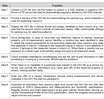
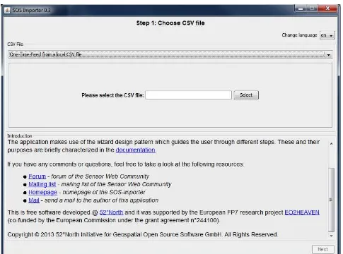
Step Function
Step 1 Choose a CSV file from the file system to publish in a SOS instance or specify a CSV file on a FTP server that shall be (automatically/regularly) fetched by the SOS importer. Step 2 Provide a preview of the CSV file and select settings for parsing (e.g. which character is
used for separating columns)
Step 3 Display the CSV file in tabular format and assign metadata to each column (e.g. indi-cate that the second column consists of measured values). Offer customizable settings for parsing (e.g. for date/time patterns)
Step 4 Solve ambiguities: In case of more than one date/time, feature of interest, observed property, unit of measurement, sensor identifier or position has been identified in step 3, select the correct associations to the according measured value columns (e.g. state that date/time in column 1 belongs to the measured values in column 3 and date/time in column 2 belongs to the measured values in column 4). When there is exactly one ap-pearance of a certain type, automatically assign this type to all measured values
Step 5 Check available metadata for completeness and ask the user to add information in case something is missing (e.g. time zone, EPSG-code for positions)
Step 6 When there is no metadata of a particular type present in the CSV file (e.g. sensor id), let the user provide this information (e.g. name and URI of the observed property or sensor, missing position data)
Step 7 Enter the URL of a Sensor Observation Service where measurements and sensor metadata in the CSV file shall be uploaded to
Step 8 Assemble all information from previous steps and convert the CSV file into XML files according to OGC’s Observations and Measurements and SensorML specifications. Register sensors and insert observations at the given Sensor Observation Service us-ing the Transactional Profile of the SOS specification. Show the progress and provide a report of errors and success
Table 2 Different steps of the application
19
20
Figure 2-2: Choosing a CSV file on a FTP server
21
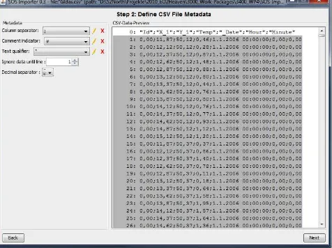
Figure 2-3: Selecting settings for parsing the CSV file
In the next steps the content of the different columns needs to be defined. Depending on the type of da-ta conda-tained in a column further information needs to be set by the user. For example:
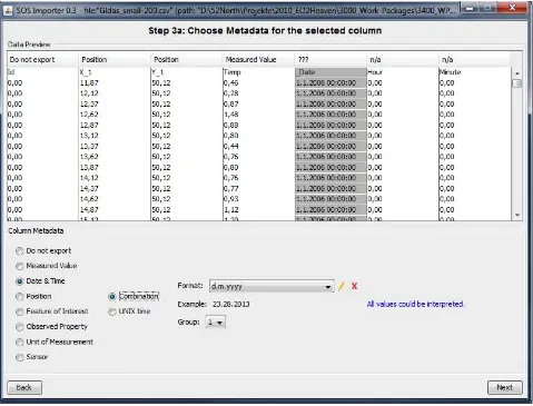
If a column contains data and time, the according format (e.g. dd/MM/yy HH:mm) needs to be described (Figure 2-4)
22
23
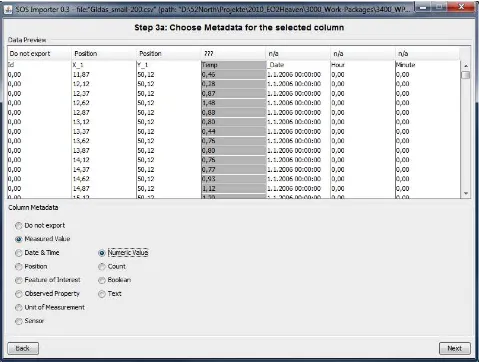
Figure 2-5: Describing the content of the columns (measured value)
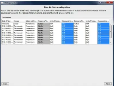
If multiple columns with the same content type are present in a CSV file, according associations must be created, for example
If there are multiple feature of interest columns it must be defined which feature of interest col-umn belongs to which measured value colcol-umn (Figure 2-6)
If there are multiple timestamp columns it must be defined which time stamp column belongs to which measured value column
24
Figure 2-6: Creating associations between measured values and features of interest
25
Figure 2-7: Adding missing metadata (missing time zone)
In case certain metadata elements are missing within the positions of sensor observations, the next step (Figure 2-8) can be used for inserting the according information (e.g. height, EPSG code of the reference system).
Figure 2-8: Adding missing position information (EPSG code and height)
In some cases, certain metadata elements (e.g. names of measurement stations, units of measure-ment, names of sensors, positions) may be missing completely. However, as they are required by the SWE standards, the import tool provides a means for manually adding or even automatically generating such metadata elements.
26
Figure 2-9: Automatically generating feature of interest identifiers
27
Figure 2-10: Manually adding information about the unit of measurement
28
Figure 2-11: Creating sensor identifiers
29
30
Figure 2-13: Setting the positions of the features of interest through text fields
31
Figure 2-14: Setting the URL of a Sensor Observation Service
32
Figure 2-15: Import finished
2.3.4 Summary and Conclusion
The presented tool is a significant step forward to facilitate the practical application of the SOS. By of-fering an easy-to-use approach for publishing sensor data through a SOS, the acceptance of the SOS can be significantly increased. Furthermore it is a valuable tool for end users to integrate their sensor data into a SWE-compliant system.
The current version demonstrates that the general concept of an import tool for legacy data sets into the SOS is feasible. It may already be used for publishing existing data sets with limited background knowledge about the SWE standards.
However, further work will be necessary, especially covering the following aspects:
Better hiding of underlying SWE concepts: the current version of the import tool still confronts the user with several SWE-specific terms (e.g. feature of interest); instead the next version should be further optimized for avoiding the use of SWE-specific terms and replace them by more natural language explanations
33
3
References
EO2HEAVEN, 2011a. D4.7 Specification of the Spatial Information Infrastructure (SII) Implementation Architecture (second issue). Fraunhofer IOSB (Ed.), Deliverable D4.7 of the EO2HEAVEN pro-ject
http://www.eo2heaven.org/sites/default/files/D4.7%20Specification%20of%20the%20SII%20Im plementation%20Architecture.pdf
EO2HEAVEN, 2011b. Specification of Advanced SWE Concepts (second issue). 52°North (Ed.), Deliv-erable D4.8 of the EO2HEAVEN project
http://www.eo2heaven.org/sites/default/files/D4.8_Specification_of_the_Advanced_SWE_Conc epts_Issue_2.pdf
ISO/IEC 10746-1:1998: Information technology – Open Distributed Processing – Reference model. ISO 19156:2011 - Geographic information – Observations and measurements
OGC, 2006. OpenGIS Web Map Server Implementation Specification. Version 1.3.0. OpenGIS Imple-mentation Specification (Status: final), OGC 06-042.
OGC, 2007a. Sensor Observation Service 1.0. OGC 06-009r6
http://portal.opengeospatial.org/files/?artifact_id=26667
OGC, 2007b. Sensor Model Language (SensorML) Implementation Specification. OGC 07-000.
http://portal.opengeospatial.org/files/?artifact_id=21273
OGC, 2007c. Reference Model of the ORCHESTRA Architecture. Version 2.1. OGC Best Practices Document 07-097.
OGC, 2008a. Web Coverage Service (WCS) Implementation Standard. OGC 07-067r5.
http://portal.opengeospatial.org/files/?artifact_id=27297
OGC, 2008b. Robin, A. (2009). OGC SWE Common Data Model Encoding Standard. Version 2.0.0. OGC Encoding Standard 08-094r1.
OGC, 2008c. OGC Sensor Web Enablement (SWE) Architecture. OGC Best Practices Document 06-021r4
http://portal.opengeospatial.org/files/?artifact_id=29405
OGC, 2009a, OGC Policy Standard - The Specification Model - A Standard for Modular specifications. OGC 08-131r3.
https://portal.opengeospatial.org/files/?artifact_id=34762
OGC, 2009c. OGC Sensor Planning Service Implementation Standard. Version 2.0. OpenGIS Imple-mentation Standard. OGC 09-000
OGC, 2009d. Specification of the Sensor Service Architecture, Version 3.0 (Rev. 3.1). OGC Discussion Paper 09-132r1. Deliverable D2.3.4 of the European Integrated Project SANY, FP6-IST-033564, 2009.
http://portal.opengeospatial.org/files/?artifact_id=35888
OGC, 2011a. OGC Implementation Specification: Observations and Measurements (O&M) - XML
Im-plementation 2.0. OGC Document OGC 10-025r1.
http://portal.opengeospatial.org/files/?artifact_id=41510
OGC, 2011b, Lightweight SOS Profile for Stationary In-Situ Sensors. OGC Discussion Paper 11-169r1.
34
OGC, 2012a. Sensor Observation Service 2.0. OGC 12-006.
https://portal.opengeospatial.org/files/?artifact_id=47599
OGC, 2012b: OGC Sensor Model Language. Version 2.0 Implementation Specification (draft). OGC 12-000.
Shafranovich, Y., 2005. Common Format and MIME Type for Comma-Separated Values (CSV) Files. The Internet Society.
35
4
Abbreviations and acronyms
CSV Comma Separated Values
EO Earth Observation
EO2HEAVEN Earth Observation and ENVironmental modelling for the mitigation of HEAlth risks EPSG European Petroleum Survey Group
FOI Feature of Interest
FP6/7 6th/7th Framework Programme
GEOSS Global Earth Observation System of Systems
GML Geography Markup Language
INSPIRE Infrastructure for Spatial Information in the European Community
IS International Standard
ISO International Standardization Organisation IST Information Society Technology
KVP key-value-pair binding OGC Open Geospatial Consortium
ORCHESTRA Open Architecture and Spatial Data Infrastructure for Risk Management O&M Observations and Measurement
REST Representational State Transfer
RM-OA Reference Model of the ORCHESTRA Architecture RM-ODP Reference Model for Open Distributed Processing SANY Sensors Anywhere (FP6 project)
SDI Spatial Data Infrastructure SensorML Sensor Model Language SensorSA Sensor Service Architecture SII Spatial Information Infrastructure SOS Sensor Observation Service SPS Sensor Planning Service SQL Structured Query Language
SWE Sensor Web Enablement
TML Transducer Markup Language
UncertWeb Uncertainty Enabled Model Web URL Uniform Resource Locator
WCS Web Coverage Service
WFS Web Feature Service
WMS Web Map Service