Open Geospatial Consortium
Publication Date: 2014-02-25Approval Date: 2013-06-22
Submission Date: 2013-02-27
Reference URL for this document: http://www.opengis.net/doc/BP/sos-profile-in-situ/1.0
Version: 1.0
Reference number of this document: 11-169r1
Category: Best Practice
Editor(s): Simon Jirka, Christoph Stasch, Arne Bröring
OGC
®Best Practice for Sensor Web Enablement
Lightweight SOS Profile for Stationary In-Situ Sensors
Copyright © 2014 OpenGeospatial Consortium
To obtain additional rights of use, visit http://www.opengeospatial.org/legal/.
Warning
This document defines an OGC Best Practices on a particular technology or approach related to an OGC standard. This document is not an OGC Standard and may not be referred to as an OGC Standard. It is subject to change without notice. However, this document is an official position of the OGC membership on this particular technology topic.
Document type: OGC® Best Practice Document subtype:
ii Copyright © 2014 Open Geospatial Consortium License Agreement
Permission is hereby granted by the Open Geospatial Consortium, ("Licensor"), free of charge and subject to the terms set forth below, to any person obtaining a copy of this Intellectual Property and any associated documentation, to deal in the Intellectual Property without restriction (except as set forth below), including without limitation the rights to implement, use, copy, modify, merge, publish, distribute, and/or sublicense copies of the Intellectual Property, and to permit persons to whom the Intellectual Property is furnished to do so, provided that all copyright notices on the intellectual property are retained intact and that each person to whom the Intellectual Property is furnished agrees to the terms of this Agreement.
If you modify the Intellectual Property, all copies of the modified Intellectual Property must include, in addition to the above copyright notice, a notice that the Intellectual Property includes modifications that have not been approved or adopted by LICENSOR.
THIS LICENSE IS A COPYRIGHT LICENSE ONLY, AND DOES NOT CONVEY ANY RIGHTS UNDER ANY PATENTS THAT MAY BE IN FORCE ANYWHERE IN THE WORLD.
THE INTELLECTUAL PROPERTY IS PROVIDED "AS IS", WITHOUT WARRANTY OF ANY KIND, EXPRESS OR IMPLIED, INCLUDING BUT NOT LIMITED TO THE WARRANTIES OF MERCHANTABILITY, FITNESS FOR A PARTICULAR PURPOSE, AND NONINFRINGEMENT OF THIRD PARTY RIGHTS. THE COPYRIGHT HOLDER OR HOLDERS INCLUDED IN THIS NOTICE DO NOT WARRANT THAT THE FUNCTIONS CONTAINED IN THE INTELLECTUAL PROPERTY WILL MEET YOUR REQUIREMENTS OR THAT THE OPERATION OF THE INTELLECTUAL PROPERTY WILL BE
UNINTERRUPTED OR ERROR FREE. ANY USE OF THE INTELLECTUAL PROPERTY SHALL BE MADE ENTIRELY AT THE USER’S OWN RISK. IN NO EVENT SHALL THE COPYRIGHT HOLDER OR ANY CONTRIBUTOR OF
INTELLECTUAL PROPERTY RIGHTS TO THE INTELLECTUAL PROPERTY BE LIABLE FOR ANY CLAIM, OR ANY DIRECT, SPECIAL, INDIRECT OR CONSEQUENTIAL DAMAGES, OR ANY DAMAGES WHATSOEVER RESULTING FROM ANY ALLEGED INFRINGEMENT OR ANY LOSS OF USE, DATA OR PROFITS, WHETHER IN AN ACTION OF CONTRACT, NEGLIGENCE OR UNDER ANY OTHER LEGAL THEORY, ARISING OUT OF OR IN CONNECTION WITH THE IMPLEMENTATION, USE, COMMERCIALIZATION OR PERFORMANCE OF THIS INTELLECTUAL PROPERTY.
This license is effective until terminated. You may terminate it at any time by destroying the Intellectual Property together with all copies in any form. The license will also terminate if you fail to comply with any term or condition of this Agreement. Except as provided in the following sentence, no such termination of this license shall require the termination of any third party end-user sublicense to the Intellectual Property which is in force as of the date of notice of such termination. In addition, should the Intellectual Property, or the operation of the Intellectual Property, infringe, or in LICENSOR’s sole opinion be likely to infringe, any patent, copyright, trademark or other right of a third party, you agree that LICENSOR, in its sole discretion, may terminate this license without any compensation or liability to you, your licensees or any other party. You agree upon termination of any kind to destroy or cause to be destroyed the Intellectual Property together with all copies in any form, whether held by you or by any third party.
Except as contained in this notice, the name of LICENSOR or of any other holder of a copyright in all or part of the Intellectual Property shall not be used in advertising or otherwise to promote the sale, use or other dealings in this Intellectual Property without prior written authorization of LICENSOR or such copyright holder. LICENSOR is and shall at all times be the sole entity that may authorize you or any third party to use certification marks, trademarks or other special designations to indicate compliance with any LICENSOR standards or specifications.
This Agreement is governed by the laws of the Commonwealth of Massachusetts. The application to this Agreement of the United Nations Convention on Contracts for the International Sale of Goods is hereby expressly excluded. In the event any provision of this Agreement shall be deemed unenforceable, void or invalid, such provision shall be modified so as to make it valid and enforceable, and as so modified the entire Agreement shall remain in full force and effect. No decision, action or inaction by LICENSOR shall be construed to be a waiver of any rights or remedies available to it.
11-169r1
Copyright © 2014 Open Geospatial Consortium iii
Contents
Page1 Scope ... 1
2 Normative references ... 2
3 Terms and definitions ... 3
4 Conventions ... 4
4.1 Abbreviated terms ... 4
5 Overview ... 5
6 Observations and Measurements ... 7
6.1 Introduction ... 7
6.2 Common Observation Properties ... 7
6.3 Observation Types ... 8
7 Sensor Model Language ... 10
7.1 Introduction ... 10
7.2 Profile-specific Schema of a Sensor System ... 10
8 Sensor Observation Service ... 12
8.1 Introduction ... 12
8.2 SOS Operations ... 12
8.2.1 GetCapabilities ... 12
8.2.2 DescribeSensor ... 12
8.2.3 GetObservation ... 12
8.2.4 GetFeatureOfInterest ... 13
9 Bibliography ... 15
10 Examples: Observations & Measurements ... 16
10.1 Measurement ... 16
10.2 CountObservation ... 17
10.3 TruthObservation ... 18
10.4 CategoryObservation ... 19
10.5 TextObservation ... 20
10.6 om:ComplexObservation with swe:DataArray ... 21
11 Examples: Sensor Model Language ... 23
12 Examples: Sensor Observation Service ... 26
12.1 GetCapabilities ... 26
12.1.1 Request ... 26
12.1.2 Response ... 27
iv Copyright © 2014 Open Geospatial Consortium
12.2.2 Response ... 31
12.3 GetObservation ... 32
12.3.1 Request ... 32
12.3.2 Response ... 33
12.4 GetFeatureOfInterest ... 34
12.4.1 Request ... 34
11-169r1
Copyright © 2014 Open Geospatial Consortium v
Figures
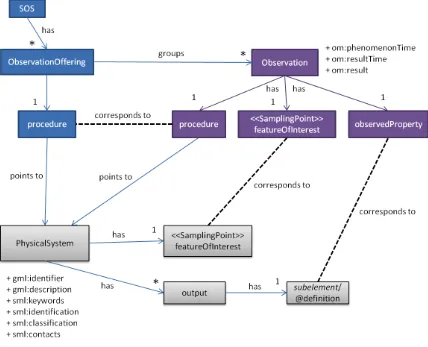
PageFigure 1: Overview of the key information elements and their relationships (informal
vi Copyright © 2014 Open Geospatial Consortium
Tables
Page11-169r1
Copyright © 2014 Open Geospatial Consortium vii
i.
Preface
Suggested additions, changes, and comments on this draft report are welcome and encouraged. Such suggestions may be submitted by email message or by making suggested changes in an edited copy of this document.
If you choose to submit suggested changes by editing this document, please first accept all the current changes, and then make your suggested changes with change tracking on.
ii.
Document terms and definitions
This document uses the standard terms defined in Subclause 5.3 of [OGC 06-121r3], which is based on the ISO/IEC Directives, Part 2. Rules for the structure and drafting of International Standards. In particular, the word “shall” (not “must”) is the verb form used to indicate a requirement to be strictly followed to conform to this standard.
iii.
Submitting organizations
The following organizations submitted this document to the Open Geospatial Consortium Inc.
a. 52° North Initiative for Geospatial Open Source Software GmbH b. Institute for Geoinformatics (IfGI), University of Münster (WWU)
iv.
Document contributor contact points
All questions regarding this document should be directed to the editor or the contributors:
Name Organization
Arne Bröring 52°North GmbH
Simon Jirka 52° North GmbH
viii Copyright © 2014 Open Geospatial Consortium
v.
Revision history
Date Release Editor Primary clauses modified
Description
2011-11-09 0.1.0 Simon Jirka All First version of the Discussion Paper
2013-02-27 0.2.0 Simon Jirka Section 6 Addition of SWE Common observation types
vi.
Changes to the OGC Abstract Specification
The OGC® Abstract Specification does not require changes to accommodate the technical contents of this document.
vii.
Future work
This profile is intended to provide a starting point for a discussion on a minimum set of elements that are necessary when applying the SOS in practice. Thus, it will be necessary to incorporate the results of the discussion paper into later versions of this document. This version of the Discussion Paper includes also complex observations containing swe:DataArrays. In order to ensure a harmonised and consistent use, it will be necessary to include more restrictions and guidance on this observation type in the next version of this Discussion Paper.
In addition, this Discussion Paper may serve as the basis for defining domain specific SOS profiles.
viii.
Acknowledgements
11-169r1
Copyright © 2014 Open Geospatial Consortium ix
Foreword
This document presents a lightweight profile for the SOS 2.0 standard. This profile is specifically designed for the provision of observations gathered by stationary in-situ sensors.
Attention is drawn to the possibility that some of the elements of this document may be the subject of patent rights. The Open Geospatial Consortium shall not be held
responsible for identifying any or all such patent rights.
x Copyright © 2014 Open Geospatial Consortium
Introduction
The OGC Sensor Web Enablement architecture (SWE) addresses the integration of sensors and sensor data into Spatial Data Infrastructures (SDI). Within the SWE architecture the Sensor Observation Service (SOS) plays a central role as it defines an interface for accessing sensor data and metadata. This document describes a lightweight profile of the SOS and the data formats used by the SOS: Observations & Measurements (O&M) for encoding measurement data and the Sensor Model Language (SensorML) for encoding metadata. Other SWE standards which provide more specialized functionality are not part of this minimum lightweight SWE profile.
This profile has been designed in a way that is on the one hand efficient and easy to implement and on the other hand standard compliant. Especially the following aspects were considered during the creation of the profile:
Reducing the number of operations: certain operations of the SOS standard were designed for very specific needs; these operations were left out of this profile Reducing the complexity of the SOS operations (e.g. less complex filters for
requesting sensor data)
Focus on fixed in-situ sensors as these sensors are the type of sensors that are used in the broad majority of SWE use cases in practice (for widening this focus in future, extensions may be developed)
OGC® Best Practice 11-169r1
Copyright © 2014 Open Geospatial Consortium 1
Lightweight SOS Profile for Stationary In-Situ Sensors Best
Practice
1 Scope
This Best Practice document describes a lightweight SOS 2.0 profile for stationary in-situ sensors. Besides the SOS itself this document also addresses the data formats used by the SOS: Observations & Measurements 2.0 (O&M) for encoding measurement data and the Sensor Model Language 2.0 (SensorML) for encoding metadata. Other SWE standards which provide more specialized functionality are not part of this minimum lightweight SWE profile.
2 Copyright © 2014 Open Geospatial Consortium
2 Normative references
The following normative documents contain provisions that, through reference in this text, constitute provisions of this document. For dated references, subsequent amendments to, or revisions of, any of these publications do not apply. For undated references, the latest edition of the normative document referred to applies.
OGC 06-121r3, OpenGIS® Web Services Common Specification
OGC 07-036, OpenGIS® Geography Markup Language (GML) Encoding Standard OGC 08-094r1, OGC® SWE Common Data Model Encoding Standard 2.0.0
OGC 09-001, OpenGIS® SWE Service Model Implementation Standard 2.0 OGC 10-025r1, Observations and Measurements - XML Implementation 2.0
OGC 12-000, OGC® SensorML: Model and XML Encoding Candidate Standard 2.0 OGC 12-006, OGC® Sensor Observation Service 2.0 Interface Standard
11-169r1
Copyright © 2014 Open Geospatial Consortium 3
3 Terms and definitions
For the purposes of this specification, the definitions specified in Clause 4 of the OWS Common Implementation Specification [OGC 06-121r3] shall apply. In addition, the terms and definitions as described in the following documents apply:
OGC 07-036, OpenGIS® Geography Markup Language (GML) Encoding Standard
OGC 08-094r1, OGC® SWE Common Data Model Encoding Standard 2.0.0 OGC 09-001, OpenGIS® SWE Service Model Implementation Standard 2.0 OGC 10-025r1, Observations and Measurements - XML Implementation 2.0 OGC 12-000, OGC® SensorML: Model and XML Encoding Candidate Standard
2.0
4 Copyright © 2014 Open Geospatial Consortium
4 Conventions
4.1 Abbreviated terms
Most of the abbreviated terms listed in Subclause 5.1 of the OWS Common Implementation Specification [OGC 06-121r3] apply to this document, plus the following abbreviated terms.
Some more frequently used abbreviated terms: O&M Observations and Measurements SensorML Sensor Model Language
11-169r1
Copyright © 2014 Open Geospatial Consortium 5
5 Overview
The next sections describe a lightweight profile for the SOS and its accompanying data encodings SensorML and O&M. At the end of this document an annex is provided that contains examples of the operations and encodings that are part of this profile.
This profile is optimized for scenarios where an SOS is utilized to provide interoperable access to data measured within a network of stationary in-situ sensor stations, each of which may have a number of sensors attached. Examples for such sensors are weather stations or air quality stations. Central in such scenarios are the concepts of sensor, sensor station (= sensor system). The sensor (e.g. a thermometer or anemometer) is attached to the stationary sensor system (e.g. a weather station).
To give an overview, the figure below (Figure 1) displays in an informal way the key elements of the three utilized standards that are used to represent the measured data as well as relevant metadata (SOS, O&M, and SensorML). The figure points out how those elements are interrelated. The elements from the SOS specification are coloured in blue, the O&M elements are displayed in violet and SensorML elements are shown in grey. As shown in the figure, the SOS and O&M specifications abstract from the term sensor and instead consider the procedure concept. In case of this profile, the procedure is always a stationary sensor system, which is modelled in SensorML using the PhysicalSystem type. Sensors attached to the sensor system may be modelled as PhysicalComponents and associated with the PhysicalSystem, however, this profile does not demand the linkage to those subcomponents.
11-169r1
Copyright © 2014 Open Geospatial Consortium 7
6 Observations and Measurements
6.1 Introduction
The Observations & Measurements standard offers an encoding for data observed by sensors. It is the standard format the SOS is providing its data. However, as O&M has been designed to be extremely versatile and comprehensive it has also a certain complexity. Thus, this lightweight profile has been defined containing only those elements of O&M which are essential for most common use cases. Within this document we include the following observation types which differ by the result models used:
om:Measurement om:CountObservation om:TruthObservation om:CategoryObservation om:TextObservation
om:ComplexObservation with swe:DataArray
6.2 Common Observation Properties
In order to reduce the complexity of O&M Observations, only a limited set of O&M elements shall be used. These are1:
gml:identifier (mandatory): this element can be used for uniquely identifying or referring to a specific observation.
om:phenomenonTime (mandatory): this element describes the time instant or time period for which the observation contains sensor data; within the lightweight profile this is restricted to the data types TimeInstant and TimePeriod (other kinds of time (result and valid time) are currently not considered for this profile).
om:resultTime (mandatory): this element provides the time when the result became available; often this is identical to the phenomenonTime.
om:procedure (mandatory): the identifier of the sensor instance that has generated the observation.
8 Copyright © 2014 Open Geospatial Consortium
observed.
om:featureOfInterest (mandatory): an identifier of the geometric feature (e.g. sensor station) to which the observation is associated; within the lightweight profile this is limited to sampling points.
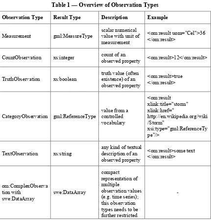
om:result (mandatory): the observed value; the type of the result is restricted to the types shown in Table 1.
6.3 Observation Types
The different subtypes and its result types are shown in Table 1.
Table 1 — Overview of Observation Types
Observation Type Result Type Description Example
Measurement gml:MeasureType
CountObservation xs:integer count of an
11-169r1
Copyright © 2014 Open Geospatial Consortium 9
10 Copyright © 2014 Open Geospatial Consortium
7 Sensor Model Language
7.1 Introduction
The Sensor Model Language (SensorML) is used within the SOS for encoding sensor metadata documents that are returned in case of DescribeSensor requests. This lightweight profile defines a minimum set of mandatory metadata that need to be provided in a SensorML document. Complex elements of SensorML that are intended for very specific applications are not considered within this lightweight profile but may be added if necessary.
7.2 Profile-specific Schema of a Sensor System
Every sensor system shall be modeled as a PhysicalSystem. The following metadata items are mandatory for a PhysicalSystem which conforms to this profile:
gml:description (mandatory):
Short textual description of the sensor or sensor system.
gml:identifier (mandatory):
Unique identifier of the sensor system.
sml:keywords (mandatory):
Terms which help to describe the sensor system and serve for discovery purposes. For example, the phenomena observed by the system or the types of contained sensors can be mentioned.
sml:identification (mandatory):
This element contains identifiers of the sensor system.
Each "identifier/Term" element contained in the "IdentifierList" must have a "definition" attribute which links to the semantics of the sensor system.
One identifier has to be present which contains the definition "urn:ogc:def:identifier:OGC:shortname". The value of its contained "Term" element represents a human understandable name for the instance.
One identifier has to be present which contains the definition "urn:ogc:def:identifier:OGC:longname". The value of its contained "Term" element represents a human understandable name for the sensor system.
sml:classification (mandatory):
11-169r1
Copyright © 2014 Open Geospatial Consortium 11
Each "classifier/Term" element contained in the "ClassifierList" must have a "definition" attribute. This attribute links to the semantics of the identifier.
One classifier has to be present which contains the definition “http://www.opengis.net/def/property/OGC/0/SensorType”. The value of its contained “Term” element states the type of the sensor system (e.g., “weather station”).
sml:contacts (mandatory):
This element contains contact information about the operator of the sensor.
The element "contacts/ContactList/member/gmd:CI_ResponsibleParty" has to be present to define the responsible party of the sensor system.
sml:featuresOfInterest (mandatory):
This element contains the real world entity, the feature of interest, which is observed by the sensor system. In case of this profile, the feature of interest is a station and modelled as a SamplingPoint.
sml:outputs (mandatory):
The outputs of the sensors attached to the sensor system.
Each child-element of an "output" has to use the "definition"-attribute to specify the URI of the observed property. If the child-element of the output is a "swe:Quantity" it has to contain the "swe:uom" element which specifies the "code" attribute stating the UCUM code.
Depending on the observation types the outputs have to be described as one of the following elements
o swe:Quantity (in case of Measurement)
o swe:Count (in case of CountObservation)
o swe:Boolean (in case of TruthObservation)
o swe:Category (in case of CategoryObservation)
12 Copyright © 2014 Open Geospatial Consortium
8 Sensor Observation Service
8.1 Introduction
This lightweight SOS profile comprises those operations which are mandatory within the SOS standard (GetCapabilities, DescribeSensor and GetObservation) so that they must be implemented by every standard compliant SOS server. Furthermore the GetFeatureOfInterest operation has been included as a mandatory operation within this profile since it allows accessing the geometries of sensor stations.
8.2 SOS Operations
8.2.1 GetCapabilities
The GetCapabilities operation is common for every OGC web service specification. It is important to support this operation as it provides the metadata necessary for clients to generate valid SOS requests.
The response shall contain the following information:
the supported operations of the SOS instance shall be listed in the ows:OperationsMetadata section, if this section has been requested in the request. the identifiers of all sensor instances encapsulated by the SOS instance shall be
provided in the procedure element of each ObservationOffering for this sensor. the identifiers of all observed phenomena shall be provided in the
observedProperty elements of the Contents or ObservationOfferings
8.2.2 DescribeSensor
The DescribeSensor operation allows retrieving metadata about the sensors encapsulated by a SOS instance. The operation is defined as mandatory in the SOS specification. Thus, it is included in the minimum profile so that servers must offer this operation.
The request of the DescribeSensor operation is very simple as the only parameter required by this profile consists of the identifier of the sensor for which a metadata document is requested. The response is a SensorML document (the lightweight structure for the SensorML response is defined section 7).
8.2.3 GetObservation
11-169r1
Copyright © 2014 Open Geospatial Consortium 13
parameters. In detail, the following parameters are included in this lightweight SOS profile and can be used in a GetObservation service request and therefore shall be supported by every SOS server implementation compliant to this profile (please note: the use of these parameters by clients is optional):
offering: the identifier of the offering that contains the requested sensor data temporalFilter: for specifying the time for which sensor data is requested; the
temporal filter is limited within the lightweight SOS profile to the following types:
o During a time period
o Equal to a time instant
procedure: the identifiers of the sensor or sensor network instances from which data is requested
observedProperty: the identifiers of the phenomena for which data is requested featureOfInterest: Identifier of the geometric objects for which sensor data is
requested
spatialFilter: is restricted within the lightweight SOS profile to the Bounding box of an area for which data is requested
8.2.4 GetFeatureOfInterest
The GetFeatureOfInterest operation allows retrieving the spatial features that are attached to observations. In case of fixed in-situ stations, these features are usually equal to the location of the stations at which measurements were performed. As the access to the geometries of measurements is a requirement for creating map visualizations of the sensors and their data, the GetFeatureOfInterest operation has been included for servers in this lightweight SOS profile. However, not every client might rely on this operation (e.g. clients that only show diagrams of time series data).
In order to reduce the complexity of this operation, its request parameters are restricted within this profile. Clients may request geometries using only one of these three parameters:
featureOfInterest: identifier of a feature of interest which shall be returned
spatialFilter: restricted within the lightweight SOS profile to the Bounding box of an area for which features are requested
14 Copyright © 2014 Open Geospatial Consortium
11-169r1
Copyright © 2014 Open Geospatial Consortium 15
9 Bibliography
[1] Jirka, Simon and Christoph Stasch (2011). A Lightweight Sensor Web
Enablement Profile for Stationary In-Situ Sensors. INSPIRE Conference 2011, Edinburgh, United Kingdom.
[2] Bröring, Arne, Johannes Echterhoff, Simon Jirka, Ingo Simonis, Thomas Everding, Christoph Stasch, Steve Liang and Rob Lemmens (2011). "New Generation Sensor Web Enablement." MDPI Sensors 11(3): 2652-2699.
[3] Houbie, Frédéric, Fabian Skivée and Simon Jirka (2010). OGC Discussion Paper: OGC Catalogue Services Specification 2.0 Extension Package for ebRIM
Application Profile: SensorML 0.3.0 (09-163r2). Wayland, MA, USA, Open Geospatial Consortium Inc.
[4] Jirka, Simon, Arne Bröring and Christoph Stasch (2009). "Discovery Mechanisms for the Sensor Web." MDPI Sensors 9(4): 2661-2681.
16 Copyright © 2014 Open Geospatial Consortium
10 Examples: Observations & Measurements
10.1 Measurement
<?xml version="1.0" encoding="UTF-8"?>
<!--============================================================= This observation depicts an example
-point as sampling location -time instant as phenomenon time
-result is a measure value (double with units of measure information)
==============================================================-->
<om:OM_Measurement gml:id="obsTest1" xmlns:om="http://www.opengis.net/om/2.0" xmlns:xsi="http://www.w3.org/2001/XMLSchema-instance"
xmlns:sams="http://www.opengis.net/samplingSpatial/2.0" xmlns:sf="http://www.opengis.net/sampling/2.0"
xmlns:xlink="http://www.w3.org/1999/xlink" xmlns:gml="http://www.opengis.net/gml/3.2"
xsi:schemaLocation="http://www.opengis.net/om/2.0 ../observation.xsd">
<!--============================================================= global identifier of the observation
==============================================================-->
<gml:identifier codeSpace="http://www.myWebSite.org">obsTest1</gml:identifier>
<!--=============================================================
phenomenon time represents the time when the observation was taken (so when the sensor has interacted with reality
==============================================================-->
<om:phenomenonTime>
<gml:TimeInstant gml:id="ot1t">
<gml:timePosition>2005-01-11T16:22:25.00</gml:timePosition>
</gml:TimeInstant>
</om:phenomenonTime>
<!--=============================================================
result time represents the time when the result value was produced; might differ for example in case of a soil sample; sample has been taken during phenomenonTime and then evaluate later in a laboratory during resultTime
==============================================================-->
<om:resultTime xlink:href="#ot1t"/>
<!--============================================================= procedure has produced the observation's result (usually a sensor)
==============================================================-->
<om:procedure xlink:href="http://www.example.org/register/process/scales34.xml"/>
<!--=============================================================
observedProperty usually contains a link to a vocabulary containing the definition of the property which has been observed; in case of environmental modelling this is usually a physical phenomenon (e.g. temperature, air pollutant concentration, etc.)
==============================================================-->
<om:observedProperty xlink:href="urn:ogc:def:phenomenon:OGC:temperature"/>
<!--============================================================= feature of interest carries the sampling geometry of the observation
==============================================================-->
<om:featureOfInterest>
<sams:SF_SpatialSamplingFeature gml:id="SamplingPoint1">
<sf:type xlink:href="http://www.opengis.net/def/samplingFeatureType/OGC- OM/2.0/SF_SamplingPoint"/>
</sams:SF_SpatialSamplingFeature>
</om:featureOfInterest>
<!--=============================================================
observation result is an numerical value with information about the unit of measurements
11-169r1
Copyright © 2014 Open Geospatial Consortium 17
<om:result uom="Cel">36</om:result> </om:OM_Measurement>
10.2 CountObservation
<?xml version="1.0" encoding="UTF-8"?>
<!--============================================================= This observation depicts an example with
-point as sampling location -timeInstant as phenomenon time -result is a count value
==============================================================-->
<om:OM_CountObservation gml:id="obsTest1" xmlns:om="http://www.opengis.net/om/2.0" xmlns:xsi="http://www.w3.org/2001/XMLSchema-instance"
xmlns:sams="http://www.opengis.net/samplingSpatial/2.0" xmlns:sf="http://www.opengis.net/sampling/2.0"
xmlns:xlink="http://www.w3.org/1999/xlink" xmlns:gml="http://www.opengis.net/gml/3.2"
xsi:schemaLocation="http://www.opengis.net/om/2.0 ../observation.xsd">
<!--============================================================= global identifier of the observation
==============================================================-->
<gml:identifier codeSpace="http://www.uncertweb.org">obsTest1</gml:identifier>
<!--=============================================================
phenomenon time represents the time when the observation was taken (so when the sensor has interacted with reality
==============================================================-->
<om:phenomenonTime>
<gml:TimeInstant gml:id="ot1t">
<gml:timePosition>2005-01-11T16:22:25.00</gml:timePosition>
</gml:TimeInstant>
</om:phenomenonTime>
<!--=============================================================
result time represents the time when the result value was produced; might differ for example in case of a soil sample; sample has been taken during phenomenonTime and then evaluate later in a laboratory during resultTime
==============================================================-->
<om:resultTime xlink:href="#ot1t"/>
<!--============================================================= procedure has produced the observation's result (usually a sensor)
==============================================================-->
<om:procedure xlink:href="http://www.example.org/register/process/counter.xml"/>
<!--=============================================================
observedProperty usually contains a link to a vocabulary containing the definition of the property which has been observed; in case of environmental modelling this is usually a physical phenomenon (e.g. temperature, air pollutant concentration, etc.)
==============================================================-->
<om:observedProperty xlink:href="urn:ogc:def:phenomenon:OGC:numberOfPersons"/>
<!--============================================================= feature of interest carries the sampling geometry of the observation
==============================================================-->
<om:featureOfInterest>
<sams:SF_SpatialSamplingFeature gml:id="SamplingPoint1">
<sf:type xlink:href="http://www.opengis.net/def/samplingFeatureType/OGC- OM/2.0/SF_SamplingPoint"/>
</sams:SF_SpatialSamplingFeature>
</om:featureOfInterest>
<!--============================================================= observation result is a count value
==============================================================-->
18 Copyright © 2014 Open Geospatial Consortium <?xml version="1.0" encoding="UTF-8"?>
<!--============================================================= This observation depicts an example with
-point as sampling location -timeInstant as phenomenonTime
-result is a reference to a coverage on a server
==============================================================-->
<om:OM_TruthObservation gml:id="obsTest1" xmlns:om="http://www.opengis.net/om/2.0" xmlns:xsi="http://www.w3.org/2001/XMLSchema-instance"
xmlns:sams="http://www.opengis.net/samplingSpatial/2.0" xmlns:sf="http://www.opengis.net/sampling/2.0"
xmlns:gmd="http://www.isotc211.org/2005/gmd"
xmlns:xlink="http://www.w3.org/1999/xlink" xmlns:gml="http://www.opengis.net/gml/3.2" xsi:schemaLocation="http://www.opengis.net/om/2.0 ../observation.xsd">
<!--============================================================= global identifier of the observation
==============================================================-->
<gml:identifier codeSpace="http://www.uncertweb.org">obsTest1</gml:identifier>
<!--=============================================================
phenomenon time represents the time when the observation was taken (so when the sensor has interacted with reality
==============================================================-->
<om:phenomenonTime>
<gml:TimeInstant gml:id="ot1t">
<gml:timePosition>2005-01-11T16:22:25.00</gml:timePosition>
</gml:TimeInstant>
</om:phenomenonTime>
<!--=============================================================
result time represents the time when the result value was produced; might differ for example in case of a soil sample; sample has been taken during phenomenonTime and then evaluate later in a laboratory during resultTime
==============================================================-->
<om:resultTime xlink:href="#ot1t"/>
<!--============================================================= procedure has produced the observation's result (usually a sensor)
==============================================================-->
<om:procedure xlink:href="http://www.example.org/register/process/scales34.xml"/>
<!--=============================================================
observedProperty usually contains a link to a vocabulary containing the definition of the property which has been observed; in case of environmental modelling this is usually a physical phenomenon (e.g. temperature, air pollutant concentration, etc.)
==============================================================-->
<om:observedProperty xlink:href="urn:ogc:def:phenomenon:OGC:temperature"/>
<!--============================================================= feature of interest carries the sampling geometry of the observation
==============================================================-->
<om:featureOfInterest>
<sams:SF_SpatialSamplingFeature gml:id="SamplingPoint1">
<sf:type xlink:href="http://www.opengis.net/def/samplingFeatureType/OGC- OM/2.0/SF_SamplingPoint"/>
</sams:SF_SpatialSamplingFeature>
</om:featureOfInterest>
<!--============================================================= observation result is a boolean (truth) value
==============================================================-->
11-169r1
Copyright © 2014 Open Geospatial Consortium 19
10.4 CategoryObservation
<?xml version="1.0" encoding="UTF-8"?>
<!--============================================================= This observation depicts an example with
-point as sampling location -time period as phenomenon time
-result is a categorical value (category with link to code space)
==============================================================-->
<om:OM_CategoryObservation gml:id="obsTest1" xmlns:om="http://www.opengis.net/om/2.0" xmlns:xsi="http://www.w3.org/2001/XMLSchema-instance"
xmlns:sams="http://www.opengis.net/samplingSpatial/2.0" xmlns:sf="http://www.opengis.net/sampling/2.0" xmlns:xlink="http://www.w3.org/1999/xlink"
xmlns:gml="http://www.opengis.net/gml/3.2"
xsi:schemaLocation="http://www.opengis.net/om/2.0 ../observation.xsd">
<!--============================================================= global identifier of the observation
==============================================================-->
<gml:identifier codeSpace="http://www.myWebSite.org">obsTest1</gml:identifier>
<!--=============================================================
phenomenon time represents the time when the observation was taken (so when the sensor has interacted with reality
==============================================================-->
<om:phenomenonTime>
<gml:TimeInstant gml:id="ot1t">
<gml:timePosition>2005-01-11T16:22:25.00</gml:timePosition>
</gml:TimeInstant>
</om:phenomenonTime>
<!--=============================================================
result time represents the time when the result value was produced; might differ for example in case of a soil sample; sample has been taken during phenomenonTime and then evaluate later in a laboratory during resultTime
==============================================================-->
<om:resultTime xlink:href="#ot1t"/>
<!--============================================================= procedure has produced the observation's result (usually a sensor)
==============================================================-->
<om:procedure xlink:href="http://www.example.org/register/process/scales34.xml"/>
<!--=============================================================
observedProperty usually contains a link to a vocabulary containing the definition of the property which has been observed; in case of environmental modelling this is usually a physical phenomenon (e.g. temperature, air pollutant concentration, etc.)
==============================================================-->
<om:observedProperty xlink:href="urn:ogc:def:phenomenon:OGC:temperature"/>
<!--============================================================= feature of interest carries the sampling geometry of the observation
==============================================================-->
<om:featureOfInterest>
<sams:SF_SpatialSamplingFeature gml:id="SamplingPoint1">
<sf:type xlink:href="http://www.opengis.net/def/samplingFeatureType/OGC- OM/2.0/SF_SamplingPoint"/>
</sams:SF_SpatialSamplingFeature>
</om:featureOfInterest>
<!--============================================================= observation result is an uncertainty value
==============================================================-->
<om:result codeSpace="http://www.uncertweb.org/tempCodeSpace/tempCategories.xml"> warm</om:result>
20 Copyright © 2014 Open Geospatial Consortium <?xml version="1.0" encoding="UTF-8"?>
<!--============================================================= This observation depicts an example with
-point as sampling location -time instant as phenomenon time -result is a free text value
==============================================================-->
<om:OM_TextObservation gml:id="obsTest1" xmlns:om="http://www.opengis.net/om/2.0" xmlns:xsi="http://www.w3.org/2001/XMLSchema-instance"
xmlns:sams="http://www.opengis.net/samplingSpatial/2.0" xmlns:sf="http://www.opengis.net/sampling/2.0"
xmlns:gmd="http://www.isotc211.org/2005/gmd" xmlns:xlink="http://www.w3.org/1999/xlink" xmlns:gml="http://www.opengis.net/gml/3.2"
xsi:schemaLocation="http://www.opengis.net/om/2.0 ../observation.xsd">
<!--============================================================= global identifier of the observation
==============================================================-->
<gml:identifier codeSpace="http://www.myWebSite.org">obsTest1</gml:identifier>
<!--=============================================================
phenomenon time represents the time when the observation was taken (so when the sensor has interacted with reality
==============================================================-->
<om:phenomenonTime>
<gml:TimeInstant gml:id="ot1t">
<gml:timePosition>2005-01-11T16:22:25.00</gml:timePosition>
</gml:TimeInstant>
</om:phenomenonTime>
<!--=============================================================
result time represents the time when the result value was produced; might differ for example in case of a soil sample; sample has been taken during phenomenonTime and then evaluate later in a laboratory during resultTime
==============================================================-->
<om:resultTime xlink:href="#ot_tp_1"/>
<!--============================================================= procedure has produced the observation's result (usually a sensor)
==============================================================-->
<om:procedure xlink:href="http://www.example.org/register/process/scales34.xml"/>
<!--=============================================================
observedProperty usually contains a link to a vocabulary containing the definition of the property which has been observed; in case of environmental modelling this is usually a physical phenomenon (e.g. temperature, air pollutant concentration, etc.)
==============================================================-->
<om:observedProperty xlink:href="urn:ogc:def:phenomenon:OGC:species:flyingHorse"/>
<!--============================================================= feature of interest carries the sampling geometry of the observation
==============================================================-->
<om:featureOfInterest>
<sams:SF_SpatialSamplingFeature gml:id="SamplingPoint1">
<sf:type xlink:href="http://www.opengis.net/def/samplingFeatureType/OGC- OM/2.0/SF_SamplingPoint "/>
</sams:SF_SpatialSamplingFeature>
</om:featureOfInterest>
<!--============================================================= observation result is free text
==============================================================-->
11-169r1
Copyright © 2014 Open Geospatial Consortium 21
10.6 om:ComplexObservation with swe:DataArray
<?xml version="1.0" encoding="UTF-8"?>
<!--============================================================= This observation depicts an example with
-point as sampling location -time period as phenomenon time -result is a swe:DataArrray
==============================================================-->
<om:OM_Observation gml:id="obsTest1" xmlns:om="http://www.opengis.net/om/2.0" xmlns:swe="http://www.opengis.net/swe/2.0"
xmlns:sams="http://www.opengis.net/samplingSpatial/2.0" xmlns:sf="http://www.opengis.net/sampling/2.0"
xmlns:gmd="http://www.isotc211.org/2005/gmd"
xmlns:xsi="http://www.w3.org/2001/XMLSchema-instance" xmlns:xlink="http://www.w3.org/1999/xlink"
xmlns:gml="http://www.opengis.net/gml/3.2"
xsi:schemaLocation="http://www.opengis.net/om/2.0
http://schemas.opengis.net/om/2.0/observation.xsd
http://www.opengis.net/swe/2.0
http://schemas.opengis.net/sweCommon/2.0/swe.xsd">
<!--============================================================= global identifier of the observation
==============================================================-->
<gml:identifier codeSpace="http://www.myWebSite.org">obsTest1</gml:identifier> <!--=============================================================
phenomenon time represents the time when the observation was taken (so when the sensor has interacted with reality
==============================================================-->
<om:phenomenonTime>
<gml:TimeInstant gml:id="ot1t">
<gml:timePosition>2005-01-11T16:22:25.00</gml:timePosition> </gml:TimeInstant>
</om:phenomenonTime>
<!--=============================================================
result time represents the time when the result value was produced; might differ for example in case of a soil sample; sample has been taken during phenomenonTime and then evaluate later in a laboratory during resultTime
==============================================================-->
<om:resultTime xlink:href="#ot_tp_1"/>
<!--=============================================================
procedure has produced the observation's result (usually a sensor)
==============================================================-->
<om:procedure xlink:href="http://www.example.org/register/process/scales34.xml"/> <!--=============================================================
observedProperty usually contains a link to a vocabulary containing the definition of the property which has been observed; in case of environmental modelling this is usually a physical phenomenon (e.g. temperature, air pollutant concentration, etc.)
==============================================================-->
<om:observedProperty xlink:href="urn:ogc:def:phenomenon:OGC:air:temperature"/> <!--=============================================================
feature of interest carries the sampling geometry of the observation
==============================================================-->
<om:featureOfInterest>
<sams:SF_SpatialSamplingFeature gml:id="SamplingPoint1"> <sf:type xlink:href="
http://www.opengis.net/def/samplingFeatureType/OGC-OM/2.0/SF_SamplingPoint "/> <sf:sampledFeature xsi:nil="true"/>
</sams:SF_SpatialSamplingFeature> </om:featureOfInterest>
<!--=============================================================
22 Copyright © 2014 Open Geospatial Consortium
<om:result xsi:type="swe:DataArrayPropertyType"> <swe:DataArray>
<swe:elementCount> <swe:Count>
<swe:value>5</swe:value> </swe:Count>
</swe:elementCount>
<swe:elementType name="point"> <swe:DataRecord>
<swe:field name="height">
<swe:Quantity definition="http://mmisw.org/ont/cf/parameter/height"> <swe:label>Sampling Point Vertical Location</swe:label>
<swe:uom code="m"/> </swe:Quantity>
</swe:field>
<swe:field name="airtemperature">
<swe:Quantity definition="urn:ogc:def:phenomenon:OGC:air:temperature"> <swe:label>Air Temperature</swe:label>
<swe:uom code="Cel"/> </swe:Quantity>
</swe:field> </swe:DataRecord> </swe:elementType> <swe:encoding>
<swe:TextEncoding blockSeparator=";" tokenSeparator=","/> </swe:encoding>
<swe:values>
0,20.9;100,19.7;200,18.2;300,17.5;400,16.5
</swe:values> </swe:DataArray> </om:result>
11-169r1
Copyright © 2014 Open Geospatial Consortium 23
11 Examples: Sensor Model Language
<?xml version="1.0" encoding="UTF-8"?>
<PhysicalSystem gml:id="sensor_id" xmlns="http://www.opengis.net/sensorML/2.0" xmlns:swe="http://www.opengis.net/swe/2.0"
xmlns:gml="http://www.opengis.net/gml/3.2"
xmlns:xsi="http://www.w3.org/2001/XMLSchema-instance" xmlns:xlink="http://www.w3.org/1999/xlink"
xmlns:gmd="http://www.isotc211.org/2005/gmd" xmlns:gco="http://www.isotc211.org/2005/gco"
xmlns:sams="http://www.opengis.net/samplingSpatial/2.0" xmlns:sf="http://www.opengis.net/sampling/2.0"
xsi:schemaLocation=" http://www.opengis.net/sensorML/2.0
http://schemas.opengis.net/sensorML/2.0/sensorML.xsd http://www.opengis.net/samplingSpatial/2.0
http://schemas.opengis.net/samplingSpatial/2.0/spatialSamplingFeature.xsd">
<!--=============================================================
gml:description is used for a short textual description of the sensor or sensor system and the gml:identifier provides a unique identifier of the sensor or sensor system
==============================================================-->
<gml:description>A weather station on top of the 52North building</gml:description>
<gml:identifier codeSpace="not_used">
urn:ogc:object:feature:Sensor:52North:weatherStation123
</gml:identifier>
<!--=============================================================
For discovery purposes, human-readable keywords shall be given. For example, the phenomena observed by the system or the types of contained sensors can be mentioned.
==============================================================-->
Each "identifier/Term" element contained in the "IdentifierList" must have a "definition" attribute. This attribute links to the semantics of the identifier.
One identifier has to contain the definition "urn:ogc:def:identifier:OGC:shortname". The value of its contained "Term" element represents a human understandable name for the instance.
One identifier has to contain the definition "urn:ogc:def:identifier:OGC:longname". The value of its contained "Term" element represents a human understandable name for the instance.
Each "classifier/Term" element contained in the "ClassifierList" must have a "definition" attribute. This attribute links to the semantics of the identifier.
24 Copyright © 2014 Open Geospatial Consortium <ClassifierList>
<classifier>
<Term definition="http://www.opengis.net/def/property/OGC/0/SensorType">
<label>sensorType</label>
The element "contacts/ContactList/member/gmd:CI_ResponsibleParty" has to be present to define the responsible party of the sensor system.
==============================================================--> The geometric sensor to which the system is associated
==============================================================-->
<featuresOfInterest>
<FeatureList>
<member>
11-169r1
Copyright © 2014 Open Geospatial Consortium 25
<gml:identifier codeSpace="">
</featuresOfInterest>
<!--=============================================================
The "OutputList"-element has to list up at least all "output"s of the PhysicalSystem. Each child-element of an "output" has to use the "definition"-attribute to specify the URI of the observed property. If the child-element of the output is a "swe:Quantity" it has to contain the "swe:uom" element which specifies the "code" attribute stating the UCUM code.
definition="http://sweet.jpl.nasa.gov/2.3/phen.owl#Precipitation">
<swe:uom code="mm"/>
</swe:Quantity>
</output>
<output name="windSpeed">
<swe:Quantity
definition="http://sweet.jpl.nasa.gov/2.0/atmoWind.owl#WindSpeed">
<swe:uom code="m/s"/>
</swe:Quantity>
</output>
<output name="temperature">
<swe:Quantity
definition="http://sweet.jpl.nasa.gov/2.3/propTemperature.owl#Temperature">
26 Copyright © 2014 Open Geospatial Consortium
12 Examples: Sensor Observation Service
12.1 GetCapabilities
12.1.1 Request
<?xml version="1.0" encoding="UTF-8"?>
<soap12:Envelope xmlns:soap12="http://www.w3.org/2003/05/soap-envelope"
xsi:schemaLocation="http://www.w3.org/2003/05/soap-envelope
http://www.w3.org/2003/05/soap-envelope/soap-envelope.xsd http://www.opengis.net/sos/2.0
http://schemas.opengis.net/sos/2.0/sos.xsd" xmlns:sos="http://www.opengis.net/sos/2.0" xmlns:wsa="http://www.w3.org/2005/08/addressing" xmlns:xsi="http://www.w3.org/2001/XMLSchema-instance" xmlns:ows="http://www.opengis.net/ows/1.1">
<soap12:Header>
<wsa:To>http://www.ogc.org/SPS</wsa:To>
<wsa:Action>http://www.opengis.net/sps/2.0/GetCapabilities</wsa:Action>
<wsa:ReplyTo>
<wsa:Address>http://my.client.com/client/myReceiver</wsa:Address>
</wsa:ReplyTo>
<wsa:MessageID>http://my.client.com/uid/msg-0010</wsa:MessageID>
</soap12:Header>
<soap12:Body>
<GetCapabilities service="SOS">
<ows:AcceptVersions>
<ows:Version>2.0.0</ows:Version>
</ows:AcceptVersions>
<ows:Sections>
<ows:Section>OperationsMetadata</ows:Section>
<ows:Section>ServiceIdentification</ows:Section>
<ows:Section>ServiceProvider</ows:Section>
<ows:Section>Filter_Capabilities</ows:Section>
<ows:Section>InsertionCapabilities</ows:Section>
<ows:Section>Contents</ows:Section>
</ows:Sections>
</GetCapabilities>
11-169r1
Copyright © 2014 Open Geospatial Consortium 27
12.1.2 Response
<?xml version="1.0" encoding="UTF-8"?>
<soap12:Envelope xmlns:soap12="http://www.w3.org/2003/05/soap-envelope"
xsi:schemaLocation="http://www.w3.org/2003/05/soap-envelope
http://www.w3.org/2003/05/soap-envelope/soap-envelope.xsd http://www.opengis.net/sos/2.0
http://schemas.opengis.net/sos/2.0/sos.xsd"
xmlns:xsi="http://www.w3.org/2001/XMLSchema-instance" xmlns:wsa="http://www.w3.org/2005/08/addressing" xmlns:swe="http://www.opengis.net/swe/2.0" xmlns:swes="http://www.opengis.net/swes/2.0" xmlns:ows="http://www.opengis.net/ows/1.1" xmlns:sos="http://www.opengis.net/sos/2.0" xmlns:fes="http://www.opengis.net/fes/2.0" xmlns:gml="http://www.opengis.net/gml/3.2" xmlns:ogc="http://www.opengis.net/ogc" xmlns:xlink="http://www.w3.org/1999/xlink">
<soap12:Header>
<wsa:To>http://my.client.com/client/myReceiver</wsa:To>
<wsa:Action>http://www.opengis.net/sos/2.0/GetCapabilitiesResponse</wsa:Action>
<wsa:RelatesTo>http://my.client.com/uid/msg-0010</wsa:RelatesTo>
</soap12:Header>
<ows:Profile>http://www.opengis.net/spec/SOS/2.0/conf/gfoi</ows:Profile>
<ows:Profile>
<ows:Profile>http://www.opengis.net/spec/SOS/2.0/conf/soap</ows:Profile>
11-169r1
Copyright © 2014 Open Geospatial Consortium 29
</fes:TemporalOperators>
<swes:procedureDescriptionFormat>http://www.opengis.net/sensorML/2.0
30 Copyright © 2014 Open Geospatial Consortium </sos:ObservationOffering>
</swes:offering>
<!--============================================================= The format in which observations are returned.
==============================================================-->
<sos:responseFormat>http://www.opengis.net/om/2.0</sos:responseFormat> <!--============================================================= The supported observation types.
==============================================================-->
<sos:observationType>
http://www.opengis.net/def/observationType/OGC-OM/2.0/OM_Measurement </sos:observationType>
<sos:observationType>
http://www.opengis.net/def/observationType/OGC-OM/2.0/ OM_CountObservation
</sos:observationType>
<sos:observationType>
http://www.opengis.net/def/observationType/OGC-OM/2.0/ OM_TruthObservation
</sos:observationType>
<sos:observationType>
http://www.opengis.net/def/observationType/OGC- OM/2.0/OM_CategoryObservation
</sos:observationType>
<sos:observationType>
http://www.opengis.net/def/observationType/OGC-OM/2.0/
om:OM_TextObservation </sos:observationType>
</sos:Contents>
</sos:contents>
</sos:Capabilities>
11-169r1
Copyright © 2014 Open Geospatial Consortium 31
12.2 DescribeSensor
12.2.1 Request
<?xml version="1.0" encoding="UTF-8"?>
<swes:DescribeSensor xmlns="http://www.opengis.net/swes/2.0" service="SOS" version="2.0.0"
xmlns:sos="http://www.opengis.net/sos/2.0" xmlns:fes="http://www.opengis.net/fes/2.0" xmlns:gml="http://www.opengis.net/gml/3.2" xmlns:swe="http://www.opengis.net/swe/2.0" xmlns:swes="http://www.opengis.net/swes/2.0" xmlns:xlink="http://www.w3.org/1999/xlink"
xmlns:xsi="http://www.w3.org/2001/XMLSchema-instance"
xsi:schemaLocation="http://www.opengis.net/swes/2.0
http://schemas.opengis.net/swes/2.0/swes.xsd">
<procedure>urn:ogc:object:feature:Sensor:52North:weatherStation123</procedure>
<procedureDescriptionFormat>
http://www.opengis.net/sensorml/1.0.1</procedureDescriptionFormat> </swes:DescribeSensor>
12.2.2 Response
32 Copyright © 2014 Open Geospatial Consortium
12.3.1 Request
<?xml version="1.0" encoding="UTF-8"?>
<soap12:Envelope xmlns:soap12="http://www.w3.org/2003/05/soap-envelope"
xsi:schemaLocation="http://www.w3.org/2003/05/soap-envelope
http://www.w3.org/2003/05/soap-envelope/soap-envelope.xsd
http://www.opengis.net/sos/2.0 http://schemas.opengis.net/sos/2.0/sos.xsd" xmlns:sos="http://www.opengis.net/sos/2.0"
xmlns:wsa="http://www.w3.org/2005/08/addressing" xmlns:xsi="http://www.w3.org/2001/XMLSchema-instance" xmlns:swe="http://www.opengis.net/swe/2.0"
xmlns:swes="http://www.opengis.net/swes/2.0" xmlns:fes="http://www.opengis.net/fes/2.0" xmlns:gml="http://www.opengis.net/gml/3.2" xmlns:ogc="http://www.opengis.net/ogc" xmlns:om="http://www.opengis.net/om/1.0">
<soap12:Header>
<wsa:To>http://www.ogc.org/SOS</wsa:To>
<wsa:Action>http://www.opengis.net/sos/2.0/GetObservation</wsa:Action>
<wsa:ReplyTo>
<wsa:Address>http://my.client.com/client/myReceiver</wsa:Address>
</wsa:ReplyTo>
<wsa:MessageID>http://my.client.com/uid/msg-0010</wsa:MessageID>
</soap12:Header>
http://sweet.jpl.nasa.gov/2.3/phen.owl#Precipitation</observedProperty>
<observedProperty>
http://sweet.jpl.nasa.gov/2.3/propTemperature.owl#Temperature </observedProperty>
http://myServer.org/features/SamplingPointAt52NorthHeadquarters </featureOfInterest>
</GetObservation>
11-169r1
Copyright © 2014 Open Geospatial Consortium 33
12.3.2 Response
<?xml version="1.0" encoding="UTF-8"?>
<soap12:Envelope xmlns:soap12="http://www.w3.org/2003/05/soap-envelope"
xsi:schemaLocation="http://www.w3.org/2003/05/soap-envelope
http://www.w3.org/2003/05/soap-envelope/soap-envelope.xsd http://www.opengis.net/sos/2.0
http://schemas.opengis.net/sos/2.0/sos.xsd"
xmlns:xsi="http://www.w3.org/2001/XMLSchema-instance" xmlns:wsa="http://www.w3.org/2005/08/addressing" xmlns:swe="http://www.opengis.net/swe/2.0" xmlns:swes="http://www.opengis.net/swes/2.0" xmlns:ows="http://www.opengis.net/ows/1.1" xmlns:sos="http://www.opengis.net/sos/2.0" xmlns:fes="http://www.opengis.net/fes/2.0" xmlns:gml="http://www.opengis.net/gml/3.2" xmlns:ogc="http://www.opengis.net/ogc" xmlns:om="http://www.opengis.net/om/2.0" xmlns:xlink="http://www.w3.org/1999/xlink">
<soap12:Header>
<wsa:To>http://my.client.com/client/myReceiver</wsa:To>
<wsa:Action>http://www.opengis.net/sos/2.0/GetObservationResponse</wsa:Action>
<wsa:RelatesTo>http://my.client.com/uid/msg-0010</wsa:RelatesTo>
</soap12:Header>
<soap12:Body>
<sos:GetObservationResponse xmlns="http://www.opengis.net/sos/2.0">
<!--============================================================= An observationData elements containing an O&M observation
==============================================================--> Multiple observationData elements containing O&M observations as described in section 10
==============================================================-->
</sos:GetObservationResponse>
34 Copyright © 2014 Open Geospatial Consortium
12.4.1 Request
<?xml version="1.0" encoding="UTF-8"?>
<soap12:Envelope xmlns:soap12="http://www.w3.org/2003/05/soap-envelope"
xsi:schemaLocation="http://www.w3.org/2003/05/soap-envelope
http://www.w3.org/2003/05/soap-envelope/soap-envelope.xsd http://www.opengis.net/sos/2.0
http://schemas.opengis.net/sos/2.0/sos.xsd" xmlns:sos="http://www.opengis.net/sos/2.0" xmlns:wsa="http://www.w3.org/2005/08/addressing" xmlns:fes="http://www.opengis.net/fes/2.0" xmlns:gml="http://www.opengis.net/gml/3.2" xmlns:swe="http://www.opengis.net/swe/2.0" xmlns:swes="http://www.opengis.net/swes/2.0" xmlns:xlink="http://www.w3.org/1999/xlink"
xmlns:xsi="http://www.w3.org/2001/XMLSchema-instance">
<soap12:Header>
<wsa:To>http://mySOSURL</wsa:To>
<wsa:Action>http://www.opengis.net/sos/2.0/GetFeatureOfInterest</wsa:Action>
<wsa:ReplyTo>
<wsa:Address>http://my.client.com/client/myReceiver</wsa:Address>
</wsa:ReplyTo>
<wsa:MessageID>http://my.client.com/uid/msg-0010</wsa:MessageID>
</soap12:Header>
<soap12:Body>
<GetFeatureOfInterest xmlns="http://www.opengis.net/sos/2.0" service="SOS" version="2.0.0">
<!--============================================================= Sptatial filter describing the bounding box for which features of interest are requested.
==============================================================-->
<spatialFilter>
<fes:Contains>
<fes:ValueReference>sams:shape</fes:ValueReference>
<gml:Envelope srsName="http://www.opengis.net/def/crs/EPSG/0/4326">
<gml:lowerCorner>50 4</gml:lowerCorner>
<gml:upperCorner>53 8</gml:upperCorner>
</gml:Envelope>
</fes:Contains>
</spatialFilter>
</GetFeatureOfInterest>