Approval Date: 2013-09-06 Publication Date: 2014-03-11 Reference number of this Document: OGC 11-053r1 External reference URI for this standard: http://www.opengis.net/doc/IS/WCS-CRS-extension/1.0
Version: 1.0 Category: Interface Standard Editor: Peter Baumann, Jinsongdi Yu
OGC® Web Coverage Service Interface Standard - CRS
Extension
Copyright © 2014 Open Geospatial Consortium.
To obtain additional rights of use, visit http://www.opengeospatial.org/legal/.
This document is an OGC Member approved international standard. This document is available on a royalty free, non-discriminatory basis. Recipients of this document are invited to submit, with their comments, notification of any relevant patent rights of which they are aware and to provide supporting documentation.
Document type: OGC Standard Document subtype: Interface extension Document stage: Adopted
OGC 11-053r1
ii Copyright © 2014 Open Geospatial Consortium.
License Agreement
Permission is hereby granted by the Open Geospatial Consortium, ("Licensor"), free of charge and subject to the terms set forth below, to any person obtaining a copy of this Intellectual Property and any associated documentation, to deal in the Intellectual Property without restriction (except as set forth below), including without limitation the rights to implement, use, copy, modify, merge, publish, distribute, and/or sublicense copies of the Intellectual Property, and to permit persons to whom the Intellectual Property is furnished to do so, provided that all copyright notices on the intellectual property are retained intact and that each person to whom the Intellectual Property is furnished agrees to the terms of this Agreement.
If you modify the Intellectual Property, all copies of the modified Intellectual Property must include, in addition to the above copyright notice, a notice that the Intellectual Property includes modifications that have not been approved or adopted by LICENSOR. THIS LICENSE IS A COPYRIGHT LICENSE ONLY, AND DOES NOT CONVEY ANY RIGHTS UNDER ANY PATENTS THAT MAY BE IN FORCE ANYWHERE IN THE WORLD.
THE INTELLECTUAL PROPERTY IS PROVIDED "AS IS", WITHOUT WARRANTY OF ANY KIND, EXPRESS OR IMPLIED, INCLUDING BUT NOT LIMITED TO THE WARRANTIES OF MERCHANTABILITY, FITNESS FOR A PARTICULAR PURPOSE, AND NONINFRINGEMENT OF THIRD PARTY RIGHTS. THE COPYRIGHT HOLDER OR HOLDERS INCLUDED IN THIS NOTICE DO NOT WARRANT THAT THE FUNCTIONS CONTAINED IN THE INTELLECTUAL PROPERTY WILL MEET YOUR REQUIREMENTS OR THAT THE OPERATION OF THE INTELLECTUAL PROPERTY WILL BE
UNINTERRUPTED OR ERROR FREE. ANY USE OF THE INTELLECTUAL PROPERTY SHALL BE MADE ENTIRELY AT THE USER’S OWN RISK. IN NO EVENT SHALL THE COPYRIGHT HOLDER OR ANY CONTRIBUTOR OF
INTELLECTUAL PROPERTY RIGHTS TO THE INTELLECTUAL PROPERTY BE LIABLE FOR ANY CLAIM, OR ANY DIRECT, SPECIAL, INDIRECT OR CONSEQUENTIAL DAMAGES, OR ANY DAMAGES WHATSOEVER RESULTING FROM ANY ALLEGED INFRINGEMENT OR ANY LOSS OF USE, DATA OR PROFITS, WHETHER IN AN ACTION OF CONTRACT, NEGLIGENCE OR UNDER ANY OTHER LEGAL THEORY, ARISING OUT OF OR IN CONNECTION WITH THE IMPLEMENTATION, USE, COMMERCIALIZATION OR PERFORMANCE OF THIS INTELLECTUAL PROPERTY. This license is effective until terminated. You may terminate it at any time by destroying the Intellectual Property together with all copies in any form. The license will also terminate if you fail to comply with any term or condition of this Agreement. Except as provided in the following sentence, no such termination of this license shall require the termination of any third party end-user sublicense to the Intellectual Property which is in force as of the date of notice of such termination. In addition, should the Intellectual Property, or the operation of the Intellectual Property, infringe, or in LICENSOR’s sole opinion be likely to infringe, any patent, copyright, trademark or other right of a third party, you agree that LICENSOR, in its sole discretion, may terminate this license without any compensation or liability to you, your licensees or any other party. You agree upon termination of any kind to destroy or cause to be destroyed the Intellectual Property together with all copies in any form, whether held by you or by any third party. Except as contained in this notice, the name of LICENSOR or of any other holder of a copyright in all or part of the Intellectual Property shall not be used in advertising or otherwise to promote the sale, use or other dealings in this Intellectual Property without prior written authorization of LICENSOR or such copyright holder. LICENSOR is and shall at all times be the sole entity that may authorize you or any third party to use certification marks, trademarks or other special designations to indicate compliance with any LICENSOR standards or specifications.
This Agreement is governed by the laws of the Commonwealth of Massachusetts. The application to this Agreement of the United Nations Convention on Contracts for the International Sale of Goods is hereby expressly excluded. In the event any provision of this Agreement shall be deemed unenforceable, void or invalid, such provision shall be modified so as to make it valid and enforceable, and as so modified the entire Agreement shall remain in full force and effect. No decision, action or inaction by LICENSOR shall be construed to be a waiver of any rights or remedies available to it.
iii Copyright © 2014 Open Geospatial Consortium
Contents
Page
1
Scope ... 1
2
Conformance ... 1
3
Normative references ... 2
4
Terms and definitions ... 2
4.1
CRS 2
4.2
Native CRS [of a coverage] ... 2
4.3
CRS Identifier ... 3
5
Conventions ... 3
5.1
UML notation ... 3
5.2
Data dictionary tables ... 3
5.3
Namespace prefix conventions ... 3
5.4
Multiple representations ... 4
6
Crs
requirements class ... 4
6.1
Overview ... 4
6.2
Modifications to
GetCapabilities
... 4
6.3
Modifications to
DescribeCoverage
... 5
6.4
Modifications to
GetCoverage
... 6
6.4.1
Modifications to the
GetCoverage
request ... 6
6.4.2
Modifications to the
GetCoverage
response ... 7
6.5
Exceptions ... 8
6.6
Encodings ... 8
6.5.1
GET/KVP Encoding ... 8
6.5.2
XML/POST Encoding ... 9
6.5.3
SOAP Encoding ... 9
7
Crs-gridded-coverage
requirements class ... 10
7.1
Overview ... 10
7.2
Modifications to
GetCapabilities
... 10
7.3
Modifications to
GetCoverage
... 10
8
Crs-discrete-coverage
requirements class ... 11
8.1
Overview ... 11
8.2
Modifications to
GetCapabilities
... 11
8.3
Modifications to
GetCoverage
... 11
Bibliography ... 12
Annex A (normative) Abstract test suite ... 13
A.1
Conformance Test Class:
crs
... 13
A.1.1
CRS extension identifier ... 13
A.1.2
Capabilities ... 13
A.1.3
CrsMetadataelement ... 13
A.1.4
Output CRS ... 14
OGC 11-053r1
iv Copyright © 2014 Open Geospatial Consortium.
A.1.6
GetCoverage CRS ... 14
A.1.7
Service Metadata Output CRS ... 15
A.1.8
Unique GetCoverageSubsettingCrs CRS ... 15
A.1.9
Available GetCoveragesubsettingCRS ... 15
A.1.10
Default GetCoverageOutputCRS ... 16
A.1.11
Unique GetCoverageOutputCRS ... 16
A.1.12
Available GetCoverageoutputCRS ... 16
A.1.13
GetCoverage Response CRS ... 17
A.1.14
GetCoverage Exception ... 17
A.1.15
GetCoverageGetKVPSubsettingcrs ... 17
A.1.16
GetCoverageOutputCRS ... 18
A.1.17
GetCoverage XML/POST ... 18
A.1.18
GetCoverage SOAP ... 18
A.2
Conformance Test Class:
crs-gridded-coverage
... 18
A.2.1
CRS Gridded Coverage Dependency ... 19
A.2.2
Gridded Coverage CRS ... 19
A.2.3
GetCoverage Range Set ... 19
A.3
Conformance Test Class:
crs-discrete-coverage
... 20
A.3.1
CRS Discrete Coverage Dependency ... 20
A.3.2
Crs Discrete Coverage Identifier ... 20
v Copyright © 2014 Open Geospatial Consortium
Tables
PageTable 1 — Conformance class dependencies ... 2
Table 2— Namespace mappings ... 3
Table 3 — Components of CRS::CRS structure ... 5
Table 4 — Components of CRS::GetCoverageCrs structure ... 6
OGC 11-053r1
vi Copyright © 2014 Open Geospatial Consortium.
i.
Abstract
This document specifies parameters to the OGC Web Coverage Service (WCS) GetCoverage request that allows a client, a service, or other application to specify the Coordinate
Reference System (CRS) in which coverages are delivered. Note that the CRS of the input bounding box is already defined in the OGC WCS Core Implementation Standard [OGC 09-110r3].
ii.
Preface
Suggested additions, changes, and comments on this draft document are welcome and encouraged. Such suggestions may be submitted by email message or by making suggested changes in an edited copy of this document.
iii.
Terms
This document uses the standard terms defined in Subclause 5.3 of [OGC 06-121r9], which is based on the ISO/IEC Directives, Part 2, Rules for the structure and drafting of International Standards. In particular, the word “shall” (not “must”) is the verb form used to indicate a requirement to be strictly followed to conform to this standard.
iv.
Submitting organizations
The following organizations have submitted this Interface Specification to the Open Geospatial Consortium:
Jacobs University Bremen
v.
Document Contributor Contact Points
vi.
Revision history
Date Release Author Paragraph modified Description 2011-07-10 0.0.2 Peter Baumann All Created, from earlier CR draft 2011-12-09 0.1.0 Peter Baumann,
Jinsongdi Yu
Several, in particular: Annex A
Finalized and added ATS Name Organization
Peter Baumann Jacobs University Bremen, rasdaman GmbH
vii Copyright © 2014 Open Geospatial Consortium 2012-08-30 1.0.0 Peter Baumann,
Jinsongdi Yu
First pages Tables Subclause 6.2 Subclause 6.5 Clause 7, 8 Annex A
Final editing for release of adopted version
Corrected table numbering Disentangled Req2 and Req 3 Added CrsMismatch
Switched Grid and Discrete Coverage
Performed adjustments required Add A.3.3
vii.
Changes to the OGC
®Abstract Specification
The OGC® Abstract Specification does not require any changes to accommodate the technical contents of this (part of this) document.
viii.
Future Work
Among the topics for future development are the following items:
Replacement of 07-092r3 through creation of an OGC-NA Name Type Specification (NTS) for predefined, combined, and parameterized CRSs to augment the /def/ NTS (which defines http URIs for standard CRS).
Integrate AUTO CRS definitions in the OGC-NA NTS for CRSs.
CR to GML: EnvelopeWithCRSType (similar to EnvelopeWithTimePeriodType).
OGC 11-053r1
viii Copyright © 2014 Open Geospatial Consortium.
Foreword
This WCS CRS extension is an OGC Interface Standard which relies on WCS Core [OGC 09-110r4] and the GML Application Schema for Coverages [OGC 09-146r2].
This document includes one normative Annex.
Attention is drawn to the possibility that some of the elements of this document may be the subject of patent rights. The Open Geospatial Consortium shall not be held responsible for identifying any or all such patent rights.
ix
Copyright © 2014 Open Geospatial Consortium
Introduction
The OGC Web Coverage Service (WCS)–CRS Extension defines an extension to the WCS Core [OGC 09-146r2] allowing to obtain coverages in various Coordinate Reference Systems (CRSs).
1 Copyright © 2014 Open Geospatial Consortium.
OGC® Web Coverage Service Interface Standard - CRS
Extension
1 Scope
This OGC WCS CRS Extension – in short: CRS Extension – defines an extension to the WCS Core [OGC 09-110r4] allowing to obtain coverages and to specify subsets in various
Coordinate Reference Systems (CRSs).
While the WCS Core defines access only in the coverage’s Native CRS (i.e., the one in which the coverage is stored on the server), this WCS CRS Extension defines how to request and obtain a coverage in CRSs different from the Native CRS, and also how to provide a subsetting bounding box with coordinates in a CRS different from the Native CRS. CRSs in this WCS Extension are identified by CRS Identifiers such as defined in the OGC CRS Name Type Definition [OGC 11-135]. A WCS server supporting this WCS CRS Extension announces the CRSs supported by listing them in its Capabilities document.
2 Conformance
This document establishes the following requirements and conformance classes:
crs, of URI http://www.opengis.net/spec/WCS_service-extension_crs/1.0/req/crs; the
corresponding conformance class is crs, with URI
http://www.opengis.net/spec/WCS_service-extension_crs/1.0/conf/crs.
crs-gridded-coverage, of URI
http://www.opengis.net/spec/WCS_service-extension_crs/1.0/req/crs-gridded-coverage; the corresponding conformance class is crs-gridded-coverage, with URI
http://www.opengis.net/spec/WCS_service-extension_crs/1.0/conf/crs-gridded-coverage.
crs-discrete-coverage, of URI
http://www.opengis.net/spec/WCS_service-extension_crs/1.0/req/crs-discrete-coverage; the corresponding conformance class is crs-discrete-coverage, with URI
http://www.opengis.net/spec/WCS_service-extension_crs/1.0/conf/crs-discrete-coverage.
Standardisation target of all requirements and conformance classes are WCS implementations (currently: servers).
Requirements URIs defined in this document are relative to
http://www.opengis.net/spec/WCS_service-extension_crs/1.0/req, conformance test URIs are relative to http://www.opengis.net/spec/WCS_service-extension_crs/1.0/conf.
OGC 11-053r1
2 Copyright © 2014 Open Geospatial Consortium.
3 Normative references
This OGC WCS CRS Extension specification consists of the present document and an XML Schema. The complete specification is identified by OGC URI
http://www.opengis.net/spec/WCS_service-extension_crs/1.0, the document has OGC URI http://www.opengis.net/doc/IS/WCS_service-extension_crs/1.0.
The complete specification is available for download from
http://www.opengeospatial.org/standards/wcs; additionally, the XML Schema is posted online at http://schemas.opengis.net/wcs/crs/1.0 as part of the OGC schema repository. In the event of a discrepancy between bundled and schema repository versions of the XML Schema files, the schema repository shall be considered authoritative.
The normative documents listed in Table 1 contain provisions that, through reference in this text, constitute provisions of this specification. For dated references, subsequent amendments to, or revisions of, any of these publications do not apply. For undated references, the latest edition of the normative document referred to applies.
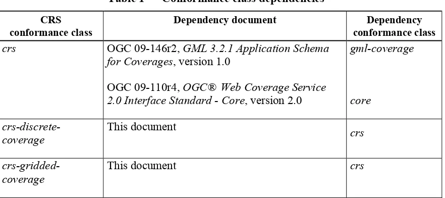
Table 1 — Conformance class dependencies
CRS conformance class
Dependency document Dependency conformance class crs OGC 09-146r2, GML 3.2.1 Application Schema
for Coverages, version 1.0
OGC 09-110r4, OGC® Web Coverage Service 2.0 Interface Standard - Core, version 2.0
gml-coverage
This document crs
4 Terms and definitions
For the purposes of this document, the terms and definitions given in the above references apply. In addition, the following terms and definitions apply. An arrow ““ indicates that the following term is defined in this Clause.
4.1 CRS
Coordinate Reference System
4.2 Native CRS [of a coverage]
3 Copyright © 2014 Open Geospatial Consortium.
4.3 CRS Identifier
URL, conforming to the OGC CRS Name Type Definition [OGC 11-135], which resolves to a well-known CRS
Example 1 WGS84 has this CRS Name registered with OGC-NA [2]: http://www.opengis.net/def/crs/EPSG/0/4326
Example 2 A hypothetical temporal CRS1 might have this CRS Name registered with OGC-NA: http://www.opengis.net/def/crs/OGC/1.0/Gregorian-Date
Example 3 A 3-dimensional CRS with dimensions latitude, longitude, and time can be represented as follows, according to the OGC CRS Name Type Definition:
http://www.opengis.net/def/crs-compound?
1=http://www.opengis.net/def/crs/EPSG/0/4326
&2=http://www.opengis.net/def/crs/OGC/1.0/Gregorian-Date
5 Conventions
5.1 UML notation
Unified Modeling Language (UML) static structure diagrams appearing in this specification are used as described in Subclause 5.2 of OGC Web Services Common [OGC 06-121r9].
5.2 Data dictionary tables
The UML model data dictionary is specified herein in a series of tables. The contents of the columns in these tables are described in Subclause 5.5 of [OGC 06-121r9]. The contents of these data dictionary tables are normative, including any table footnotes.
5.3 Namespace prefix conventions
The following namespaces are used in this document. The prefix abbreviations used constitute conventions used here, but are not normative. The namespaces to which the prefixes refer are normative, however.
Table 2— Namespace mappings
Prefix Namespace URI Description
xsd http://www.w3.org/2001/XMLSchema XML Schema namespace gml http://www.opengis.net/gml/3.2 GML 3.2.1
gmlcov http://www.opengis.net/gmlcov/1.0 GML Application Schema for Coverages 1.0
OGC 11-053r1
4 Copyright © 2014 Open Geospatial Consortium.
wcs http://www.opengis.net/wcs/2.0 WCS 2.0 Core
crs http://www.opengis.net/wcs/crs/1.0 this WCS 2.0 CRS Extension
5.4 Multiple representations
When multiple representations of the same information are given in a specification document these are consistent. Should this not be the case then this is considered an error, and the XML schema shall take precedence.
6 Crs requirements class
6.1 Overview
Clients and servers supporting this CRS extension are CRS aware, that is: they can request and deliver coverages in CRSs other than only the one in which they are originally stored. A server announces both CRS support and the concrete CRSs known in the Capabilities document; a client can request delivery of a coverage obtained through a GetCoverage request in one of these CRSs announced by the server.
This Clause 6 establishes the CRS Extension core conformance class, crs, which defines how Web Coverage Services shall deal with CRSs.
6.2 Modifications to GetCapabilities
A server announces support of the CRS extension to a client by adding the URL identifying this extension to the list of supported extensions delivered in the Capabilities document.
Requirement 1 crs/extension-identifier:
A WCS service implementing conformance class crs of this CRS Extension shall include the following URI in the Profile element of the ServiceIdentification in a
GetCapabilities response:
http://www.opengis.net/spec/WCS_service-extension_crs/1.0/conf/crs
Dependency: WCS Core [OGC 09-110r4],
http://www.opengis.net/spec/WCS/2.0/req/core
A Crs item is added to the WCS service metadata using the extension mechanism provided by the WCS Core [OGC 09-110r3]. In its crsSupported component it contains the list of CRSs in which the server can return coverages.
Requirement 2 crs/capabilities-crs:
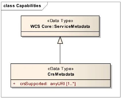
The response to a successful GetCapabilities request shall adhere to Figure 1, Table 3, and the XML schema defined for this CRS Extension.
5 Copyright © 2014 Open Geospatial Consortium.
Figure 1 —Capabilities UML diagram with CrsMetadata component
Table 3 — Components of CRS::CRS structure
Name Definition Data type Multiplicity
crsSupported Identifiers of CRSs a result coverage can bear
List of anyURI one or more (optional)
Requirement 3 crs/wcsServiceMetadata-crs:
The response to a successful GetCapabilities request shall contain a crs:CrsMetadata element in the wcs:Extension element of wcs:ServiceMetadata.
Requirement 4 crs/wcsServiceMetadata-outputCrs:
The crsSupported item(s) delivered in the CrsMetadata element of the response to a successful GetCapabilities request shall consist of URLs, each one resolving to an
instantiatable subtype of GML::AbstractCRS.
Note This does not per se mean that every CRS reported in the Capabilities document is applicable to every coverage available from the server or to every possible trim or slice subset of such a coverage. For example, a server may offer 2D and 3D coverages, in which case 2D coverages cannot be retrieved in a 3D CRS, and vice versa. Further, 2D slices from a 3D coverage cannot be returned in a 3D CRS, but require a 2D output CRS.
Requirement 5 crs/wcsServiceMetadata-outputCrs-unique:
The list of crsSupported element(s) delivered in the CrsMetadata element of the response to a successful GetCapabilities request shall not contain any duplicates. A client should not assume that a CRS list is delivered in some particular order.
6.3 Modifications to DescribeCoverage
OGC 11-053r1
6 Copyright © 2014 Open Geospatial Consortium.
6.4 Modifications to GetCoverage
6.4.1 Modifications to the GetCoverage request
The GetCoverage request is extended with two optional parameters indicating the CRSs for subsetting coordinates and for the result coverage. If these parameters are omitted then all access will be performed in the coverage’s Native CRS (as reported in its Coverage Description).
Note This normally ensures that the coverage’s unchanged range set values are retrieved, assuming that no other operations than subsetting is performed in the GetCoverage request.
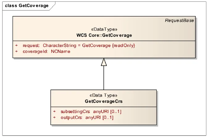
Requirement 6 crs/getCoverage-crs:
A GetCoverage request shall adhere to Figure 2, Table 4, and the XML schema defined for this CRS Extension whereby, in the XML request encoding, the GetCoverage wcs:Exten-sion element shall contain exactly one GetCoverageCrs element.
Figure 2 —GetCoverage UML diagram with GetCoverageCRS extension
Table 4 — Components of CRS::GetCoverageCrs structure
Name Definition Data type Multiplicity
subsettingCrs CRS Identifier indicating the CRS in which the request subsetting
coordinates are expressed
anyURI zero or one (optional)
outputCrs CRS Identifier indicating the CRS of the result coverage
anyURI zero or one (optional)
7 Copyright © 2014 Open Geospatial Consortium.
Requirement 7 crs/getCoverage-subsettingCrs-default:
If the subsettingCrs parameter is not present in a GetCoverage request then the request
shall be evaluated as if a subsettingCrs parameter equal to the coverage’s Native CRS (as provided in the Coverage Description) had been provided.
Requirement 8 crs/getCoverage-subsettingCrs-uniqueCrsName:
The subsettingCrs parameter in a GetCoverage request, if present, shall have as its value a CRS Identifier.
Requirement 9 crs/getCoverage-subsettingCrs-availableCrs:
The subsettingCrs parameter in a GetCoverage request, if present, shall have as its value a CRS Identifier described in the crsSupported list delivered in the CrsMetadata element of the Capabilities document of the server addressed.
Note As per WCS Core [OGC 09-110r3] every coverage has a Native CRS associated which will be contained in this list among potentially more CRSs; therefore, this list will never be empty as long as the server offers at least one coverage.
A GetCoverage request may contain an additional parameter, outputCrs, to indicate a particular CRS in which the client wants to receive the result coverage produced by the server. Admissible values for this parameter are URIs which resolve to exactly one CRS.
Requirement 10crs/getCoverage-outputCrs-default:
If the outputCrs parameter is not present in a GetCoverage request then the request shall
be evaluated as if an outputCrs parameter equal to the subsettingCrs parameter value assumed for this request’s evaluation had been provided.
Requirement 11crs/getCoverage-outputCrs-uniqueCrsName:
The outputCrs parameter in a GetCoverage request, if present, shall have as its value a CRS Identifier.
Requirement 12crs/getCoverage-outputCrs-availableCrs:
The outputCrs parameter in a GetCoverage request, if present, shall have as its value a CRS Identifier described in the crsSupported list delivered in the CrsMetadata element of the Capabilities document of the server addressed.
Note As per WCS Core [OGC 09-110r3] every coverage has a Native CRS associated which will be in this list among potentially more CRSs; therefore, this list will never be empty as long as the server offers at least one coverage.
6.4.2 Modifications to the GetCoverage response
Requirement 13crs/getCoverage-response-crs:
The contents of the response to a successful GetCoveragerequest containing an outputCrs parameter shall have, in the gml:boundedBy element, an srsName value identical to the outputCrs element in the request.
Example The following is a valid srsName specification:
<gml:boundedBy ... srsName=”http://www.opengis.net/def/crs/EPSG/0/4326” ...>
OGC 11-053r1
8 Copyright © 2014 Open Geospatial Consortium.
No statement is made in this specification about the interpolation method applied by the server in the course of the CRS transformation. A server is free to employ any interpolation method during CRS transformation, and information about the interpolation applied may not be accessible to the client. While the interpolation method applied may change over requests, and different interpolation methods may be applied to different range components of a particular coverage, a server should not change interpolation across the domain of coverage during execution of a single coverage CRS transformation.
Note The WCS Interpolation Extension allows controlling interpolation behaviour.
6.5 Exceptions
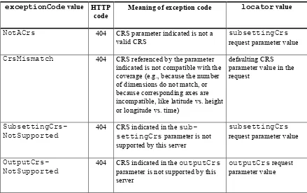
Requirement 14crs/getCoverage-exception:
When a WCS server encounters an error while evaluating the outputCrs parameter in a
GetCoverage operation it shall return an exception report message chosen as indicated in
Table 4. For each listed exceptionCode, the contents of the locator parameter value
shall be as specified in the right column in Table 5.
Table 5 — Exception codes for use of outputCrs exceptionCode value HTTP
code
Meaning of exception code locator value
NotACrs 404 CRS parameter indicated is not a valid CRS
subsettingCrs
request parameter value
CrsMismatch 404 CRS referenced by the parameter indicated is not compatible with the coverage (e.g., because the number of dimensions do not match, or because corresponding axes are incompatible, like latitude vs. height or longitude vs. time)
defaulting CRS parameter value in the request
SubsettingCrs-NotSupported
404 CRS indicated in the sub-settingCrs parameter is not supported by this server
subsettingCrs
request parameter value
OutputCrs-NotSupported
404 CRS indicated in the outputCrs
parameter is not supported by this server
outputCrs request parameter value
6.6 Encodings
6.5.1 GET/KVP Encoding
Requirement 15crs/getCoverage-getkvp-subsettingcrs:
9 Copyright © 2014 Open Geospatial Consortium. SUBSETTINGCRS=s
where s is a URL.
Example The following is a valid KVP fragment, assuming that the coverage addressed has a lat and long axis:
…& SUBSETTINGCRS=http://www.opengis.net/def/crs/EPSG/0/4326 &…
Requirement 16crs/getCoverage-outputcrs:
In a GetCoverage request using the GET/KVP protocol, a Crs::outputCrs parameter shall be represented as
OUTPUTCRS=s where s is a URL.
Example The following is a valid KVP fragment, assuming that the coverage addressed has a lat and longaxis:
…& OUTPUTCRS=http://www.opengis.net/def/crs/EPSG/0/4326 &…
6.5.2 XML/POST Encoding
Requirement 17crs/getCoverage-xmlpost:
In a GetCoverage request using the XML/POST protocol, a Crs::GetCoverageCrs parameter shall be represented by a crs::GetCoverageCrs element.
Example The XML fragments below resemble the same example cases as the GET/KVP fragments above.
<wcs:Extension> <wcscrs:outputCrs>
http://www.opengis.net/def/crs/EPSG/0/4326
</wcscrs:outputCrs> </wcs:Extension>
<wcs:Extension>
<wcscrs:subsettingCrs>
http://www.opengis.net/def/crs/EPSG/0/4326
</wcscrs:subsettingCrs> <wcscrs:outputCrs>
http://www.opengis.net/def/crs/EPSG/0/4326 </wcscrs:outputCrs>
</wcs:Extension>
6.5.3 SOAP Encoding
Requirement 18crs/getCoverage-soap:
In a GetCoverage request using the SOAP protocol, a Crs::GetCoverageCrs parameter shall be represented by a crs::GetCoverageCrs element.
OGC 11-053r1
10 Copyright © 2014 Open Geospatial Consortium.
7 Crs-gridded-coverage requirements class
7.1 Overview
This Clause 7 establishes the CRS Extension conformance class crs-gridded-coverage which defines how Web Coverage Services shall deal with CRSs when Grid Coverages (in the definition of GML 3.2.1 [OGC 09-146r1]) are addressed.
Note As per GML 3.2.1 [OGC 09-146r1], this encompasses the coverage classes GML::Grid-Coverage, GML::RectifiedGridCoverage, and GML::ReferenceableGrid-Coverage.
Requirement 19crs-gridded-coverage/dependency:
A WCS service implementing conformance class crs-gridded-coverage of this CRS Extension shall also implement the crs conformance class of this CRS Extension.
Dependency:
Clause 6, http://www.opengis.net/doc/IS/WCS_service-extension_crs/1.0/Clause-6
7.2 Modifications to GetCapabilities
Requirement 20crs-gridded-coverage/extension-identifier:
A WCS service implementing conformance class crs-gridded-coverage of this CRS Extension shall include the following URI in the Profile element of the
ServiceIdentification in a GetCapabilities response:
http://www.opengis.net/spec/WCS_service-extension_crs/1.0/conf/crs-gridded-coverage
7.3 Modifications to GetCoverage
For Grid Coverages, a conceptual evaluation model is specified. Implementations can choose to employ different algorithms as long as the result data are identical.
Requirement 21crs-gridded-coverage/getCoverage-rangeSet:
The range values of the response to a successful GetCoverage request containing an outputCrs parameter shall be determined according to the following conceptual evaluation model: Take the bounding box of the request’s subsetting parameter (or the full coverage bounding box if no subsetting was specified in the request); re-project this bounding box to the output CRS provided; generate the result image extent as the smallest bounding box around the reprojected subsetting box; fill this new image extent with pixel values re-projected from the coverage’s Native CRS to the output CRS in a way that, for each axis, the smallest distance between any two reprojected grid points is used as offset
(including all interpolation and resampling necessary) unless specified otherwise by further request parameters.
11 Copyright © 2014 Open Geospatial Consortium.
8 Crs-discrete-coverage requirements class
8.1 Overview
This Clause 8 establishes the CRS Extension conformance class crs-discrete-coverage which defines how Web Coverage Services shall deal with CRSs when Discrete Coverages (in the definition of GML 3.2.1 [OGC 09-146r1]) are addressed.
Note As per GML 3.2.1 [OGC 09-146r1], the GML::DiscreteCoverageclass consists of the coverage sub-classes GML::MultiPointCoverage, GML::MultiCurveCoverage, GML::MultiSurfaceCoverage, and GML::MultiSolidCoverage.
Requirement 22crs-discrete-coverage/dependency:
A WCS service implementing conformance class crs-discrete-coverage of this CRS Extension shall also implement the crs conformance class of this CRS Extension.
Dependency:
Clause 6, http://www.opengis.net/doc/IS/WCS_service-extension_crs/1.0/Clause-6
8.2 Modifications to GetCapabilities
Requirement 23crs-discrete-coverage/extension-identifier:
A WCS service implementing conformance class crs-discrete-coverage of this CRS Extension shall include the following URI in the Profile element of the
ServiceIdentification in a GetCapabilities response:
http://www.opengis.net/spec/WCS_service-extension_crs/1.0/conf/crs-discrete-coverage
Note Currently, no particular requirements are imposed. Further revisions of this standard may add ones, though.
8.3 Modifications to GetCoverage
For Discrete Coverages, a conceptual evaluation model is specified. Implementations can choose to employ different algorithms as long as the result data are identical.
Requirement 24crs-gridded-coverage/getCoverage-rangeSet:
The range values of the response to a successful GetCoverage request containing an outputCrs parameter shall be determined according to the following conceptual evaluation model: Take the bounding box of the request’s subsetting parameter (or the full coverage bounding box if no subsetting was specified in the request); re-project this bounding box to the output CRS provided; generate the result image extent as the smallest bounding box around the reprojected subsetting box; fill this new image extent with pixel values re-projected from the coverage’s Native CRS to the output CRS in a way that, for each axis, the smallest distance between any two reprojected grid points is used as offset
(including all interpolation and resampling necessary) unless specified otherwise by further request parameters.
OGC 11-053r1
12 Copyright © 2014 Open Geospatial Consortium.
Bibliography
[1] ISO 8601:2004(E) Data elements and interchange formats — Information interchange — Representation of dates and time
13 Copyright © 2014 Open Geospatial Consortium.
Annex A (normative)
Abstract test suite
A CRS Extension implementation must satisfy the following system characteristics to be conformant with this specification.
Test identifiers below are relative to http://www.opengis.net/spec/WCS/2.0/WCS_service-extension_crs/1.0/conf.
A.1
Conformance Test Class:
crs
The OGC URI identifier of this conformance class is:
http://www.opengis.net/spec/WCS/2.0/conf/WCS_service-extension_crs/1.0/conf/crs.
A.1.1
CRS extension identifier
Test id: Test Purpose:
crs/extension-identifier:
A WCS service implementing conformance class crs of this CRS Extension
shall include the following URI in the Profile element of the ServiceIdentification in a GetCapabilities response:
http://www.opengis.net/spec/WCS_service-extension_crs/1.0
Test method: Determine the supported extension via a valid GetCapabilities request; check that the URI required is listed accordingly.
Test passes if all individual tests pass.
A.1.2
Capabilities
Test id: Test Purpose:
crs/capabilities-crs:
The response to a successful GetCapabilities request shall adhere to Figure 1, Table 3, and the XML schema defined for this CRS Extension.
Test method: Send a valid GetCapabilitiesrequest to the server under test, check the result consists of the appropriate components, as defined in the places referenced.
Test passes if all individual tests pass.
A.1.3
CrsMetadataelement
Test id: Test Purpose:
crs/wcsServiceMetadata-crs:
OGC 11-053r1
14 Copyright © 2014 Open Geospatial Consortium.
Test method: Send a valid GetCapabilities request to the server under test, check the result consists of a CrsMetadata element.
Test passes if all individual tests pass.
A.1.4
Output CRS
Test id: Test Purpose:
crs/wcsServiceMetadata-outputCrs:
The crsSupported item(s) delivered in the CrsMetadata element of the response to a successful GetCapabilities request shall consist of URLs, each one resolving to an instantiatable subtype of GML::AbstractCRS.
Test method: Send a valid GetCapabilities request to the service under test. Check that the crsSupported item(s) delivered in the CrsMetadata element of the response consist of URLs, each one resolving to an instantiatable subtype of GML::AbstractCRS.
Test passes if all individual tests pass.
A.1.5
Unique output CRS
Test id: Test Purpose:
crs/wcsServiceMetadata-outputCrs-unique:
The list of crsSupported element(s) delivered in the CrsMetadata element of the response to a successful GetCapabilities request shall not contain any duplicates.
Test method: Send a valid GetCapabilities request to the service under test. Check that the crsSupported item(s) delivered in the CrsMetadata element of the response do not contain any duplicates.
Test passes if all individual tests pass.
A.1.6
GetCoverage CRS
Test id: Test Purpose:
crs/getCoverage-crs:
A GetCoverage request shall adhere to Figure 2, Table 4, and the XML schema defined for this CRS Extension whereby, in the XML request encoding, the GetCoverage wcs:Extension element shall contain exactly one GetCoverageCrs element.
Test method: Send a valid GetCoverage request to server under test which conforms to the references in the requirement. Check that the response is not an exception.
15 Copyright © 2014 Open Geospatial Consortium.
A.1.7
Service Metadata Output CRS
Test id: Test Purpose:
crs/wcsServiceMetadata-outputCrs:
The crsSupported item(s) delivered in the CrsMetadata element of the response to a successful GetCapabilities request shall consist of URLs, each one resolving to an instantiatable subtype of GML::AbstractCRS.
Test method: Send a valid GetCoverage request without the subsettingCrs parameter to the service under test. Check that the response coverage is evaluated according to its Native CRS (as provided in the Coverage Description). Test passes if all individual tests pass.
A.1.8
Unique GetCoverageSubsettingCrs CRS
Test id: Test Purpose:
crs/getCoverage-subsettingCrs-uniqueCrsName:
The subsettingCrs parameter in a GetCoverage request, if present,
shall have as its value a CRS Identifier.
Test method: Send valid GetCoverage requests with a subsettingCrs parameter to server under test where the parameter contains
a CRS Identifier (as provided in the CrsMetadata element of the Capabilities document);
two or more CRS Identifiers.
Pass test if appropriate valid results or exceptions, resp., are delivered
A.1.9
Available GetCoveragesubsettingCRS
Test id: Test Purpose:
crs/getCoverage-subsettingCrs-availableCrs:
The subsettingCrs parameter in a GetCoverage request, if present,
shall have as its value a CRS Identifier described in the crsSupported list delivered in the CrsMetadata element of the Capabilities document of the server addressed.
Test method: Send valid GetCoverage requests with a subsettingCrs parameter to server under test where the parameter contains
a CRS Identifier which is in the crsSupportedlist delivered in the CrsMetadata element of the Capabilities document of the server addressed;
OGC 11-053r1
16 Copyright © 2014 Open Geospatial Consortium.
Pass test if appropriate valid results or exceptions, resp., are delivered.
A.1.10
Default GetCoverageOutputCRS
Test id: Test Purpose:
crs/getCoverage-outputCrs-default:
If the outputCrs parameter is not present in a GetCoverage request then the request shall be evaluated as if an outputCrs parameter equal to the subsettingCrs parameter value assumed for this request’s evaluation had been provided.
Test method: Send a valid GetCoverage request without the outputCrs parameter to the service under test. Check that the response coverage is provided according to the subsettingCrs parameter value assumed for this request’s evaluation had been provided.
Test passes if all individual tests pass.
A.1.11
Unique GetCoverageOutputCRS
Test id: Test Purpose:
crs/getCoverage-outputCrs-uniqueCrsName:
The outputCrs parameter in a GetCoverage request, if present, shall
have as its value a CRS Identifier.
Test method: Send valid GetCoverage requests with an outputCrs parameter to server under test where the parameter contains
a CRS Identifier (as provided in the CrsMetadata element of the Capabilities document);
two or more CRS Identifiers.
Pass test if appropriate valid results or exceptions, resp., are delivered.
A.1.12
Available GetCoverageoutputCRS
Test id: Test Purpose:
crs/getCoverage-outputCrs-availableCrs:
The outputCrs parameter in a GetCoverage request, if present, shall
have as its value a CRS Identifier described in the crsSupported list delivered in the CrsMetadata element of the Capabilities document of the server addressed.
Test method: Send valid GetCoverage requests with an outputCrs parameter to server under test where the parameter contains
17 Copyright © 2014 Open Geospatial Consortium. addressed;
a CRS Identifier which is not in the crsSupported list.
Pass test if appropriate valid results or exceptions, resp., are delivered.
A.1.13
GetCoverage Response CRS
Test id: Test Purpose:
crs/getCoverage-response-crs:
The contents of the response to a successful GetCoveragerequest containing an outputCrs parameter shall have, in the gml:boundedBy element, an srsName value identical to the outputCrs element in the request.
Test method: Send a valid GetCoverage request with an outputCrs parameter to the service under test. Check that a srsNameof the gml:boundedBy element of the response coverage is identical to the outputCrselement in the request.
Test passes if all individual tests pass.
A.1.14
GetCoverage Exception
Test id: Test Purpose:
crs/getCoverage-exception:
When a WCS server encounters an error while evaluating the outputCrs parameter in a GetCoverage operation it shall return an exception report message chosen as indicated in Table 4. For each listed exceptionCode, the contents of the locator parameter value shall be as specified in the right column in Table 5.
Test method: For each exception referenced in the requirement: Send an erroneous GetCoverage request to the server under test provoking this exception, as per its definition. Check for proper exception reporting. Pass test if all checks succeed.
Test passes if all individual tests pass.
A.1.15
GetCoverageGetKVPSubsettingcrs
Test id: Test Purpose:
crs/getCoverage-getkvp-subsettingcrs:
In a GetCoverage request using the GET/KVP protocol, a Crs::subsettingCrs parameter shall be represented as
SUBSETTINGCRS=s where s is a URL.
Test method: Send a valid GetCoverage request in GET/KVP with the Crs::subsettingCrs parameter being represented as
OGC 11-053r1
18 Copyright © 2014 Open Geospatial Consortium.
exception.
Test passes if all individual tests pass.
A.1.16
GetCoverageOutputCRS
Test id: Test Purpose:
crs/getCoverage-outputcrs:
In a GetCoverage request using the GET/KVP protocol, a Crs::outputCrs parameter shall be represented as
OUTPUTCRS=s where s is a URL.
Test method: Send a valid GET/KVP GetCoverage request with the Crs::outputCrs parameter being represented as OUTPUTCRS=s where s is a URL. Check that the result is not an exception.
Test passes if all individual tests pass.
A.1.17
GetCoverage XML/POST
Test id: Test Purpose:
crs/getCoverage-xmlpost:
In a GetCoverage request using the XML/POST protocol, a Crs::GetCoverageCrs parameter shall be represented by a crs::GetCoverageCrs element.
Test method: Send a valid XML/POST GetCoverage request with the
crs::GetCoverageCrs element. Check that the result is not an exception.
Test passes if all individual tests pass.
A.1.18
GetCoverage SOAP
Test id: Test Purpose:
crs/getCoverage-soap:
In a GetCoverage request using the SOAP protocol, a
Crs::GetCoverageCrs parameter shall be represented by a crs::GetCoverageCrs element.
Test method: Send a valid SOAP GetCoverage request with the crs::GetCoverage-Crs element. Check that the result is not an exception.
Test passes if all individual tests pass.
A.2
Conformance Test Class:
crs-gridded-coverage
The OGC URI identifier of this conformance class is:
19 Copyright © 2014 Open Geospatial Consortium.
A.2.1
CRS Gridded Coverage Dependency
Test id: Test Purpose:
crs-gridded-coverage/dependency:
A WCS service implementing conformance class crs-gridded-coverage of this CRS Extension shall also implement the crs conformance class of this CRS Extension.
Dependency:
Clause 6, http://www.opengis.net/doc/IS/WCS_service-extension_crs/1.0/Clause-6
Test method: Determine the supported dependency via a valid GetCapabilities request; check that the URI required is listed accordingly.
Test passes if all individual tests pass.
A.2.2
Gridded Coverage CRS
Test id: Test Purpose:
crs-gridded-coverage/extension-identifier:
A WCS service implementing conformance class crs-gridded-coverage of this CRS Extension shall include the following URI in the Profile
element of the ServiceIdentification in a GetCapabilities response:
http://www.opengis.net/spec/WCS_service-extension_crs/1.0/conf/crs-gridded-coverage
Test method: Determine the supported extension via a valid GetCapabilities request; check that the URI required is listed accordingly.
Test passes if all individual tests pass.
A.2.3
GetCoverage Range Set
Test id: Test Purpose:
crs-gridded-coverage/getCoverage-rangeSet:
The range values of the response to a successful GetCoverage request containing an outputCrs parameter shall be determined according to the following conceptual evaluation model: Take the bounding box of the request’s subsetting parameter (or the full coverage bounding box if no subsetting was specified in the request); re-project this bounding box to the output CRS provided; generate the result image extent as the smallest bounding box around the reprojected subsetting box; fill this new image extent with pixel values re-projected from the coverage’s Native CRS to the output CRS in a way that, for each axis, the smallest distance between any two reprojected grid points is used as offset (including all interpolation and resampling necessary) unless specified otherwise by further request
parameters.
Test method: Send valid GetCoverage requests to server under test without a subsettingCrs parameter;
OGC 11-053r1
20 Copyright © 2014 Open Geospatial Consortium.
provided in the CrsMetadata element of the Capabilities document); without an outputCrs parameter;
with an outputCrs parameter contains a CRS Identifier (as provided in the CrsMetadata element of the Capabilities document).
Check that these results are evaluated according to the specified model. Test passes if all individual tests pass.
A.3
Conformance Test Class:
crs-discrete-coverage
The OGC URI identifier of this conformance class is:
http://www.opengis.net/spec/WCS/2.0/conf/WCS_service-extension_crs/1.0/conf/crs-discrete-coverage.
A.3.1
CRS Discrete Coverage Dependency
Test id: Test Purpose:
crs-discrete-coverage/dependency:
A WCS service implementing conformance class crs-discrete-coverage of this CRS Extension shall also implement the crs conformance class of this CRS Extension.
Dependency:
Clause 6, http://www.opengis.net/doc/IS/WCS_service-extension_crs/1.0/Clause-6
Test method: Determine the supported dependency via a valid GetCapabilities request; check that the URI required is listed accordingly.
Test passes if all individual tests pass.
A.3.2
Crs Discrete Coverage Identifier
Test id: Test Purpose:
crs-discrete-coverage/extension-identifier:
A WCS service implementing conformance class crs-discrete-coverage of this CRS Extension shall include the following URI in the Profile
element of the ServiceIdentification in a GetCapabilities response:
http://www.opengis.net/spec/WCS_service-extension_crs/1.0/conf/crs-discrete-coverage
Test method: Determine the supported extension via a valid GetCapabilities request; check that the URI required is listed accordingly.
Test passes if all individual tests pass.
A.3.3
Crs Discrete Coverage Range Set
21 Copyright © 2014 Open Geospatial Consortium.
Test Purpose: The range values of the response to a successful GetCoverage request containing an outputCrs parameter shall be determined according to the following conceptual evaluation model: Take the bounding box of the request’s subsetting parameter (or the full coverage bounding box if no subsetting was specified in the request); re-project this bounding box to the output CRS provided; generate the result image extent as the smallest bounding box around the reprojected subsetting box; fill this new image extent with pixel values re-projected from the coverage’s Native CRS to the output CRS in a way that, for each axis, the smallest distance between any two reprojected grid points is used as offset (including all interpolation and resampling necessary) unless specified otherwise by further request
parameters.crs-discrete-coverage/extension-identifier:
A WCS service implementing conformance class crs-discrete-coverage of this CRS Extension shall include the following URI in the Profile
element of the ServiceIdentification in a GetCapabilities response:
http://www.opengis.net/spec/WCS_service-extension_crs/1.0/conf/crs-discrete-coverage
Test method: Send valid GetCoverage requests to server under test without a subsettingCrs parameter;
with a subsettingCrs parameter contains a CRS Identifier (as provided in the CrsMetadata element of the Capabilities document); without an outputCrs parameter;
with an outputCrs parameter contains a CRS Identifier (as provided in the CrsMetadata element of the Capabilities document).
Check that these results are evaluated according to the specified model. Test passes if all individual tests pass.