GEOPACKAGE DATA FORMAT FOR COLLABORATIVE MAPPING OF GEOSPATIAL
DATA IN LIMITED NETWORK ENVIRONMENTS
M. H. Rashidan, I. A. Musliman , A. A. Rahman
Department of Geoinformation, Faculty of Geoinformation and Real Estate, Universiti Teknologi Malaysia, 81310, Johor, Malaysia - (ivinamri, alias)@utm.my
KEY WORDS: Collaborative Mapping, GeoPackage, Mobile GIS, Field Data Collector
ABSTRACT:
With the growth of technology in earth and space science informatics has led to the revolution in a wide range of geospatial practice. Nowadays collaborative mapping has become a new hot spot, following mobile and web GIS. This paper explores the potential use of GeoPackage for collaborative mapping of geospatial data in limited network environments. GeoPackage is a data format that open-standard, platform-independent, portable, and self-describing. This paper focus on the implementation of GeoPackage in mobile application for field data collection. A mobile application was developed that implements the GeoPackage data format as an internal database to provide support for offline mapping. The developed mobile application demonstrates that vector and raster data can be stored in a single data format, which reduces the device storage consumption. The details of how GeoPackage data contribute to mobile GIS to achieve collaborative mapping in limited network environments are discussed. The findings show that the GeoPackage data format has great potential to improve existing mobile GIS applications.
1. INTRODUCTION
1.1 Collaborative Mapping
Collaborative mapping is an initiative to collectively create mod- els of real-world features online, then allow users to access and use to virtually annotate locations in space. It is known as a meth- ods of generating content on the Internet, which involves contri- butions from group of individuals or entities, and can take sev- eral distinct forms. With the growth of technology for creating and sharing maps, collaborative mapping have become a good initiation to incorporate new applications particularly in spatial information dissemination (Jokar Arsanjani and Vaz, 2015). The mapping applications vary depending on which feature the col- laborative edition takes place: whether on the map itself (shared surface), or on overlays to the map (feature overlaid). A very simple collaborative mapping application would just plot users’ locations on maps (OpenLayers, Google Map and etc.). In this kind of application, the map itself is created collaboratively by sharing a common surface, thus benefits to identify areas of share knowledge, reduce duplication of efforts, share knowledge of in- terest, and develop new innovative ideas to address challenges. Thus, mapping of geospatial data nowadays have become easier and social adapted.
At the moment, the emerging geospatial sharing technologies in earth and space science informatics has led to the transforming practice in a wide array of disciplines, from the increasing use of desktop GIS, to distributed GIS (web), and ubiquitous GIS (mo- bile). At present, geospatial mobile applications are appearing at an increasingly rapid pace, such as in enhancements to uni- fied critical communication suites (Business Wire, 2014), leak- age management systems (MENA Report, 2013), real-time field surveys (Jeefoo, 2014), communication networks for disaster- damaged areas (Youhei et al., 2014), smart eco-path finders for mobile users (Lwin and Murayama, 2013), time cost optimiza- tion for mobile GIS queries (Haifa et al., 2012) and so forth. These patterns show mobile applications have become an impor- tant components in geospatial technologies.
Many mobile GIS (proprietary or open source) were developed by large group of companies and non-profit agencies offer mobile applications which support for outdoor mapping works. Field data collector utilize such application to collect geospatial data for asset mapping, management, or monitoring. Some of the developed mobile applications comes with an advanced features such as ability to access multiple hosting database in real-time, supports for online and offline editing, and integrates with ad- vanced positioning technology. However, mobile GIS still faces challenges in certain aspects like multiple datasets are stored as individual file format in mobile device, thus lead to contain re- dundant geospatial data which consuming large storage capacity. Also, the application requiring custom applications for data trans- lation, replication and synchronization to enable different appli- cations to share the same view (OGC, 2015c).
In mobile applications, the collaborative mapping takes place when the map is generated collaboratively from multiple data sources (overlays on map). Locations and spatial information can be ac- cessed by users through the map, and users able to query infor- mation, insert new data, or update the map in real-time or offline. Before this, mobile GIS data mapping is highly depends on the Internet connection to operates, this is due to tight communica- tion between server and client. Previous method used in offline mapping for mobile application is through temporary datasets created (retrieved from online database) and stored in local de- vice. Any changes that are applied to the datasets will be updates to the main database when the Internet is accessible. This allows mapping can be carried out despite in the absence of an Internet connection.
1.2 Mapping in Mobile Environments
Mobile GIS, a cross-research field integrating modern mobile com- puting techniques with geographic information science, has at- tracted more and more researchers in exploring and developing new practices in spatial mobile application. It is built on mo- bile terminal environments of limited capacity, providing mov- ing, distributed and flexible mobile geographic information ser- vices. Specifically, mobile GIS is based on embedded GIS inte- gration with positioning technology, mobile communication tech- nology, and wireless Internet technology to expand the GIS ap- plication, and improve GIS information collection, management and analysis (Li, 2009).
Further development of technology in related fields has lead mo- bile GIS to be expanded its application areas in various disci- plines. For instance many mobile applications were developed to support collaborative mapping, and some of these applications are meant for data collection and public services. Previously, mobile GIS for field data collection faced the problems of not working because of the absence of an Internet connection. When access to the database server was interrupted, the mapping pro- cess was delayed. However, many mobile GIS developers have developed an improved mobile application that offers the abil- ity to operate in limited network environments. This is achieved through temporarily storing required datasets in the mobile de- vice. Any changes and updates made to the temporary datasets will be sent back to the database server for updates.
Leaders in GIS industry are actively involved in research of mo- bile GIS and have launched related products on the data collec- tion which support for offline mapping. Among them are ES- RIs ArcPad - a mobile field mapping and data collection software designed for GIS professionals; WebMapSolutions - has experi- enced building offline mobile GIS apps for over 4 years; GIS2GO - offline GIS app on mobile tablet; Mappt - an agile data capture and management tool used on Android platform with advanced map caching; ASTECs Gislet - an online and offline mobile GIS for data collection; MB&Gs MobileMap - a mobile field data col- lection with offline GIS capabilities; and many more.
In collaborative mapping, problem arise when several geospatial datasets are needed to assist the mapping activity, these datasets are downloaded and stored temporarily in the mobile device. This will introduced problems like application to be slowed, hanged or crashed. The reasons are mobile applications are not design in- tended to handle the massive spatial data processing request and large amount of datasets. A good mobile application for collabo- rative mapping should be lightweight and able to perform spatial process fluently. Therefore, even the current mobile applications are supported for offline editing, it is still limited to a certain in- stances.
The other issue in mobile applications are some geospatial data are stored in individual file format. This will introduces to data duplication and redundancy at the same time consuming large storage capacity. For example, sometime mapping works requires access to wide range of spatial data (vector and raster), which may consisting several types of spatial data formats. These data formats have their own use and advantage, and some of them are not suitable for mobile application. Currently the data formats that are likely to be used in mobile applications are Shapefile, Keyhole Markup Language (KML or KMZ), AutoCAD DXF, Spatial Data Transfer Standard (SDTS), MDB Geodatabase (ES- RIs ArcGIS), GeoJSON, GeoCSV, MBTiles and JPEG2000. Some of these data formats are open standard, and some of them are proprietary data format.
In this paper, new data format called GeoPackage is utilized and implemented in the mobile application development for collabo- rative mapping of geospatial data (utility mapping). The details of how GeoPackage data contributes to mobile GIS to archive collaborative mapping in limited network environments are dis- cussed and presented details. The more mobile devices to support their work and personal lives. Based on these trends new OGC data format called GeoPackage will enable greater geospa- tial data sharing on mobile devices (Singh et al., 2013). GeoPack- age is an open standard, non-proprietary and platform-independent geospatial data format from the Open Geospatial Consortium (OGC, 2015b). It is may become a modern alternative to formats like Spatial Data Transfer Standard (SDTS) and Shapefile. GeoPack- age was introduced with the purpose of increasing cross-platform interoperability of geospatial applications and web services since
it is built on top of SQLite. Thus it enlarges the potential mar- ket for such applications and services, particularly in resource- constrained computing environments. Furthermore, this format was designed and prototyped following a multi-year, open pro- cess of requirements testing and public input to facilitate widespread adoption and use of a single file format by both commercial and open-source software applications, on enterprise production plat- forms as well as on mobile hand-held devices (OGC, 2015b).
This data format is a single file format with a performance like a spatial database (implement a database schema) along with the convenience of a file-based dataset that can be emailed, shared on a flash drive or burned onto a digital disc. In addition, this format efficiently stores vector geospatial features and/or tile ma- trix sets of earth imagery and raster maps at various scales. It can be directly used in cross-platform geospatial applications, which means it has the ability to access and update data in a native storage format without intermediate format translations. Adding GeoPackage support to an application can be done by an SQL-savvy programmer. Likewise, this data format guarantees the data model and dataset integrity, and is particularly useful on mobile devices in communications environments with limited connectivity and bandwidth.
2.1 Contributes to mobile application
because this data for- mat will improve the existing system since the system is used to deploy and store critical data, such as aerial imagery and building plans, on the emergency workers mobile devices. The advan- tages of using GeoPackage for mobile applications is pointed as follows:
”For other field operations, involving dismounted soldiers or bor- der patrol agents for example, this data format (GeoPackage) will enable interoperable access to satellite, environment, and other geospatial data in both online and offline environments”. (Adams and Suykens, 2013)
Furthermore, GeoPackage can be implemented in web-like mo- bile GIS to improve the functionality and capability of an applica- tion. As Mas et al., (2013) has reported in their study of Geospa- tial Web Services and GIS applications, by using GeoPackage, all geospatial data can be encapsulated into a single file format, and thus can be used in a disconnected environment. GeoPackage can make web GIS applications possible works in offline envi- ronments (client side) when access to the Internet is limited. This data format has shown a huge potential to improve in the way cur- rent mobile GIS application deployment and implementation.
2.2 Current status and implementation
On 13 February 2014, the Open Geospatial Consortium adopted the OGC GeoPackage (GPKG) Encoding Standard. The GeoPack- age standard will make it much easier to exchange and share geospatial (or location) information across different devices, ap- plications and web services. There is an initial charter of the Standards Working Group (SWG) for the GeoPackage, the pur- pose of which is to produce a version 1.0.0 implementation stan- dard. This SWG is focused on defining and documenting a new OGC GeoPackage candidate standard based on the specific con- tributions of existing work as a starting point (OGC, 2015b). The current version of GeoPackage encoding standard is 1.0.2, which uses corrigenda process to make correction to the standard by tracking issues and relying on public feedback (OGC, 2015a). The first corrigendum was focused on the features portion of the standard, and SWG is in the process of producing a second cor- rigendum that will focus on tiles. It is believe this second corri- gendum will further improve the readability of the standard and reduce the risk of misinterpretation.
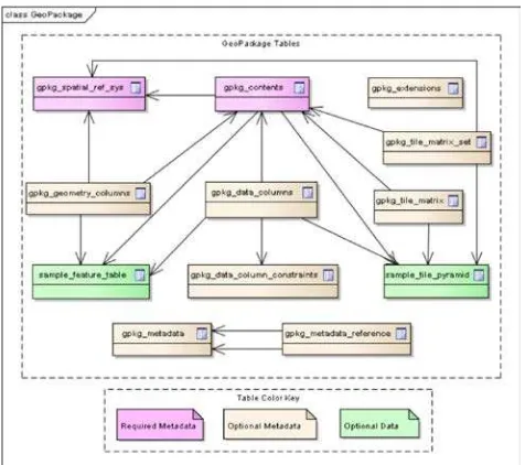
Moreover, this data format is a RDBMS container store with SQL access for simple features with geometry to manage (cre- ate, update, delete as well as search and retrieve) both geospa- tial foundation data for multiple types of features, and newly col- lected feature observation data. The standard defined that every GeoPackage file will have three types of tables; required meta- data, optional metadata and optional data as shown in Figure 1.
2.3 Collaborative mapping in utility mapping Malaysia sce- nario
In Malaysia, the Department of Survey and Mapping Malaysia (DSMM) is the party that responsible in acquiring utility data na- tionwide. The Cabinet of Parliament has decided that the DSMM shall undertake the responsibility of maintaining a repository of all underground utility data, apart from those kept by the vari- ous utility agencies (DSMM, 2006). Maintaining reliable under- ground utility mapping information is an important task in the development, maintenance and upgrading of underground utility infrastructure. Taking into account the increasing instances of catastrophic damages of underground utilities and disruption of existing utility services resulting from excavation works, has led to the establishment of centralized utility database.
Figure 1. GeoPackage tables overview.(Source: OGC GeoPack- age Encoding Standard)
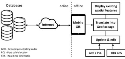
At present, the subsurface utility data is acquired using Ground Penetrating Radar (GPR) and Pipe Cable Locator (PCL). Based on the current workflow shown in Figure 2, the utility mapping works were managed by two survey teams; first team using GPR and PCL to detect subsurface objects, and the second team using GPS to collect position (coordinates). Problem arise during the data updating and merging at desk office since the real situation of collected underground utility objects were presented slightly different from the field, and this introduced inaccuracies in the database (due to re-digitizing and point-to-point joining process by desk officer).
Figure 2. Utility mapping workflow.
Therefore, this paper explores the potential uses of GeoPackage in collaborative mapping of geospatial data in limited network environments using mobile GIS as the platform.
3. METHODOLOGY
3.1 System application framework
The concept used in this system application is based on the utility mapping process (outdoor). The system is designed and devel- oped combining two major components, namely database server and mobile application. Database server is a component which acts as a medium to provide access to the spatial data used by the mobile application. While the mobile application will access the data from the database server through the Internet access. This process involves communication between the database server and the mobile application. In particular, the mapping work involved in this process can be categorized into two parts, online and of- fline. The purpose of providing offline option is because occa- sionally mapping process involve in area with limited network environments. The online part as shown in Figure 3 displays communications between the database server and the mobile ap- plication. The mobile application will send spatial requests to the server, and the server will process the requests and send the re- quired datasets to the mobile application.
For offline part as seen in Figure 3, the obtained required datasets (from database server) are translated into GeoPackage data for- mat. This is because GeoPackage is act as intermediate data for- mat to be used in offline mapping. The mobile application will reads, access and displays the data in the form of map. Thus user access and view existing spatial data in mobile application. This is intended to facilitate the field data collector (user) to identify the surrounding mapping area quickly. A device called GPR or PCL is used to scan and track the position of subsurface utility object. After detected, field data collector will mark the position of the utility objects, and coordinate of the detected objects will be taken through RTK-GPS positioning. The readings obtained from the process (coordinate observations) will be recorded and updated into the mobile application. At this time, the process of updating and editing occurs on the temporary datasets (GeoPack- age) in mobile device. This process will be continues until all the identified utility objects are scanned. The final process is all new collected utility data will be sent to the database server for up- dating. The mobile application will send requests to the database servers for data append (the new data will be uploaded).
Figure 3. Utility mapping concept used in this study.
3.2 Mobile application development
A mobile GIS application was developed with the purpose to as- sist the utility mapping works. Its provides access to the hosting spatial database (PostgreSQL and MySQL) and FTP server. The program is written in C# and based on the Net 4.5 framework. It
is designed to be deployed in high spec tablet to provide seamless and ubiquitous mobile application. Open source libraries are used in the application development to avoid costs and give flexibility in application design. Maps rendering and controls in the applica- tion is backed by SharpMap library, and new library is written to add additional support for reading and writing GeoPackage data format. The process of data translation from database server to GeoPackage and vice versa are handle by a pipeline process.
This process is one of the main features in the mobile appli- cation. The process will translate the spatial data from Post- greSQL (PostGIS) and MySQL (spatial) into GeoPackage for- mat (for vector), and from FTP server (GeoTiff) into GeoPack- age format (for raster). The pipeline process is designed and developed integrated with Geospatial Data Abstraction Library (GDAL). GDAL is a translator library for raster and vector geospa- tial data formats that is released under an X/MIT style Open Source license by the Open Source Geospatial Foundation. As a library, it presents a single raster abstract data model and vec- tor abstract data model to the calling application for all supported formats. It also comes with a variety of useful command-line util- ities for data translation and processing (GDAL, 2015).
Besides that, the developed mobile application was integrated with external GPS receiver to stream GPS data. To achieve higher levels of accuracy and precision, positioning augmentation cor- rection via wireless communication integration between GPS and IskandarNet (a scientific research Continuously Operating Reference Station (CORS) network) via NTRIP system was im- plemented. This is because standard GPS receiver have limited use and application due to the impact of random and systematic errors associated with real-time autonomous positioning such as atmospheric effects, broadcast ephemeris errors, multipath and receiver noise.
3.3 Data
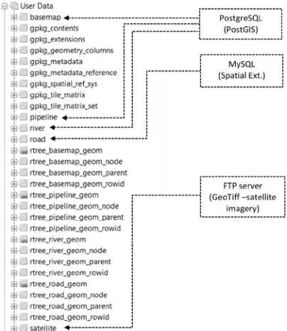
This section describes the number, type and source of data in- put used in this study for mobile utility mapping works. The data input comes from three main sources, namely PostgreSQL, MySQL and FTP server as can be seen in Table 1. The sources (database server) provide five spatial layers to be used in the util- ity mapping process. They are basemap, river, pipeline, road and satellite. Basemap layer provides information about land parcel, while pipeline layer is used for utility mapping purpose. Satellite layer is a raster data which provides satellite imagery around the mapping area. While river and road layers provides information respectively as the name implies. Another source of data input is comes from GPS data (coordinates) which is used for mapping utility objects.
Table 1. List of layers from multiple data sources.
4. RESULT
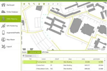
the process of data translations (pipeline). During the process, all data are translated into GeoPackage data format and encapsulated into a single file named database.gpkg. The database.gpkg is act as a temporary database in mobile application during the map- ping works. Its contained several layers inside, which consisting of vector and raster data. Figure 4 illustrates the mobile applica- tions map view showing multiple layers being mapped collabo- ratively offline. The map shows data from layers basemap, river, road and pipeline. These layers are accessed from database.gpkg located in the device storage, and access to online databases does not become a necessity. Besides, user also able to identify, pan, and zoom (in and out) the maps contents using the available map toolbars. Meanwhile, Figure 5 shows the raster layer (satellite) being mapped collaboratively with others layers in the mobile application.
Figure 4. The mobile mapping application main interface shows multiple layers being mapped collaboratively offline.
The developed mobile application demonstrate the ability to mapped geospatial data (vector and raster) in the absence of Internet con- nection. This is due to implementation of GeoPackage as internal database in the mobile application. The data format extends the capability of the developed mobile GIS application. Hence using GeoPackage in mobile GIS has caused the mapping process to become easier and efficient.
Figure 5. The mobile mapping application main interface shows raster layer (satellite) being mapped collaboratively with others
layers using data from database.gpkg.
4.1 Data organization structure
The data organization structure of GeoPackage as a single file format can be seen in Figure 6 (vector and raster). The basemap, river, and pipeline data come from the PostgreSQL database, while road data comes from the MySQL database. Raster data (satel- lite) comes from FTP server. These layers are stored as data ta- bles in GeoPackage. A vector layer stored in GeoPackage may
have additional tables that belong to the layer. For example, a layer pipeline have five tables belong to it, they are pipeline, rtree pipeline geom, rtree pipeline geom node, and others as shown in Figure 6. The tables starting with the name rtree is a spatial in- dex table that created to accelerate the spatial queries. While the raster table (satellite) is only have one table, named satellite. The others tables (gpkg spatial ref sys, gpkg contents, gpkg extensions, gpkg geometry columns, gpkg metadata, gpkg metadata reference, gpkg tile matrix and gpkg tile matrix set) are the default tables in the GeoPackage standard. Each of these tables have their own uses and purposes.
Figure 6. The data organization structure in GeoPackage for data integration of vector and raster (database.gpkg).
For vector data, the geometry data with or without optional eleva- tion (Z) and/or measure (M) is stored in SQL BLOBs. While for raster data, each tiles data are stored in BLOB data type. Besides, list of the available features in GeoPackage and its data type in- formation can be obtained by accessing the gpkg contents table. GeoPackage can be directly used to access and update data in a native storage format through the use of SQL command.
4.2 Simple and lightweight
The GeoPackage file (database.gpkg) which used to store trans- lated datasets from database server has shown its lightweight in storing multiple datasets. Figure 7 shows the comparison in term of file size between database.gpkg and satellite.tif. Its shows that database.gpkg have a file size of 3.05 megabyte, while satel- lite.tif have a file size of 19.8 megabyte. What interesting here is database.gpkg contains data consisting of basemap, river, pipeline, road and also includes data from the satellite.tif. Plus the file size is smaller than the satellite.tif in significant difference. This shows GeoPackage is good in storing large size of imagery data. It should be noted that more comprehensive study is needed to study the capability of GeoPackage in storing others raster data format.
4.3 Utility mapping
Figure 7. Comparison of two data format in file size. Left: GeoPackage data format containing vectors and raster data.
Right: GeoTiff data format (satellite image).
position and depth of the utility object. After that the identi- fied utility object is marked for the purpose of coordinates ob- servations using GPS receiver. While in the mobile application, the coordinates of the utility object with high accuracy readings is used and added to the mobile application via data editor in- terface. The added coordinates will be shown on the map as a cross-sign (cyan color) as seen in Figure 8. When the map- ping is done, field data collector can instruct the mobile appli- cation to save the update. The application will shows the latest data update via the map viewer. The mobile application write the geometry data into GeoPackage file using the standard SQL ST_GeomFromText() function. New data are updated to the tem- porary database (database.gpkg). This updated datasets are later used to update the main database when the device is connected to an Internet.
Figure 8. Newly added coordinates (points) are shown as X sign (cyan color).
5. DISCUSSION AND CONCLUSION
The developed mobile application for outdoor mapping have shown great advantages especially in spatial data management and col- laborative mapping of geospatial features in mobile platform. Spa- tial data can now be managed, accessed, edited and updated in mobile device seamlessly without worries about the compatibil- ity, suitability and reliability of data format. GeoPackage has comes to fulfil the needs in mobile application, and this format seem to encourage the process of data sharing which lead to greater mapping activities. GeoPackage is simply a schema for data stored in an SQLite database and it is not just a standard for mo- bile.
While mobile is clearly a major thrust of GeoPackage, it is not the only one. The great thing about SQLite is that it can be used in nearly every modern computing environment from a mobile device to the desktop up to the cloud. Because GeoPack- age is so flexible, users are envision it being used in a wide va- riety of ways. GeoPackage have been foreseen being a partial replacement for the Shapefile format. Several organizations are exploring ways to distribute geospatial data assets in the format. As organizations continue to adopt GeoPackage, they will con-
tinue to find new and innovative uses for it. Some of them will be mobile-based and some will not.
It is know that Shapefile has become prominent data format in the last few years. Currently shapefile is challenged due to sev- eral reasons. The reasons are maximum length of dbf field names is restricted to 10 characters; filenames should be no longer than 8 chars; no layer name (has to be derived from the filename); maximum file size is restricted to 2GB (dbf); four and more clut- tered files (.shp,.dbf.,.shx,.prj, encoding, other indexes, etc.); only MultiPoint and no MultiLinestring, MultiPolygon, GeometryCol- lection and Arcs; only one geometry per table; no topology; and no data schema (reference). The current possible data formats to replace Shapefile would be the GeoPackage or GeoJSON.
GeoJSON is an interchange geospatial data format based on JSON (Javascript Object Notation). It supports the following geometry types: Point, LineString, Polygon, MultiPoint, MultiLineString, and MultiPolygon, and very popular in web mapping applica- tions. Despite GeoPackage and GeoJSON formats overcome many of Shapefiles limitations. GeoPackage is more complex than Geo- JSON but it also provides a number of additional capabilities that some scenarios demand. As the capabilities of a database, ac- cessing and manipulating data is better than GeoJSON. For in- stances, spatial analysis can be done at data level, through simple or complex SQL spatial queries with extensions (e.g. ST_Area, ST_Buffer, ST_Centroid, ST_Contains, ST_Disjoint and etc.).
In this study the raster data (satellite imagery) is used to pro- vide images of reality. Normally MBTiles format is used to store tiles data and have been seen widely used in web map application to efficiently stores millions of tiles in a single SQLite database. The format is portable, single-file solution for storing and serv- ing web maps. GeoPackage differs from MBTiles in a few ways. The MBTiles only supports tiles in the Spherical Mercator projec- tion, while this is the default in GeoPackage, other projections are supported through an extension. MBTiles only supports a single tileset in a file, while GeoPackage supports multiple tile sets in a single file, as well as feature data and metadata (OGC, 2015a). This indicates that GeoPackage is also efficient stores tile matrix in a single file based.
The concept used in this study has put GeoPackage as interme- diate data format to supports collaborative mapping in limited network environments. Because of this, the data translation pro- cess is a must to enable application to operates in such condi- tions. Thus, further study is needed to looks on how translation process affected the original data model and data integrity. Issue to what extent the data model is preserved and maintained from the process of data translation from database (e.g. PostgreSQL) to GeoPackage, and vice versa. Whether the translation affected changes in data types (from integer to bigint, float to double, var- char to string and etc.) and data precision (0.01, 00.01 and etc.) needs to be clarified. If this happened this could be loss to the data during the format translation.
Many GIS software and programs have support reading and/or writing GeoPackage. Among them are QGIS, ArcGIS 10.3 and ArcGIS Pro, GDAL, GeoServer, GeoTools, OpenJUMP PLUS, Skyline, Luciad, Envitia MapLink, SpatiaLite, FME Desktop and FME Server, Terrago and others. There is also versions for mo- bile Android (Luciad GeoPackage Viewer).
door field works processes whereas environment network is lim- ited. This data format has a standard APIs for access and man- agement which increase interoperability and result consistency. In addition the come with the support for vector and raster data. It has shown great potential as a robust spatial database in mo- bile GIS application (outdoor mapping). This format will en- ables greater geospatial data sharing due to its ability to fulfil current needs in ubiquitous GIS development. Its interoperabil- ity in cross-platform geospatial applications, efficiency in storing multiple vectors and tile matrix in a single file, ability to directly access and update without intermediate format translations, its lightweight and minimal implementation, its open and standards- based non-proprietary data format, its capability for online and offline modes, and its database-like capabilities will enlarge po- tential market values for mobile GIS deployments.
ACKNOWLEDGEMENTS
The authors would like to express their gratitude to the research grant sponsor; the Ministry of Science, Technology and Innova- tion (MOSTI), Malaysia via ScienceFund grant (SF 04-01-06- SF1187) and Universiti Teknologi Malaysia (Grant No. 01G32) for their support in conducting the research. Gratitude to research grant sponsors.
REFERENCES
Adams, B., and Suykens, F., 2013. Astute: Increased Situational Awareness through proactive decision support and adaptive map- centric user interfaces. In Intelligence and Security Informatics
Conference (EISIC), European IEEE. pp. 289-293.
Business Wire, 2014. Everbridge adds mobile, GIS enhance- ments to unified critical communication suite. Retrieved from https://vpn.utm.my/docview/1552692341.
DSMM, 2006. Standard Guideline for Underground Utility Map- ping. National Mapping and Spatial Data Committee Malaysia,
the Department of Survey and Mapping Malaysia.
GDAL, 2015. Geospatial Data Abstraction Library http://www. gdal.org/.
Haifa, E., E., and Souheil, K., 2012. A time cost optimization for similar scenarios mobile GIS queries, Journal of Visual Lan-
guages and Computing, vol. 23, Issue 5, pp. 249-266.
Jeefoo, P., 2014. Real-time field survey using android-based in- terface of mobile GIS, 5th International Conference on Informa-
tion Science and Applications.
Jokar Arsanjani, J., Vaz, E., 2015. An assessment of a collabora- tive mapping approach for exploring land use patterns for several European metropolises, International Journal of Applied Earth
Observation and Geoinformation, Volume 35, Part B, March 2015,
Pages 329-337, ISSN 0303-2434, http://dx.doi.org/10.1016/j.jag. 2014.09.009.
Li, B., 2009. Mobile Geographic Information System Technol- ogy, Xian: Xi’an University of Electronic Science and Technol-
ogy Press, pp. 90-120.
Lwin, K., K., and Murayama, Y., 2013. Smart eco-path finder for mobile GIS users. URISA Journal, 25(2), 5+.
Mas, J., Diaz, P., Riverola, A., Daz, D., and Pons, X., 2013. Ex- changing the Status between Clients of Geospatial Web Services and GIS applications using Atom. In Proceedings of the Inter-
national MultiConference of Engineers and Computer Scientists
(Vol. 1).
MENA Report, 2013. Corporate GIS, mobile GIS and leakage management systems. Retrieved from https://vpn.utm.my/docview/ 1432351908.
OGC, 2015a. GeoPackage, an Open Format for Geospatial Infor- mation. Retrieved from http://www.geopackage.org/
OGC, 2015b. GeoPackage Standards Working Group (SWG). Retrieved from http://www.opengeospatial.org/projects/groups/geo packageswg.
OGC, 2015c. GeoPackage: Information and Data Models, Open Geospatial Consortium network. Retrieved from http://www.ogc network.net/geopackage.
Singh, R., and Bermudez, L., E., 2013. Emerging Geospatial Sharing Technologies in Earth and Space Science Informatics. In
AGU Fall Meeting Abstracts, vol. 1, pp. 08.
Youhei, K., Ashraf, M., D., Bert, V., Masahiro, H., Takeshi, S., Itaru, Ki., Hajime, N., and Kento, I., 2014. Using GIS to develop a mobile communications network for disaster-damaged areas,