AUTOMATIC ADJUSTMENT OF WIDE-BASE GOOGLE STREET VIEW PANORAMAS
KEY WORDS:panoramas, wide baseline, bundle adjustment, image matching, cartographic projection, projective transformation
ABSTRACT:
This paper focuses on the issue of sparse matching in cases of extremely wide-base panoramic images such as those acquired by Google Street View in narrow urban streets. In order to effectively use affine point operators for bundle adjustment, panoramas must be suitably rectified to simulate affinity. To this end, a custom piecewise planar projection (triangular prism projection) is applied. On the assumption that the image baselines run parallel to the street façades, the estimated locations of the vanishing lines of the fa-çade plane allow effectively removing projectivity and applying the ASIFT point operator on panorama pairs. Results from compa-risons with multi-panorama adjustment, based on manually measured image points, and ground truth indicate that such an approach, if further elaborated, may well provide a realistic answer to the matching problem in the case of demanding panorama configurations.
* Corresponding author
1. INTRODUCTION
Thanks to their obvious advantages, spherical panoramic images represent today an increasingly common type of imagery. They provide an omnidirectional field of view, thus potentially reduc-ing the number of required images and also providreduc-ing far more comprehensive views. They may be generated in various ways, yet it is today rather easy to produce panoramas with low cost-equipment and use of freely available software for automatically stitching together homocentric images onto a sphere, and subse-quently mapping them in suitable cartographic projections (Sze-liski & Shum, 1997, Sze(Sze-liski, 2006). Spherical panoramas are thus being exploited in several contexts, including indoor navi-gation, virtual reality applications and, notably, cultural heritage documentation, where the use of panoramas is now regarded as a‘natural extension of the standard perspective images’(Pagani et al., 2011).
Of course, most important is the availability of street-level pa-noramas, such as those provided by Google. Its popular service Google Street View (GSV) is a vast dataset with regularly upda-ted, geo-tagged panoramic views of most main streets and roads in several parts of the world, typically acquired at a frequency of ~12 m by camera clusters mounted on moving vehicles. Ap-plication areas of such pictorial information range, for instance, from space intersection (Tsai & Chang, 2013) to image-based modeling (Torii et al., 2009; Ventura & Höllerer, 2013), vision-based assistance systems (Salmen et al., 2012) and localization or trajectory estimation of a moving camera (Taneja et al., 2014; Agarwal et al., 2015).
A central question regarding the metric exploitation of panora-mas is their registration (bundle adjustment). Due to its omnidi-rectional nature, a spherical panorama has the properties of a sphere, i.e. it defines a bundle of3Drays. In this sense, the issue
of “interior orientation” (camera geometry) appearsin this case to be irrelevant. However, the particular cartographic projection of the panorama on which image measurements will take place must of course be known; this projection in fact represents the interior orientation of a panorama (Tsironis, 2015). Panoramas in a known projection each have, therefore, 6 degrees of free-dom. If no ground control is available, the 7 parameters of a3D similarity transformation need to be fixed.
Thus, for instance, Aly & Bouguet (2012) adjust unordered sets of spherical panoramas to estimate their relative pose up to a global scale. Of course, several simplifications are possible if camera movement is assumed to be somehow constrained (e.g. in Fangi, 2015, small angles are assumed).
A crucial related issue is, of course, automatic point extraction, description and matching. Although spherical operators have in-deed been suggested (see Hansen et al., 2010; Cruz-Mota et al., 2012), practically all researchers rely on standard planar point operators such as SIFT, SURFand ASIFT. Several alternatives have been reported. Agarwal et al. (2015) thus use conventional frames (provided by Google when requested for input from a virtual camera) and match them viaSIFTto the image sequence. Mičušík & Košecká (2009) and Zamir & Shah (2011), on the other hand, employ rectilinear (cubic) projections and SURFor SIFToperators for street panoramas. Majdik et al. (2013) gene-rate artificial affine views of the scene in order to overcome the large viewpoint differences betweenGSVand low altitude ima-ges. Others (Torii et al., 2009; Ventura & Höllerer, 2013) match directly on the sphericalGSVpanoramas but using much denser images than those freely available by Google. Finally, Sato et al. (2011) have suggested the introduction of further constraints in-to theRANSAC outlier detection process to support automatic establishment of correspondences between wide-base GSV pa-noramas.
E. Boussias-Alexakisa, V. Tsironisa*, E. Petsab, G. Karrasa a
Laboratory of Photogrammetry, Department of Surveying, National Technical University of Athens, GR-15780 Athens, Greece ([email protected], [email protected], [email protected])
b
Laboratory of Photogrammetry, Department of Civil Engineering and Surveying & Geoinformatics Engineering, Technological Educational Institute of Athens, GR-12210 Athens, Greece ([email protected])
In order to match directly on the spherical panoramas with pla-nar operators, the image base needs to be relatively short, as it is the case in most of the publications cited above. To our know-ledge, only Sato et al. (2011) have worked on directly matching between standard wide-base GSV panoramas. Such a solution assumes that tentative matches have already been established (e.g. bySIFT,SURF,ASIFT). The concept “wide-base”, however, does not refer to the absolute size of the image base itself, but rather on thebase-to-distance ratiowhich in fact determines the intersection angle on homologue rays. Our contribution focuses on matching standardGSVpanoramas of rather narrow streets in densely built urban areas. In this context, a street of ~8 m width recorded from the street center-line at a step of ~12 m produces very unfavourable base-to-distance ratios of about 3:1 with re-spect to the street façade (in this sense one might speak of‘ultra wide bases’). Such configurations produce large scale variations and strong incompatibilities between the distortions of projected panoramas (plus more occluded areas). It was thus experienced that even theASIFToperator could just produce only a few valid matches along the baseline, namely close to the two vanishing points of this direction (when the street ended at streets perpen-dicular to it).
Mičušík & Košecká (2009) point out that panorama representa -tion via piecewise perspective, i.e. projec-tion onto a quadrangu-lar prism rather than on a cylinder, permits point matching algo-rithms to perform better since their assumption of locally affine distortions is expected to be more realistic for perspective ima-ges than for cylindrical panoramas. Corresponding tentatively matched3Drays may then be validated via robust epipolar geo-metry estimation to produce the essential matrixE. However, it would be clearly preferable to create virtual views of panoramas as close as possible to affinity (as did Majdik et al., 2013, in or-der to register frames to panoramas) and subsequently apply the affine operator (ASIFT) developed by Morel & Yu (2009). Thus, the main purpose of this contribution is to describe, implement and evaluate such an alternative for “ultra wide-base” pano ra-mas. Results will be given and assessed for performed3D mea-surements and achieved accuracies.
2. RETRIEVAL AND ADJUSTMENT OF PANORAMAS
2.1 Retrieval of Google Street View panoramic images
In order to retrieve a panoramic image, an algorithm interacting with Google Maps Javascript APIand Google Street ViewAPI was implemented. The coordinates of the image center in the re-gion of interest need to be specified via the Google Maps Java-scriptAPI1. They serve as input for retrieving frames of a pano-rama via the Google Street View API2. Frame size was set to 640640, the horizontal field of view to 45º; hence, image reso-lution is determined by the field of view. Frames were collected with the yaw angle (azimuth) step set to 22.5º (50% horizontal overlap), starting at 0º (direction North), for three consecutive frame strips with respective pitch angles 0º, 22.5º and 45º (roll angle was zero). Thus, 48 frames were retrieved for a panorama.
The individual frames were stitched together to a new spherical panoramic image using the open source photo-stitcherHugin3. The software allows generating several2Dprojections of spheri-cal panoramas; here the cylindrispheri-cal equidistant projection (plate
1
carrée) was used. The size of the projected panoramas at this re-solution was around 4.9001400 (for a coverage of 360º100º), which is equivalent to an angular resolution= 0º.073.
2.2 Bundle adjustment
The geographical (,) and Cartesian (X, Y, Z) coordinate sy-stems of a sphere with O as its center are seen in Fig. 1. Its most usual representation is through a cylindrical equidistant project-ion (equirectangular projectproject-ion orplate carrée), seen in Fig. 2. A point in the image coordinate system x, y is transformed to,
by means of the angular resolution as= x,= y. Hence, each image point defines a ray in space; its equation is the basis of bundle adjustment. Since all panoramas had been requested with no rotations, the adjustment can be simplified by assuming that unknowns are only the relative translation parameters.
Figure 1. Geographical (,) and Cartesian (X, Y, Z) coordinate systems of the sphere.
Figure 2. Equirectangular projection of a panorama.
To optimize stitching (and to refine orientation),Huginexploits verticality of automatically extracted straight lines for leveling the panorama, i.e. ensuring that pitch and roll angles equal zero. This “upright constraint” of a common vertical orientation may well serve as a simplifying constraint on pose estimation (Ven-tura & Höllerer, 2013). Indeed, we adjusted with manual image point measurements several pairs ofGSVpanoramas stitched by Huginand found negligible differences in their relative rotation angles. Finally, this was also verified by similarity transforma-tions between known points on a house façade and their recon-struction from panoramas with rotation angles assumed to be zero (see Section 4).
3. AUTOMATIC POINT MATCHING AND FILTERING
As mentioned, a usual technique for automatic key-point extrac-tion and matching on panorama pairs is to change from the stan-dard equirectangular projection to a cubic one. The latter con-sists of six typical planar central projections, hence point opera-tors such asSIFT, orASIFT, may be used for feature extraction and matching. However, due to the “ultra wide” baseline con di-tions of this project, such a projection is not very efficient as no sufficient overlapping areas exist. An approach adopted here is to generatea custom projection, namely a “triangular prism pro -jection” (TPP). This consists of central projections on three ver-tical planes which form a triangular prism in 3Dspace. Each projection, which is actually a conventional perspective image, has here a field of view of 120º, both vertically and horizontal-ly.TPPplots on the horizontal plane as an equilateral triangle, with one of its vertices lying on the projection of the baseline of the stereo pair on this plane (point V in Fig. 3). Only two of the threeTPPimages are used here (4 TPPimage components per panorama, i.e. as many as in standard cubic projections), as seen in Fig. 3. Overall,TPPrepresents a generalization of the cubic projection with adaptiveFOVangle per image component, de-signed to behave optimally in similar wide baseline conditions.
Figure 3. Triangular prism projection of spheres. Red and blue are the projections of the panoramic pairs (the vanishing lines of
the vertical façade plane are projected in points V).
The particular geometry of this projection was designed for es-tablishing correspondences on adjacent panoramas; the issue of finding matches on panorama triplets has not been addressed. In spite of the use of a robust point operator such asASIFT, how-ever, no sufficient matches in any pair emerged on these projec-tions. Hence, a2Dprojective transformation is applied to each image of theTPP(which has a widerFOVthan the standard cu-bic projection, and thus allows more extended reconstruction), under the hypothesis of the planar nature of façades in urban en-vironments as well as the near-parallelism of the baselines of the stereo pairs with the basic plane of the street façade. This transformation maps the vanishing line of the façade plane back to the line at infinity (Hartley & Zisserman, 2003). In our parti-cular case, the vanishing lines do not need to be computed using image features (e.g. by line extraction to find orthogonal vanish-ing points and the vanishvanish-ing line) as their position on these pro-jections can be safely predicted. Assuming vertical façade plane and baselines which ideally run parallel to it, the vanishing line emerges as intersection of the image plane with a vertical plane containing the vector of the baseline (its trace is V in Fig. 3). A typical2Dtransformation matrix in such a case is of the type of Eq. (1):
wherel= (l1,l2,l3)Tis the vanishing line in homogeneous coor-dinates and s an isotropic scaling factor to compensate for any scaling issues that might arise under the transformation.
Theoretically, under this projective transformation a façade pla-ne, and all planes parallel to it, should be reconstructed up to af-finities. In practice, however, such rectified images are not total-ly free of projective distortions due to the uncertain location of the vanishing line; yet this does not impede the use of standard point operators like theASIFTon such“quasi-affine”views. In fact,ASIFTprovided 75-250 initial matches for each stereo pair in our tests. Evidently, not all initial matches represent authentic correspondences. For filtering out false matches, a common ap-proach relies on robust estimation of the essential matrixEfor each stereo pair. But before this, a more heuristic technique has been applied to remove obvious blunders. For all matches, the slope of the line connecting the two points, i.e. the ratio ofy to the sum ofx plus the width of the rectified image, is calcula-ted; median m and standard deviationfor these slope values are computed, and only matches with values in the range m ± k
(k = 2 or 3) are kept. In Fig. 4 a simple example is seen. Finally, all paired points remaining afterRANSACfiltering are expressed in the geographical system (,) on the panosphere by successi-vely inverting the projective andTPPtransformations.
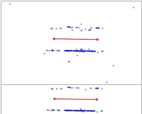
Figure 4. Outlier removal by filtering out deviating line slopes.
But even then erroneous points still manage to survive, namely wrong matches which, nevertheless, satisfy the tolerance of the epipolar constraint. Such points may be detected after a (stereo or multi-image) bundle adjustment. Here, a vertical plane was fitted to all reconstructed points of the pair usingRANSACwith a tolerance of ±1 m. Thus, point pairs with wrong disparities are filtered out (at the cost of sacrificing some valid matches). A further measure was to discard points intersected with standard errors above a limit (here 20 cm). An example is seen in Fig. 5.
Figure 6. The 11 panoramas of test data set.
Concluding, it is stressed that in this specific case (assumed pa-rallelism of baselines to the street façade) one might, of course, simply project the stereo panoramas onto a plane parallel to the
façade and perform point matching on these projections; thus, no need for two transformations (TPPprojection and projective transformation) would exist. Nonetheless we chose to adopt this more general two-step approach which might also be applicable in instances where parallelism of baselines to street façades can-not be assumed. Vanishing points would then have to be identi-fied on rectilinear projections, such asTPP, with automatic tech-niques (e.g. Rother, 2002). It is noted that alternatives for auto-matically extracting vanishing points directly on equirectangular projections have also been reported (Oh & Jung, 2012).
4. EXPERIMENTAL RESULTS
Our test data consisted of the 11 successiveGSVspherical pano-ramas (i.e. 10 stereo pairs) seen in Fig. 6. These had been acqui-red at a step of ~12 m, which coveacqui-red fully a short straight street (~120 m long, ~8 m wide). Initially, a multi-panorama adjust-ment was performed involving all images, with tie points mea-sured manually directly on equirectangular projections. About 25-50 points were measured on each panorama. It was possible (though tiresome) to carefully select a few tie points common to each panorama triplet. By fixing the projection center of one pa-norama and scaling the model via theGPSdata, unknowns were the model coordinates of the projection centers of all remaining panoramas and those of the tie points. The street runs almost prallel to the West-East direction; its axis is thus close to the X a-xis and perpendicular to the Y aa-xis (pointing North). TheRMS standard errors of the estimated locations of the projective cen-ters (Xo, Yo, Zo) in this system were:
Xo= ±25 cm Yo= ±5 cm Zo= ±3 cm
The uncertainty of camera localization emerges as significantly larger along the street axis, since it essentially depends on the li-mited number of triple intersections.
Figure 7. Common areas on theplate carréeof a panorama pair.
Figure 8. Triangular prism projections of the images of Fig. 7.
Figure 11. Final matches on two adjacent panoramas.
Figure 10. Tentative matches obtained by theASIFToperator.
As already mentioned, automatic point matching could be per-formed here only pairwise. To illustrate this process, Fig. 7 pre-sents a part of the common area of two adjacent panoramas. The corresponding piecewise perspectives of theTPPprojections are seen in Fig. 8, whereas the “quasi-affine” transformations are shown in Fig. 9. In Fig. 10 the tentative matches on these ima-ges obtained by theASIFToperator are presented. Finally, Fig. 11 shows all final matches on the two panoramas.
Here, unknowns for each panorama pair were the BY and BZ base components (for BXthe value obtained from the multi-pa-norama adjustment for the corresponding pair was used) and the model coordinates of the automatically matched tie points.
A first evaluation involves the comparison of base components BY, BZobtained by both approaches (Table 1). The results are regarded as satisfactory, taking into account that the stereo ad-justments rely on a geometrically weaker configuration. If one model is excluded (model 2 for BY, model 8 for BZ), the respec-tive values then become 110 cm and 64 cm. It is observed, however, that the stereo solution underestimates systematically the BZcomponent.
Table 1. Model base components BY, BZfrom multi-panorama and stereo-panorama adjustments, with meanand standard
deviationof their differences.
A similar evaluation involves estimations of the azimuth of the straight street axis (referred to the X-direction), as obtained per model from their BX, BYcomponents and seen in Table 2.
model
Table 2. Azimuth of street axis per model from multi-panorama and stereo-panorama adjustments, with meanand standard
deviationalong withRMSdifferences.
Here again, the model-wise automatic estimation compares well with the results from the manual multi-image solution.
A further evaluation refers to the estimation of street inclination per panorama model. Street slopes between the approximate lo-cations of panorama projection centers were directly measured with an optical inclinometer of an assumed precision of 0.75%. Slope estimates were also derived from the differences in eleva-tion BZbetween neighbouring camera positions obtained by the manual (multi-image) and automatic (stereo) adjustments. Their values are tabulated in Table 3.
reference
RMS difference:0.6 RMS difference:1.1 Table 3. Slope (%) of the 10 successive street segments.
The automatic model-wise adjustment estimates street slopes with anRMSuncertainty of 1.1%. This value is roughly equiva-lent to an uncertainty in elevation of 12 cm between camera sta-tions. Considering the inherent uncertainty of the reference data, this comparison is satisfactory. It is noted that the multi-panora-ma solution compares even better, indicating that, in principle, street slopes might be reliably estimated fromGSVimagery.
Figure 12. Ground check points.
These points, which appeared in two models (A, B), were sub-sequently intersected using their manually measured image co-ordinates and the corresponding values for BX(obtained by the multi-panorama adjustment) and BY, BZ(from the two automa-tic stereo solutions). The check points thus reconstructed were compared with the field measurements via 7-parameter3D simi-larity transformations. Results for scale differences and rotation angles are presented in Table 4 (translations are irrelevant).
results multi-panoramaadjustment
standard error 4.0 cm 5.1 cm 5.0 cm
Table 4. Results of3Dsimilarity transformations between reference and reconstructed points.
The standard error of the adjustment implies that the reconstruc-ted points fit well the ground data in all instances, namely even in the case of the automatic adjustment of independent models. The very small pitch and roll angles indicate that the “upright” assumption is realistic, in the sense that for many practical pur-poses the Z axis of suitably retrieved and projectedGSV panora-mas may indeed be considered as vertical. On the other hand, a clear scaling problem is, of course, observed between the pro-videdGPSinformation (which served for scaling the panorama models) and the field measurements.
5. CONCLUDING REMARKS
The information potential of street-level panoramic images, like those of Google Street View, is widely acknowledged. A variety of approaches and applications with differing degrees of auto-mation, such as those cited here, are being constantly reported. A crucial factor regarding automation is, obviously, the image acquisition geometry. In cases of densely built areas and relati-vely narrow streets, the current standard recording step ofGSV imagery gives rise to strongly unfavourable base-to-distance ra-tios, which further aggravate inherent distortions of panoramic configurations and representations. This puts matching among panoramas to the test.
In this contribution the possibility of synthesizing‘quasi-affine’ views of successive panoramas of street façades, which can be handled more efficiently by affine point operators, has been
in-vestigated. A suitable piecewise (rectilinear) perspective projec-tion has been used, followed by a projective transformaprojec-tion. Al-ternatively, one might consider thegeneration of ‘quasi-similar’ projections by combining the vanishing lines of the street façade and the known internal geometry of the panoramas, and then ap-ply the standardSIFTorSURFoperators instead ofASIFT.
Our first trials indicate that sufficient matches on adjacent pano-ramas may be obtained thus, allowing their successful pairwise adjustment. The described approach has produced satisfactory results. However, for the image geometry studied no matches on more than two adjacent panoramas are apparently possible, i.e. it is not feasible to perform automatic multi-panorama adjust-ments (which, of course, represent a more robust configuration against the geometry of independent panoramic stereo models). In this direction, the elaboration of representations suitable for multi-panorama matching is a topic of future research.
REFERENCES
Agarwal P., Burgard W., Spinello L., 2015. Metric localization using Google Street View.
Preprint arXiv:1503.04287v1 [cs.RO], 14 March.
Aly M., Bouguet J.-Y., 2012. Street View goes indoors: auto-matic pose estimation from uncalibrated unordered spherical pa-noramas. IEEEWorkshop on Applications of Computer Vision (WACV), pp. 1-8.
Cruz-Mota J., Bogdanova I., Paquier B., Bierlaire M., Thiran J.-P., 2012. Scale invariant feature transform on the sphere: theory and applications. International Journal of Computer Vision, 98(2), pp. 217-241.
Fangi G., 2015. Towards an easier orientation for spherical photogrammetry. International Archives of the Photogramme-try, Remote Sensing and Spatial Information Sciences, vol. XL-5/W4, pp.279-283
Hansen P., Corke P., Boles W., 2010. Wide-angle visual feature matching for outdoor localization.International Journal of Ro-botics Research, 29(2-3), pp. 267-297.
Hartley R., Zisserman A., 2003. Multiple View Geometry in Computer Vision. 2ndedition, Cambridge University Press.
Majdik A.L., Albers-Schoenberg Y., Scaramuzza D., 2013. MAV urban localization from Google Street View data.Proc. IEEE/RSJ International Conference on Intelligent Robots & Sy-stems (IROS), pp. 3979-3986.
Mičušík B.,Košecká J., 2009. Piecewise planar city3D model-ing from street view panoramic sequences.IEEEConference on Computer Vision and Pattern Recognition (CVPR 2009), pp. 2906-2912.
Morel J., Yu G., 2009.ASIFT: A new framework for fully affine invariant image comparison. SIAM Journal on Imaging Scien-ces, 2, pp. 438-446.
Oh S.H., Jung S.K., 2012. Vanishing point estimation in equi-rectangular images.Proc. 8thInternational Conference on Mul-timedia Information Technology and Applications, pp. 45-47.
D., 2011. Dense3Dpoint cloud generation from multiple high-resolution spherical images. 12th International Symposium on
Virtual Reality, Archaeology & Cultural Heritag (VAST2011), pp. 17-24.
Rother, C., 2002. A new approach to vanishing point detection in architectural environments.Image and Vision Computing, 20 (9-10), pp. 647-655.
Salmen J., Houben S., Schlipsing M., 2012. Google street view images support the development of vision-based driver assis-tance systems.IEEESymposium on Intelligent Vehicles (IV), pp. 891-895.
Sato T., Pajdla T., Yokoya N., 2011. Epipolar geometry estima-tion for wide-baseline omnidirecestima-tional street view images.IEEE International Conference on Computer Vision Workshops, pp. 56-63.
Szeliski R., 2006. Image alignment and stitching: A tutorial. Foundations and Trends in Computer Graphics & Vision, 2(1), pp. 1-104.
Szeliski R., Shum H.-Y., 1997. Creating full view panoramic image mosaics and environment maps.Proc. 24thAnnual Con-ference on Computer Graphics & Interactive Techniques, SIG-GRAPH’97, pp. 251-258.
Taneja A., Ballan L., Pollefeys Μ., 2014. Neverget lost again: vision based navigation using StreetView Images.Asian Confe-rence on Computer Vision (ACCV2014), Lecture Notes in Com-puter Science, Springer, vol. 9007, pp. 99-114.
Torii A., Havlena M., Padjla T., 2009. From Google Street View to3Dcity models.IEEEInternational Conference on Com-puter Vision Workshops, pp. 2188-2195.
Tsai V.J.D., Chang C.-T., 2013. Three-dimensional positioning from Google street view panoramas. IET Image Processing, 7(3), pp. 229-239.
Tsironis V., 2015.Study of the Geometry of Spherical Panora-mas. Diploma Thesis, Faculty of Rural & Surveying Engineer-ing, National Technical University of Athens, Greece.
Ventura J., Höllerer T., 2013. Structure and motion in urban environments using upright panoramas.Virtual Reality, 17(2), pp. 147-156.
Yu G., Morel J.M., 2011.ASIFT: An algorithm for fully affine invariant comparison, image processing on line.
DOI:10.5201/ipol.2011.my-asift.