The Use of Web GIS Among Local Authorities:
A Survey of the Contents and Level of Services
by:
Haiza Wahida Haron & M. Rafee Majid
Dept. of Urban and Regional Planning Universiti Teknologi Malaysia 81310 Skudai, Johor, Malaysia
Emails:[email protected], [email protected]
Abstract
An efficient planning process can benefit tremendously from information technology and geographic information system (GIS). Both information technology system and GIS are helpful, if not yet essential, in supporting complex decision making processes. An advanced form of GIS, Web GIS is capable of disseminating data, especially spatial data, widely over the internet for a wider audience. Theoretically, this would make the data more accessible to the public and the decision-making process more collaborative. One of the ways to check whether or not this is true in practice is by surveying the contents and level of services of those web GIS’s offered by a sample of planning agencies/local authorities. This paper discusses the results of a study made on the contents and level of services offered by some web GIS sites from Malaysia and USA. Analysis of the contents of web GIS was done through simple online observation while level of services (LOS) was analysed on the basis of the level of contents (LOC) and level of GIS functions (LOF) offered. LOS was ranked from the lowest level of delivering general static information to the public to the highest level of distributing interactive information that supports decision making in planning process. The study found that there were varied contents of web GIS and several levels of services, depending on the purpose of the web GIS.
Keywords: web GIS, local authority, GIS, spatial planning
______________________________________________________________________________
INTRODUCTION
hundreds of thousands of telecommunication networks and creates an ‘internetworking’ framework. In another hand, internet GIS is a framework of network-based geographic information services that utilize both wired and wireless internet to access geographic information, spatial analytical tools, and GIS web services. Today, many local authorities have used web GIS as a part of their services to serve their communities.
One of the main uses of web GIS that has been promoted is for the distribution of geospatial data. This includes the distribution of geospatial data to stakeholders, organizations and the public. Examples of Malaysian web GISs developed for this purpose are those of DBKL (Kuala Lumpur Municipal Hall) and AGISwlk (Ahris Yaakup et al., 2004; Ahris Yaakup, 2006). Both of these web GISs provide public with access to GIS interactive maps with information on properties, land uses, development zones, etc. With easy menus and functions, users can browse or search for information through the web. The level of information provided can be varied according to its intended users and access to information can be regulated through the use of login and password if so desired. With easy access to information via the internet (i.e. web GIS), there has been increased participation from the communities on issues relating to community planning (Carver, 2001; Granberg and Åström, 2004).
Web GIS has also been promoted as a platform for data sharing that is both effective and fast. Through web GIS, data sharing between agencies or organizations regardless of their proximities can be done in a fast and effective manner. This is in contrast with the traditional way of data sharing which is time consuming. Through web GIS, users can also process and manipulate spatial data online such as doing simple analyses using the spatial data. This analysis can be done by customizing the user interface with simple analysis functions. One simple example is the Slaithwaite Web GIS (Carver et al., 2004; Kingston et al., 2000) which provides the community with mark up functions on the web that lets the user to comment on the data directly on map. In planning, web GIS can also support the concept of e-governance by encouraging, through the internet, the two-way interactions between government and citizen, government and government as well as government and non-profit organizations (Montagna, 2005).
This paper summarizes the results of a study on the appearance, contents and level of services offered by some web GIS sites from Malaysia and USA. Analysis of the appearance and contents of these web GIS sites was done through simple online observation while the level of services (LOS) was analysed on the basis of the level of contents (LOC) and level of GIS functions (LOF) offered. The samples were randomly chosen online with no pre-qualification except that they have to be from a local or regional planning authority.
METHOD
Table 1.0: Web GIS sites studied.
Sample Web Address
MALAYSIA
City Of Lincoln, Nebraska Town of Amherst,
ZIMAS, City of Los Angeles Fulton County, Atlanta City of Fairfield, Ohio Honolulu County, Hawai PlanNet – Maricopa County Town of Fishers
Gila County, Arizona
City of Milwaukee, Wisconsin City of Austin (DevWeb)
Town of Orchard Park, New York City of Greensboro, North Carolina City of Huntsville, Alabama
http://www.kwp.gov.my
The first part of the study involved the general observation of the contents of the web sites. This content analysis evaluated each web GIS site on the following:
Functions of Web GIS. The main functions of each web GIS site were determined.
Functions of web GIS include display of general information for the public, display of planning information, interactive display of spatial information, sharing and distribution of spatial data as well as management of spatial data.
User Interface. The user interface of each web GIS was evaluated to check whether it was
friendly or complicated for its targeted users. User friendly interface is characterised by menus and icons that are attractive and easy to understand. The interface should be easy enough to be quickly learned and uses common terms.
Graphic Appearance. Interesting graphics are defined as graphics that are easy to the eyes
and make full use of colours, sizes, scales and arrangement. It should be cautioned here that the assessment is purely based on the authors personal experience and taste.
Web GIS Software. There are many brands of software used to develop web GIS at the
Web GIS Data. Web GIS data were assessed based on how detailed were the maps provided. This can be general maps at regional level or very detailed maps down to lot level.
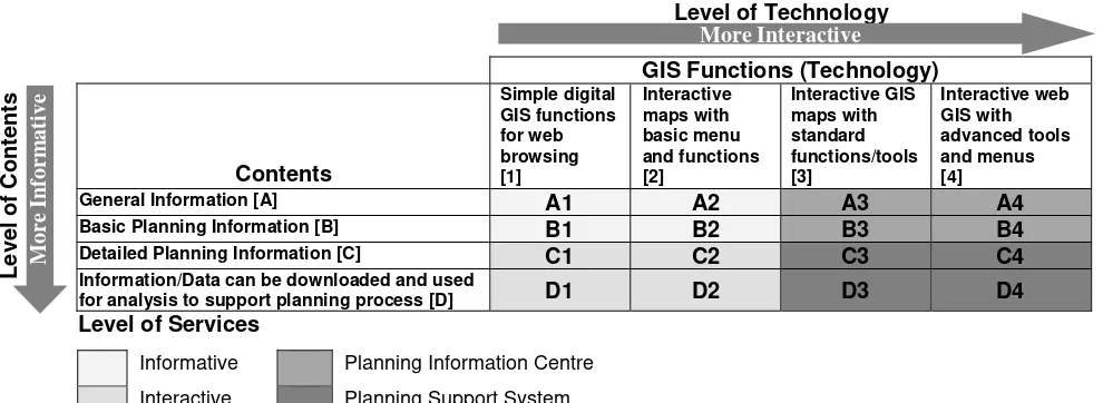
The second part of the analysis determined the Level of Service (LOS) of each web GIS site based on the Level of Contents (LOC) and the Level of its GIS Functions or Level of Functions (LOF). A Cross Tabular Matrix (CTM) approach shown in Table 2.0 as used by Arleth et al. (2006) and Zhon-Ren Peng (2001) was adopted for this study. In the matrix, the LOC is ranked from 1 to 4 with the explanation on the ranking shown in the table and the LOF is ranked from A to D. Briefly, the ranking of the LOC can be described as below:
Level A. Only general information such as locations, travel guides, basic amenities, etc. are
displayed to give updated information to the public. The web functions more like an information kiosk.
Level B. Information displayed at this level contains some additional items such as basic
planning information like land uses and building information.
Level C. At this level, web GIS displays information that helps decision making processes or encourages participation from various parties in the planning process.
Level D.The information provided at this level tends to be more specific, can be downloaded
and used for all kinds of planning analyses or shared/used interactively between agencies. The ranking of the LOF meanwhile can be briefly described as below:
Level 1. Maps at this level are static and in HTML or PDF format. There is no interactive
function within the web site and users can only view static maps.
Level 2. Some basic functions are allowed on maps displayed at this level. These functions
include zoom in/out , pan/move, full map/full extent and query of data attribute/identify. These functions are mainly use to display some simple and general information.
Level 3. Web GIS functions at this level go beyond the basic display functions to include
additional functions such as data search, choice of map layers and measurement. The interaction between the user and the web is higher at this level with the additional functions.
Level 4. The sophisticated interactive fuctions at this level allow for comments to be made
online, simple analyses to be carried out, download of data and complex search functions to be performed. This advanced level of web GIS functions enable two-way communication between users and the GIS web site as well as the management of the web GIS.
Table 2.0: Comparison matrix on level of contents and level of functions in a web GIS
GIS Functions (Technology)
Information/Data can be downloaded and used
for analysis to support planning process [D] D1 D2 D3 D4
Level of Services
Informative Planning Information Centre
Interactive Planning Support System
The combination of the LOC and the LOF ranks of each web GIS site gives it its LOS rank which can range from Level A1 (the lowest level) to Level D4 (the highest level). At Level A1, the web GIS services are focused on delivering general information to the public using static display. On the other extreme, Level D4 represents the highest level of web GIS services which is distributing information and getting feedbacks to help support decision making in planning process.
RESULTS and DISCUSSIONS
Functions and Contents
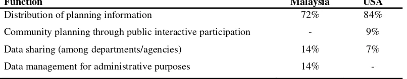
Based on the online survey, there were four main Web GIS functions; i) distribution of planning information, ii) a platform for community planning (through public interactive participation), iii) a platform for sharing data, and iv) a platform for managing GIS data. Distribution of planning information is the single most important function where it represents 72% and 84% of the main function in Malaysia and the USA respectively (Table 3.0). Even though web GIS was seen as an emerging tool for public participation in planning (Kingston et al., 2000; Steinmann et al., 2004), its use for this purpose was just starting. Only 9% of the USA web sites surveyed offered this function while none of those in Malaysia did. However, the use of web GIS for data sharing and data management was found to be popular in Malaysia where 14% of sites surveyed showed that data sharing and data management were their main functions.
Table 3.0: Main functions of web GIS sites.
Function Malaysia USA
Distribution of planning information
Community planning through public interactive participation Data sharing (among departments/agencies)
Data management for administrative purposes
72% - 14% 14%
84% 9% 7% -
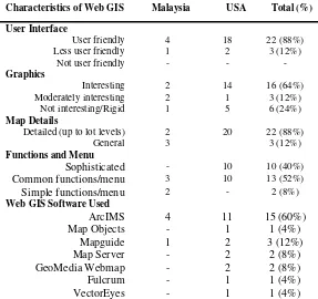
In term of their characteristics, majority of the web GIS sites were found to be user friendly. This characteristic is important to achieve the purpose of publishing data on the web. Eighty eight percents of them were user friendly while 12% were less user friendly with none of them was not user friendly. One possible reason for some web GIS sites being less user friendly is these sites target only expert users instead of the lay public. User friendliness is here defined as sites that have menus and icons that are attractive and easy to understand by the public. The interface should also be easy enough to be quickly learned and uses common terms. Besides user friendliness, graphics too are important to make a good web GIS site. Almost seventy six percents of the sites surveyed were evaluated as having interesting or moderately interesting graphics while the rest were rated as having rigid or uninteresting graphics. Interesting graphics are those that are easy to the eyes and make full use of colours, sizes, scales and arrangement. The assessment, however, was purely based on the authors personal experience and taste.
level. All the three sites that had only general maps were Malaysian sites that were meant for regional planning purposes, the planning level that does not require maps down to individual lots. In term of menus, a total of ten sites (40%) offered sophisticated menus while thirteen sites or 52% had menus that could perform only common functions. Examples of sophisticated menus are menus that allow users to perform certain types of spatial analysis such buffering, neighbourhood analysis, etc while common menus allow users to perform standard operations such as zooming, panning, etc.
When it comes to web GIS software, majority (60%) of the sites were developed using ESRI’s ArcIMS. The popularity of ArcIMS could be attributed to the wide usage of ESRI’s ArcView or ArcGIS GIS software. It is only natural to use ArcIMS for publishing of GIS product on the internet if one uses ArcView or ArcGIS for his/her GIS works. Three other web GIS softwares at a distant second are MapGuide (12%), MapServer (8%) and GeoMedia Webmap (8%). Table 4.0 below summarizes the characteristics of the web GIS sites surveyed.
Table 4.0: Characteristics of web GIS surveyed.
Characteristics of Web GIS Malaysia USA Total (%)
User Interface
Web GIS Software Used
ArcIMS
Level of Services (LOS)
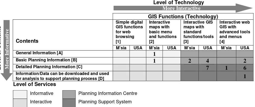
Most of the American web GIS sites meet Level C3 or above. These web GIS sites not only contain detailed planning information but also allow for interactive access of the information using advanced GIS functions for analysis and community participation purposes. These web GISs are designed as a planning information centre or a planning support system. The only web GIS site that meets the specifications of Level D4 is the OLIVER web GIS site developed by the State of Massachusetts GIS. It has thirty interactive map applications and twenty nine browser-based mapping functions for display and retrieval of spatial information. It also has a collection of satellite images for display.
Table 5.0: Distribution of web GIS sites according to level of services
GIS Functions (Technology)
Information/Data can be downloaded and used
for analysis to support planning process [D] 1
Level of Services
Informative Planning Information Centre
Interactive Planning Support System
CONCLUSIONS
The study shows that planning authorities, through web GIS, are beginning to capitalise on the use of the internet for decision making involving the public. There are however still a considerable difference between the two countries concerned in the functions and LOS of the web GISs sampled, although there is not much difference in other areas. Web GISs in the USA are better designed for interactive community involvement in planning process that those in Malaysia. The American web GISs also offer higher LOS than their Malaysian counterparts with more detailed planning information. This reflects the maturity of web GIS development in the country as indicated by the numerous number of web GIS sites currently in operation compared to the number in Malaysia.
The study also shows that currently in practice the two most important functions of web GIS are distribution of planning information and supporting of decision making process. However, the study also shows that not all local authorities have the same uses for their web GIS. Thus, it is of prime importance to establish the functions and LOS of web GIS required by a particular local authority before deciding on the design of the web GIS. Not all local authorities need, for instance, a Level D4 web GIS. Some will be adequately served with a Level B2 web GIS or a different level.
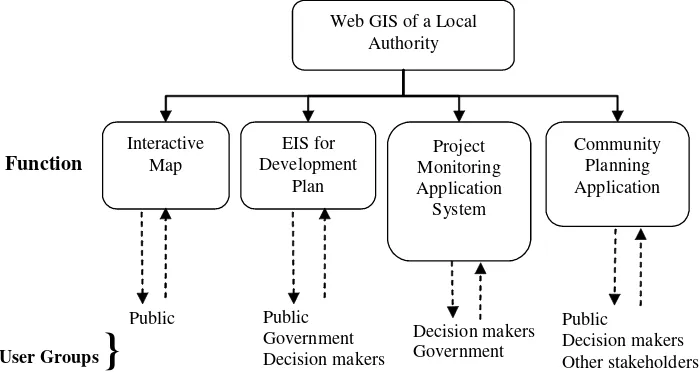
The contents of a web GIS are very much dictated by the functions and LOS of the web GIS and the targeted user groups. In general, there are three levels of web GIS users which are the administrative users, expert or professional users, and general users or the general public. Identifying the targeted user groups and their requirements helps determine the structure, appearance and contents of a web GIS that can fully serve its functions. Figure 1.0 below proposes one example of web GIS for a local authority showing its contents and targeted users.
Figure 1.0: An example of a Web GIS structure for a local authority
Last and certainly not least, deciding on what software to use is also crucial. There are quite a variety of both commercial and open source softwares are now available with their inherent strengths and weaknesses. Commercial softwares might be costly but they come in one simple package and with technical support while most of the zero-cost open-source softwares need to be customized using source codes or toolkits, or combined with other softwares. While open-source softwares might not be for the uninitiated, they have higher flexibility than the commercial ones. Either commercial or open-source, the choice of software depends on the budget, web GIS needs and technical know-how of the organization.
REFERENCES
Ahris Yaakup, Yazid Abu Bakar , Susilawati Sulaiman (2004). “Web-based GIS For Collaborative Planning And Public Participation Toward Better Governance”. GISDECO 2004 Proceedings Paper. Kuala Lumpur, Malaysia.
Ahris Yaakup (2006). “GIS for Malaysian Development Planning Process”. GIS Development – Malaysia. Vol 1 Issue 2, April – June 2006.
Arleth M., Krek A., Campagna M. (2006). Distribution Of Public Administration GI-Based Websites: Towards A Cross European Comparison Study. Available at http://www.salzburgresearch.at. Accessed on 10 August 2006.
Carver S. (2001). Participation and Geographical Information:A position paper.Position paper for the ESF-NSF Workshop on Access to Geographic Information and Participatory Approaches Using Geographic Information.UK. School of Geography, University of Leeds.
Web GIS of a Local Authority
Project Monitoring Application System Interactive
Map Community Planning
Application EIS for
Development Plan
Public Public Government Decision makers
Decision makers Government
Public
Decision makers Other stakeholders
User Groups
}
Carver S., Evans A., Kingston R., Turton I. (2004). Virtual Slaithwaite: A Web Based Public Participation 'Planning for Real'® System. School of Geography, University of Leeds,
United Kingdom, Available at http://www.geog.leeds.ac.uk/papers/99-8/#1. Accessed on 10 August 2006.
Granberg M., Åström J. (2004). Digital Democracy And Planning: Swedish Local Authorities On The Web. Paper for presentation at the XIII Nordiska Kommunalforskarkonferensen. 26-28 November 2004. University of Oslo, Norway.
Kingston R., Carver S., Evans A.,Turton I. (2000). “Web-Based Public Participation Geographical Information Systems: An Aid To Local Environmental Decision-making”. Computers, Environment and Urban Systems. 24 (2000), pp. 109-125.
Montagna J. M. (2005). “A Framework For The Assessment And Analysis Of Electronic Government Proposals”. Electronic Commerce Research and Applications. Vol 4, No. 3, pp. 204–219.
Peng, Zhong-Ren (2001). “Internet GIS for public participation”. Environment and Planning B: Planning and Design. Vol 28, pp. 889 – 905.
Peng, Zhong-Ren, Tsou, Ming-Hsiang (2003).Internet GIS: Distributed Geographic Infomation Services For The Interenet And Wireless Networks. John Wiley & Sons, Inc.. New Jersey, USA.